Showing 3382 items
matching bridge road
-
 Halls Gap & Grampians Historical Society
Photograph - Coloured, C 1980s (?)
Photo shows old wooden rail bridge curved up and over a creek. A man is standing on bridge looking down, a woman is kneeling behind man and is also looking down. Tree branches are leaning over bridge.'Old rail bridge"structures, bridges, trains -
 Halls Gap & Grampians Historical Society
Photograph - B/W, C 1932
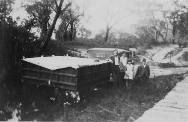
A family on holiday in the Grampians. The deep wagon is an early form of caravan, which folded down and was ready to erect when a site was found. The man is Jack Diamond from Donald.The photo shows a family (a man, a woman, a girl and a boy) standing beside an old car pulling a deep, wooden wagon covered by a tarpaulin. A mans hat sits on the tarpaulin near the man's elbow.The wagon appears to be standing in water and there is a wooden slat surfaced bridge ortrestle to the right. A track with two signposts is in front of the car and there is thin bush in the background.recreation, camping, transport, cars -
 Halls Gap & Grampians Historical Society
Photograph - B/W, C 1920 (?)
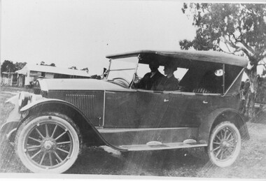
The woman in the photo is Ruth Pickering from Dadswell's Bridge.The photo shows a man and a woman seated in a car (Chevrolet ?). A building can be seen in the background.peopletransport, cars -
 Halls Gap & Grampians Historical Society
Photograph - Photocopy, C 1925
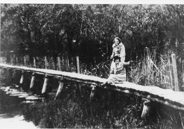
The woman's name is Mavis Klauss and the boy is Arthur Klauss. The bridge is over the McKenzie Creek at Zumsteins. The Klauss family often camped in this area.The photo shows a woman and boy sitting on a bridge dangling their feet over a wide creek. A horse is teathered in the background on the left of the photo, where a building can also be seen.people, klauss, structures, bridges -
 Halls Gap & Grampians Historical Society
Photograph - B/W
Photo of foot-bridge over the Wannon crossing. c1920-Photo shows 2 women one seated, one standing on a wooden foot-bridge; both are wearing overcoats, one is wearing a hat. The bridge has post & wire fence on one side. Bush in background is thick so too reeds & rushes.structures, bridges -
 Halls Gap & Grampians Historical Society
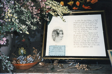
Photograph - Coloured
Part of a display at the 1992 Wildflower Show. The historical description relates to Jack Watson, the convenor of the first Wildflower Show in 1933. For further information about Jack Watson see "Bridging the Gap", pp 88 & 91.The photo shows a framed historical description about Mr Jack Watson, including an oval photo and a blue "Wildflower Show" admission ticket. On the left of the photo, beside the frame, is a display of wildflowers in a vase and a dried display beneath it in a basket/bowl.events, wildflower show -
 Halls Gap & Grampians Historical Society
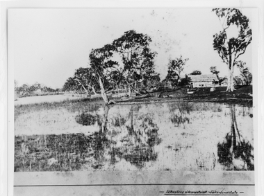
Photograph - B/W, c 1869
Photo is said to be of Schoolers' homestead,Lake Lonsdale. Miss Scouller was the teacher at Halls Gap Primary school in 1921.Spelling of Schooler varies from that on front of photo to 'Scouller' which appears in book "Bridging the Gap'.Photo shows bark roofed building on a bank of a body of water . A number of large gum trees surround the buildings-- tree reflections can be seen in the water. There appears to be extensive fencing around the buildings. The homestead is not visible.buildings, houses -
 Halls Gap & Grampians Historical Society
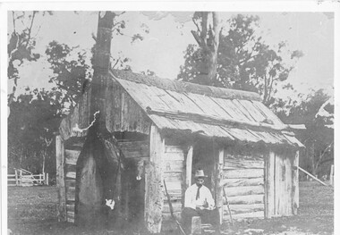
Photograph - B/W, c 1850s
This windowless bark hut would have been used by stockmen who looked after sheep and cattle in the Fyans Valley. This hut was situated at the site later named the Borough Huts. See p8 Bridging the Gap Photo shows a man sitting outside a wooden slab hut. The hut has a tin flashing along top roof line. Man is wearing a hat and tie. A gun is leaning up against wall of hut. A sheep or cattle race can be seen in left corner of photo. buildings, houses -
 Halls Gap & Grampians Historical Society
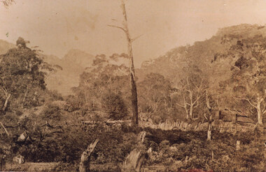
Photograph - Sepia, c 1876
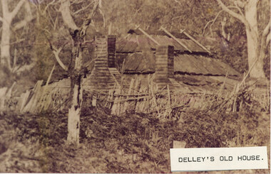
Photo is of Delley's home with the " Watchtower�" in the background. Further information see "Bridging The Gap" p13-14,17,22,54. Records 544 & 545 are enlarged portions of this photo.Photo shows old house to right side of photo. There are two chimneys and the lower half of the house is obscured by a stick fence and undergrowth. The mountain range can be seen faintly in the distance. A dead tree can be seen middle foreground. buildings, houses -
 Halls Gap & Grampians Historical Society
Photograph - B/W
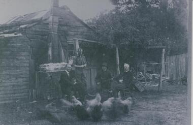
Fred Paasch was born in Denmark in 1862. It is unknown when he arrived in Australia or when he settled in Halls Gap. He owned land generally in the area now occupied by the Halls Gap Supermarket where he established an orchard. See " Bridging the Gap " p.58-60 "Victoria's Wonderland" p.98-99.Shingle and slab house, chimney has loose brick base and tin flue. Four men in foreground. Freddy Paasch, owner of the house is seated in the centre. A number of hens feed in the near foreground. A climbing rose coyers the fence and part of the house roof.buildings, houses, people, paasch -
 Halls Gap & Grampians Historical Society
Photograph - Sepia, C 1876
This is a photo of Delley's house. For further information see "Bridging The Gap" p13-14,17,22,54. This photo is an enlargement of a portion of Record 531.Photo shows old house. The roof is constructed of wooden slats held down by pieces of what appears to be fluming. There are two chimneys and the lower half of the house is obscured by a stick fence and undergrowth. There is a large tree in the foreground and another in the far right background. The house is surrounded by bush.buildings, houses -
 Halls Gap & Grampians Historical Society
Photograph - Coloured
An old bridge on the Heatherlie Quarry rail line at Back Creek, this line was used to transport sandstone from the quarry to Stawell.Photo shows an old bridge with 3 adults at the end, one male standing and 2 adults sitting. The bridge consists of large wooden beams,cross beams and supports .water can be seen at the bottom of the depression. Bush surrounds the bridge.structures, bridges -
 Halls Gap & Grampians Historical Society
Photograph - Coloured
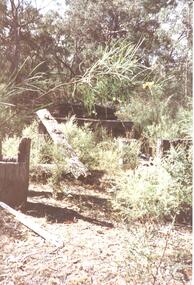
An old bridge at Back Creek on the Heatherlie Quarry Rail line.Photo shows the beginning of a bridge that has become dilapidated with time. Large beams lie around covered in weeds. Bushy growth has grown over the bridge.structures, bridges -
 Halls Gap & Grampians Historical Society
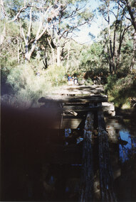
Photograph - Coloured, C 1980s
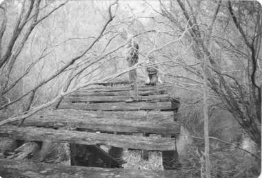
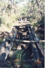
This is a photo of one of the trestle bridges on the Heatherlie Quarry train line. The bridge is located near the current location of "The Pines" campground.The photo is a "front on" of a derelict trestle bridge crossing a shallow creek; many sleepers are missing and thick bush and trees surround the bridge. There are four adults at the end of the bridge, one standing and three seatede. The bottom left hand side of the photo is blurredstructures, bridges, quarrying, heatherlie -
 Halls Gap & Grampians Historical Society
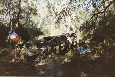
Photograph - Coloured, C 1980s
This is a photo of one of the trestle bridges on the Heatherlie Quarry train line. It is located near the current site of "the Pines" campground.Photo shows an angle a derelict bridge with many sleepers missing. Thick bush and trees on left side with weeds in the front. The bridge is over a shallow creek. At the far end of the bridge a man wearing a pink cap and blue jumper stands looking towards camera. Three adults are seated and partly out of picture.structures, bridges, quarrying, heatherlie -
 Halls Gap & Grampians Historical Society
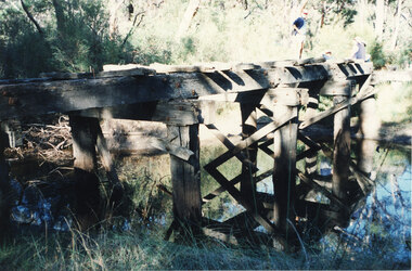
Photograph - Coloured, C 1980s
This is a photo of one of the trestle bridges on the Heatherlie Quarry train line. It is located near the current site of "the Pines" campground.Photo is of a derelict trestle bridge over a shallow creek, taken on an angle. There are many sleepers missing and the bridge is surrounded by thick bush and trees. There is bracken in the foreground. A woman wearing a blouse made of material with a white background with a colourful pattern, blue jeans, a white "golf shade" and a red jumper ot jacket tied around her waist is walking on the near side of the bridge. Two men and two women are standing at the opposite end.structures, bridges, quarrying, heatherlie -
 Halls Gap & Grampians Historical Society
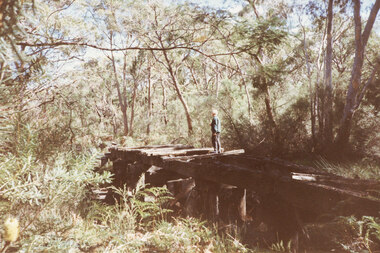
Photograph - Coloured, C 1980s
This is a photo of one of the trestle bridges on the Heatherlie Quarry train line. It is located near the current site of "the Pines" campground. The woman on the bridge is Janet Witham.Photo is of a derelict trestle bridge over a shallow creek, taken on an angle. There are many sleepers missing and the bridge is surrounded by thick bush and trees. There is bracken in the left foreground. A woman wearing a blue top and grey/brown slacks.structures, bridges, quarrying, heatherlie -
 Halls Gap & Grampians Historical Society
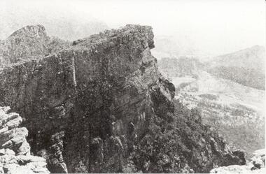
Photograph - B/W
Relph Peak, named after A.U. Relph of the Government Tourist Department. See P67 of Bridging the Gap, by Ida Stanton. Steep rocky escarpment, valley down below, smaller range opposite, mountain rising higher in background.scenery, wonderland range -
 Greensborough Historical Society
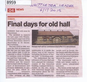
Article - Newspaper Clipping, Whittlesea Leader, Final days for old hall Doreen, 06/01/2015
In 2015 the Doreen Hall was demolished as part of the Doreen Recreation Reserve masterplan and to allow works on Bridge Inn and Yan Yean Roads.Newspaper Clipping, text and colour imagedoreen, whittlesea, doreen community hall -
 Halls Gap & Grampians Historical Society
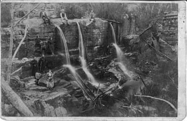
Photograph - Sepia, C 1900s
Some of the people in the photo are said to be members of the Balmain family. James and his wife Amy Sophia (nee D' Alton) had three children. Amy died suddenly in 1902 at the age of 37. See p45 Bridging the Gap.Photo shows group of people seated and standing by a waterfall,three men seated on top of waterfall, next level a man and a young woman ( who is holding a hiking stick), top level a man and woman both holding hiking sticks. In front of them seated on a rock is a woman holding a hat. on her lap Waterfall is split into three and they flow over a larger rocky platform.Balmains c1900recreation, bush-walking -
 Halls Gap & Grampians Historical Society
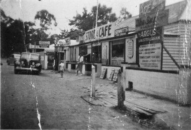
Photograph - B/W
See 'Bridging the Gap' p65. Grampians Road Halls Gap.Group of shops with numerous advertising signs. A woman is leaving a shop, a young girl is standing in front of her. Two cars are parked in front of shops. Gravel road. Large gum trees in the background.buildings, shops -
 Eltham District Historical Society Inc
Photograph, Edendale Farm, Eltham Heritage Tour, 24 May 1992, 24/05/1992
ELTHAM HERITAGE TOUR The Society excursion on 24th May 1992 was arranged by David Bick, leader of the team carrying out the Shire's heritage study. David selected a number of sites or buildings identified in the study, some of them lesser known components of the Shire's heritage. The tour commenced at the Eltham Shire Office at 10.00 am. Travel was by private car and mini-bus with stops at about twelve locations for commentary by David.It included a short walk in Hurstbridge and lunch at Kinglake. Highlights of the tour included: - 10 am Leave from Shire Offices - 3 Important Trees - A Physical Link to Eltham's First Settlers - Toorak Mansion Gates - A Surviving Farm House - An Intact Circa 1900 Main Street - First Settlers - Gold Miners, and Timber-getters - An Early Hotel - A Pioneering Homestead - Changing Eltham Shire - 20th Century - 4 pm Afternoon Tea and Finish Tour Extract from ELTHAM CULTURAL HERITAGE TOUR (Newsletter No. 85, July 1992, by Bettina Woodburn) "The land was unprofitable for intensive farming, but there was always water in the Diamond Creek. The railway, a technological advance, followed the valley, and was provided to transport produce. At North Eltham we were privileged to tour a surviving farmhouse of the 1860-70 era at the Shire’s Edendale Farm, with the as yet unfinished Sculpture for a front fence - bulbous tree-trunks decorated with salt pots, with cross members from the old trestle bridge. As was usual these six veranda posted houses faced South (or East, away from the sun!) with the scullery, kitchen and pantry "out the back". The veranda, which must have been very narrow, no longer exists. It probably wrapped around three sides. The drive took us past the Dutch Windmill, only twenty years old and in the Shire of Diamond Valley, then the Diamond Creek Cemetery with impressive gateway, to a detour to see another old farmhouse, isolated on a hill off Murray Road Wattle Glen. Here was a particularly thick patch of exotic planting of pines and cypresses. Subsistence farming no longer pays. Following the rail-line we noticed on the left near Silvan Road an Edwardian cottage and on the right near Yates Road the old school residence for this Upper Diamond Creek area."Record of the Society's history and activities and highlighting various aspects of the Heritage Study undertaken by David Bick used to create the future heritage overlay for the Shire of Eltham and later Nillumbik Shire.Roll of 35mm colour negative film, 4 stripsKodak Gold 100 5095eltham, shire of eltham historical society, activities, heritage tour -
 Eltham District Historical Society Inc
Photograph, Upper Yarra Dam, Spring Tour, 22 Oct 1995, 22/10/1995
EXPLORING THE UPPER YARRA (Newsletter No. 105, November 1995, by Bettina Woodburn) We enjoyed the Spring Excursion, this year "Exploring the Upper Yarra" - in spite of the constant rain and the countryside under the cloud cover, especially in the valleys, being mainly shiny shades of green. The occasional fields of buttercups, clumps of arum lilies and splendid rhododendron and other flowering bushes became very special. The Cobb and Co coach was warm and a cosy retreat as we zig-zagged on the highways and byways to glimpse the Yarra River, upstream and down, its secret places, and particularly the many bridges. Russell excelled as 'Poet Laureate', reading from Dacre Smyth's book. This 1979 publication includes paintings of all the bridges along the river with poems and brief descriptions of each one. Some of the bridges are in out of the way places and are not very well known. We looked forward to hearing the poetry as much as seeing the ' constructions'…Big Pat (was he short or tall, lean or fat? He did win the two hundred pound reward for discovering gold and had the creek named after him), about the 'Eddies'?, and the disliked 'meccano' bridge in Warburton, etc. etc. The hot roast lunch in the old Reefton Hotel was also most welcome. It was easy to imagine it peopled by miners and early settlers. Starting by crossing the new (1974) concrete bridge at Warrandyte we headed through Wonga Park with views to the Christmas Hills and to the escarpment of the Yering Gorge, which causes flood waters to back up through the Yarra Glen plain, so avoiding disasters downstream. At the end of a long driveway we found the wooden, privately owned Henley Bridge (1935 after the 1934 floods). This facilitates access to different parts of Henley Farm and to Lilydale. Everard Park, named after Blanche Shallard's father, a State Member for 17 years, below the Highway Yarra crossing was in need of care. It is 10 miles from Yarra Glen by road but, as "Yarra Marra” canoeists well know, 32 winding miles down by water. After more delightful countryside scenes we joined the Warburton Highway at Woori Yallock. From the old Railway Station at Launching Place the Centennial Trail for walkers, cyclists and ' horse riders has replaced the rails. The line from Lilydale was opened in 1901, and the last diesel freight train ran to Warburton in 1965. It continued to rain as we had morning tea in Warburton in a shelter between footbridges. From here we continued upstream past the Bridge to O'Shannasy Lodge and Reservoir, Starvation Creek, and the Peninsular tunnel (miners dug it as at Pound Bend) which we visited (scrambling down those steps!) on our return after lunch. Our furthermost point was the Upper Yarra Dam Reserve (and vast catchment area). Finished in 1957 after ten years work and 100 years after Yan Yean, it supplies much of Melbourne's water. After crossing the 30m Launching Place Bridge to the Eltham side of the Yarra and Healesville, we saw in the distance the Yarra Glen Timber Trestle Bridge over the river flats "the longest for years in the land it was said!" Harry's dream of "better weather over the Divide" unfortunately didn't come true, but I'm sure we 36 members will retain happy memories of a day that was wet and green and filled with Bridges. Bettina Woodburn - October 1995 Record of the Society's history of activities - Spring 1995 excursionRoll of 35mm colour negative film, 3 stripsKodak Gold 200-4shire of eltham historical society, activities, upper yarra dam, henley bridge -
 Eltham District Historical Society Inc
Photograph, Upper Yarra Dam, Spring Tour, 22 Oct 1995, 22/10/1995
EXPLORING THE UPPER YARRA (Newsletter No. 105, November 1995, by Bettina Woodburn) We enjoyed the Spring Excursion, this year "Exploring the Upper Yarra" - in spite of the constant rain and the countryside under the cloud cover, especially in the valleys, being mainly shiny shades of green. The occasional fields of buttercups, clumps of arum lilies and splendid rhododendron and other flowering bushes became very special. The Cobb and Co coach was warm and a cosy retreat as we zig-zagged on the highways and byways to glimpse the Yarra River, upstream and down, its secret places, and particularly the many bridges. Russell excelled as 'Poet Laureate', reading from Dacre Smyth's book. This 1979 publication includes paintings of all the bridges along the river with poems and brief descriptions of each one. Some of the bridges are in out of the way places and are not very well known. We looked forward to hearing the poetry as much as seeing the ' constructions'…Big Pat (was he short or tall, lean or fat? He did win the two hundred pound reward for discovering gold and had the creek named after him), about the 'Eddies'?, and the disliked 'meccano' bridge in Warburton, etc. etc. The hot roast lunch in the old Reefton Hotel was also most welcome. It was easy to imagine it peopled by miners and early settlers. Starting by crossing the new (1974) concrete bridge at Warrandyte we headed through Wonga Park with views to the Christmas Hills and to the escarpment of the Yering Gorge, which causes flood waters to back up through the Yarra Glen plain, so avoiding disasters downstream. At the end of a long driveway we found the wooden, privately owned Henley Bridge (1935 after the 1934 floods). This facilitates access to different parts of Henley Farm and to Lilydale. Everard Park, named after Blanche Shallard's father, a State Member for 17 years, below the Highway Yarra crossing was in need of care. It is 10 miles from Yarra Glen by road but, as "Yarra Marra” canoeists well know, 32 winding miles down by water. After more delightful countryside scenes we joined the Warburton Highway at Woori Yallock. From the old Railway Station at Launching Place the Centennial Trail for walkers, cyclists and ' horse riders has replaced the rails. The line from Lilydale was opened in 1901, and the last diesel freight train ran to Warburton in 1965. It continued to rain as we had morning tea in Warburton in a shelter between footbridges. From here we continued upstream past the Bridge to O'Shannasy Lodge and Reservoir, Starvation Creek, and the Peninsular tunnel (miners dug it as at Pound Bend) which we visited (scrambling down those steps!) on our return after lunch. Our furthermost point was the Upper Yarra Dam Reserve (and vast catchment area). Finished in 1957 after ten years work and 100 years after Yan Yean, it supplies much of Melbourne's water. After crossing the 30m Launching Place Bridge to the Eltham side of the Yarra and Healesville, we saw in the distance the Yarra Glen Timber Trestle Bridge over the river flats "the longest for years in the land it was said!" Harry's dream of "better weather over the Divide" unfortunately didn't come true, but I'm sure we 36 members will retain happy memories of a day that was wet and green and filled with Bridges. Bettina Woodburn - October 1995 Record of the Society's history of activities - Spring 1995 excursionRoll of 35mm colour negative film, 3 stripsKodak Gold 200-4shire of eltham historical society, activities, upper yarra dam, henley bridge