Showing 23714 items
matching creeks
-
 Kew Historical Society Inc
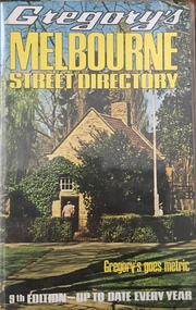
Book, Gregory's Publishing Company Pty Ltd, Gregory's Street Directory of Melbourne and suburbs and Metropolitan Road Guide, 1971
Street DirectoryRevised edition of Gregory's Directory including a series of road maps of Melbourne and its suburbs, newly extending to Lilydale, Mornington, Laverton, Deer Park, Epping, Diamond Creek, Olinda, Belgrave, and Doveton.non-fictionStreet Directorystreet directories - melbourne, gregory's street directories -
 Clunes Museum
Photograph, 1914
Premiership medallion 1914 Awarded to W E SharpBLACK AND WHITE PHOTOGRAPH OF COGHILL'S CREEK FOOTBALL TEAM CIRCA 1914, 13 PLAYERS STANDING 5 PLAYERS KNEELING IN FRONT W.E. SHARP 2ND FROM LEFT IN CENTRE ROW (SLEEVELESS)coghill's creek football team, w e sharp, premisership team 1914 -
 Bendigo Historical Society Inc.
Slide - DIGGERS & MINING. THE GOLD ERA, c1850s
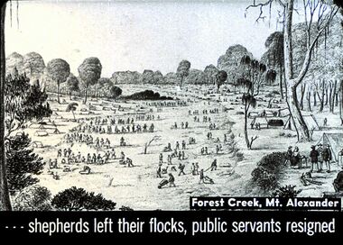
BHS CollectionDiggers & mining. The gold era. - - - shepherds left their flocks, public servants resigned. Slide shows men travelling through Forest Creek, Mt. Alexander. Markings 7 994.031 GOL:5.hanimounteducation, tertiary, goldfields -
 Chiltern Athenaeum Trust
Photograph - Gum Leaf, Alfred Eustace
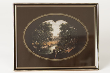
This colour photograph of a gum leaf painting shows one of the many landscapes done by the well-known self-taught Australian artist Alfred William Eustace (1820-1907). A.W. Eustace, an Australian artist and taxidermist, was born in Berkshire, England, where he was an assistant gamekeeper to the Earl of Craven at Ashdown Park. He migrated to Australia with his wife and children in 1851 and worked on the Ullina and Eldorado Runs on the Black Dog Creek at Chiltern, which was in excess of 50,000 acres of grazing land. A.W. Eustace was employed as a shepherd by Jason Withers and while tending his flocks in the solitude of the bush, Eustace turned his attention to painting and music to while away the long and weary hours. He endeavoured to capture the spirit of the bush painting on board, canvas or tin plate, but as these materials were not always readily available he then started painting on large round eucalyptus leaves from the White and Red Box trees that grew around about him. About 1856 he painted a small picture of the famous Woolshed goldrush and during the next few years became well known in North-East Victoria. John Sadlier, a police officer stationed at Beechworth said that Eustace painted 'some really exquisite scenes. He was of an easy-going dreamy temperament, a student of nature only, despising the works of men. Unfortunately his drawings were on eucalyptus leaves, the largest and roundest he could find and not on canvas, and no doubt have all perished long ago.' In 1876 the Melbourne Age newspaper reported, 'Eustace’s celebrated paintings on gum leaves are again attracting attention,…Mr Eustace is an elegant artist…he seems without effort to catch the colour and spirit of Australian scenery…' In 1864 A.W. Eustace held an Art Union in Albury, and again in 1884 in Ballarat. He exhibited at the Victorian Academy of Arts in 1877 and also held an exhibition of gum leaf paintings at Stevens Gallery, Melbourne in 1893. By 1896 he was receiving orders from heads of states in Europe, with his works acknowledged by Queen Victoria, Emperor Frederick of Germany and the Czar of Russia, as well as the Governors of New South Wales and Victoria. His paintings reflected his ability to paint the sky in his realistic style which is still noted by art critics of the day. A.W. Eustace was also a skilful taxidermist. The collection of birds and animals that can be seen at the Beechworth Museum are examples of his taxidermy skill. When not doing his work, painting or taxidermy, he regularly contributed letters and verse to the Chiltern newspaper, The Federal Standard. A book of verse in his hand writing was presented to The Athenaeum Trust by the Boadle family. In the 1870’s he became interested in spiritualism often being involved in lively debate at lectures and séances. Alfred William Eustace died in 1907 and is buried in the Chiltern New Cemetery with his wife Sarah and one of his daughters, Elizabeth.Colour photograph of an oil painting on gum leaf by Alfred Eustace. Landscape featuring a deep creek surrounded by thick bushland displayed against dark brown backing paper which has a gilt oval surround to highlight the painting. Under glass, in a gold and dark brown metal frame.Sticker on back: 189. (the original registration number)alfred eustace, gum leaf painting, landscape -
 Falls Creek Historical Society
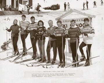
Photograph - Australian Olympic Team 1964
Ross Milne grew up on his family's tobacco property in Myrtleford, Victoria and started skiing at Falls Creek when he was 13. He went on to win the North-Eastern District Ski Association (NEDSA) Junior Championships for three years in a row. In 1961 Ross was a member of the Australian team which competed against New Zealand in the Inter-Dominion Championships. In 1963, he won the Downhill and Alpine Combined title at the Australian Championships, while placing second in the Grand Slalom event. Ross Milne was selected in the Australian team that participated in the 1964 Olympic Winter Games at Innsbruck, Austria. A few days before the opening of the Games, on 25 January 1964, he tragically lost his life when he crashed into a tree during a training run for the Men's Downhill. He was only 19 years of age. This item is significant because it shows the Olympic Team at Falls Creek and features Ross Milne who died tragically in a training run in Innsbruck, Austria shortly after this photo was taken.A mounted black and white photograph of the Australian Olympic team standing in front of the Falls Creek Ski School sign as well as an article "Ski Champion at 18" from Australian Women's Weekly Wed 9 Oct 1963. The image was taken while the team selected to represent Australia at the 1964 Winter Olympics at Innsbruck, Australia were in training. Left to right: Christine Smith, Simon Brown, Sigi Haberzettl (Coach), Judy Forras, John Wagner (Manager), Peter Wenzel, Peter Brockhoff, Ross Milne.australian winter olympians, winter olympics 1964, ross milne -
 Eltham District Historical Society Inc
Slide - Photograph, Wet Gully, Diamond Creek, c.May 1988
Wet Gully (local name) between Eltham and Diamond Creek, bound by Reynolds and Lorimer roads, Diamond Creek, May 198835mm colour positive transparency (2 of 36) Mount - Kodak KodachromeProcess Date MAY 88Mdiamond creek, lorimer road, reynolds road, wet gully -
Stawell Historical Society Inc
Archive, Pleasant Creek Special School (Stock List Books), 1937 - 1955
Former Pleasant Creek Hospital site. Sometimes referred to as Pleasant Creek Special School and sometimes Pleasant Creet Training Centre.Pale Grey Pater, some are red Boundstawell, education -
 Glenelg Shire Council Cultural Collection
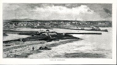
Artwork, other - Illustration Portland Barton's Beach, n.d
Illustration. Taken and cut from a book. Black and White rectangle image on off white paper. Portland from Barton's Beach, looking north west. Panoramic view in background of Portland's town with original buildings. All Saints Catholic Church with spire recognisable. Pier in the Middle right with various structures and a docked ship with sails. Bottom left 3 people launching two canoes at the beach. Wattle Creek or Salt Creek with bridge structure on the middle left. Front: 'VIEW OF PORTLAND' - printed, bottom frame. Signature 2cm in from the left corner of the frame 'CALVERT. SS'portland, bartons beach, portland bay -
 Bendigo Historical Society Inc.
Newspaper - JENNY FOLEY COLLECTION: WARES
Bendigo Advertiser ''The way we were'' from 2000. Wares: an array of products sits outside the Bendigo Pottery in 1930. The pottery was established in 1857 on the left bank of Bendigo Creek, near the junction of Eaglehawk Creek, and was brought to prominence in 1968 when then owner George Guthrie was awarded two gold medals at the Intercolonial Exhibition in Melbourne. By 1870, the pottery was producing a wide range of items, from stoneware pipes to spirit bottles. The pottery still operates at Epsom today. The clip is in a folder.newspaper, bendigo advertiser, the way we were -
 Bendigo Historical Society Inc.
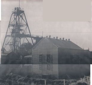
Photograph - CENTRAL DEBORAH GOLD MINE
Black and white photo. Central Deborah Gold Mine, corner Violet and Creek Streets, Bendigo. 1939-1954. Shaft 1347 feet deep. Gold extracted 29,460 ounces. This mine was purchased by the Bendigo City Council to be retained as a Mining Museum. Markings/Inscriptions: Central Deborah Mine. Corner Violet and Creek Streets. 1939-1954. Shaft 1347 feet. Gold 29,460 ozs. This Mine has been purchased by the Bendigo City Council to be retained as a Mining Museum.organization, business, central deborah gold mine -
Bendigo Historical Society Inc.
Document - BENDIGO MINES AND MANAGERS
Thirty five page document, alphabetic list of mines with names of managers. No dates given. Mine in document 'Back Creek Quartz Mining Company, Moran, M. For example the Back Creek Quartz Mining Company ' dated at Sandhurst this 17th day of October, 1871. Matthew Moran Manager, Witness Andrew W. Moran. (Victorian Government Gazette 67, Date: Friday, October 20th 1871) Mines appear to be those listed in the early 1870's and published in the Government Gazette 0bendigo, mining, mines and managers -
 Bendigo Historical Society Inc.
Photograph - RAILWAYS COLLECTION: PHOTO OF A SKETCH OF 'JACKSON CREEK VIADUCT OPENING
Railways collection -photo of a sketch of 'Jackson Creek Viaduct Opening (Courtesy ARHS Vic Division Inc.)'. The Jackson Creek Viaduct is a bridge about 24 miles from Melbourne and is 80 feet high being constructed of Footscray Bluestone piers and abutments and wrought iron girders. The girders were made in England and delivered to the colony by the time the the piers were ready to receive them. The laying of the foundation stone of this viaduct marked the opening of the line to Sunbury on 13 January 1859.photo, 'jackson creek viaduct -
Bendigo Historical Society Inc.
Map - TARNAGULLA : COUNTY OF BENDIGO, 1959
Map. Tarnagulla, County of Bendigo, County of Gladstone, Inglewood, Glenalbyn, Kingower, Moliagul, Painswick, Waanyarra, Laanecoorie, Woodstock, Derby, Loddon River, Dunolly to Inglewood Railway, Laurie Railway Station, Township of Tarnagulla, Tarnagulla Rifle Range, Township of Llanelly, Arnold Railway Station, Bullabul Creek, Kangderaar Creek, Township of Newbridge. By authority A.C. Brooks, Government Printer, Melbourne. Drawn and reproduced at the Department of Lands and Survey, Melbourne, 1959. (number 117 in map cupboard 1)A.C. Brooks, Government Printer, Melbourne.map, bendigo, tarnagulla -
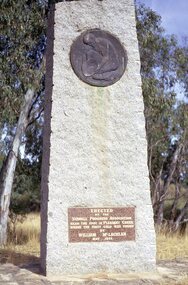 Stawell Historical Society Inc
Slide, Ian McCann, Gold Memorial Pleasant Creek 1971
Monument to commemorate where gold was first found in StawellOn Insert near base of Monument. Erected by the Stawell Progress Association Near the spot in Pleasant Creek where the first Gold was found By William McLachlan May 1853monuments, gold -
 Ringwood and District Historical Society
Map, Plan of Country Lands in the Parishes of Nunawading Ringwood and Scoresby - circa 1855
Blueprint copy of Survey Map detailing original Selectors' names and property locations. List of Parish map references including property bearings, distances in Links, and markings on trees. Descriptive remarks include areas marked "Farmer's Common", "Poor soil thickly/moderately timbered with stringy bark", and location of water and firewood reserves."Surveyed and plotted by N.M. Bickford, Superintendant of Mr. Hodgkinson's Field Party". "The land comprised in this survey is of inferior quality, moderately undulating, and thickly wooded. It is watered by Dandenong Creek and Deep Creek." Inset map showing location of (*proposed) cemetery on southern corner of Lillydale Road from Melbourne and Sawmill Road, later Mount Dandenong Road. (*Cemetery did not eventuate.) -
 Eltham District Historical Society Inc
Negative - Photograph, J.A. McDonald, Eltham-Diamond Creek Road, May 1958
Wing pier Eltham abutment Bridge construction Eltham-Diamond Creek road over the Diamond Creek (Wattletree Road), Eltham, May 1958Record of various Shire of Eltham infrastructure works undertaken during the period of 1952-1962 involving bridge and road reconstruction projects, sometimes with Eltham Shire Council Project Reference numbers quoted. It was during this period that a number of significant improvements were made to roads and new bridges constructed within the shire that remain in place as of present day (2022). In many situations, the photos provide a tangible visible record of infrastructure that existed throughout the early days of the Shire. The album was put together by or under the direction of the Shire Engineer, J.A. McDonald.infrastructure, shire of eltham, 1958-05, bridge construction, wattletree road bridge -
 Lorne Historical Society
Photograph, Grassy Creek C.R.B. Camp
Photo of the Grassy Creek C.R.B site looking towards Aireys Inlet. Top left hand corner - the first tents were the gangers next were the mine and the third the timekeepers. The camp site is in the valleyg.o.r.; c.r.b. construction camp sites; gangers; mine; timekeeper; grassy creek; -
Glenelg Shire Council Cultural Collection
Photograph - Photograph - Fawthrop Lagoon, Portland Victoria, n.d
Black and white photo. Original photo 7731 7731 - Black and white photo of the causeway across Wattle Creek end of Fawthrop Lagoon. Lagoon visible on left. Taken from bottom of Magazine Hill.Back: '56' in pencil -
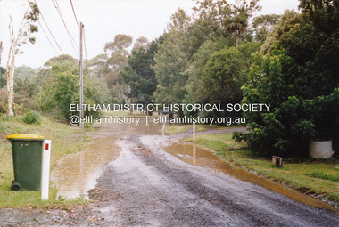 Eltham District Historical Society Inc
Photograph, Flooding of Diamond Creek, Eltham, Feb 2005, 2005
Two colour photographs of the Diamond Creek floodwater; two at Souter Street and one looking north across the Eltham Rugby Union Football Club oval towards the Bridge Street bridge, Feb 2005eltham, diamond creek, floods, souter street, bridge street -
 Federation University Historical Collection
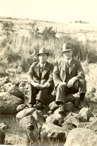
Photograph - Black and White, Frank Wright and Friend, circa late 1920's
Frank Wright was a renown resident of Smeaton, where he was born. He lived at Laura Villa, and attended Smeaton State School. His father William was a gold miner and his mother's name was Sarah. Their family won many singing and instrumental awards. Frank was tutored by Percy Code and was awarded a gold medal for the highest marks in the ALCM examinations in the British Colonies at the age of seventeen years. He became the Australian Open Cornet Champion by the age of eighteen. A year later, Frank conducted the City of Ballarat Band, and later the Ballarat Soldiers’ Memorial Band. He formed the Frank Wright Frisco Band and Frank Wright and his Coliseum Orchestra. These bands won many South Street awards, and Frank as conductor won many awards in the Australian Band Championship contest. In 1933 Frank Wright sailed to England to conduct the famous St Hilda’s Band and was later appointed Musical Director of the London County Council, where he organized many amazing concerts in parks, in and around the London district. He was made Professor of Brass and Military Band Scoring and conducted at the Guildhall of Music and Drama. Frank was often invited to adjudicate Brass Band Championships around Europe, in Australia, including South Street and in New Zealand. The Frank Wright Medal at the Royal South Street competition is awarded to an individual recognized as making an outstanding contribution to brass music in Australia.Black and white photograph of two men dressed in suits and hats, sitting on rocks beside a creek in a grassy paddock, with a post a wire fence in the background. The man on the left is Frank Wright. The man on the right is unknown.Printed on back - SELOfrank wright, ballarat, cornet, conductor, smeaton -
 Bendigo Historical Society Inc.
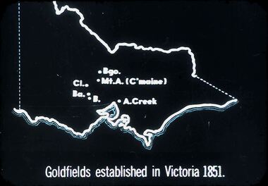
Slide - DIGGERS AND MINERS. DIGGERS AND MINERS, c1851
Diggers and miners. Diggers and Miners. Map of Victoria shows Bgo. Mt. A. (C'maine) Cl. Ba. B. A. Creek. Goldfields established in Victoria 1851. Markings: 11 994.5 WAL. Used as a teaching aid.hanimounteducation, tertiary, goldfields -
 Bendigo Historical Society Inc.
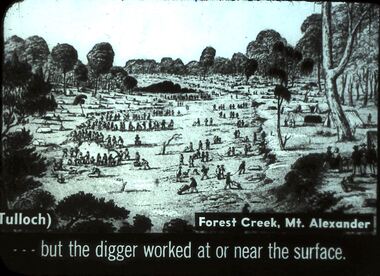
Slide - DIGGERS AND MINERS. DIGGERS AND MINERS, 1850s
Diggers and miners. Diggers and Miners. (Tulloch) Forest Creek, Mt. Alexander . . . But the digger worked at or near the surface. Picture shows lots of diggers at work. Markings: 4 994.5 WAL. Used as a teaching aid.hanimounteducation, tertiary, goldfields -
 Bendigo Historical Society Inc.
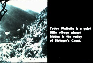
Slide - DIGGERS & MINING. DIGGERS AND MINERS, 1850s
Diggers & Mining. Diggers and Miners. Today Walhalla is a quiet little village almost hidden in the valley of Stringer's Creek. Photo shows the town in the valley. Markings: 60 994.5 WAL. Used as a teaching aid.hanimounteducation, tertiary, goldfields -
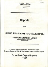 Bendigo Historical Society Inc.
Book - REPORTS OF THE MINING SURVEYORS AND REGISTRARS 1885 - 1896, 1997
Reports of the Mining Surveyors and Registrars. Sandhurst (Bendigo) District. 13 various Reports from 1885 to December 1887 Greytown Report of 1896 and the Yankee Creek Goldfields Report. Facsimile of Original Reports 1997.goldfields, mining reports -
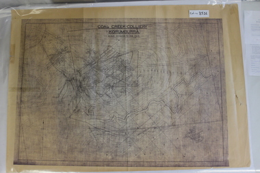 Coal Creek Community Park & Museum
Map of Mine and Details, Coal Creek Colliery Korumburra
8516.1 - Schematic/map of coal creek mine workings, also detailing number surface features such as topographic heights, roads, railways, boreholes, etc. No Legend. Most information seems to be printed, with topography drawn on. -
 Clunes Museum
Photograph
PICTURED, L -R HARRY PICKFORD, HARRY ROBINSON, BILL ROBINSON SENR. COLIN DRIFE, FRANK CARROLAN, JACK KIERCE, AND GEORGE DRIFE. ORIGINAL PHOTOGRAPH OWNED BY MR. MICHAEL KIERCE.PHOTOCOPY OF PHOTO OF OPENING OF BRIDGE OVER MOUNT CREEK CIRCA 1941, SHOWING HARRY PICKFORD, HARRY ROBINSON, WILLIAM ROBINSON SNR., COLIN DRIFE, FRANK CARROLAN, JACK KIERCE, GEORGE DRIFE.local history, photography, photographs, bridges -
Whitehorse Historical Society Inc.
Postcard - Illustration, Heidelberg School
Folio of coloured postcards of artists paintings from the Heidelberg School. The Heidelberg School set up tents in 1885 on land belonging to David Houston on Gardiner's Creek. Included is a history on each artist and painting.heidelberg school, davies, david, conder, charles, phillips, fox emanuel, mccubbin, frederick, roberts, tom, streeton, arthur, sutherland, jane, withers, walter, alston, alby, box hill artists camp -
Whitehorse Historical Society Inc.
Map, Environment effects statement, 1/03/1979 12:00:00 AM
Diamond Creek-Ringwood study: Planning Scheme reservations and zones with recommended concept.Diamond Creek-Ringwood study: Planning Scheme reservations and zones with recommended concept. City of Nunawading: section north of Canterbury Road. Scale 1:25,000 metric. Map B with drafting ref. no. 145Diamond Creek-Ringwood study: Planning Scheme reservations and zones with recommended concept. city of nunawading, land use, melbourne metropolitan planning scheme -
 Lakes Entrance Regional Historical Society (operating as Lakes Entrance History Centre & Museum)
Photograph, Bennett, Vera, 1989
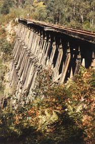
Date made June 1989|Two photographs taken by Vera Bennett| One photograph taken by Keith Scarce|Six photographs all similar views of trestle bridgeColour photograph of the trestle railway bridge over Stoney Creek, near Nowa Nowa, showing bridge in intact condition soon after the cessation of services from Bairnsdale to Orbost. Nowa Nowa Victoriabridges, transport -
 Lakes Entrance Regional Historical Society (operating as Lakes Entrance History Centre & Museum)
Photograph, 1993
Black and white photograph two students Rae Robins Swift Creek and Wendy Whitford Orbost at TAFE Outreach taking part in Media Skills workshop, East Gippsland Access Project. Gippsland Victoriaeducation