Showing 11164 items matching "planning "
-
 Ringwood and District Historical Society
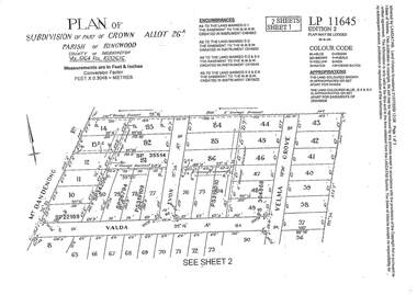
Document - Subdivision Plan, LP11645 Part of Crown Allotment 26A, Parish of Ringwood, County of Mornington Vol 5164 Fol 1032616 - 1926
LANDATA Land Victoria 2-sheet plan printout dated 2009Sheet 1 includes Mount Dandenong Road, Valda Avenue and Velma Grove, Ringwood East. Additional markings include SP35514, SP22189, SP34206, SP35514, SP26794, PS319109, PS319010 and PS304868. Sheet 2 includes Mount Dandenong Road, Valda Avenue, Mirabel Avenue and Velma Grove, Ringwood East. Additional markings include SP26430, SP25320, PS341575, PS319110, PS319010, LP48415, SP22732, SP25844, PS304936 and PS304937. -
 Ringwood and District Historical Society
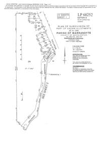
Document - Subdivision Plan, LP113220 Part of Crown Allotments 35 & 39B, Parish of Warrandyte, County of Mornington, Vol 6421 Fol 183 & 184 - 1965
LANDATA Land Victoria 2-sheet plan printout dated 2009Sheet 1 includes Kalinda Road, Ringwood. Additional markings include LP113117. Sheet 2 includes Kalinda Road and Maroondah Highway, Ringwood. Additional markings include LP86253. Both sheets include location of Drainage and Sewerage Reserve along Mullum Mullum Creek. -
 Ringwood and District Historical Society
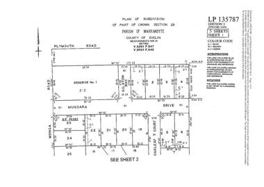
Document - Subdivision Plan, LP135787 Part of Crown Section 23, Parish of Warrandyte, County of Evelyn, Vol 9293 Fol 947 and Vol 9503 Fol 640 - 1984
LANDATA Land Victoria 3-sheet plan printout dated 2007Sheet 1 includes Wonga Road, Mundara Drive, Gilston Way and Oakleaf Court, Ringwood. Additional markings include SP25252. Sheet 2 includes Wonga Road and Oakleaf Court, Ringwood. Sheet 3 includes Wonga Road, Wyndarra Court and Gem Close, Ringwood. -
 Ringwood and District Historical Society
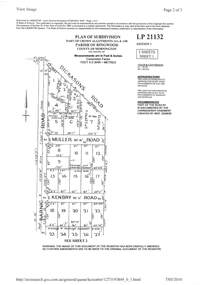
Document - Subdivision Plan, LP21132 Part of Crown Allotment 14A & 14B, Parish of Ringwood, County of Mornington Vol 4929 Fol 657 - (Undated, circa 1920s/30)
LANDATA Land Victoria 2-sheet plan printout dated 2010.Sheet 1 includes Dickasons Road, Barnic Road, Muller Road and Kenbry Road, Heathmont. Sheet 2 includes Barnic Road and Possum Lane, Heathmont. Additional markings include LP83779. -
 Ringwood and District Historical Society
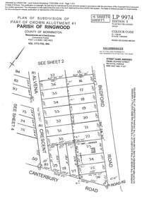
Document - Subdivision Plan, LP9974 Part of Crown Allotment 41, Parish of Ringwood, County of Mornington Vol 1773 Fol 464 - 1924
LANDATA Land Victoria 4-sheet plan printout dated 2009Sheet 1 includes Alvena Crescent, Bedford Road and Canterbury Road, Heathmont. Additional markings include RP16869. Sheet 2 includes Alvena Crescent and Bedford Road, Heathmont. Additional markings include PS318390 and CP161633. Sheet 3 includes Bedford Road, Alvena Crescent and Royal Avenue, Heathmont. Additional markings include RP454. Street name amended from Leonard Street to Royal Avenue Vide Gaz 1962 P.427. Sheet 4 includes Alvena Crescent, Royal Avenue, Coleman Street and Canterbury Road, Heathmont. Additional markings include SP27861, PS305057, RP10566, SP34722 and LP116573. -
 Ringwood and District Historical Society
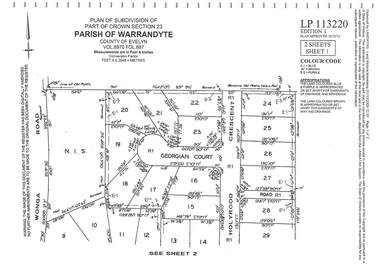
Document - Subdivision Plan, LP113220 Part of Crown Section 23, Parish of Warrandyte, County of Evelyn Vol 8970 Fol 687 - 1975
LANDATA Land Victoria 2-sheet plan printout dated 2009Sheet 1 includes Wonga Road, Holyrood Crescent and Georgian Court, Ringwood. Sheet 2 includes Wonga Road, Holyrood Crescent and Stonington Place, Ringwood. -
 Bendigo Historical Society Inc.
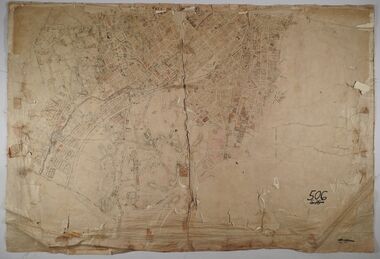
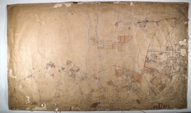
Map - SANDHURST (PART), No date visible
Map: Parish plan showing the Southwestern corner of Sandhurst to the Municipal boundarymap, bendigo, parish plan, sandhurst -
 Bendigo Historical Society Inc.
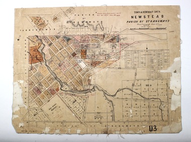
Map - NEWSTEAD, 28/07/1874
Map: Newstead Town and Suburban Lots, Parish of Strangways. Parish planmap, township, newstead -
 Bendigo Historical Society Inc.
Map - SANDHURST ? SHEET 5, 29/10/1879
Map: Parish plan showing area Northwards from Kangaroo Flatmap, bendigo, parish plan, parish of sandhurst, kangaroo flat -
 Melbourne Tram Museum
Archive (Series), Melbourne & Metropolitan Tramways Board (MMTB), Hawthorn Road Extension - East Brighton, 1935 to 1940
Melbourne and Metropolitan Tramways BoardRecord of correspondenceLetters in date orderDetails correspondence both internal and external with Councils and others about the construction of tramways along Hawthorn Road to East Brighton and beyond to Moorabbin Railway Station or along North Road. Includes estimates, notices to Passengers, fares for the extension south during 1937, notices to crews, staff working of the single line, and passenger figures.tramways, new track, extensions, correspondence, hawthorn road, east brighton, safe working, new tramwaystramways, new track, extensions, correspondence, hawthorn road, east brighton, safe working, new tramways -
 Bendigo Historical Society Inc.
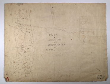
Map - LODDON CREEK, Circa 1860
Map: Plan of agricultural lands upon the Loddon Creek in the parish of Shelbournemap, bendigo, agricultural lands, agricultural lands, loddon creek, shelbourne -
University of Melbourne, Burnley Campus Archives
Plan, Phil Tulk, Building 9 and Surrounds Landscape Proposal, 1999
Coloured plan by P. Tulk for AMRAD Corporation 13/8/99phil tulk, buildings, amrad corporation, landscape design -
University of Melbourne, Burnley Campus Archives
Plan, Horticultural & Experimental Garden in the Survey Paddock Richmond, 1862
Plan of site with area drawn in. From Office Dept. of Natural Resources.Handwritten on original: "To accompany letter from the Hon. Sec. of the Horticultural Society of Victoria to the Hon. The President of the Board of Land Works. A. Purchas, C.E. 9 October 1862 R 19 A1." and "Memo: The trees to be planted 50 feet apart in each row. AP"burnley, horticultural society of victoria -
Clunes Museum
Plan - TITLE PLAN, DEPARTMENT OF LANDS AND SURVEY, TOWNSHIP OF GLENGOWER
1 PAGE PLAN OF THE TOWNSHIP OF GLENGOWER COUNTY OF TALBOT (11 COPIES) DRAWN AND REPRODUCED AT THE DEPT. OF LANDS AND SURVERY MELBOURNE VICTORIA NOVEMBER 1954 PRICE 2/-parish of glengower, title plan of glengower -
 Kew Historical Society Inc
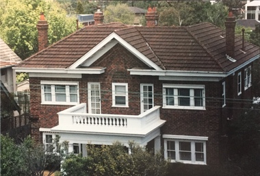
Photograph - 264 Cotham Road, 1988
The dwelling is representative of the development of the Georgian Revival style in the 1920s and 30s and its popularity amongst the upper-middle classes as a result of the work of William Hardy Wilson and Professor Leslie Wilkinson. It is of importance as a fine and largely intact designer/builder example of the Georgian Revival style, with American Georgian Revival influences. The dwelling embodies the principal characteristics of the style. American Georgian Revival influences are noted in the deep eaves with modillions, central broken pediment, brick quoins and presentation of the central porch. The garden wall, with arched opening, in the side setback appears to be an early or original landscape feature, based on the comparable brick work detail construction with that of the house. Considering this, it is the only early landscape feature extant which assists in providing some understanding of the original landscape layout of the property. (Criteria D and E) (Boroondara Planning Scheme)Colour photographic positive of 264 Cotham Road, Kew. The residence was constructed in 1931 for the Howitt family. 264 Cotham Road, Kew (HO813) is an individually listed building of significance under Amendment C294 of the Boroondara Planning Scheme. 264 cotham road -- kew (vic.) -
 Bendigo Historical Society Inc.
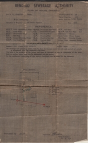
Document - JOAN LEVERSHA COLLECTION: BENDIGO SEWERAGE AUTHORITY PLAN HOUSE DRAINAGE
Bendigo Sewerage Authority plan of house drainage for Mr Douglas Dean, situation of property: weatherboard dwelling, 26 Bolt Street, Long Gully. Drainage plan no.35, Detail plan No. 134, retic. area No. long Gully. fee 7/6. Scale 40 feet to 1 inch. Dated 30/08/1954.organisation, government, bendigo sewerage authority -
University of Melbourne, Burnley Campus Archives
Plan, Jacqueline Fraser, The Chivers House 34 Finlayson Street Malvern East, 1991
(1) Jacqueline Fraser - Site Inventory and Analysis dated 5.11.91, Conceptual Design dated 1.11.91, Planting Plan and Section Elevation dated 8.11.91. Scale 1:100. (2) Troy Watchorn - Site Analysis and Inventory, Concept Plan, Planting Plan, Section Elevation, dated 14.11.1991. Scale 1:100. (15 sheets)jacqueline fraser, troy watchorn, landscape design, malvern -
Port Melbourne Historical & Preservation Society
Archive - File, Ewan Ogilvy's Bayside Papers, Box Two: Bayside Local Action Group Correspondence Ministerial Statements etc, 1987
Ewan Ogilvy, former Melbourne Councillor and also of Community Services Victoria, Inner Urban Ministerial Advisory Committee and Uniting Church's Centre for Urban Research and Action (CURA), was instrumental in social justice approaches to town planning. He and CURA's Social Justice and the City Project funded Port Melbourne community groups protesting against the SCDC development in 1987. His files were presented to the Society in May 2001 on his preparation for leaving Victoria.From Ewan OGILVY's chronologically organised 'Bayside Papers' relating to the proposed development of Port Melbourne industrial land in the late 1980s, bound file: Bayside Development Action Group records, items from Bayside Open Planning Forum August 1992 (ref #1474, 1505), various press reports, flyers etc.All items signed 'Ewan Ogilvy'town planning, town planning - proposals shelved - bayside, public action campaigns, environmental issues, public housing, missions to seamen, centre for urban research and action, sandridge city development co pty ltd, scdc, linton r lethlean, barry pullen, ewan ogilvy -
Port Melbourne Historical & Preservation Society
Document, Ewan Ogilvy's Bayside Papers, Box Three: Notice of Referral to Administrative Appeals Tribunal, 1987
Ewan Ogilvy, former Melbourne Councillor and also of Community Services Victoria, Inner Urban Ministerial Advisory Committee and Uniting Church's Centre for Urban Research and Action (CURA), was instrumental in social justice approaches to town planning. He and CURA's Social Justice and the City Project funded Port Melbourne community groups protesting against the SCDC development in 1987. His files were presented to the Society in May 2001 on his preparation for leaving Victoria.From Ewan Ogilvy's chronologically organised 'Bayside Papers' relating to the proposed development of Port Melbourne industrial land in the late 1980s: Notice of Referral to Administrative Appeals Tribunal May 1988; Mayor, councillors and Citizens of Port Melbourne vs Minister for Planning and Environment re EPS Amendment RL22; bound in blue fileSigned 'Ewan Ogilvy'town planning, town planning - proposals shelved - bayside, public action campaigns, environmental issues, public housing, missions to seamen, ewan ogilvy, centre for urban research and action, sandridge city development co pty ltd, scdc, linton r lethlean, barry pullen - mlc -
 Federation University Historical Collection
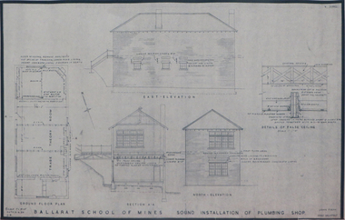
Plan (copy), Ballarat School of Mines Plumbing Building, 1954
.1) Ballarat School of Mines Sound Installation of Plumbing Shop, by architect John Firth, 1954 .2) Plan and sections of the proposed Scheme - conversion of Ballarat School of Mines Clay Mill Building to Fluid Mechanics Laboratory, by architect John E. Dixon, 1962 .3) Plan for Ballarat School of Mines New Sanitary Accomodation, 1967 .4) Plan for Ballarat School of Mines Extension to Existing Workshop by architect Percy E. Everett. The plan includes the former Ballarat Supreme Courtjohn firth, percy everett, john e. dixon, ballarat school of mines, clay, ceramics, plumbing, buildings, architectural plan -
Federation University Historical Collection
Book, University of Ballarat Interim Strategic Plan, 1997, 1989
A4 book compiled by the University of Ballarat Financial and Resource Services Branch. Appendices include: * Statutory requirements for Financial & Planning Services Branch * Halls of Residence Strategic Plan * Campus Amentities Strategic Plan * Finanace Database Volume Statistics * Client Survey - PLanning Services and Budgeting Services * Recent In-House I.T. Development * Processes to be investigated/Introduced Tables include: * Staffing by level, gender and age * Fianancial & Resource Services Budget, 1997 * Fianancial & Resource Services Budget, 1998 strategic plan, fiancial planning, robert hook, mission, vision, values, staffing, information technology, halls of residence, student accomodation -
 Melbourne Tram Museum
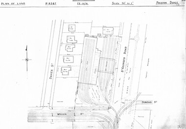
Drawing, Melbourne & Metropolitan Tramways Board (MMTB), "Preston Depot", c1938
Set of three photocopied plans or drawings on A3 sheets of the "Preston Depot" - c1938, later to become Thornbury Depot .1 - P8387 - Plan of Preston depot including adjacent properties, St Georges Road and entry into Preston Workshops - 6-4-1938. .2 - unnumbered - Plan of depot, St Georges Road, Yan Yean Pipe track, Millers St - dated 12-10-1939. .3 - P8388 - detail plan of depot, offices and open car shelter - c1938.trams, tramways, drawings, depots, property, preston depot, thornbury depot -
 Bendigo Historical Society Inc.
Plan - MARKS COLLECTION: PLAN OF COLIBAN CHANNEL
Plan, hand drawn on waxed paper: Coliban Channel through centre of plan. Written on LH side right of passage over 1 1/2 chains from Melbourne Road Written in red rail water may be returned into channel here VWS fence 3682 drawn in dotted line. Head of drop to bottom of channel drawn inside elevation view on bottom RH corner of plan. Plan also shows Railway reserve, machinery site (un-named)plan, bendigo, coliban channel -
 Ringwood and District Historical Society
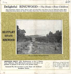
Pamphlet, Land Sale Brochure, Bestpart Estate, Ringwood - circa 1925
Twelve page land sale brochure including photographs, subdivision features and local facilities. Additional flyer with conditions of sale and prices for estate blocks.Subdivision plan includes Bedford Road, Greenwood Avenue, Caroline Street, Wilanna Street, Henry Street, Haig Street -
 Ringwood and District Historical Society
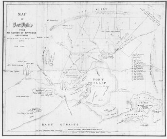
Photograph, Map of Melbourne & Vicinity - 1853. Survey of Port Phillip. Plan in Bonwick's "Settlement of Port Phillip"
Catalogue card reads, 'Map of Melbourne & Vicinity - 1853. Survey of Port Phillip. Plan in Bonwick's "Settlement of Port Phillip"'. -
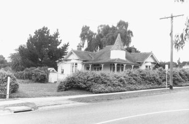 Ringwood and District Historical Society
Photograph, Sole remaining house in Adelaide Street, Ringwood 1987
Black and white photograph of house.Written on back of photograph: "9/1/87 - Sole remaining house in Adelaide Street. Not included in the plans for redevelopment of Eastland." -
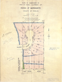 Ringwood and District Historical Society
Document - Real Estate Folder, Savernake Estate, Ringwood, Victoria - Stage two - circa 1967
Plan of Subdivision PS79692, Part of Crown Allotment 31A Parish of Warrandyte, and advertisement for sale of residential allotments with map showing layout of Stage 2 of subdivision. Typewritten details for first and second release of Lots 10 to 16 with Terms of sale, stapled to two advertising flyers featuring map of estate showing Lots 1 to 20 on Evelyn Road, Cameron Road, Klead Court, and San Remo Road. Green slip included dated 6 July 1979 showing description of property at Lot 14 (no.4) San Remo Road, vendor - Judith Margaret Love and Lindsale Stephen Love, Cherry Tree Downs, Tarwin Lower 3456. Phone 056635390 Bus 056787203.Agent - C.E. Carter & Son, R.E.S.I. 126 Whitehorse Road, Ringwood. Telephones: 8706024, 8706830, 8702519, A.H.: 7233298, 8782648. Subdivision Plan stamped Donald Cameron Consultants Pty. Ltd., Consulting Engineers, 472 Bourke Street Melbourne - 67-2602. -
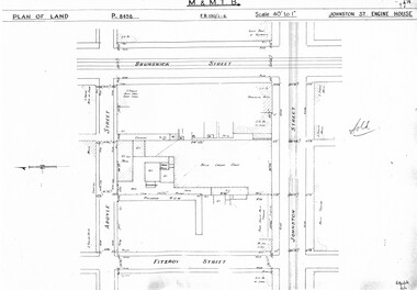 Melbourne Tram Museum
Drawing, Melbourne & Metropolitan Tramways Board (MMTB), "Johnston St Engine House", "Northcote Engine House", "Richmond Engine House", c1938
Set of four photocopied plans or drawings on A3 sheet of the "Johnston St Engine House", "Northcote Engine House" and "Richmond Engine House", c2/1938. .1 - Sheet 1 - P8498 - Plan showing land and surrounding streets for the "Johnston St Engine House" .1 - Sheet 2 - P8499 - Plan showing the layout of the engine house. Has a note sheets 1 and 2 that it has been sold .2 - P8506 -Plan showing land and surrounding streets for the "Northcote Engine House" - 2 copies held. .3 - P8607 - Plan showing Richmond Engine House and adjacent streets with sub-station next doortrams, tramways, drawings, depots, property, cable trams, winding houses, johnston st, northcote, richmond, hoddle st, bridge rd -
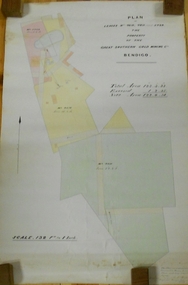 Bendigo Historical Society Inc.
Plan - MARKS COLLECTION: LEASE PLANS GREAT SOUTHERN GOLD MINE BENDIGO
Plan on heavy paper, tightly rolled. On top of plan "Plan of Leases 5429, 4810, 4811 and 5429", The Property of the Great Southern Gold Mining Co. Bendigo' \Total area123 acres, 3 roods, 33 perches, excised, nett area 122, 0. 38. On bottom '32 feet to one inch' and 'This plan was devised from Government Mining Lease Plans and from actual survey' Signed E.F Brown, certificated mining and authorised surveyor 25/6/87' Leases No. 5429 and 4810 details location of shaft, tramway, battery, engine house and boiler. Large mining dam outlined.bendigo, mining, great southern gold mine -
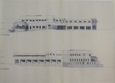 Federation University Historical Collection
Plans, Six plans for the Central Highlands Regional Library Services Headquarters, and Ballarat City Library, 1993
Six printed architectural plans on paper: .1) .2) .3) Plan levels 1, 2, 3 .4) Sections aa-bb .5) North and south elevations .6) East and west elevationsarchitecture, central highlands, central highlands regional library, ballarat city library, plans