Showing 3220 items
matching road map
-
 Whitehorse Historical Society Inc.
Map, Proposed Mullum Mullum Park, 6/05/2008
Map produced by Parks Victoria.Map produced by Parks Victoria.Map produced by Parks Victoria.mullum mullum park, maps -
Whitehorse Historical Society Inc.
Map, Map of Nunawading, 1950?
... Whitehorse Historical Society Inc. 2-10 Deep Creek Road ...Map of the entire City of Nunawading: complimentary map issued by Frank Fisher & Co real estate agents, Blackburn.Map of the entire City of Nunawading: complimentary map issued by Frank Fisher & Co real estate agents, Blackburn.Map of the entire City of Nunawading: complimentary map issued by Frank Fisher & Co real estate agents, Blackburn.nunawading, map -
Whitehorse Historical Society Inc.
Pamphlet, Exploring your sanctuary, 2005
Long and short walks around Blackburn Lake Sanctuary, incl. map. Rev. ed. 2005.Long and short walks around Blackburn Lake Sanctuary, incl. map. Rev. ed. 2005.Long and short walks around Blackburn Lake Sanctuary, incl. map. Rev. ed. 2005.blackburn lake sanctuary, maps -
Whitehorse Historical Society Inc.
Document, 'Through her eyes', 2007
The Women's map of Melbourne City. Key dates, map, significant sites and services.The Women's map of Melbourne City. Key dates, map, significant sites and services. 2nd edThe Women's map of Melbourne City. Key dates, map, significant sites and services. melbourne, suffrage, women -
Whitehorse Historical Society Inc.
Map, Pocket guide to walking and wheeling in Whitehorse, 2008
Map showing walks, cycle tracks and off lead areas for dogs in Whitehorse.Map showing walks, cycle tracks and off lead areas for dogs in Whitehorse. Includes walking and cycling groups.Map showing walks, cycle tracks and off lead areas for dogs in Whitehorse. walking trails, bicycle paths, city of whitehorse -
Whitehorse Historical Society Inc.
Document, Bicentennial Leadlight Mural
Working drawings and cartoons used in the making of the Bicentennial Leadlight Mural installed in the Nunawading Arts Centre in 1988.Working drawings and cartoons used in the making of the Bicentennial Leadlight Mural installed in the Nunawading Arts Centre in 1988. Located on top of the Map CabinetWorking drawings and cartoons used in the making of the Bicentennial Leadlight Mural installed in the Nunawading Arts Centre in 1988.bicentennial leadlight mural, bi-centennial -
 Whitehorse Historical Society Inc.
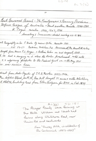
Map, Frank Ainger, 1873
Application by Frank Ainger for land in the Parish of Nunawading on Whitehorse Road near Mitcham Road. Also included are several references from other sources to Frank Ainger.ainger, frank, shire of nunawading, mitcham, land settlement -
 Whitehorse Historical Society Inc.
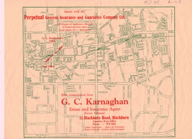
Map, Map of Mitcham, Nunawading and Blackburn, 1947
Map of Mitcham, Nunawading and Blackburn with compliments of G.C.Karnaghan, Estate and Insurance Agent of 15 Blackburn Road, Blackburn. Phone WX 1661 (4copies) Possibly 1947.g. c. karnaghan estate agent, perpetual general insurance and guarantee co. ltd., mitcham, nunawading, blackburn -
 Whitehorse Historical Society Inc.
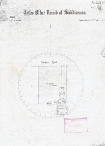
Map, Titles Office Record of Subdivision
Titles Office Record of Subdivisionclarkes road, blackburn, whitehorse road -
Whitehorse Historical Society Inc.
Document, Livermore's property, n.d
Hand drawn map of original Livermore home, Verona Street, Morack Road. See Photograph album.livermore family, city of nunawading, verona street, vermont south, morack road, vermont south -
Whitehorse Historical Society Inc.
Map, History of Nunawading, 1892
Map of the Shire of Nunawading from the Municipal Directory of 1892.shire of nunawading -
Whitehorse Historical Society Inc.
Document, Municipal Reserve, n.d
Hand drawn map of blocks and municipal reserve off Anjaya Court, Blackburn.parks and reserves, anjaya court, blackburn -
Whitehorse Historical Society Inc.
Document, Eastern suburbs map, n.d
... Whitehorse Historical Society Inc. 2-10 Deep Creek Road ...Hand drawn map of eastern suburbs and railways of eastern suburbs showing heights above sea levelrailways, maps -
Whitehorse Historical Society Inc.
Map, Map of City of Nunawading, n.d
Hand drawn map of City of Nunawading showing heights above sea level.city of nunawading, maps -
 Whitehorse Historical Society Inc.
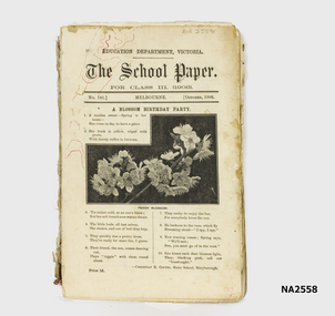
Book, The School Paper for Class 111 - Education Dept Vic, 1908 - 1909
According to an accompanying from donor, these school papers were used bt H.Tuck at Vermont State School -1918.This 'book' appears to be a series of journals or magazines bound together with a home made twisted cloth spine and hand stitched. Photo of peach blossom on front cover of issue for October, no. 141. Gothic Script Title. (see also History and Other Information)Several red ink scribbles similar to map markings on top left hand corner.books, school/educational -
Whitehorse Historical Society Inc.
Document, Mitcham Township 1914 - 1917, n.d
Hand drawn map of Mitcham township c1914.Hand drawn map of Mitcham township c1914.Hand drawn map of Mitcham township c1914.boxshall, hilda, mitcham -
Whitehorse Historical Society Inc.
Pamphlet, Antonio Park, 1980?
Antonio Park: a valuable remnant of natural bush :Antonio Park: a valuable remnant of natural bush : leaflet for visitors including map and notes on the park's history, flora and fauna.Antonio Park: a valuable remnant of natural bush :antonio park, mitcham -
Whitehorse Historical Society Inc.
Map, Lake Road estate Blackburn, c1960
... Whitehorse Historical Society Inc. 2-10 Deep Creek Road ...Plan of subdivision of Lake Road Estate, 36 sites.Plan of subdivision of Lake Road Estate, 36 sites. Agent: Mark Padgett & Co Pty Ltd.Plan of subdivision of Lake Road Estate, 36 sites. lake road estate, blackburn, lake road, blackburn, ottawa avenue, blackburn, anjaya court, blackburn, leons court, blackburn -
Whitehorse Historical Society Inc.
Map, Mason's Paddock, Blackburn, 1919
Mason's Paddock, Blackburn, plan of subdivision, 17 lots, realising auction, Saturday Nov 29, 1919.Mason's Paddock, Blackburn, plan of subdivision, 17 lots, realising auction, Saturday Nov 29, 1919. Agents T.R.B. Morton & Son.Mason's Paddock, Blackburn, plan of subdivision, 17 lots, realising auction, Saturday Nov 29, 1919. t.r.b. morton & son, blackburn, masons paddock, blackburn road, blackburn, masons road, blackburn, canterbury road, blackburn -
Whitehorse Historical Society Inc.
Map, Community, 1/04/1983 12:00:00 AM
City of Nunawading community facilities as at 1/4/1983City of Nunawading community facilities as at 1/4/1983City of Nunawading community facilities as at 1/4/1983city of nunawading, parks & reserves -
Whitehorse Historical Society Inc.
Map, Surrey Hills to Croydon map, c1980
Surrey Hills to Croydon map, Drake & Co Pty Ltd.Surrey Hills to Croydon map, Drake & Co Pty Ltd.Surrey Hills to Croydon map, Drake & Co Pty Ltd.surrey hills, box hill, blackburn, forest hill, vermont, ringwood, mitcham, nunawading, maps -
Whitehorse Historical Society Inc.
Map, Blackburn Lake - Elmore houses walk, 1/10/1991
Walking map, Ken Green. Copy 1 :Walking map, Ken Green. Copy 1 : Oct '91. See C-B 19 ND655 for copies marked 'November '91'.Walking map, Ken Green. Copy 1 : elmore houses, blackburn lake sanctuary, blackburn, the avenue, blackburn, laburnum street, blackburn, main street, blackburn, gardenia street, blackburn -
 Whitehorse Historical Society Inc.
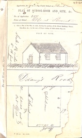
Map, Mt Pleasant School Plan, 1860
Plan of proposed school and site (Mount Pleasant School)education, mount pleasant school, no. 1022, delaney's road, vermont, non-vested schools -
 Whitehorse Historical Society Inc.
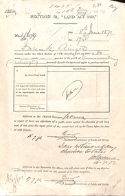
Document - Report, Section 31 Land Act 1869, 01/06/1872
Land application by Frank Ainger, referred to District Surveyor. Report by Mounted Constable Douglas with description of proposed use of land. Map of area. The area is on the corner of Whitehorse Road and Doncaster East Road.ainger, frank, douglas (mounted constable), assistant commissioner of lands and survey, whitehorse road, mitcham, doncaster east road, land settlement -
Whitehorse Historical Society Inc.
Pamphlet - Document, Maggs Family Reunion, 6/11/1994
Pamphlet on the Maggs Family reunion 6 Nov 1994 including background of Maggs Family, list of descendants, copy of marriage certificate and map of property.maggs family -
Whitehorse Historical Society Inc.
Map, Sketch plan of Box Hill Cemetery, c1980
Sketch plan of Box Hill Cemeterybox hill cemetery -
Whitehorse Historical Society Inc.
Map, City of Nunawading Historical Geography Project
Periods covered 1834-1879. Early colonists to coming of railway, 1880-1918 Land boom, bust to WW1, 1919-1944 Part WW1 to end of WW2, 1945-present Post war suburban explosion - farming, clay industries,settlement.local history, heritage awareness study steering commitee, johnston chris, walker, vanessa, vosper, maria, kellaway, carlotta -
Whitehorse Historical Society Inc.
Map, Sample Plan
Sample Plan of Shireroad construction and maintenance -
 Whitehorse Historical Society Inc.
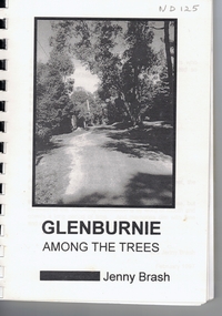
Book, Glenburnie among the trees, 1997
History of Glenburnie Road, VermontHistory of Glenburnie Road, Vermont prepared by Jenny Brash, 1997. Includes a brief history of Vermont with maps of the area. Mentioned are gold mining, orchards, farming and the tile factories. Visits by gypsies. The flora of the area. The establishment of Bloom Reserve and Hales Park, the Kirkpatrick Homes and the Vermont Elderley People's Homes. People mentioned include Paton 1940-53, Hamilton ca 1935, Brereton ca 1937-70, Tovey ca 1930-60, Rawson 1943-, Palmer 1937-, Ken Hauser 1956-, Kirkpatrick 1924-68, Hale 1946-, Esme White, Tom and Pat Fagetter, Francis Hall 1924-, Leonard Uren 1922- (Farley Green Estate). 33 pages, photographs, maps.History of Glenburnie Road, Vermont glenburnie road, vermont, brash, jenny, bloom reserve, hales park, native plants -
Whitehorse Historical Society Inc.
Pamphlet, Multi Unit Residential Development Controls, 1/03/1986
Review of Multi Unit Residential Development controls: your chance to comment including present and proposed density zone maps.land use, city of nunawading