Showing 13588 items
matching wye-river-bridge
-
 Eltham District Historical Society Inc
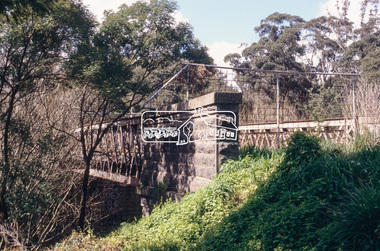
Slide - Photograph, Old Lower Plenty Bridge, c.Sep. 1989
Part of a slide show presentation "Bridges & Waterways of the Shire" by Russell Yeoman to the 13 September 1989 Society meeting. The presentation included slides of historic photos from the Shire of Eltham Pioneers collections as well as several recent views.35mm colour positive transparency (1 of 15) Mount - Agfa CS System grey 8 dotslower plenty bridge -
 Eltham District Historical Society Inc
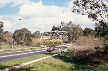
Slide - Photograph, New Lower Plenty Bridge, c.Sep. 1989
Part of a slide show presentation "Bridges & Waterways of the Shire" by Russell Yeoman to the 13 September 1989 Society meeting. The presentation included slides of historic photos from the Shire of Eltham Pioneers collections as well as several recent views.35mm colour positive transparency (1 of 15) Mount - Agfa CS System grey 8 dotslower plenty bridge -
 Eltham District Historical Society Inc
Slide - Photograph, Brougham Street Bridge, Eltham, c.Sep. 1989
Part of a slide show presentation "Bridges & Waterways of the Shire" by Russell Yeoman to the 13 September 1989 Society meeting. The presentation included slides of historic photos from the Shire of Eltham Pioneers collections as well as several recent views.35mm colour positive transparency (1 of 15) Mount - Agfa CS System grey 8 dotsbrougham street bridge, eltham -
 Eltham District Historical Society Inc
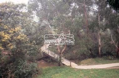
Slide - Photograph, Footbridge, Bridge Street, Eltham, c.Sep. 1989
Part of a slide show presentation "Bridges & Waterways of the Shire" by Russell Yeoman to the 13 September 1989 Society meeting. The presentation included slides of historic photos from the Shire of Eltham Pioneers collections as well as several recent views.35mm colour positive transparency (1 of 15) Mount - Agfa CS System grey 8 dotseltham, footbridge, bridge street -
 Eltham District Historical Society Inc
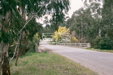
Slide - Photograph, Oxley Bridge, Henley Road, Kangaroo Ground, c.Sep. 1989
Part of a slide show presentation "Bridges & Waterways of the Shire" by Russell Yeoman to the 13 September 1989 Society meeting. The presentation included slides of historic photos from the Shire of Eltham Pioneers collections as well as several recent views.35mm colour positive transparency (1 of 15) Mount - Agfa CS System grey 8 dotsoxley bridge, henley road, kangaroo ground -
 Eltham District Historical Society Inc
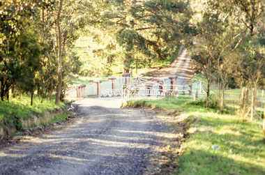
Slide - Photograph, Aqueduct Bridge, Nicholas Lane, Kangaroo Ground, c.Sep. 1989
Part of a slide show presentation "Bridges & Waterways of the Shire" by Russell Yeoman to the 13 September 1989 Society meeting. The presentation included slides of historic photos from the Shire of Eltham Pioneers collections as well as several recent views.35mm colour positive transparency (1 of 15) Mount - Agfa CS System grey 8 dotskangaroo ground, aqueduct bridge, nicholas lane -
 Eltham District Historical Society Inc
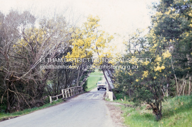
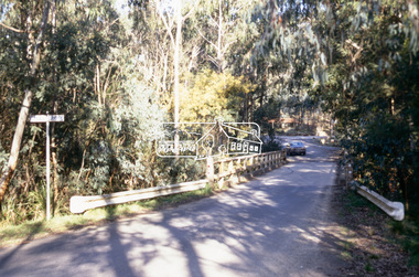
Slide - Photograph, Lintons Bridge, Nutfield, c.Sep. 1989
Part of a slide show presentation "Bridges & Waterways of the Shire" by Russell Yeoman to the 13 September 1989 Society meeting. The presentation included slides of historic photos from the Shire of Eltham Pioneers collections as well as several recent views.35mm colour positive transparency (1 of 15) Mount - Agfa CS System grey 8 dotslintons bridge, nutfield -
 Greensborough Historical Society
Photograph - Digital Image, Bridge Inn Hotel Mernda 2018, 25/07/2019
In 2018 GHS members visited Turner's Bakery in Mernda for lunch and continued on to visit historic sites remaining in the Mernda area. This photograph shows the Bridge Inn Hotel Mernda, established 1891. The hotel is still operating in the 21st century.Mernda is an area of rapid modern growth with a few remaining historic buildings dating from the 19th century.Digital copy of colour photographmernda, bridge inn hotel mernda, mernda historic sites, hotels mernda -
 Wodonga & District Historical Society Inc
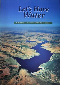
Book - Let's Have Water - A history of the Fish River Water Supply, Robin McLachlan, Denis Barrett, Jack Domis, Nick Welling, 1997
A history of the development of the management of the Fish River Water Supply Scheme in Central NSW. The scheme extends across the local government areas of the Shire of Oberon, the City of Lithgow and the City of the Blue Mountains.non-fictionA history of the development of the management of the Fish River Water Supply Scheme in Central NSW. The scheme extends across the local government areas of the Shire of Oberon, the City of Lithgow and the City of the Blue Mountains.water nsw, fish river region nsw, oberon dam, water resources development nsw australia -
 Ringwood and District Historical Society
Envelope, Packet: Ringwood Area Hotels - Coach and Horses, Empress India, Burnt Bridge. Also Antimony Mine Hotel Proclaimed 1878
Hotels list; Coach and Horses Hotel; Club Hotel Sept-1887 Wiggin sold to Lindsey; Empress India Hotel; Antimony Mine Hotel, East Ringwood, Cnr Main & Pratt St proclaimed 21-Jan-1878 owing to increase in mining population, 4 licences in locality; Burnt Bridge Hotel; "Duke of York" -
 Melbourne Tram Museum
Document - Research Notes, H. S. McComb, Details of Richmond line - Spencer St, Flinders St and Bridge Road, c1930
Notes, 9 pages, has been pinned together, giving details, opening dates, terminals, depot entries, sheave pits, curves, for the Richmond line - Spencer St, Flinders St and Bridge Road. Items 2064 to 2075 within box 72.3 in a brown folder marked "MT&O Co." red pencil on the front cover.trams, tramways, mto co, cable trams, drawings, reports, surveys, richmond, spencer st, flinders st, bridge rd -
 Melbourne Tram Museum
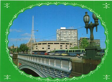
Postcard, Biscay Greetings, Princes Bridge from Batman Ave, mid to late 1980's
Colour postcard divided back - Biscay Greetings, series of featuring Princes Bridge from Batman Ave with the Arts Centre in the background. Image contained within a decorative oval. Back has space for name and address, stamp and a message and details of the postcard. Produced by Biscay Greetings, possibly mid to late 1980's. Card No. BG216trams, tramways, princes bridge -
 Eltham District Historical Society Inc
Photograph, Main Road Bridge, Eltham, c.1924
The wooden Main Road Bridge was substantially damaged in the 1924 flood and was replaced with a concrete structure Pages from a scrapbook belonging to Heather Jenkins (nee Sargeant) who lived as a child in the Police Residence at 728 Main Road, Eltham in the 1920s.This photo shows the flood damage to the bridge structure or the dismantling of the bridge post 1924 flood. Heather Sargeant was the daughter of Constable W.C. Sargeant, the local police officer in residence at Eltham, 1922-1927Glued on a brown paper scrapbook page (torn from scrapbook) with 9 black and white/sepia photos of varying sizes, 1 newspaper clipping and handwritten captions in ink.On verso in pencil "Const. W.C. Sargeant 1922-1927 - see Police list"heather jenkins (nee sargeant), eltham, police residence, constable w.c. sargeant, main road, main road bridge -
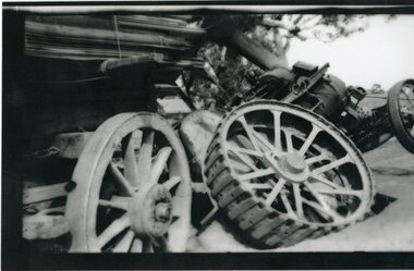 Stawell Historical Society Inc
Photograph, Frampton’s Bridge in Joel Joel where the heavy tractor that Mr Slorach was driving broke through the wooden planks
Frampton’s Bridge Joel Joel. Accident occurred while Mr Arch Slorach was crossing. The heavy tractor broke through the wooden planks. Mr Slorach who as a result of War injuries had a wooden leg was able to jump clear.shire, frampton's bridge -
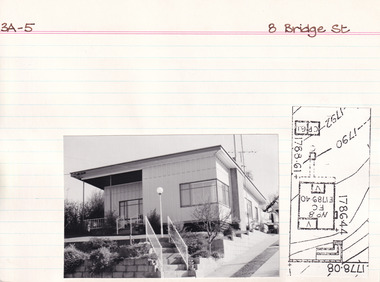 The Beechworth Burke Museum Research Collection
Card (Series) - Index Card, George Tibbits, 8 Bridge Road, Beechworth, 1976
George Tibbits, University of Melbourne. Faculty of Architecture, Building and Town & Regional PlanningIndex system that support the research for Beechworth : historical reconstruction / [by] George Tibbits ... [et al]Arranged by street names of BeechworthEach index card includes: street name and number of property, image of property, allotment and section number, property owners and dates of ownership, description of the property according to rate records, property floor plan with dimensions.beechworth, george tibbitsbeechworth, george tibbits -
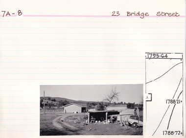 The Beechworth Burke Museum Research Collection
Card (Series) - Index Card, George Tibbits, 23 Bridge Street, Beechworth, 1976
George Tibbits, University of Melbourne. Faculty of Architecture, Building and Town & Regional PlanningIndex system that support the research for Beechworth : historical reconstruction / [by] George Tibbits ... [et al]Arranged by street names of BeechworthEach index card includes: street name and number of property, image of property, allotment and section number, property owners and dates of ownership, description of the property according to rate records, property floor plan with dimensions.beechworth, george tibbitsbeechworth, george tibbits -
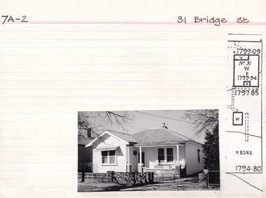 The Beechworth Burke Museum Research Collection
Card (Series) - Index Card, George Tibbits, 31 Bridge Street, Beechworth, 1976
George Tibbits, University of Melbourne. Faculty of Architecture, Building and Town & Regional PlanningIndex system that support the research for Beechworth : historical reconstruction / [by] George Tibbits ... [et al]Arranged by street names of BeechworthEach index card includes: street name and number of property, image of property, allotment and section number, property owners and dates of ownership, description of the property according to rate records, property floor plan with dimensions.beechworth, george tibbitsbeechworth, george tibbits -
 The Beechworth Burke Museum Research Collection
Card (Series) - Index Card, George Tibbits, 37 Bridge Street, Beechworth, 1976
George Tibbits, University of Melbourne. Faculty of Architecture, Building and Town & Regional PlanningIndex system that support the research for Beechworth : historical reconstruction / [by] George Tibbits ... [et al]Arranged by street names of BeechworthEach index card includes: street name and number of property, image of property, allotment and section number, property owners and dates of ownership, description of the property according to rate records, property floor plan with dimensions.beechworth, george tibbitsbeechworth, george tibbits -
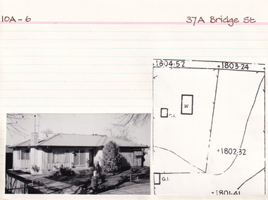 The Beechworth Burke Museum Research Collection
Card (Series) - Index Card, George Tibbits, 37A Bridge Street, Beechworth, 1976
George Tibbits, University of Melbourne. Faculty of Architecture, Building and Town & Regional PlanningIndex system that support the research for Beechworth : historical reconstruction / [by] George Tibbits ... [et al]Arranged by street names of BeechworthEach index card includes: street name and number of property, image of property, allotment and section number, property owners and dates of ownership, description of the property according to rate records, property floor plan with dimensions.beechworth, george tibbitsbeechworth, george tibbits -
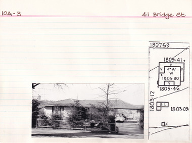 The Beechworth Burke Museum Research Collection
Card (Series) - Index Card, George Tibbits, 41 Bridge Street, Beechworth, 1976
George Tibbits, University of Melbourne. Faculty of Architecture, Building and Town & Regional PlanningIndex system that support the research for Beechworth : historical reconstruction / [by] George Tibbits ... [et al]Arranged by street names of BeechworthEach index card includes: street name and number of property, image of property, allotment and section number, property owners and dates of ownership, description of the property according to rate records, property floor plan with dimensions.beechworth, george tibbitsbeechworth, george tibbits -
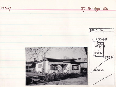
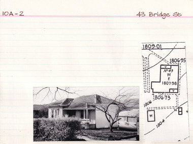 The Beechworth Burke Museum Research Collection
Card - Index Card, George Tibbits, 43 Bridge Street, Beechworth, 1976
Property - 43 Bridge Street, Beechworth - Section 10A, Town Allotment 2 - 100' x 440' Ownership details and history - 6 Jan 1871 - J. Reeve Architectural Index Card - Brian Pump and Tony Dugan - Photographers beechworth, george tibbits -
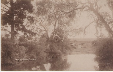 Sunbury Family History and Heritage Society Inc.
Photograph
The Jacksons Creek and the Macedon Street stone arched bridge are the features in this postcard with a view of a vineyard on the LH river bank. The wine industry was one of the early industries caroused out in Sunbury by the early European settlers in the district.A sepia photograph in post card format of a waterway with overhanging trees and an arched bridge in the middl;e distance.JACKSONS CREEK, SUNBURYjacksons creek, macedon street bridge, vineyards. -
Clunes Museum
Artwork, other - WATER COLOUR
WATER COLOUR OF RIVERGUM TREE PAINTED BY N.H.E.McDONALDLARGE RIVER GUMS IN FOREGROUND. FIVE SHEEP IN SHADE IN RURAL SETTING.RIVER GUMS MURRABIT WEST, VICTORIA. N.H.E. McDONALD local history, illustration, watercolour, mcdonald -
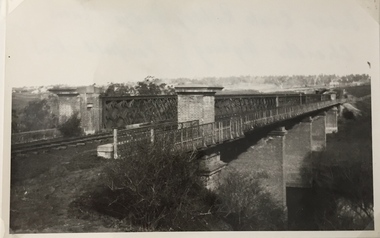 Kew Historical Society Inc
Photograph, Railway Viaduct, c.1919
The railway viaduct linking Kew and Fairfield was created for the Outer Circle railway.Railway viaduct, Yarra River, linking Kew and Fairfield. Built by John Monash for the Outer Circle Railway. In 1930 converted into the Chandler Highway Bridge for vehicular traffic. The point-of-view of the photograph shows Kew in the distance. Annotations on reverse: "Outer Circle Railway Bridge (now Chandler Highway) Fairfield-Kew, about 1919. Property of Miss Foley.outer circle railway, railway viaduct (kew), john monash -
Australian Commando Association - Victoria
Mixed media - From Tidal River to Timbered Knoll, Education Package - From Tidal River to Timbered Knoll
This training package was produced by AVA Vic for use within the Victorian educational curriculum for years 10 to 12. It is particularly focused on those students who are attending Wilsons Promontory National Park and undertaking educational activities through the Parks Victoria Education Centre. The eight module program and teachers notes provides a historical workbook for students to gain a better understanding of the role of Tidal River as the initial training location for Australian and New Zealand commandos during World War II and the later military operations that were undertaken by commandos during World War II.Using original World War II footage, supplemented by later official record data this video and training package provides unique material regarding the history of Australian special operations during World War II.ww2, world war ii, independent companies, commando companies, australian special forces, tidal river -
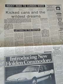 Peterborough History Group
Newspaper - Newspaper article ab out the road the The Lodge fishing spot, Rocky road to Curdies River
The fishing spot known as The Lodge was accessed, for many years, via private property. This article is about an on site meeting, who attended and what was said in regards to the upgrading of a road for access to the river. Includes a letter to the Editor from Ronald Irvine stating their position. Enquiries made on March 11th 2021 with Ronald Irvine revealed that the road had deteriorated and vehicles were becoming bogged, requiring the farmer to pull them out with a tractor. Council were reluctant to fund repairs and the result was that the gate was locked and public access no longer available.Significant because it is a record of community and government discussion about community access to a popular fishing location on the Curdies River.Two page newspaper article from the Cobden Times March 5 1986peterborough, curdies river, the lodge, ronald irvine, the lodge fishing, timboon anglers club, john irvine, the cobden times, 5 march 1986 -
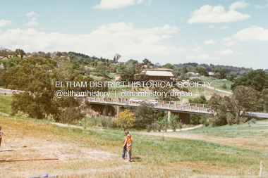 Eltham District Historical Society Inc
Photograph - Colour Print, Lewis Tulk, Bridge Street, Eltham District Scout Camp, Eltham Town Park, c.1982
View looking southeast from Eltham Town Park (present-day Al;istair Knox Park) across Bridge Street towards the new Eltham Community Centre. Donated by Lewis Tulk, former Scout Area Training Commisioner for Leaders.scouts victoria, scout leader training, lewis tulk collection, yarra batman area, alistair knox park, bridge street, eltham community centre, eltham district scout camp, eltham town park -
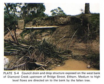 Eltham District Historical Society Inc
Work on paper (Sub-Item) - Photograph, Council drain and drop structure exposed on the west bank of Diamond Creek upstream of Bridge Street, Eltham
Colour photograph of a muddy creek (probably after a downpour) showing council drain and drop structure exposed on the west bank of Diamond Creek upstream of Bridge Street, Eltham. Mediun to high level water flows are directed on to the bank by the fallen tree.eltham, creek, diamond creek, bridge street, drainage, waterflow, vegetation -
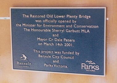 Greensborough Historical Society
Photograph - Digital Image, Anne Paul, Plaque: Opening of restored Old Lower Plenty Bridge 2001, 14/03/2001
This plaque commemorates the opening of the restored Old Lower Plenty Bridge, opened on 14/03/2001 by the Minister for Environment and Conservation Sherryl Garbutt MLA and Mayor of Banyule Cr Dale Peters. The project was jointly funded by Banyule Council and Parks Victoria.Digital copy of colour photograph of memorial plaquelower plenty, lower plenty bridge, sherryl garbutt, dale peters, banyule council, parks victoria -
Glenelg Shire Council Cultural Collection
Photograph - Photograph - Casterton, Victoria, c. 1963
SOURCED FROM CASTERTON TOWN HALL (FORMER SHIRE OF GLENELG)Black and white photo of Glenelg River Bridge at Casterton.tourism, casterton