Showing 4640 items matching "avenue"
-
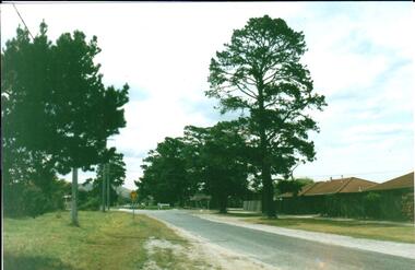
 Phillip Island and District Historical Society Inc.
Photograph, circa 1940
Commercially available print made approx 1940s. Bayview Guesthouse burn down in 1950s.L shaped Jetty, left, Jetty Shed at end. Large trees along beach front. Thompson Avenue middle showing most buildings on right. Bayview Guesthouse in foreground right.Valentine Series (rest cut short)local history, photography, photographs, slides, film, aerial view of cowes, black & white photograph, foreshore, jetty -
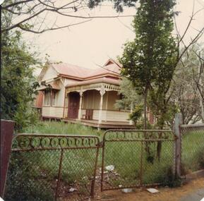 Phillip Island and District Historical Society Inc.
Photograph, 1978/79
This was Arnie Brown's house in the main street of Cowes. Arnie lived at Hastings, but came to live on Phillip Island in 1908. One of the best known boatman - he provided fishing trips for visitors. He died in the autumn of 1952 from an accident when tying up at Cowes Jetty. He had numerous fishing boats.Old house in Thompson Avenue, Cowes. Red iron roof, red tank on stand on left hand side of picture. Verandah around front of house. Note double wire gates.local history, photographs, historic, buildings - historical, coloured photograph, john cook, phillip island, arnie brown -
Ringwood and District Historical Society
Biography, Ringwood and District Historical Society, Interview notes - short biography on Miss Daisy Paddock, teacher at Ringwood State School, circa 1970s, c.1970s
Single page of notes/interview record of Miss Daisy Paddock, teacher at the Ringwood State School in Greenwood Avenue (now Federation Estate) - Interview write-up by Ringwood History Group.Transcript: "Miss Janet Daisy Paddock She was an extremely well-liked and well-regarded teacher at the old RW State School in Greenwood Ave (Now Federation Estate). She taught between the years of 1927 until 1941, then again after the war from 1951 until final retirement in 1961. In fact she was so liked that her former pupils formed "The 2997 Club" , which met in her honour every year for a meal (and, of course, their guest of honour). 2997 was the RW SS number. In some of her letters about early life in RW, she recalls the RW Mail being produced and printed in a small wooden building in Adelaide St. [Adelaide St is officially no longer on the RW map but it went from the highway nearly to Mullum Creek, between Melbourne St and Warrandyte Road.^ In fact there is an unmarked 100 metres of road that is on the west side of Officeworks that ends in a roundabout at the bottom of Eastland carpark. I don't believe it is exactly in the same position as the old Adelaide Street but it pretty close. That would put the old Mail office in the vicinity of the Maroondah Council service centre in Eastland.] She also recalls that there were nearly a dam on every corner. In fact, I recall in my 1950s/60s childhood that there were still many dams around. As I previously mentioned, with the RW-Mitcham claybelt, there wasn't much top soil and the orange clay is very fine, so when the banks of the dam get wet, it wass very slippery. I often remember playing around in those dams, as most boys did in those days. A friend and I spied an old bath used to water some horses so after some trial and errors we made it waterproof and fashioned a couple of paddles out of wooden fence pailings. The first launch in the local dam was fine and we managed to manouver through the bullrushes into the middle. The only thing that I forgot about was that I had a d<^ that went everywhere with me and, rather than bark from the bank, he swam over to us and tried to get aboard. Bath tubs are not known for their seaworthness and he tipped us all in the drink. Of course the bath sank like a rock. We scrambled on the bank and he added insult to injury when, as all dogs do, gave the usual shake and sprayed us with water. My mind often comes back to one dam right next to the Croydon pub - that provided water to the Magg's orchard - dug in the usual fashion on about 3 metres deep scraped in the local clay, it was at this dam in the early sixties that a young boy drowned. After that we were pretty careful around dams. Going back to Daisy's memories, she recalls that the kids often started late on Monday mornings as Monday was Market Day at RW. They used to watch the stock being herded into the yards and people getting off the steam trains. Her family home was at Gruyere and her father used to drive to RW market and stop midway at the Burnt Bridge hotel and rest the horses. [I suspect that he may have watered other things besides the horses.] They eventually moved to RW in Thanet St. Miss Paddock still remembers the old RW school at the corner of RW St and Whitehorse Road, it was very small so they built the new school in Greenwood Ave. RW had a population of around 2,(K)0 when Daisy became an Assistant Class Five. She used to walk through the open paddocks, surrounded by bush and orchards. She goes on to say that the bush was alive with wildlife and a natural playground for the children. Miss Paddock was a member of the Soroptomist Club in RW (equivalent to Rotary), active in the church and local community. At our archives, we have a plaque that grac^ the entrance to the school, naming it the Miss Daisy Paddock library, in honour of a great woman in our city." -
Port Melbourne Historical & Preservation Society
Photograph - CD-ROM, Dunstan Estate, Department of Public Works, 1936
Twenty five (25) black and white or sepia photographs of the houses of the Dunstan Estate during their building i.e. Griffin Crescent and Southwood Avenue .26 - cd containing several versions of photographs built environment - domestic, domestic life, department of public works, dunstan estate, percy e everett, henry pye, albert dunstan -
Whitehorse Historical Society Inc.
Article, Railway Work Piles Up, 2016
Over 1000 piles of up to 1 metre in diameter will be bored along the length of the 9m deep cutting, every 2.7 metres between Blackburn Railway Station and Metropolitan Avenue, Nunawading.Over 1000 piles of up to 1 metre in diameter will be bored along the length of the 9m deep cutting, every 2.7 metres between Blackburn Railway Station and Metropolitan Avenue, Nunawading.Over 1000 piles of up to 1 metre in diameter will be bored along the length of the 9m deep cutting, every 2.7 metres between Blackburn Railway Station and Metropolitan Avenue, Nunawading.blackburn railway crossing, blackburn railway station, metropolitan avenue, nunawading -
!['Studley House', Nolan Avenue [Kew]](/media/collectors/550653872162f11fb04854aa/items/658d1a9d0f23e8f1e738f8fa/item-media/658d1ac70f23e8f1e738f9c2/item-fit-380x285.jpg) Kew Historical Society Inc
Kew Historical Society IncPhotograph - 'Studley House', Nolan Avenue [Kew], c. 1965
The first section of Studley House, now part of the preparatory school for Xavier College conducted by the Society of Jesus in Kew, was built in about 1857 for Parliamentarian John Hodgson, an early settler in the district, as a two-storey residence in the Classical Revival style. The name Studley House was first recorded in the Kew ratebooks in 1862, after the house was purchased in 1860 by James McEvoy, squatter. Alterations and an extension, designed by William J Ellis were undertaken in 1875. The house was again altered in 1919 during the ownership of John Wren, former bookmaker, ALP lobbyist, influential Irish-Catholic and millionaire. After 1969 the house was used by the school. (Victorian Heritage Database, 2023)This work forms part of the collection assembled by the historian Dorothy Rogers (1905-1973), donated to the Kew Historical Society by her son in 2015. The manuscripts, photographs, maps, and documents were sourced by her from both family and local collections or produced as references for her print publications. Many were directly used by Rogers in writing ‘Lovely Old Homes of Kew’ (1961) and 'A History of Kew' (1973), or the numerous articles on local history that she produced for suburban newspapers. Most of the photographs in the collection include detailed annotations in her hand. The Rogers Collection provides a comprehensive insight into the working habits of a historian from the 1960s to the 1970s. Original monochrome photograph of the view from the first floor verandah of Studley House in Nolan Avenue, Kew. The photo shows the detail of the cast iron lace work used on this section of the verandah.Annotation verso: "Lovely lacework of the balcony Studley House"dorothy rogers, studley house -- nolan avenue (kew) -
![Studley House, Nolan Avenue [Kew]](/media/collectors/550653872162f11fb04854aa/items/658f96939239cf6fd4376d56/item-media/658f96e99239cf6fd4376ed9/item-fit-380x285.jpg) Kew Historical Society Inc
Kew Historical Society IncPhotograph - Studley House, Nolan Avenue [Kew]
The first section of Studley House, now part of the preparatory school for Xavier College conducted by the Society of Jesus in Kew, was built in about 1857 for Parliamentarian John Hodgson, an early settler in the district, as a two-storey residence in the Classical Revival style. The name Studley House was first recorded in the Kew ratebooks in 1862, after the house was purchased in 1860 by James McEvoy, squatter. Alterations and an extension, designed by William J Ellis were undertaken in 1875. The house was again altered in 1919 during the ownership of John Wren, former bookmaker, ALP lobbyist, influential Irish-Catholic and millionaire. After 1969 the house was used by the school. (Victorian Heritage Database, 2023)This work forms part of the collection assembled by the historian Dorothy Rogers (1905-1973), donated to the Kew Historical Society by her son in 2015. The manuscripts, photographs, maps, and documents were sourced by her from both family and local collections or produced as references for her print publications. Many were directly used by Rogers in writing ‘Lovely Old Homes of Kew’ (1961) and 'A History of Kew' (1973), or the numerous articles on local history that she produced for suburban newspapers. Most of the photographs in the collection include detailed annotations in her hand. The Rogers Collection provides a comprehensive insight into the working habits of a historian from the 1960s to the 1970s. Original monochrome photograph of architectural elements used in the decorative scheme on the exterior of Studley House in Nolan Avenue, Kew. The POV is of the rendered and painted Doric columns supporting the first floor colonnade.dorothy rogers, studley house -- nolan avenue (kew), xavier preparatory school -
![Studley House, Nolan Avenue [Kew]](/media/collectors/550653872162f11fb04854aa/items/658f977b9239cf6fd4377127/item-media/658f978a9239cf6fd4377163/item-fit-380x285.jpg) Kew Historical Society Inc
Kew Historical Society IncPhotograph - Studley House, Nolan Avenue [Kew]
The first section of Studley House, now part of the preparatory school for Xavier College conducted by the Society of Jesus in Kew, was built in about 1857 for Parliamentarian John Hodgson, an early settler in the district, as a two-storey residence in the Classical Revival style. The name Studley House was first recorded in the Kew ratebooks in 1862, after the house was purchased in 1860 by James McEvoy, squatter. Alterations and an extension, designed by William J Ellis were undertaken in 1875. The house was again altered in 1919 during the ownership of John Wren, former bookmaker, ALP lobbyist, influential Irish-Catholic and millionaire. After 1969 the house was used by the school. (Victorian Heritage Database, 2023)This work forms part of the collection assembled by the historian Dorothy Rogers (1905-1973), donated to the Kew Historical Society by her son in 2015. The manuscripts, photographs, maps, and documents were sourced by her from both family and local collections or produced as references for her print publications. Many were directly used by Rogers in writing ‘Lovely Old Homes of Kew’ (1961) and 'A History of Kew' (1973), or the numerous articles on local history that she produced for suburban newspapers. Most of the photographs in the collection include detailed annotations in her hand. The Rogers Collection provides a comprehensive insight into the working habits of a historian from the 1960s to the 1970s. Original monochrome photograph of architectural elements used in the decorative scheme on the exterior of Studley House in Nolan Avenue, Kew. The POV is of the rendered and painted Ionic columns forming the first floor colonnade.dorothy rogers, studley house -- nolan avenue (kew), xavier preparatory school -
 Lakes Entrance Historical Society
Photograph - Historic House, 1999
This house was once the residence of Jules Lake, inaugural member of the Lakes Entrance RSL. A boat builder, he lost a leg on WW1 service.Colour photograph of timber house in Barkes Avenue. Corrugated iron roof, gablet ventilator on ridge. Window has metal window shade. White picket fence. Lakes Entrance Victoriahouses, heritage study -
 Bendigo Historical Society Inc.
Postcard - Alice McGregor Postcard Collection, 1900 - 1920
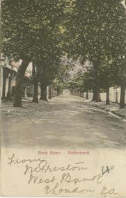
Alice McGREGOR Born: 1908; unknown parents. Possibly adopted by the Salter family? Electoral Roll 1936: Highland Terrace Kangaroo Flat. Alice Mary Salter and William Robert Salter living together; presumed to be sister and brother. William Robert Salter was killed in a MVA in Bendigo in 1937 aged 26. In Victoria in 1938, Alice Mary Salter married James Thomas McGregor (born Victoria 1917, died Victoria 1983, buried Fawkner Cemetery) Lived: 1968; 22 Wade Street Golden Square Alice McGregor Died: 1999 aged 91 at Anne Caudle Centre, Bendigo Buried: Kangaroo Flat Cemetery See additional research. Postcard Album of Alice McGregor contained 86 post cards.Postcard Album of Alice McGregor containing 86 post cards. See 1400 Colour photo of Herte Street, Stellenbosch, South Africa. Tree lined avenue with houses either side. Addressed to Miss A. Stapleton, Arcade, Bendigo, Victoria, Australia Sender - M. Preston, West Bank, East London, S.A. Stamp date Sept. 28, 1905 postcard, collector, alice mcgregor -
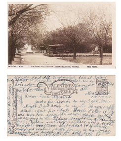 Williamstown Botanic Gardens- Hobsons Bay City Council
Postcard - Williamstown Botanic Gardens, circa 1900-1924
The original postcards in this series (2013.002 to 2013.018) were generously loaned to Williamstown Botanic Gardens by a private collector for copying. The postcards are evidence of the interest the gardens held as a subject for postcard publishers. The text and images provide a snapshot into fashions, social interests and concerns of the time. The professionally produced images provide a pictorial history of Gardens including changing planting styles, various structures and features of the Gardens eg the aviary, cannons, the fountain, the second Curator’s Lodge and gates. The images offer an opportunity to compare garden vistas with the present day. This postcard is evidence of the placement of two of the cannons relocated from Fort Gellibrand in 1906 and that they were in place in the Gardens in 1924. They were removed from the Gardens in the 1960s. These same cannons remain a feature on the Williamstown waterfront in 2013. The image also shows the original Elm Avenue plantings. A sepia scene looking west towards statue of Alfred Thomas Clark, with cannons on either side of statue pointing east down what is known as the Palm Avenue. The statue is surrounded by a white fence consisting of posts and a top rail. The top of the statue is hidden by the branches of the elm trees. It appears that the elms are in the process of either losing their leaves or new leaf growth. A cactus plant can be seen beneath the lower branches of the elm tree of the right closest to the camera. The cannons were moved from Fort Gellibrand to the Gardens in 1906.Front: VALENTINE’S, M.356 ELM AVENUE WILLIAMSTOWN GARDENS MELBOURNE, VICTORIA. REAL PHOTO. Reverse: vertical on left side of card and underlined: ‘Published by the Valentine & Sons Publishing Co. Ltd. / Melbourne, Sydney & Brisbane’. Top centre of card: Contains logo of ‘VALENTINES / REAL PHOTO SERIES / POSTCARD’. Top right hand corner is stamped ‘BRANCHES (enclosed in a scroll) / SYDNEY / LONDON / DUNDEE / DUBLIN / CAPETOWN / MONTREAL / TORONTO’ The card is dated ‘29/12/24’ and addressed to ‘Dear Leah Alf & Dad’ signed by ‘Margaret’. postcard, gardens, post-card, williamstown-botanic-gardens, hobsons-bay-city-council, statue, clarke, alfred-thomas-clarke, cannon, elm, cactus, 1924, fort-gellibrand, 1906, armstrong, clark -
 Kew Historical Society Inc
Plan - Subdivision Plan, J R Mathers & McMillan, Plan of Subdivision of Part of Crown Portion 83 at Kew : LP6669, 1923-1939
In 1888, in the section of Park Hill Road between Belmont Avenue and Normanby Road there was only one street running between Park Hill Road and Cotham Road. This was Park Road, later to be named Adeney Avenue. Subsequent 20th century subdivisions created the ‘through roads’ of Cecil Street, Wimba Avenue, Florence Avenue, Marshall Avenue, Uvadale Road, and Barrington Avenue. This subdivision represents an attempt by auctioneers, rather than town planners to create an urban environment from larger residential allotments or in many cases farmland. Existing streets such as Parkhill and Normanby Roads provided a convenient starting point for the surveyors, but the Road named ‘Street Street’ indicates the role of the private surveyor in creating streets. Given that a number of allotments are listed as sold on the plan, the street is presumably Cecil Street. Even those lots that had been sold do not quite match the dimensions of the blocks in this parcel of land today, indicating that either further subdivisions or boundary alterations occurred.Subdivision plans are historically important documents used as evidence for the growth of suburbs in Australia. They frequently provide information about when the land was sold as well as evidence relating to surveyors and real estate and financial agents. The numerous subdivision plans in the Kew Historical Society's collection represent working documents, ranging from the initial sketches made in planning a subdivision to printed plans on which auctioneers or agents listed the prices for which individual lots were sold. In a number of cases, the reverse of a subdivision plan in the collection includes a photograph of a house that was also for sale by the agent. These photographs provide significant heritage information relating house design and decoration, fencing and household gardens.The photograph may also be aesthetically significant depending on the importance of the photographic atelier.Hand-drawn subdivision plan of 19 lots facing Parkhill Road, Normanby Road, and an unnamed street [now Cecil Street] in Kew.Estate Agent notes in ink indicate those lots which had sold.subdivision plans - kew, parkhill road - kew, cecil street - kew, normanby road - kew, cecil street -kew, parkhill road - kew, normanby road - kew, crown portion 83 - kew -
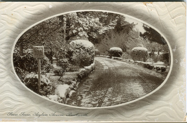 The Beechworth Burke Museum
Postcard, R & B Hall, c.1930
This postcard was published by R. & B. Hall in Beechworth and printed in Saxony, circa 1930. Saxony is a landlocked state of Germany which borders the states of Brandenburg, Saxony-Anhalt, Thuringia, Bavaria and the countries of Poland and the Czech Republic. This particular postcard is embossed with a pattern which surrounds the middle image in the center of the card. This image depicts Asylum Avenue which leads to the Mayday Hills Asylum in Beechworth, Victoria. What makes this scene particularly interesting is the appearance of snow which is rare in Beechworth. The road depicted on the postcard has track marks made by a car with thin wheels. Beechworth's Mayday Hills was chosen as the site of Victoria's newest asylum, at the time, due to the landscape and altitude. The hilltop atmosphere and the native fauna, it was argued, would assist in the cure of the patients kept at the hospital (Wood 1985, 122). The positioning of the hospital had a beneficial effect on the rural town. A pamphlet published by James Ingram and Son (1849) reveal that famous landmarks in Beechworth which included the Post Office, Gaol, Courthouse and Asylum "demonstrate the appreciation of Beechworth by the Government not only as as important district center, but also as a site unrivaled as a sanitarium". There were other locations in contention at the time, but ultimately Beechworth was chosen (Craig 2000, 33). Prior to the creation of the Asylum in Beechworth, those charged with having mental illnesses or, as it was termed, "insanity" were unable to be properly cared for in the Gaol (which is where they were often sent). John Buckley Castieau wrote, in 1861 for the Ovens and Murray Advertiser, that the Gaol was unable to properly care for those classified then as "insane" but that they would endeavor to treat them above the other inmates (which he notes is not always the case in other establishments). Castieau wrote this in favour of supporting the building of the Mayday Hills Hospital in Beechworth. It was stated that at the time the Mayday Hills Hospital was built, there were 83 prisoners kept in the Gaol who were to be rehoused to the Hospital on the grounds of "insanity". The classification as someone as "insane", in this period of time is a reflection on the inability to cure and understand illnesses of the mind during the mid to late 1800s. Beechworth's Mayday Hills was chosen as the site of Victoria's newest asylum, at the time, due to the landscape and altitude. Opening on the 24th of October 1867, the Mayday Hills Hospital was originally named the "Ovens Lunatic Asylum", a title which is very much a product of its time. Whilst controversial, changes to the name is part of the history of the Hospital and can provide much insight into the understanding of mental illness throughout history and the use/disuse of this term provides information into the reception/changing opinions of mental illness in society. The Hospital would later become known as the "Mayday Hills Asylum" and/or "Mayday Hills Hospital" with the latter being the most commonly used title. An article in the Ovens and Murray Advertiser notes that on the 7th of March 1865, the foundation stone of the Hospital was laid (it would officially open in 1867) and that it was such a moment of accomplishment and joy for Beechworth that a letter to the editor even suggested that there should be a holiday dedicated to the day the foundation stone as laid. This reveals an extent to which the townspeople of early Beechworth valued the construction of the Hospital in their town. It provided the town with a sense of prestige and honour.At first glance, the remains of the Mayday Hills Hospital in Beechworth, Victoria, inspire tragedy, trauma and beauty. The buildings themselves, with their Italianate style Renaissance architecture designed by J.J. Clark (Craig 2000, 49 & Smith 2016, 203) reflect a bygone period of European and Australian history. The gardens provide a sense of tranquility and beauty. The experience of those within these walls remains a valuable area of study to provide a more complete understanding. This particular hospital is considered the fourth of its like and one of three identified as the largest of their kind. The Mayday Hills Hospital is a sister to the Kew and Ararat Asylums in Melbourne which are both located in relative proximity. Understanding the role of the Mayday Hills Hospital in Beechworth history is integral to understanding the development of the goldfields town, but also for providing important information as to the history of caring for, and the reception of, mental illnesses in Australian and wider European history. Mayday Hills provides a case study which can be researched through oral history, an analysis of the grounds/buildings and through images like this postcard which portray the structure in a highly deliberate manner. Images like this depict the strong façade of the Hospital and provide a glimpse into the tranquility of the gardens. This has been done deliberately to provide a sense of comfort and healing about the building to those looking from the outside. Further research into the importance of the Hospital in Beechworth and it's connection to the town will be supported through images like these kept in the Mayday Hills photo album in the collection of the Burke Museum.Pale coloured rectangular postcard printed on matte embossed card.Obverse: Snow Scene; Asylum Avenue, Beechworth. / Reverse: POST CARD / ADDRESS ONLY / Published by R. & B. Hall, Beechworth. / Printed in Saxony. / 3447 [crossed out] / 1997.2492 / AFFIX STAMP /asylum, asylum avenue, beechworth, snow north-east vic, victoria, snow scene, mayday hills, mayday hills hospital, mental hospital, colonial attitudes, mental health, history, town development, postcard -
 St Kilda Historical Society
Postcard, Brighton Rd (south west)
Photo shows two adults and four children with croquet sticks in hand in front of building black and white photograph, unmounted, copy, good conditionOn back: Brighton Road, w side Built for Emil Thoneman, Merchant. Demolished approx 1960. Flats now on the site in Wimbledon Avenue -
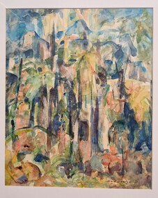 Glenelg Shire Council Cultural Collection
Painting, Enid Denton, Rain Forest, 1972
Abstract scene of a rainforest. Image of trees in greens, browns, blues and yellows. Strong brush strokes and bold shapes give the impression of dense trees. It is darker towards the bottom and lighter at the top giving the impression of light falling through treetops from the sun. Mounted on cream matt in pale green frame, with glass glazing.Front: Enid Denton (lower right) (brown paint) Back: Rain Forest $600.00 Enid Denton, Smith Avenue, Croydon 3136cema, portland artists society, female artist, female, female artists, trees, abstract -
 Ringwood and District Historical Society
Photograph, Exterior view of Ringwood North State Bank , north-east corner of Dickson's Crescent and Warrandyte Road
The new Ringwood North State Bank premises on the north-east corner of Dickson's Crescent. Exterior view. Unknown date. Opened 25 October 1971At the corner of Dickson's Crescent and Warrandyte Road, Ringwood North. Photographer Laurie Richards, 4 Tower Avenue, Alphington. Negative #71-3031 -
 Ringwood and District Historical Society
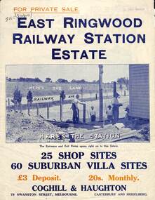
Flyer, Land Sale Brochure, East Ringwood Station Estate - c.1925
Multi-fold double sided sheet with yellow and blue print and blue monotone photographs advertising private sale of retail and residential sites. Brochure includes price list, and details of subdivision features and local facilities, with photographs. Additional clipped map of Estate on cardboard backing with handwritten sales notations and title ref LP11245.Subdivision includes Railway Avenue, Dublin Road, Lawrence Grove, Stanley Avenue. Agents - Coghill & Haughton, 79 Swanston Street, Melbourne, Phone Central 2793. Photographs include construction of East Ringwood Railway Station, "The Dive" where aquatic sports are held, Old East Ringwood Township, Davey's Hill. -
 Greensborough Historical Society
Poster - Planning Document, City of Heidelberg, Subdivision Plan # 19 - Parish of Keelbundoora, Crown Portion 16, Watsonia "Black's subdivision', 1924
Subdivision Plan # 19 - Parish of Keelbundoora, Crown Portion 16, Watsonia "Black's subdivision". This subdivision plan includes proposed street names which were later changed (e.g. Morwell Street (not Morwell Avenue) now called Greenwood Drive). Includes Lambourn Road, Black Street, Grace Street, Eden Avenue, High Street, Kenmare Street, Morwell Avenue, Greensborough Road, Mundy Street, Ladd Street.An example of hard copy subdivision plans from the Greensborough area. Mainly from the Shire of Diamond Valley era (1964-1994).Plan (single sided) mounted on heavy card. Stamped and handwritten Council permissions, dates and other details. subdivision plans, city of heidelberg, greensborough, main street greensborough, shire of heidelberg, watsonia, black family -
Phillip Island and District Historical Society Inc.
Photograph, circa 1930
The Esplanade looking towards "The Continental" from Thompson Avenue.Early model cars parked and travelling bottom left to top. Middle right made footpath with men and women pedestrians. Fences and hedges along right top to bottom Gas lights in foreground.The Esplanade, Cowes No 72local history, photography, photographs, slides, film, street scape, black & white photograph, street scapes 1930s -
 Federation University Historical Collection
Book, Ballarat Litho & Printing Co, Lucas's Staff's Appreciation of Brave Men, June 1919, 06/1919
The book relates to the Ballarat Arch of Victory and avenue of honourBeige covered book with picture of Ballarat's Arch of Victory of 102 pages. ballarat, lucas, ballarat arch of victory, ballarat avenue of honour, world war one -
Canterbury History Group
Ephemera - Unit 2/33 Wentworth Avenue Canterbury, 2000
Advertisement for auction of 2/33 Wentworth Avenue on 26.2.2000Advertisement, includes a coloured photograph of an interior roomcanterbury, wentworth avenue, karen gornalle -
 Lakes Entrance Historical Society
Photograph, Hancock family Lakes Entrance Victoria, 2016
taken at 5 Uplands Avenue Lakes Entrance Victoria.Colour photograph showing Shirley Hancock nee Eaton at home with two special possessions blue Australian pottery vase and Hilary Jackman painting Also two other colour photographs taken same day showing collectables . 2016 genealogy, hancock family -
 Hume City Civic Collection
Photograph, Early 1980's
A coloured photograph of Cornish Street, looking west taken from Horne Street, with an avenue of pine trees on either side of the road. There is a roundabout at the first intersection and Mt. Holden can be seen in the distance.cornish street, horne street, mt. holden, george evans collection -
 Whitehorse Historical Society Inc.
Document, Blackburn Presbyterian Church, 1960
Photocopy of brochure celebrating the opening of Blackburn Presbyterian Church (now The Avenue Uniting Church) 21 February 1960.Photocopy of brochure celebrating the opening of Blackburn Presbyterian Church (now The Avenue Uniting Church) 21 February 1960. Includes history of the Blackburn and Blackburn South churches and detailed description of the new building.Photocopy of brochure celebrating the opening of Blackburn Presbyterian Church (now The Avenue Uniting Church) 21 February 1960. williams, jessie, blackburn presbyterian church, the avenue uniting church, blackburn, blackburn south presbyterian church -
Ballarat RSL Sub-Branch Inc.
Folder - War Memorials Ballarat
Memorials - Boer War; Arch of Victory & Avenue of Honour; Memorial Cairn & Cross of Remembrance; Rotunda & Roll of Honour WWI; Memorial Wall; Cenotaph; South-East Asia; Australian Ex-POWliterature, ballarat rsl, ballarat -
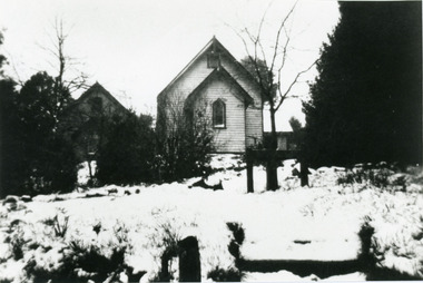 Mt Dandenong & District Historical Society Inc.
Photograph, St Matthew's Anglican Church Olinda
View from Monash Avenue of St Matthew's Anglican Church with snow covering ground. The church was built in 1903, but this photograph is post 1935 as the Church Hall can be seen behind the trees on the left.olinda, church, st matthew's church, anglican church, st matthew's anglican church, monash avenue, snow -
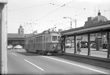 Melbourne Tram Museum
Negative, Travis Jeffrey, 11/06/1960 12:00:00 AM
Negative of tram 849 at Batman Avenue terminus. Tram has destination Prahran and Route No 70. note advert on front of tram for Magree Knitwear and the kiosk on the right hand side and a telephone box.Paper folder that contained the negative had "NR31A" written in red ink, "M10" written in pencil, "21A" written in blue ink, and date stamped as 11 Jun 1960.trams, tramways, sw5 class, batman ave, swanston st, tram 849 -
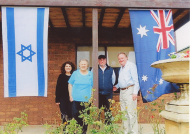 Lakes Entrance Historical Society
Photograph - Shirley and Brian Hancock, Jeffrey Lederman and Sharon Siger, Hancock family Lakes Entrance Victoria, 1/12/2016 12:00:00 AM
Lederman family were financiers of East Gippsland Timber Industry - . Shirley Hancock's Sharon Frock Salon on Esplanade Lakes Entrance was named after Sharon SigerColour photograph showing Shirley and Brian Hancock welcoming Jeffrey Lederman and Sharon Siger nee Lederman on verandah at 5 Uplands Avenue, with Australian and Jewish flags flying, Lakes Entrance Victoriabusinesses, timber industry -
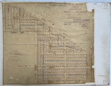
 Ringwood and District Historical Society
Map, Plan of Subdivision - State School Estate, Ringwood East, Victoria - (Undated, circa 1920s)
Map of land for sale attached to green cardboard backing with handwritten notations showing numbered allotments on Dublin Road, Holland Road, King Street, Charles Street and Purser Avenue, Ringwood East.Locality plan includes reference to proposed Ringwood East railway station which opened in 1925. -
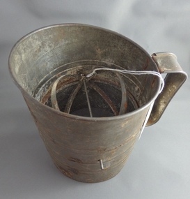 Greensborough Historical Society
Flour Sifter, Kande, Metal flour sifter, 1954c
This sifter was used at Poulter Avenue Greensborough for over 55 years.Owned and used by the Colvin family for over 55 years.Metal sifter with metal handle and green painted winder. Some rust damage and a hole in wire."Kande" brand inside outline map of Australia, stamped on side with patent information.flour sifter