Showing 2520 items
matching goldfield map
-
 Clunes Museum
Map - CLUNES MT GREENOCH TALBOT GOLDFIELDS
... MAP OF CLUNES GOLDFIELDS CIRCA 1883 .1 PAPER UNMOUNTED... history document maps mining CLUNES MT GREENOCK TALBOT GOLDFIELDS ...MAP OF CLUNES GOLDFIELDS CIRCA 1883 .1 PAPER UNMOUNTED, SEPIA, .2 BORDER MOUNTED, COLOURED .3 COPY OF MAP BLACK ANDWHITE .4 ORIGINAL MAP, COLOURED, HAS CANVAS BACKINGCLUNES MT GREENOCK TALBOT GOLDFIELDS local history, document, maps, mining -
Clunes Museum
Document - DOCUMENTS/MAP, 1874-5
COLLECTION OF LETTERS - 1 X JANUARY 5,1874 1 X MAY 23, 1874 1 X JANUARY 8, 1874 1 X SEPTEMBER 4, 1874 1 X JANUARY 10, 1874 1 X APRIL 5, 1875 1 X JANUARY 15, 1874 1 X MAY 10, 1875 1 X JANUARY 22, 1874 1 X MAY 13, 1875 (3 PAGES) 1 X JUNE 7, 1875 1 X JANUARY 28, 1874 1 X JUNE 29, 1875 1 X JANUARY 29, 1874 1 X DECEMBER 23, 1875 DONATED TO MUSEUM BY JEFF MACKCOLLECTION OF LETTERS(3) FROM MR. JESSUP (SOLICITOR) OF CLUNES WATER SUPPLY FROM 1870. PRIVATE LETTER FROM JEFF MACKAY. MAP - CLUNES RETICULATION CIRCA 1874. DETAILS OF PIPES LAID AND PROPOSED PIPE LINES, FIRE PLUGS, VALVES.CORRESPONDENCE FROM SOLICITOR (MR. JESSUP) 1874-5document, letters, map, water supply, mr. jessup -
Clunes Museum
Map - MAPS/ DOCUMENTS, CIRCA 1857
COLLECTION OF DOCUMENTS (COPIES OF10 MAPS AND DIAGRAMS OF TOURAAL PURCHASED UNDER PREEMPTIVE RIGHT BY DONALD CAMEROM 17TH FEBRUARY, 1857. COUNTY OF TALBOT - GOLDFIELD'S SURVEY PLAN NO.1 CLUNES COUNTY OF TALBOT. GLENDONALD - CRESWICK/CLUNES.local history, mining -
Clunes Museum
Map - CLUNES MAP SHOWING STREETS AND LOT NUMBERS
PURCHASED FROM DONORMAPS, PARISH OF CLUNES, CLUNES TOWNSHIPCLUNES TOWNSHIP AND STREETSlocal history, document, maps, clunes township -
Clunes Museum
Document - REPORT, LAND CONSERVATION COUNCIL OF VICTORIA, FINAL RECOMMENDATIONS - NORTH CENTRAL AREA, FEBRUARY 1981
THE LAND CONSERVATION COUNCIL WAS ESTABLISHED BY THE LAND CONSERVATION ACT 1970. AS ONE OF ITS THREE FUNCTIONS, IT MAKES RECOMMENDATIONS TO THE MINISTER FOR CONSERVATION WITH RESPECT TO THE USE OF PUBLIC LAND, IN ORDER TO PROVIDE FOR THE BALANCED USE OF LAND IN VICTORIA...BOUND BOOKLET - ORANGE SOFT COVER WITH NAVY BLUE BINDING LAND CONSERVATION COUNCIL, VICTORIA MELBOURNE - FEBRUARY 1981 - INCLUDING MAPSnon-fictionTHE LAND CONSERVATION COUNCIL WAS ESTABLISHED BY THE LAND CONSERVATION ACT 1970. AS ONE OF ITS THREE FUNCTIONS, IT MAKES RECOMMENDATIONS TO THE MINISTER FOR CONSERVATION WITH RESPECT TO THE USE OF PUBLIC LAND, IN ORDER TO PROVIDE FOR THE BALANCED USE OF LAND IN VICTORIA...local history, document, recommendations, land conservation -
Clunes Museum
Document, VICTORIAN GOVERNMENT DEPT. OF PLANNING, THE RURAL LAND MAPPING PROJECT 1981 - DRAFT, JULY 1981
A REPORT TO THE SHIRE OF TALBOT AND CLUES TO ACCOMPANY AND EXPLAIN THE SET OF PHYSICAL CONSTRAINTS MAPS PRODUCED FOR THE SHIRE AS PART OF THE RURAL LAND MAPPING PROJECT...SOFT COVER, TAN COLOURED DRAFT OF THE RURAL MAPPING PROJECT 1981 - SHIRE OF TALBOT AND CLUNES.non-fictionA REPORT TO THE SHIRE OF TALBOT AND CLUES TO ACCOMPANY AND EXPLAIN THE SET OF PHYSICAL CONSTRAINTS MAPS PRODUCED FOR THE SHIRE AS PART OF THE RURAL LAND MAPPING PROJECT...local history, government, state government, essential services -
Clunes Museum
Map - MAPS, 28/02/1971
... Clunes Museum 36 Fraser Street Clunes goldfields LOCAL ...ORIGINAL MAP - CLUNES CARAVAN PARKlocal history, document, maps, clunes township -
Clunes Museum
Map - MAPS
... Clunes Museum 36 Fraser Street Clunes goldfields LOCAL ...A MAP OF CLUNES TOWNSHIP. ORIGINAL AND COPY. ALL STREETS WITH ALLOTMENT NUMBERS CRESWICK CREEK - KILKENNY CREEK - BALLARAT TO MARYBOROUGH RAILWAY LINE.CLUNESlocal history, document, maps, clunes township -
Clunes Museum
Plan - PLAN/MAP, SOUTH CLUNES GOLD MINE
... Clunes Museum 36 Fraser Street Clunes goldfields PLAN ...PLAN AND MAP OF SOUTH CLUNES GOLDMINEPLAN OF SOUTH CLUNES UNITED G.M.CO.CLUNES PRODUCED OR DRAWN BY F.W.NIVEN & CO LITH BALLARATlocal history, document, mining, plans -
Clunes Museum
Map
... Clunes Museum 36 Fraser Street Clunes goldfields LOCAL ....1 - .4 DETAILED MAP OF CLUNES BY F.C.W. .5 MAP OF CLUNESlocal history, documents, maps, maps -
Clunes Museum
Document - FOLDER
FOLDER OF OLD SHIRE MAPS AND DOCUMENTS TALBOT AND CLUNES SHIRE, ETC, ETC.local history, folder, shire of talbot and clunes -
Clunes Museum
Document - BOOKLET & POSTCARDS, "THE DAY THE KELLY GANG PUT EUROA ON THE MAP"
BOOKLET ISSUED BY THE EUROA HISTORICAL SOCIETY INC..1 BOOKLET ON THE KELLY GANG HOLDING UP THE NATIONAL BANK AT EUROA - DECEMBER 10TH 1878. .2.3 TWO SEPIA POSTCARDS OF THE EUROA BANK WITH SEVERAL POLICE AND LOCALS STANDING ABOUT THE FRONT OF THE BUILDING .4 POSTCARD DEPICTING SOUVENIRS THE SERVICE CARD OF ROBERT DAVID BOOTH DATED MAY 1877 WITH INSET IMAGES OF A LEAD BALL AND A DISFIGURED SIXPENCElocal history, books, history, local history., euroa museum -
Clunes Museum
Work on paper - SKETCH BOOK
THE STUDENT MAY HAVE BEEN MARIA DUNN WHO ATTENDED THE ST. THOMAS R. C. SCHOOLA SCHOOL BOOK OF MAPS, HAND PRODUCED BY SCHOOL STUDENTSSEE OVERlocal history, book, school, education, schools, st. thomas aquinas -
Clunes Museum
Map - SURVEYERS MAP OF CLUNES, J. FINNIE, 1883
... Clunes Museum 36 Fraser Street Clunes goldfields DOCUMENT ...A SURVEYORS MAP OF CLUNES. GEOLOGICALLY AND TOPOGRAPHICALLY SURVEYED BY R.A.F. MURRAY.LITHOGRAPHED BY R. SHEPHERD AND PRINTED BY J. FINNIE MINING DEPARTMENT, MELBOURNE,1883document, surveyers map of clunes, map of clunes -
Clunes Museum
Map
... Clunes Museum 36 Fraser Street Clunes goldfields DOCUMENT ...A MAP OF THE BOROUGH OF CLUNES. SCALE 20 CHAINS TO 1 INCH. MAIN HIGHWAYS NAMED. NO STREET NAMESdocument maps, borough of clunes map -
Clunes Museum
Map, F.W. NIVEN EMBOSSER
... Clunes Museum 36 Fraser Street Clunes goldfields LOCAL ...SCROLL - SURVEVOR MAP AND PLAN OF NEW CRESWICK GOLD FIELDS SURFACE LEVELSlocal history, document, maps, mining - maps -
Clunes Museum
Map - MAPS/DOCUMENTS
INFORMATIONDOCUMENTATION AND MAPS DESCRIBING THE WORKINGS OF THE PORT PHILLIP MINE, SHOWING 54 FEET DEEP OF THE UNDERGROUND WORKINGS.local history, mining, port phillip mine -
Clunes Museum
Map - MAPS
... Clunes Museum 36 Fraser Street Clunes goldfields LOCAL ...ORIGINAL MAP SHIRE OF TALBOT AND CLUNES. LOCALITY PLAN, SEALED ROADS, BITUMEN ROADS, GRAVEL OR SAND ROADS, UNMADE OR PART FORMED ROADS.local history, document, maps, talbot, clunes shire -
Clunes Museum
Map
... Clunes Museum 36 Fraser Street Clunes goldfields MAP DATED ...MAP DATED JULY 21ST,1873MAP OF CLUNES WATER SUPPLY, TOWNSHIP OF CLUNES, SHOWING SYSTEM OF DISTRIBUTION.TOWNSHIP OF CLUNESlocal history, document, maps, clunes water -
Clunes Museum
Map, Oct-74
... Clunes Museum 36 Fraser Street Clunes goldfields LOCAL ...MAP OF CLUNES STREETS/TOWNSHIP - SCALE IN CHAINSlocal history, document, maps, maps -
Clunes Museum
Document - SURVEYORS MAP, A.C. BROOKS GOVERNMENT PRINTER MELBOURNE, 1937
NO.2 COPY OF NOTES TAKEN FROM DIARY 1865 THOUGHT TO BE WRITTEN BY JESSE HOARE SMITH WHO WAS A SURVEYOR AT CLUNES AT THE TIME. DIARY TURNED UP IN NORTH QUEENSLAND AND NOW IN POSSESSION OF A CRESWICK MAN.NO.1 SURVEYORS MAP TALBOT AND SURROUNDING TOWNS 1937. NO.2 DIARY NOTES 1865 THOUGHT TO BE WRITTEN BY JESSE HOARE SMITHlocal history, documents, maps, weickhardt, wattleworth -
Stawell Historical Society Inc
Map, G C Birch Mining Surveyor, Magdala Cum Moonlight Co. Plan of Stawell Goldfield, c1900
... Cum Moonlight Co. Plan of Stawell Goldfield. Map G C Birch ...Shows Sloanes & Scotchmans Coy AreaShowing underground drives. c1900G C Birch Mining Surveyor mining, gold, map -
Stawell Historical Society Inc
Map, Gold Mines of Australia, Plan of Stawell Goldfield. Mining Leases, 1952
... Locations 1952 Plan of Stawell Goldfield. Mining Leases. Map Gold ...And Shaft Locations 1952 G G Birch Mining Surveyormining, gold, map -
 Unions Ballarat
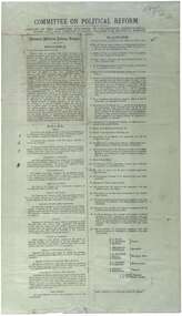
Printed report of the Committee appointed by the Congress to draft a scheme for political reform - the National Political Reform League, 1891
Political reform was high on the agenda of Australian Congress Committees. The report includes the preamble, rules and platform. Ballarat was chosen as the venue for the important 7th Intercolonial Trade Union Congress of Australia in April 1891 at which certain resolutions concerning political action by the workers were passed. The 7th Intercolonial Trades Union Congress in Ballarat is considered to be the beginnings of the Victorian Labor Party and mapped out 'One Big Union' which ultimately led to the formation of the ACTU.Relates to the history of the BTLC, political reform and other Australian Congress Committees - see 0019-26.Paperballarat trades hall, ballarat trades and labour council, political reform, australian congress committees, btlc, national political reform league, 7th intercolonial trades union congress, labor party - victoria, alp, one big union, actu -
 Ballarat Heritage Services
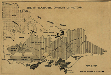
Map, Physiographic Divisions of Victoria, c1940, c1940
... Office goldfields victoria map physiography Physiographic map ...Physiographic map of Victoriavictoria, map, physiography -
 Ballarat Heritage Services
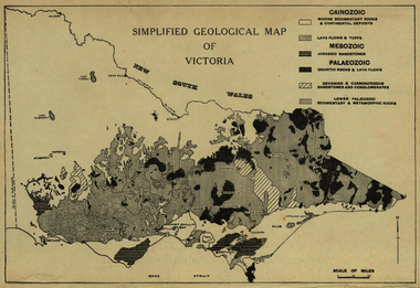
Map, Simplified Geological Map of Victoria, c1940, c1940
... Office goldfields victoria map geology geological Physiographic ...Physiographic map of Victoriavictoria, map, geology, geological -
Ballarat Heritage Services
Booklet, Rev. C.G. Schmidt, The Lutheran Church in Castlemaine also Yandoit and Maldon, c1986
Eighteen page booklet on the Lutheran church in and around Castlemaine. castlemaine, yandoit, maldon, lutheran church, pastor munzel, pastor leypoldt, german australians, map of castlemaine -
 Ballarat Heritage Services
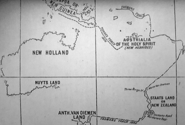
Photograph - Map, A Sketch from Dalyrmples Map of 1767, 1767
... Office goldfields map new holland hollandia nova isaac de graaff ...Copy of a map showing the coast that was known during the voyge of the Endeavour, and the first map that marks Torres track.map, new holland, hollandia nova, isaac de graaff, new guinea, australia of the holy spirit, papua, new hebrides, new zealand, nuyts land, van dieman's land, tasman's track, torres -
 Ballarat Heritage Services
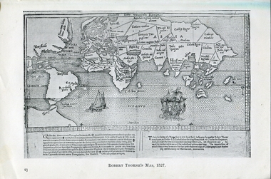
Photograph - Map, Robert Thorne's Map, 1527, 1527
... Office goldfields This map serves the purpose of proving ...This map serves the purpose of proving that Thorne and the Spanish geographers knew nothing about a continent near Australia.Copy of a map from 'A Short HIstory of Australia' by Ernest Scott.map, robert thorne, robert thorne's map, spanish explorers -
 Ballarat Heritage Services
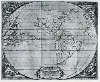
Map, Map Published at Paris, 1587, 1527
... Office goldfields This map shows a portion of New Guinea ...This map shows a portion of New Guinea, but the plae occupied by Austrlai was left as open ocean.Copy of a map from 'A Short HIstory of Australia' by Ernest Scott.map, paris map, new guinea, early australian mapping