Showing 23777 items
matching sardine-creek
-
 Greensborough Historical Society
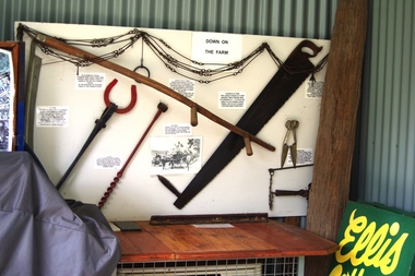
Photograph - Digital image, Marilyn Smith, Ellis Cottage, May 2016: Farm Implement Display, 27/05/2016
In May 2016, the Nillumbik Historical Society invited Greensborough Historical Society to visit its historical centre at Ellis Cottage in Diamond Creek. Ellis Cottage was built in 1865 and is made of local uncut stone. The cottage is a typical farmers residence of this period. The stone construction is unique in this district as most construction is weatherboard. This photo shows a farm implement display in the Historical Centre.Digital colour photographellis cottage, nillumbik historical society inc. -
 Greensborough Historical Society
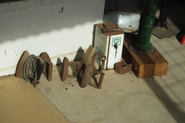
Photograph - Digital image, Marilyn Smith, Ellis Cottage, May 2016: Collection of Irons, 27/05/2016
In May 2016; the Nillumbik Historical Society invited Greensborough Historical Society to visit its historical centre at Ellis Cottage in Diamond Creek. Ellis Cottage was built in 1865 and is made of local uncut stone. The cottage is a typical farmers residence of this period. The stone construction is unique in this district as most construction is weatherboard. This photo shows a collection of irons on display in the Historical Centre.Digital colour photographellis cottage, nillumbik historical society inc. -
 Greensborough Historical Society
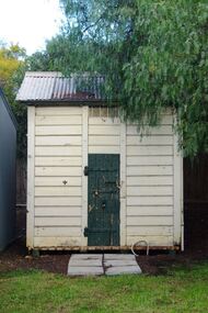
Photograph - Digital image, Marilyn Smith, Ellis Cottage, May 2016: Outside building, 27/05/2016
In May 2016, the Nillumbik Historical Society invited Greensborough Historical Society to visit its historical centre at Ellis Cottage in Diamond Creek. Ellis Cottage was built in 1865 and is made of local uncut stone. The cottage is a typical farmers residence of this period. The stone construction is unique in this district as most construction is weatherboard. This photo shows a small outside building in the grounds of the Historical Centre.Digital colour photographellis cottage, nillumbik historical society inc. -
 Greensborough Historical Society
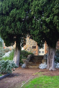
Photograph - Digital image, Marilyn Smith, Ellis Cottage, May 2016: Steps to front, 27/05/2016
In May 2016, the Nillumbik Historical Society invited Greensborough Historical Society to visit its historical centre at Ellis Cottage in Diamond Creek. Ellis Cottage was built in 1865 and is made of local uncut stone. The cottage is a typical farmers residence of this period. The stone construction is unique in this district as most construction is weatherboard. This photo shows steps to front door of Ellis Cottage.Digital colour photographellis cottage, nillumbik historical society inc. -
 Eltham District Historical Society Inc
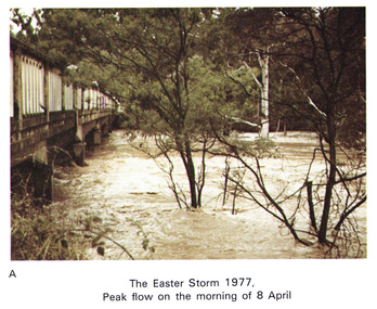
Work on paper (Sub-Item) - Photograph, Main Road Bridge, Eltham peak flow of flood 8 April, 1977
Colour photograph. Flooding of Diamond Creek at Main Road Bridge, Eltham peak flow of flood. Easter storm, 8 April, 1977flood, diamond creek, flooding, eltham, bridge, main road -
 Hume City Civic Collection
Photograph, 1990-1999
Two viaduct bridges were constructed across the Jacksons Creek valley at Rupertswood on the Bendigo rail line to bring the trains down the steep incline into Sunbury station.A photograph of the railway viaduct bridge showing one end of the span and 4 of the pylons. This bridge crosses the Jackson's Creek near one of the waterfalls which have been constructed in the creek. A large tree trunk is in the foreground of the photograph.rupertswood, clarke, william (sir), rupert (sir), michael (sir), victorian railways, salesian college, railways, bridges, jacksons creek, sunbury railway station, sunbury, george evans collection -
 Orbost & District Historical Society
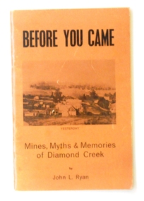
book, New Life Publication, Before You Came, 1972
This book is a history of Diamond Creek from earliest records of white visitors (1836) to the 1970s. John Ryan was born in Diamond Creek and lived there all of his life. (ref. Greensborough Hist. Society)This item is a useful research tool on the history of the Diamond Creek area, Melbourne, and its early pioneers.A thin soft cover book of 55 pp with a light brown cover with the title "Before You Came" in black print. Beneath this is a b?w copy of an early drawing of Diamond Creek. On the back cover is a photo of the same area in 1972. It contains a brief history and anecdote of the early days of Diamond Creek, Victoria.diamond-creek-history ryan-john-l. -
 City of Kingston
Photograph - Colour, Paul Tresize, 1998
The name Mordialloc was derived from the name Moody Yallock, which comes from the Bunurong language. The Bunurong Peoples are the Traditional Owners of this area. The name means “high water” or “high creek”. In 1839, colonial authorities declared the mouth of the creek, and an additional 830 odd acres as an Aboriginal Reserve, although this proclamation was never gazetted. The reserved land included part of the Carrum Carrum Swamp which was abundant with wild life and natural resources. Regular encroachments, including land sales which began in 1863, were made on the land until 1878 when the Reserve was declared closed, and the land was opened up to land sales. Market gardening and suburban house lots quickly began to develop, and Mordialloc became a renowned picnic and holiday site. Mordialloc Creek is a popular bay side destination for local and visitors, and is a site for boating, kayaking, fishing and swimming, along with many other activities.Colour photograph of Mordialloc Creek with boats moored on both sides of the street and Pompei's boat yard visible on the right hand side of the creek., Main Street and St Brigid's Catholic Church are visible in backgroundmordialloc, bunurong, traditional owners, suburbs, boats, fishing, waterways, hotel, church -
 City of Kingston
Photograph - Colour, Paul Tresize, 1998
The name Mordialloc was derived from the name Moody Yallock, which comes from the Bunurong language. The Bunurong Peoples are the Traditional Owners of this area. The name means “high water” or “high creek”. In 1839, colonial authorities declared the mouth of the creek, and an additional 830 odd acres as an Aboriginal Reserve, although this proclamation was never gazetted. The reserved land included part of the Carrum Carrum Swamp which was abundant with wild life and natural resources. Regular encroachments, including land sales which began in 1863, were made on the land until 1878 when the Reserve was declared closed, and the land was opened up to land sales. Market gardening and suburban house lots quickly began to develop, and Mordialloc became a renowned picnic and holiday site. Mordialloc Creek is a popular bay side destination for local and visitors, and is a site for boating, kayaking, fishing and swimming, along with many other activities.Colour photograph of Mordialloc Creek with boats moored on both sides of the street and Pompei's boat yard visible on the right hand side of the creek., Main Street and St Brigid's Catholic Church are visible in background.mordialloc, bunurong, traditional owners, boats, fishing -
 Old Gippstown
Building - School, c.1888
2903 SUNNY CREEK formerly YARRAGON EAST. Sunny Creek State School, first called Yarragon East, was situated on Sunny Creek Road between Yarragon and Trafalgar and was opened in 1888. It was generally served by two teachers or a Head Teacher assisted by a Sewing Mistress. Edwin Mann taught there for 35 years, with his wife, Mrs Mann, as the Sewing Mistress for some years. [Extracted from Vision and Realisation: A Centenary History of State Education in Victoria, Vol. 3, 1973. This does not contain any details of the actual construction of the school, which is a typical Education Department building, and may date from later than 1888]High local historic significance, with some social significance: reunions of old students still held. (Dr Linda Young, Deakin University, significance assessment July 2009).Single-classroom State School. It is a rectangular-shaped timber building with weatherboard walls, timber frame and corrugated iron roof. An outside verandah is situated along the side of the building. Inside there is a small entry porch, a blackboard the length of the room (with fireplace) and a small store-room/cloak room. Built in 1888Has a name broad above the front window that reads " SUNNY CREEK SCHOOL SS2903" ON IT.school, sunny creek, old gippstown, west gippsland, gippsland, gippsland heritage park, city of latrobe council, goldfields, coal mines, victorian era, moe, historical village, education, sunny creek road, baw baw shire, yarragon east, broad of education. -
 Falls Creek Historical Society
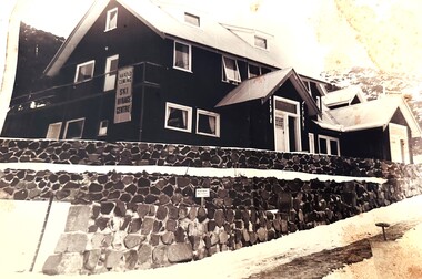
Photograph - Harold Cuming Ski Hirage Centre
Cuming's Ski Hire was an early establishment in Falls Creek, owned and operated by Harold and Jean Cuming. Located in Main Falls Creek Road only 70 yards from the top station of the chairlift, it had a wide range of skis for hire and many other accessories for sale. It also operated simple accommodation, a cafe and apres ski shop. The business changed hands and the cafe had many names throughout its history. It was the centre of many activities - including skiers using the roof as a ski jump!This image is significant because it depicts the original Cumings Ski Hire building at Falls Creek, Victoria.A black and white photo of the Harold Cuming Ski Hirage Centre at Falls Creek.On sign on wall: Harold Cuming Ski Hirage Centrecuming's ski hire, harold cuming, jean cuming, ski hire falls creek -
 Mt Dandenong & District Historical Society Inc.
Photograph, The Crescent Bridge, Sassafras
Photograph taken at the bottom of the hill on 'The Crescent' at Sassafras where the Crescent Bridge crosses the Sassafras Creek.Black and white cop of a photograph showing a bridge crossing an unmade road over creek. Bush in background.sassafras, sassafras creek, crescent bridge, bridge, the crescent, bush, tree ferns -
 Falls Creek Historical Society
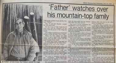
Article - "Father" watches over his mountain-top family, 30 July 1986
This article acknowledged the naming of Ory's Trail at Falls Creek in 1986. Orest “Ory” Frueauf was born in Kharkov, Russia in 1925 and moved to Germany with his family to escape persecution. He was conscripted to the German Army during the Second World War. He was a POW until 1948. He was recruited by a French construction company to work as and interpreter on a hydroelectricity project in Tasmania. Ory then moved to work on the Snowy Mountain Scheme including driving a truck to fill the wall of the Rocky Valley dam. In 1952 Ory was recruited by the Albury Ski Club as its lodge supervisor. That year he also entered into a business partnership with Cecil Dobson, running the general store “Whitehaven” and Post Office at Falls Creek. They extended their business by adding accommodation turning Whitehaven into one of the best commercial lodges at Falls Creek. Ory and Cecil dissolved their business partnership in 1963 and Ory went on to build a new lodge called “Snowhaven” at the site of the present day Frueauf Village, Falls Creek. Ory retired to Tawonga, Victoria in 1992 and passed away in 1999.This article is significant because it documents the naming of Ory's Trail to recognise a pioneer of Falls Creek.A newspaper item about Ory Freauf on the occasion of the naming of Ory's Trail at Falls Creek.falls creek pioneers, frueauf, ory frueauf -
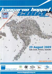
 Falls Creek Historical Society
Poster - Kangaroo Hoppet 2012
The Kangaroo Hoppet is Australia’s premier long distance cross country ski race, and a member of the Worldloppet series of international cross country ski events. The first race at Falls Creek was held in 1979 under the name of “Australian Birkebeiner”. It was a 21km race with about 80 participants organised by the Birkebeiner Nordic Ski Club of Mount Beauty. The course started and finished at Falls Creek Alpine Resort and took participants out into the Bogong High Plains. After running the event for 10 years, it was decided they should become part of the Worldloppet series of marathon ski races. Representatives from the Birkebeiner Nordic Ski Club and the Australian Ski Federation attended the Worldloppet Annual Meeting in Finland in June 1990 to put the case for the acceptance of an Australian event into the Worldloppet series. Before being admitted, they had to demonstrate that the Birkebeiner Club could run a world class event, so three months later in August 1990 a 42km event named the Australian International Ski Marathon was held at Falls Creek together with a 21km Birkebeiner race and a 7km event called the Birkebeiner Lite. The event was approved by delegates from USA, Norway and Austria, in 1991 Australia became the 12th member of Worldloppet, with the condition that there had to be a name change. After some late night discussion allegedly involving red wine from North East Victoria the main event became the 42km Kangaroo Hoppet, with the minor events being the 21km Australian Birkebeiner, and 7km Joey Hoppet. In the winter of 1991, the first Kangaroo Hoppet was held. It was a great success and has been a regular fixture on the international ski calendar ever since. It features the main 42km event as well as a 21km event and a 7km event. The Hoppet brings the Australian snowfields to an international audience. In 2012 the Men's Winner was Alexander Legkov from Russia in a time of 1:23:00. The winner of the Women's event was Maria Graefnings of Sweden in a time of 1:33:14. The planned course was modified and shortened due to the predicted high winds and poor visibility. The 42km Hoppet course was shortened to 30km.This poster is significant because it documents an event which brings international attention to Falls Creek and the surrounding region.A poster featuring a skier dressed in blue and red with trees in the background. Stylised snowflakes are on either side. The page border is red. Logos of AGL, Falls Creek All Season Alpine Resort, Alpine Shire, Tourism Victoria, Parks Victoria and the Birkebeiner Nordic Ski Club are across the bottom of the poster.At the top right hand corner within a circle: Australia's PREMIER X-COUNTRY SKI RACE 22 Beneath the image KANGAROO HOPPET 25th August 2012 FALLS CREEK VICTORIA AUSTRALIA / 42KM 21KM 7KM / www.hoppet.com.au kangaroo hoppet, worldloppet events, falls creek, mt. beauty -
 Lorne Historical Society
Photograph, Great Ocean Road. Tollgate and house
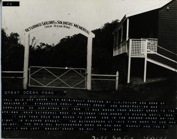
The toll gate and house was erected at Stradbroke Knoll, Grassy Creek by JC Taylor and sons of Geelong . Construction was completed on Christmas Day 1922. It was moved from Grassy Creek to Cathedral Rock in October 1929 where it stayed until 1936. It was then sold and moved to Lorne. It is the second house on the right in Minapre Street. The Gatehouse keepers at the time were Mr and Mrs Wright. The original Gatekeepers were Mr and Mrs MacKay. They left Grassy Creek with their family on 11 May 1926The GOR Tollgate and house were originally erected by J.C. Taylor and Sons of Geelong, at Stradbroke Knoll, Grassy Creek and construction was completed on Christmas Day 1922. It was moved from Grassy Creek to the Springs at Cathedral Rock in October 1929 where it stayed until 1936, It was then sold and moved to Lorne. It is the second house on the right in Minapre Street. The gatehouse keepers at this time were Mr. & Mrs.Wright. The original gatekeepers were Mr & Mrs Mackay. They left Grassy Creek with their family on 11th May 1926j.c. taylor and sons. gor, tollgate. -
 Hume City Civic Collection
Photograph, 1970s
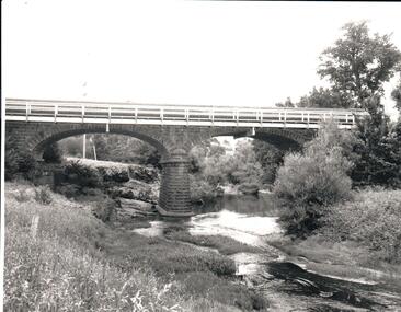
The bluestone bridge which spans the Jacksons Creek was built in 1857 and replaced a laminated timber bridge. In the 1970s the stone bridge was replaced with a wider cement structure to accommodate the increased traffic flow.A black and white photograph of the bluestone Macedon road bridge over the Jacksons Creekmacedon street road bridge, harris, thomas lascelles, jacksons creek, george evans collection -
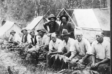 Halls Gap & Grampians Historical Society
Photograph - Sepia
Grampians Halls Gap & Stoney Creek dredge. circa 1909 . 2nd man from right is Alfred D'/alton; 4th from right is James OliverPhoto shows eight men seated, two standing. 3 tents in background.Grampians Hallls Gap & Stoney Creek dredge circa 1909 written on backpeople, d'alton, water supplies, channels -
Bendigo Historical Society Inc.
Booklet - Axe Creek Rural Fire Brigade - 75th Anniversary 1912-1987, 1987
The Axe Creek Bush Fire Brigade was formed in 1912 with each landowner contributing 1/- per year. By 1920 the brigade had amassed equipment consisting of rakes, brooms, a 100 gallon water tank and a hand pump. In 1948 it's name changed to the Axe Creek Rural Fire Brigade.20-page soft blue cover booklet with logo on front cover. 'Axe Creek Rural Fire Brigade - 75th Anniversary 1912-1987 Printed by Sloans Printery, Bendigo and Published by the Axe Creek R.F.B. Committee. History of the Fire Brigade illustrated with B&W photos. Handwritten in ink on page 1 'Regards Craig Houlahan' and on page2 'Regards W Houlahan'axe creek, rural fire brigade -
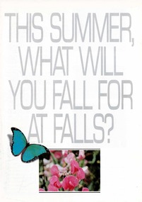 Falls Creek Historical Society
Booklet - This Summer, What Will You Fall For at Falls?
A part of a yearly marketing and information material promoting Falls Creek region for the summer holidays. The brochure outlines active and more relaxing options available at Falls Creek in the summer of 1989 - 90. Accommodation featured on the back cover includes:-Nelse Lodge, Falls Creek Motel, Viking, Lakeside LOdge, Winterhaven Lodge, Astra Lodge and Cooroona Ski Lodge.This item is important because it documents seasonal activities at Falls Creek Alpine ResortWhite A4 brochure for Summer at Falls Creek. White cover with grey title in capital letters - THIS SUMMER, WHAT WILL YOU FALL FOR AT FALLS? - with ba blue butterfly and framed image of pink flowers centred underneath. Opens to A3 size with internal double page and back page spread of images and information of Summer at Falls Creek. falls creek marketing, falls creek summer, accommodation falls creek -
 Lakes Entrance Regional Historical Society (operating as Lakes Entrance History Centre & Museum)
Photograph, 1999
A sawmill was situated on the flat where the creek enters the lake, timber brought to the mill by horse drawn trolley on tramway beside creek.Colour photograph of Maringa Creek, Nungurner. looking towards the lake. Shows a waterway meandering amongst swampy flats and tree covered banks. Nungurner Victoriahalls -
Whitehorse Historical Society Inc.
Document, My memories of the area around Simpson Park, 1/10/2003 12:00:00 AM
Memories with promptings from Jack Leach who lived in Rupert Street and later in Creek Road.Memories with promptings from Jack Leach who lived in Rupert Street and later in Creek Road. Describes that part of Mitcham south of the railway line between Creek Road and Cochrane street. A sketch map of the area as it was in the 1930's is also supplied.Memories with promptings from Jack Leach who lived in Rupert Street and later in Creek Road.brunswick road, mitcham, creek road, mitcham, cochrane street, mitcham, rupert street, mitcham, bloom family, leach, jack, leach family, simpson family, ferris, ray, simpson park -
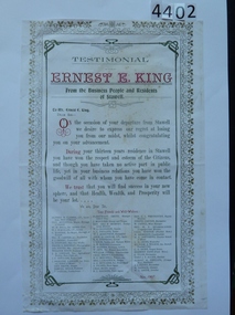 Stawell Historical Society Inc
Memorabilia - Realia, Ernest E. King Testimonial, 1907
Copy of Ernest E. King Testimonial on his departure from Stawell after 13 years employment at Stawell New & Pleasant Creek ChronicleReverse: Photocopy Stawell News & Pleasant Creek Chronicle article, 26/11/1907. Letter of donation from Terang & District Historical Society 1/3/ 2012 stawell -
 Falls Creek Historical Society
Poster - Kangaroo Hoppet 2009
The Kangaroo Hoppet is Australia’s premier long distance cross country ski race, and a member of the Worldloppet series of international cross country ski events. The first race at Falls Creek was held in 1979 under the name of “Australian Birkebeiner”. It was a 21km race with about 80 participants organised by the Birkebeiner Nordic Ski Club of Mount Beauty. The course started and finished at Falls Creek Alpine Resort and took participants out into the Bogong High Plains. After running the event for 10 years, it was decided they should become part of the Worldloppet series of marathon ski races. Representatives from the Birkebeiner Nordic Ski Club and the Australian Ski Federation attended the Worldloppet Annual Meeting in Finland in June 1990 to put the case for the acceptance of an Australian event into the Worldloppet series. Before being admitted, they had to demonstrate that the Birkebeiner Club could run a world class event, so three months later in August 1990 a 42km event named the Australian International Ski Marathon was held at Falls Creek together with a 21km Birkebeiner race and a 7km event called the Birkebeiner Lite. The event was approved by delegates from USA, Norway and Austria, in 1991 Australia became the 12th member of Worldloppet, with the condition that there had to be a name change. After some late night discussion allegedly involving red wine from North East Victoria the main event became the 42km Kangaroo Hoppet, with the minor events being the 21km Australian Birkebeiner, and 7km Joey Hoppet. In the winter of 1991, the first Kangaroo Hoppet was held. It was a great success and has been a regular fixture on the international ski calendar ever since. It features the main 42km event as well as a 21km event and a 7km event. The Hoppet brings the Australian snowfields to an international audience. In 2009 the Men's Winner was Ben Sim from Australia in a time of 0:58:39.4. The winner of the Women's event was Kate Calder of New Zealand in a time of 1:07:48.9. Due to the poor weather, and in view of skier safety and poor snow cover, a modified course was set. he Hoppet was reduced from 42 to 25 kms. This poster is significant because it documents an event which brings international attention to Falls Creek and the surrounding region.A poster with an aerial photo of a large number of skiers in the formation of the shape of a kangaroo. The colour of the border is blue, white and orange text is used. The Worldloppet logo is at the top left. The logos of AGL, Alpine Shire, Birkebeiner Nordic Ski Club, Parks Victoria, Tourism Victoria and Falls Creek are across the bottom of the poster. At the top: KANGAROO HOPPET 2009 NINETEEN At the foot of the kangaroo shape: 29 AUGUST 2009 FALLS CREEK, VICTORIA, AUSTRALIA In orange text: KEEP WINTER COOL FIGHT GLOBAL WARMING WWW.KEEPWINTER COOL.COM.AU At bottom in white text: www.hoppet.com.au kangaroo hoppet, worldloppet events, falls creek, mt. beauty -
 Halls Gap & Grampians Historical Society
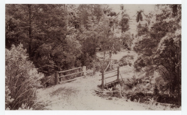
Photograph - B/W, C 1940- (before 1950)
Stoney creek has been 'bridged' a number of times in School Rd, since the creek was re-routed in the early 1900's. A dray bridge was built c1910 by local residents which stood them in good stead for more than a decade.Photo of 'school bridge' over Stoney Creek. Gravel road in foreground leading to a wooden bridge surrounded by tall gum trees.structures, bridges -
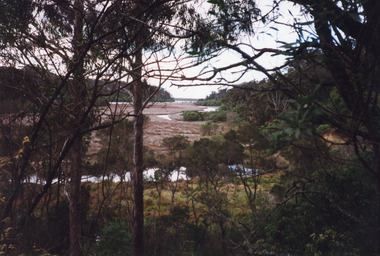
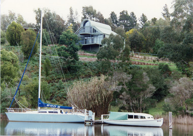 Lakes Entrance Regional Historical Society (operating as Lakes Entrance History Centre & Museum)
Photograph, 1994 c
Box's Creek named after Judge Box, early residentColour photograph taken from Box's Creek, showing a modern dwelling on the hillside, a yacht and motor launch at jetty. Metung Victoriawaterways, houses, boats and boating, retail trade, hotels -
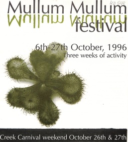 Whitehorse Historical Society Inc.
Article - Pamphlet, Mullum Mullum Festival, 1/10/1996 12:00:00 AM
Programme for three weeks of activities at the 1996 Mullum Mullum Festival, 6th - 27th October.Programme for three weeks of activities at the 1996 Mullum Mullum Festival, 6th - 27th October. Creek Carnival weekend, October 26th & 27th.Programme for three weeks of activities at the 1996 Mullum Mullum Festival, 6th - 27th October. parks and reserves, schwerkolt cottage, cameron, david, simpson, ken, cooper, pat, cooper, mike, manningham creek, hillcrest reserve, mullum mullum creek, taylor, cameron, lang, felicity, currawong bush park, city of manningham, city of whitehorse -
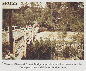 Eltham District Historical Society Inc
Work on paper (Sub-Item) - Photograph, Flooding, View of Diamond Street Bridge, Eltham 8 April 1977
Colour photograph. Flooding of Diamond Creek at Diamond Street Eltham bridge approximately 2 1/2 hours after the flood peak. Note debris on the bridge deck. 8 April 1977. flood, diamond creek, flooding, eltham, diamond street, bridge -
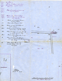 Victoria Police Museum
Map (Thomas McIntyre), 1878 - 1880
Created by Constable Thomas McIntyre, sole survivor of the police party murdered by the Kelly Gang at Stringybark Creek near Mansfield Victoria in 1878. Thomas McIntyre was the main witness in Ned Kelly's trial.Large hand drawn map of the Stringybark Creek ambush site on blue government paper.ned kelly, kelly gang, victoria police, thomas mcintyre, stringybark creek, thomas lonigan, michael kennedy, thomas scanlan -
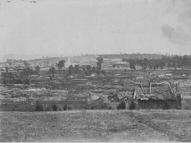 The Beechworth Burke Museum
Photograph, 1865
This image was taken of the diggings at Spring Creek. In February 1852 gold was discovered at Spring Creek, Beechworth. Within eleven months of this discovery, over 8000 hopeful prospectors had descended on the region, transforming the seemingly undisturbed land into what a visiting journalist in 1880s referred to as; "A Titan's Field". Huge mounds of earth were churned by hundreds of miners in search for gold, almost every available resource the land had to offer was used for something; even the bark off the gums were stripped to line huts and shafts. By 1857 more than 20,000 people lived in Beechworth, and with this influx the town prospered with the building of numerous churches, banks, schools, shops and hotels along with a prison and hospital.Black and white rectangular photograph. Image is printed on matte photographic paper and is mounted on cardboard. Obverse: NO INSCRIPTION Reverse: BMM6926 / BEECHWORTH FROM SPRING CREEK 1865 spring creek, beechworth, burke museum, 1865, gold rush -
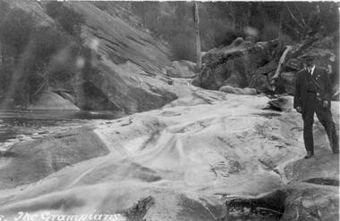 Halls Gap & Grampians Historical Society
Photograph - Sepia, C 1920s
Photo is probably a copy of a postcard. A caption "The Grampians " is written bottom left. The creek is Stoney creek/site Venus Baths.Photo shows man standing by a swiftly flowing creek. He is standing on a rocky platform. Slabs of rock can be seen in background. The man is wearing a cap with suit and tie.Quality paper made in Germanyscenery, stoney creek