Showing 8323 items
matching the bridge
-
 Bendigo Historical Society Inc.
Book - BENDIGOS BRIDGE STREET BURIAL GROUND, 2010
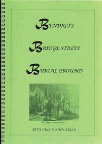
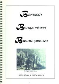
Bendigo's Bridge Street Burial Ground. 53 pages in a spring bound folder containing black and white photographs and maps.Rita Hull & John Kellybendigo, history, cemetery, bendigo-history-cemetery -
 Port Melbourne Historical & Preservation Society
Photograph - Construction of Bolte Bridge, Ron Laing, 1986 - 1999
Part of Ron Laing's collection of photographs recording Port Melbourne over a thirteen year period. Donated to the PMH&PS by the photographer.A set of 36 colour photographs covering the construction of the Bolte Bridge and approaches from the West Gate Freeway in Port Melbourneengineering - bridges, ron laing -
 Port Melbourne Historical & Preservation Society
Photograph - Heath Street, Port Melbourne, 1980
B&W photo of Heath Street looking south towards Bridge Street c 1980 (view from rooftop)built environment - domestic, antonio cannatelli, heath street -
Port Melbourne Historical & Preservation Society
Photograph - Lasercopy, Group outside 'Alandale', 264 Bridge Street, Port Melbourne, c. 1910
Photographs taken around Port Melbourne. Early 1900s Family group standing outside "Älandale" at 264 Bridge Stfamilies, built environment - domestic, schmidt family, isobel munday -
Port Melbourne Historical & Preservation Society
Photograph - Former Station Hotel, Bridge and Station Streets, Port Melbourne, David Thompson, 1990s
One of five colour photographs of Port Melbourne streets: Former Station Hotel at Bridge and Station Streets, converted to flats.built environment - commercial, bay street -
 Bendigo Historical Society Inc.
Book - BENDIGO'S BRIDGE STREET BURIAL GROUND
Bendigo's Bridge Street Burial Ground, 53 pages in a spring bound binder with black and white photographs, maps & illustrations.Rita Hull & John Kellybook, bendigo, cemeteries, bendigo-history-cemeteries -
 Bendigo Historical Society Inc.
Photograph - WES HARRY COLLECTION: PRESBYTERIAN CHURCH, 1853
Photograph of an artwork (drawing ?) of the Presbyterian church, Bridge Street in 1853. Stamped on the rear ' From the original in the Mitchell Library, Sydney. 'buildings, church, presbyterian church, bridge street, presbyterian church, bridge street -
 Hume City Civic Collection
Photograph
Two men are standing on the swing bridge which was constructed across Deep Creek at Bulla. The river and opposite riverbank are in the foreground.bulla, deep creek, bridges, swing bridge, george evans collection -
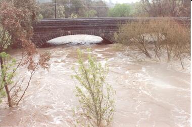 Hume City Civic Collection
Photograph
The series of photographs were taken after exceptional heavy rain had fallen in Sunbury in the early 1990s. Jackson's Creek overflowed its banks and the surrounding flood plain area was under water.A coloured photograph of Jackson's Creek in flood. The floodwaters have almost reached the top of the arch of the Macedon Street stone bridge.floods, weather patterns, jacksons creek, george evans collection -
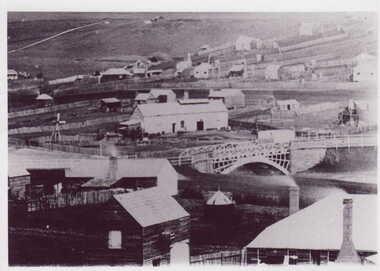 Clunes Museum
Photograph
BLACK & WHITE PHOTOGRAPH GENERAL VIEW CLUNES TOWNSHIP WITH GOVERNMENT BRIDGE IN CENTRE OF PHOTOGRAPH, EBERHARD SOFT DRINK FACTORYphotographs, township, goverment bridge -
Whitehorse Historical Society Inc.
Newspaper, Box Hill Railway Gates / Box Hill Siding for Box Hill Brickworks, 14/01/1915 12:00:00 AM
Two letters to the editor concerning the possibility of replacing the gates with an overhead bridge.Two letters to the editor concerning the possibility of replacing the gates with an overhead bridge, also providing a siding for the Box Hill brickworks.Two letters to the editor concerning the possibility of replacing the gates with an overhead bridge. railway crossings, brickworks, box hill railway station -
 Whitehorse Historical Society Inc.
Photograph, Blackburn Lake Sanctuary
Walking track over an offshoot of the Blackburn Lake which can be seen in the behind the trees. An adult pushing a pram and a bridge.blackburn lake sanctuary -
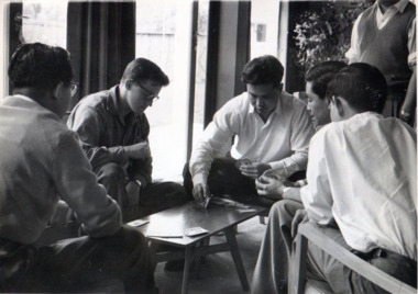 International House, The University of Melbourne
Photograph (Item), Richard Shiell, 10 Ways of Filling in Time at International House - 4: "One Quick Rubber (Bridge was very popular)", 1960
A quiet moment playing cards in the Common Room, this photo illustrates the many benefits International House presented to its residents, giving space for social and everyday interactions with diverse peoples, to the benefit and enjoyment of all. This photograph comes from an 'Album of Student Activities 1960', compiled and presented to International House by Soedjadi Satrosoegito & Richard Shiell.social, card games -
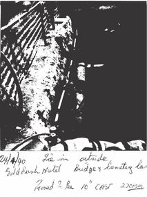 Bendigo Historical Society Inc.
Photograph - CASTLEMAINE GAS COMPANY COLLECTION: PHOTO GOLD RUSH HOTEL, 24/01/1990
Tie in Outside Gold Rush Hotel Bridge and Cemetery Lane Thought to be 10'' Cast 270mm. - 24/01/1990Polaroidorganisation, industry, gas and fuel -
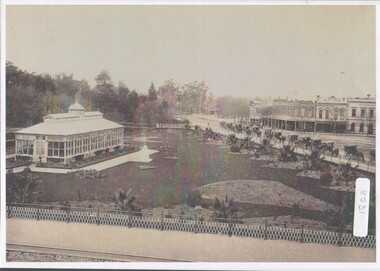 Bendigo Historical Society Inc.
Photograph - Bendigo Conservatory and gardens
Fifty nine acres of land was reserved for a park in1861, and the first gardener began setting out the gardens in 1870. The conservatory was built in 1897 and is the last building of its type in a public park.The conservatory was designed by Mr G. Minto, city surveyor at the time. The building is 72 feet long and 24 feet wide. The walls re twenty two feet high and are topped by a lantern roof, adding a further six feet. It was built at a cost of between 700 and 800 pounds.B&W photograph with view over the Bendigo Conservatory and gardens with a line of twelve horse drawn cabs on Bridge Streetconservatory gardens, bendigo -
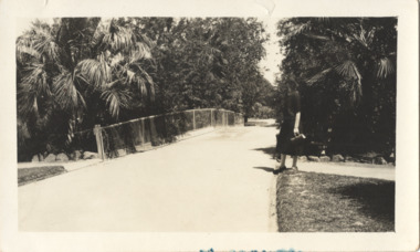 Kew Historical Society Inc
Photograph - In the 'Alexandra Gardens', Kew, 1927
The Alexandra Gardens in Cotham Road, Kew were opened by the Governor of Victoria in 1910. The first curator of the gardens was George Pockett, who with his brother is credited with the layout of the gardens. The gardens were constructed on land originally owned by the King family of 'Madford' in Wellington Street. The land on which the gardens were developed was originally the back paddock of 'Madford' which was purchased by the Borough of Kew in 1906.A rare and early photograph of the gardens showing clearly the changes to the layout and planting during the 1920s. Small, sepia coloured photographic positive of a woman standing beside a path and bridge in the Alexandra Gardens in Cotham Road, Kew.Annotation verso: "Alexandra Gardens Kew 1927"parks and gardens -- kew (vic.), alexandra gardens -- kew (vic.), george pockett -
Tarnagulla History Archive
Photograph - Photograph: Damaged Laanecoorie Bridge, 1909
Williams Family Collection. Monochrome photograph depicting the remains of the Laanecoorie Bridge after much of it was washed away by floods in 1909. Appears to be a copy photograph. tarnagulla -
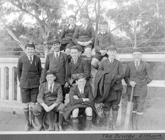 St Patrick's Old Collegians Association (SPOCA)
Photograph - Students, 1920s
-
City of Kingston
Photograph - Colour, Paul Tresize, 1998
The name Mordialloc was derived from the name Moody Yallock, which comes from the Bunurong language. The Bunurong Peoples are the Traditional Owners of this area. The name means “high water” or “high creek”. In 1839, colonial authorities declared the mouth of the creek, and an additional 830 odd acres as an Aboriginal Reserve, although this proclamation was never gazetted. The reserved land included part of the Carrum Carrum Swamp which was abundant with wild life and natural resources. Regular encroachments, including land sales which began in 1863, were made on the land until 1878 when the Reserve was declared closed, and the land was opened up to land sales. Market gardening and suburban house lots quickly began to develop, and Mordialloc became a renowned picnic and holiday site. Mordialloc Creek is a popular bay side destination for local and visitors, and is a site for boating, kayaking, fishing and swimming, along with many other activities.Colour photograph of Mordialloc Creek, looking inland. Boats are moored on either side of the creek and the Bridge Hotel is visible in the background.mordialloc, bunurong, traditional owners, suburbs, boats, fishing, waterways, hotel -
Port Melbourne Historical & Preservation Society
Photograph - Former corner shop, 207 Ross Street at Bridge Street, Jan 2002
This heritage property will be developed. Originally it was a mixed business - grocery, greengrocer, milk bar and newsagent. In the 1960s it became a grocery only, before closing down to become a residence. Three colour photographs of the 'Corner shop' 207 Ross Street at Bridge Street, now a residence only. January 2002.built environment -
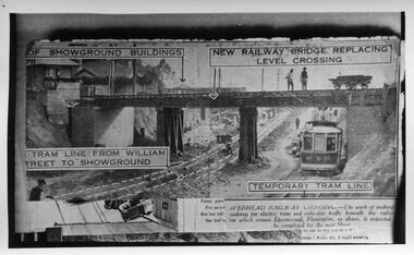 Melbourne Tram Museum
Photograph - Black and White, Epson Road Rail Bridge under construction, Early 1925
Image shows a newspaper photo of the MMTB U Class Tram 203 on temporary track at east side of excavation for underpass in Epson Road Flemington with Racecourse railway line to eliminate level crossing. The road was often closed to all traffic, including trams on race days by the railways. The work was completed in April 1925MMTB U Class trams were built for the former operator NMETL, with the photo showing an early level crossing abolition project. Black and White photo Epson Road Rail Bridge under construction with MMTB U Class tram on temporary track tramways, trams, epson road bridge, u class, flemington, tram 203 -
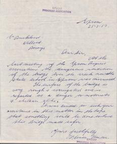 Bendigo Historical Society Inc.
Document - DOCUMENT. LETTER FROM EPSOM PROGRESS ASSOCIATION, 1957
Document. Letter from Epsom Progress Association, re condition of bridge over the creek near the Epsom State School.epsom, epsom progress association, epsom sate school -
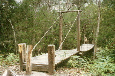 Lakes Entrance Historical Society
Photograph - Bridges, Fish Marie, 1995
Colour photograph of the suspension bridge at Mississippi Creek picnic area in Colquhoun State Forest near Lakes Entrance, Victoriabridges, vegetation -
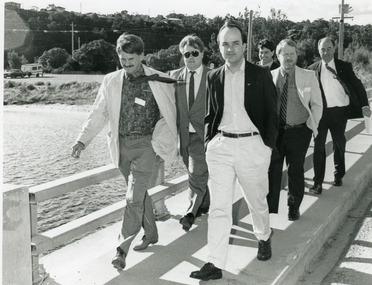 Lakes Entrance Historical Society
Photograph - Tambo Shire Councillors, Lakes Post Newspaper, 1990
Barry Secomb, Graeme Hill, Philip Davis MLC, David Treasure MLA, Mark Birrell Minister C and E during discussions on Bullock Island tourismBlack and White Photograph of Tambo Shire members and government of Bullock Island Bridge during discussion on Bullock Island tourismmuincipal history, people, tourism, bullock island -
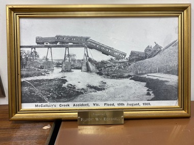 Clunes Museum
Photograph
Framed image of derailed train on trestle bridge. Metal engraved sign affixed to bottom of frame "Presented by WM Boxshall"McCallum's Creek Accident Vic Flood 19th August 1909 printed below image.train accident, 1909, flood 1909 -
 Eltham District Historical Society Inc
Album - Photograph, J.A. McDonald, Eltham-Greensborough Road, 29 July 1956
Diamond Creek Bridge (Bridge Street Bridge) Showing downstream cylinder pier No. 2 29th July 1956Record of various Shire of Eltham infrastructure works undertaken during the period of 1952-1962 involving bridge and road reconstruction projects, sometimes with Eltham Shire Council Project Reference numbers quoted. It was during this period that a number of significant improvements were made to roads and new bridges constructed within the shire that remain in place as of present day (2022). In many situations, the photos provide a tangible visible record of infrastructure that existed throughout the early days of the Shire. The album was put together by or under the direction of the Shire Engineer, J.A. McDonald.infrastructure, road construction, shire of eltham, bridge construction, bridge street bridge, eltham, eltham-greensborough road, 1956-07-29 -
 Eltham District Historical Society Inc
Album - Photograph, J.A. McDonald, Eltham-Greensborough Road, 31 July 1956
Diamond Creek Bridge (Bridge Street Bridge) Beam Pier No. 1 Showing formwork 31st July 1956Record of various Shire of Eltham infrastructure works undertaken during the period of 1952-1962 involving bridge and road reconstruction projects, sometimes with Eltham Shire Council Project Reference numbers quoted. It was during this period that a number of significant improvements were made to roads and new bridges constructed within the shire that remain in place as of present day (2022). In many situations, the photos provide a tangible visible record of infrastructure that existed throughout the early days of the Shire. The album was put together by or under the direction of the Shire Engineer, J.A. McDonald.infrastructure, road construction, shire of eltham, bridge construction, bridge street bridge, eltham, eltham-greensborough road, 1956-07-31 -
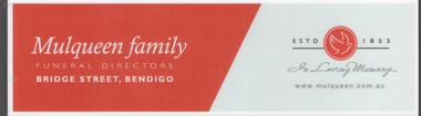 Bendigo Historical Society Inc.
Ephemera - MULQUEEN FAMILY COLLECTION: BOOK MARK
Book mark, red with white writing. On one side the words: Book Mark a little memento from the Mulqueen family, Bridge Street, Bendigo. On the other side: Mulqueen family, funeral directors, Bridge Street, Bendigo on the left and on the right, the logo of a dove flying estd. 1853. In loving memory. WWW.mulqueen.com.aubendigo, business, mulqueen -
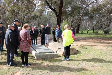 Bendigo Historical Society Inc.
Bendigo Historical Society Walking Tour of Axedale, 1st Sept 2024
Axedale is a town in Victoria, Australia. It is located on the McIvor Highway, in the City of Greater Bendigo, east of Bendigo. It was surveyed and proclaimed in 1861. At the 2021 census, Axedale had a population of 984. The town is nestled alongside the Campaspe River which feeds out of Lake Eppalock. It has a golf course, tennis courts, a school, a pub and a convenience store/petrol station. It lies between Heathcote and Bendigo.Forty Photos taken on the walking tour of Axedale by the Bendigo Historical society. Places visited included the Protestant and Catholic Cemeteries, the "Blue Stone House", the 150-year-old bridge over the Axe Creek on the Sugerloaf Road, the old Cobb and Co Stables, St Andrews Church and the Campaspe River Bridge.axedale, bendigo historical society walking tour, st andrews church axedale, axedale cemetery, axe creek bridge, campaspe, cobb and co stables axedale, blue stone house axedale -
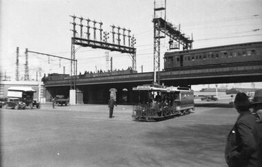 Melbourne Tram Museum
Negative, 1936
Negative of cable tram crossing from Queensbridge Road into Market St after passing under the railway underpass, along Flinders St. In the background is a the bridge with a Tait train crossing, a work or ballast train on the bridge and the signal gantry. There is a policeman on point duty. The cable tram has the destination of Collins St.trams, tramways, cable trams, flinders st, market st, collins st, railways