Showing 3404 items matching " 2000.522..01"
-
 Bendigo Historical Society Inc.
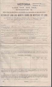
Document - KELLY AND ALLSOP COLLECTION: VICTORIA LAND TAX ACT 1910 - FORM, 31/12/1910 to 01/03/1911
Document. KELLY & ALLSOP COLLECTION. Three copies of Schedule B of Land Tax Act of Victoria 1910. 'Return of Land and Monies Owing on Mortgage of Land.' Each form partly filled out by Arthur Allsop in pencil, ie 'Particulars of Land' section. He owns two houses in Wills St and a vacant block of land at Pyke/Brodie Streets. Instructions to taxpayers 'Every owner of land must furnish a return before 1st March 1911 of all lands owned on 31 Dec 1910.'Taxation Office of Victoriabusiness, stockbroker, kelly & allsop, kelly & allsop collection, victoria land tax act 1910, schedule b -
 Bendigo Historical Society Inc.
Map - KANGAROO FLAT, 27/.01/1932
Map: Township of Kangaroo Flat, Parish of Sandhurst, County of Bendigo ( number 148 in Map Cupboard 1)map, bendigo, township, kangaroo flat, parish of sandhurst, county of bendigo -
Bendigo Historical Society Inc.
Map - HUNTLY, 7/01/1904
Map: Township of Huntly, Parish of Huntly, County of Bendigo ( number 150 in Map Cupboard 1)map, bendigo, township, huntly, parish of huntly, county of bendigo -
Bendigo Historical Society Inc.
Map - EAGLEHAWK (PART), 22/01/1882
Map: Parish plan showing area Eastward from Lightning Hill ( number 205 in Map Cupboard 1)map, bendigo, parish plan, eaglehawk, lightning hill -
Bendigo Historical Society Inc.
Map - TOWNSHIP OF KANGAROO FLAT, 27/01/1932
Map: Township of Kangaroo flat, Parish of Sandhurst , County of Bendigo. Parish plan ( number 194 in Map Cupboard 1)map, bendigo, township, kangaroo flat -
Bendigo Historical Society Inc.
Map - MUSKERRY, 23/01/1888
Map: Muskerry , County of Rodney. Parish plan. ( number 251 in Map Cupboard 1)map, rodney, parish plan, muskerry -
Bendigo Historical Society Inc.
Map - MUSKERRY, 23/01/1888
Map: Muskerry, County of Bendigo. Parish plan ( number 250 in Map Cupboard 1)map, bendigo, parish plan, muskerry -
Bendigo Historical Society Inc.
Map - MINTO, 10/01/1884
Map: Minto, County of Bendigo. Parish plan. ( number 248 in Map Cupboard 1).map, bendigo, parish plan, minto -
Bendigo Historical Society Inc.
Map - PORTION OF SANDHURST, 27/01/1877
Map: Hand draughted parish plan, showing a portion of the City of Sandhurst ( number 225 in Map Cupboard 1)map, bendigo, parish plan, sandhurst -
Bendigo Historical Society Inc.
Map - SALISBURY WEST, 29/01/1878
Map: Salisbury West, County of Gladstone. Parish plan (number 305 in map cupboard 1)map, gladstone, parish plan, salisbury west -
Bendigo Historical Society Inc.
Map - MINTO, /01/1884
Map: Minto, County of Bendigo. Parish plan (number 283 in map cupboard 1)map, bendigo, parish plan, minto -
Bendigo Historical Society Inc.
Map - EGERTON, 28/01/1896
Map: Parish of Egerton, County of Bendigo. Parish plan. (number 335 in map cupboard 1)map, bendigo, parish plan, egerton -
 Victorian Interpretive Projects Inc.
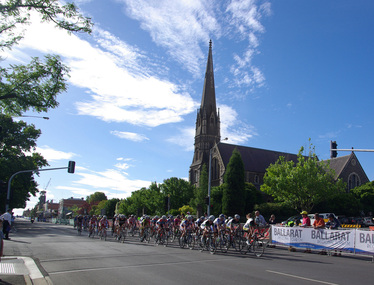
Photograph - Colour, Clare Gervasoni, Australian Road Cycling Championships, Ballarat, 05/01/2012
Each year the national cycling championships are held at Ballarat.Colour photograph in digital format of a number of female bicycle riders taking part in the National Road Cycling Championships at Ballarat. The church is St Andrew's Kirk, Sturt Street, Ballaratballarat, st andrew's, cycling, bicycle -
 Victorian Interpretive Projects Inc.
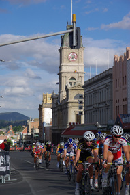
Photograph - Colour, Clare Gervasoni, National Cycling Championships, Ballarat, 05/01/2012
Each year the National Cycling awards are held in Ballarat.Colour photograph in digital format showing a number of female riders in the National Cycling Road Race, 2012. They are riding on Sturt Street and the Ballarat Town Hall is in the background.ballarat, ballarat town hall, cycling, bicycle -
 Victorian Interpretive Projects Inc.
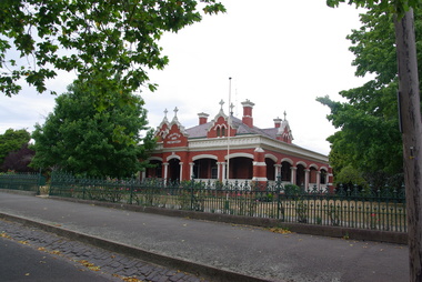
Photograph - Colour, Clare Gervasoni, St Alipius Presbytery, Ballarat East, 07/01/2012
St Alipius Church was the first Catholic Church at Ballarat. It was initially a tent church in Humffray Street, but after flooding it was moved to Victoria Street were the current bluestone church was built. The presbytery is beside the church and houses the priests. A colour photograph in digital format showing red brick building with slate roof, behind a green iron fence. The building is St Alipius Presbytery, Victoria Street, Ballarat East. ballarat east, catholic, religion, church, st alipius', st alipius -
 Victorian Interpretive Projects Inc.
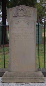
Photograph - Colour, Clare Gervasoni, Headstone of the grave of William Henry Bacchus, 14/01/2012
Captain William Bacchus was an early settler in the area now known as Bacchus Marsh. Bacchus died in 1849 aged 67. The town of Bacchus Marsh is named after him.Colour photograph in digital format of a grave in a grassy landscape. It is the headstone of early settler William Henry Bacchus in the grounds of the Holy Trinity Anglican Church, Bacchus Marsh. bacchus marsh, william bacchus, holy trinity, churchyard, cemetery -
 Victorian Interpretive Projects Inc.
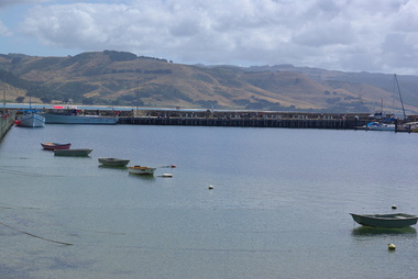
Photograph - Colour, Clare Gervasoni, Apollo Bay Marina, 2013, 27/01/2013
The image show the number and typs of boats moored at Apollo Bay Marina in late January 2013.Two colour photgraphs showing the marina at Apollo Bay from the pier. .1) a number of anchored boats .2) a number of fishing vessells at the marina. apollo bay, boat, vessel, fishing -
 Victorian Interpretive Projects Inc.
Photograph - Colour, Clare Gervasoni, Ebenezer Mission, 2013, 01/06.2013
A selection of images of Ebenezer Aboriginal Mission. -
 Victorian Interpretive Projects Inc.
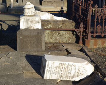
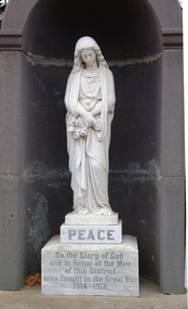
Photograph - Colour, Clare Gervasoni, Gravestone of Clarence M. Cox in the Ballaarat Old Cemetery, 2014, 01/2014
Clarence M. Cox fell at Bullecourt, France, on 11 April 1917. See https://bih.federation.edu.au/index.php/Clarence_M._Cox Broken marble headstone in the Ballaarat Old Cemetery. It is a memorial for Corporal Clarence M. Cox who served during World War One as a Corporal. ballaarat old cemetery, gravestone, headstone, cemetery, cox, clarence cox, world war one, bullecourt -
 Victorian Interpretive Projects Inc.
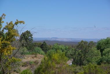
Photograph - Colour, Clare Gervasoni, Mount Franklin From Maldon, 2013, 09/01/2013
Mount Franklin was named after John Franklin.A digital colour photograph showing the extinct volcano known as Mount Franklin in the distance. The photo was taken from the site of the former Beehive Mine in Maldon.mount franklin, maldon, volcano, beehive, beehive mine -
 Victorian Interpretive Projects Inc.
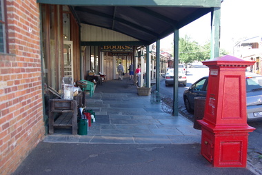
Photograph - Colour, Clare Gervasoni, Maldon, 2013, 09/01/2013
Three colour digital images showing the main street of Maldon. They images include flagstones and stone guttersmaldon, flagstone, gutter, spoon gutter, verandah -
 Victorian Interpretive Projects Inc.
Photograph - Colour, Clare Gervasoni, Snake Valley War Memorial, 2013, 01/04/2013
world war 1, world war, snake valley, war memorial -
 Victorian Interpretive Projects Inc.
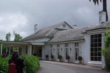
Photograph - Colour, Chateau Yering, 2014, 01/01.2014
Chateau Yering at Yarra Glenyering, chataeu yering, yarra glen -
 Victorian Interpretive Projects Inc.
Photograph - Colour, Clare Gervasoni, Yering Station, 2014, 01/1102014
Yering Station which was first settled by Paul De Castella of Neuchatel, Switzerland. De Castella was a pioneer of Australia's wine industry. The brick building was constructed of handmade bricks around 1859 by Paul De Castella to process grapes grown at Yering Station. De Castella used advanced winemaking equipment imported from Bordeaux, France. Yering Station wines were successful at the World Exhibition in Paris (1889) when it received the only 'Grand Prix' in the Southern Hemisphere. yering, wine, winery, de castella, paul de castella, yering station, neauchatel -
 Victorian Interpretive Projects Inc.
Photograph - colour, Clare Gervasoni, House with shingle roof in Lydiard (North) Street, Ballarat, 2014, 18/01/2015
Although this house has been clad and had an iron roof put onto it, the historical integrity still appears to be intact. Colour photograph of a clad weatherboard house in Lydiard (North) Street Ballarat. Some of the iron roofing has been removed exposing shingles.weatherboard, shingles, lydiard street, house -
 Victorian Interpretive Projects Inc.
Photograph-Colour, Wild Dog Creek, Apollo Bay, 2015, 25/01/2015
Wild Dog Creek enters the sea at Apollo BayA number of colour photographs showing the mouth of Wild Dog Creek as it enters the sea at Apollo Bal, Victoria.apollo bay, sea, creek, river mouth, wold dog creek -
 Victorian Interpretive Projects Inc.
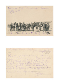
Photograph - digital, Australian Soldiers at Sinai, Egypt, 26/01/2015
A group of Australian soldiers in Egypt during World war one. The card was written on by Trooper William West. Front: Taken at Hat Armusca Sinai Egypt Verso: (Illegible) Sinai Egypt, January 26, 1917 The nine members of our mess. Reading from left to right. 1. Cpl G. McDonald. 2. Trooper J. Ayre 3. Trooper A. Allanson. 4. Trooper W. West. 5. Trooper B. Thorpe 6. Trooper A. Dawson. 7. Trooper R. Wilson. 7. Trooper N. W. Calmon. 8. Trooper Reg Cuttinson. Taken at Hat Arnusca. Billiewilliam west, world war, world war one, egypt, sinai, troopers, horses, mcdonald, allanson, west, thorpe, dawson, wilson, calman, cullinan, mmm -
 Victorian Interpretive Projects Inc.
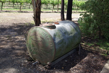
Photograph - colour, Clare Gervasoni, Furphy Water Cart, 2014, 01/11/2014
The water cart was in itself a complete invention of John Furphy and was first made in the 1880's. At the time no similar article was used in Australia. Few houses of the time were designed to collect rain water from the roof and hence, water needed to be collected elsewhere and transported for stock and domestic use. The method of carting water was then confined to horse drawn drays or sleds with mounted wooden barrels or casks. At the same time the growing demand for agricultural implements, led to the establishment of a foundry with a furnace to cast components rather than the time consuming task of forging. This became the catalyst for the efficient production of the robust and mobile water carrier known then, and now, as the Furphy Farm Water Cart.Four colour photographs showing a tank made by Furphy and Sons, Shepparton.furphy, shepparton, water storage -
 Victorian Interpretive Projects Inc.
Photograph - Colour, Former Beechworth Gaol, 2011, 01/09/201
Colour photographs of the former Beechworth Gaol. -
 Bay Steamers Maritime Museum
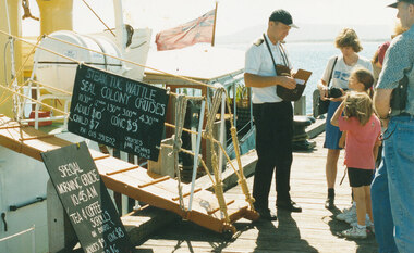
Photograph, Steam Tug Wattle at Rye Pier, c. 01/2000
One of a series of photographs taken by Michael Ritchie who was enthusiastic deck hand on Wattle. Photographs taken when Wattle was at Rye for the Christmas/New Year period, most likely 1997. Sailing schedule,shows 5 cruises per day, ticket prices, cruise destination of Seal Colony.and tea, coffee & scrolls available. Colour photograph of Wattle moored at Rye Pier, looking to stern. Gangway, lifeboat, signs, Red Ensign visible. Skipper Leigh Doeg selling tickets to 2 parents,2 children on right hand side of photographsteam tug wattle, rye pier, seal colony cruises, leigh doeg, michael ritchie