Showing 2090 items
matching bendigo maps
-
 Bendigo Historical Society Inc.
Map - HUNTLY, SHEET 4, 29/03/1876
... Inc. History House 11 Mackenzie Street Bendigo goldfields MAP ...Map: Parish of Huntly, Sheet 4, County of Bendigo. Hand Draughted Parish plan. Originally in Map Cupboard. Relocated to Map Drawer 5 on 22.9.22. Too long for the map cupboard.map, bendigo, parish plan, huntly -
Bendigo Historical Society Inc.
Map - NEILBOROUGH, 6/12/1882
... Inc. History House 11 Mackenzie Street Bendigo goldfields MAP ...Map: Parish of Neilborough, County of Bendigo. Parish plan. Earliest date on map 21/8/1877.map, bendigo, parish plan, neilborough -
Bendigo Historical Society Inc.
Map - NEILBOROUGH, 21/01/1875
... Inc. History House 11 Mackenzie Street Bendigo goldfields MAP ...Map: Parish of Neilborough, County of Bendigo. Hand Draughted Parish plan. Map dated 21/1/1875.map, bendigo, parish plan, neilborough -
Bendigo Historical Society Inc.
Map - EGERTON, 28/01/1896
... Inc. History House 11 Mackenzie Street Bendigo goldfields MAP ...Map: Parish of Egerton, County of Bendigo. Parish plan. (number 335 in map cupboard 1)map, bendigo, parish plan, egerton -
Bendigo Historical Society Inc.
Map - CALAVIL, 28/08/1874
... Inc. History House 11 Mackenzie Street Bendigo goldfields MAP ...Map: Country Lands, Parish of Calavil, County of Bendigo. Parish plan (number 334 in map cupboard 1)map, bendigo, country lands, country lands, parish of calavil -
Bendigo Historical Society Inc.
Map - BALLENDELLA, 12/06/1882
... Inc. History House 11 Mackenzie Street Bendigo goldfields MAP ...Map: Parish of Ballendella, County of Bendigo. Parish plan (number 333 in map cupboard 1)map, bendigo, parish plan, ballendella -
Bendigo Historical Society Inc.
Map - GRAZING ALLOTMENTS, 15/10/1894
... Inc. History House 11 Mackenzie Street Bendigo goldfields MAP ...Map: Grazing Allotments, Parishes of Whirrakee and Bagshot, County of Bendigo. Parish plan (number 331 in map cupboard 1)map, bendigo, grazing allotments, grazing allotments, whirrakee, bagshot -
Bendigo Historical Society Inc.
Map - AVAILABLE ALLOTMENTS, 10/08/1908
... Inc. History House 11 Mackenzie Street Bendigo goldfields MAP ...map: Available Allotments, Parishes of Whirrakee, Bagshot and Egerton, County of Bendigo. Parish plan (coloured) (number 330 in map cupboard 1)map, bendigo, allotments, available allotments, whirrakee, bagshot, egerton -
Bendigo Historical Society Inc.
Map - BAGSHOT, Circa 1878
... Inc. History House 11 Mackenzie Street Bendigo goldfields MAP ...Map: Parish of Bagshot, County of Bendigo. Parish plan (coloured) (number 329 in map cupboard 1)map, bendigo, parish plan, bagshot -
Bendigo Historical Society Inc.
Map - MARONG, 16/08/1881
... Inc. History House 11 Mackenzie Street Bendigo goldfields MAP ...Map: Parish of Marong, County of Bendigo. Parish plan (number 328 in map cupboard 1)map, bendigo, parish plan, marong -
Bendigo Historical Society Inc.
Map - EPPALOCK, 3/11/1882
... Inc. History House 11 Mackenzie Street Bendigo goldfields MAP ...Map: Parish of Eppalock, County of Bendigo. Parish plan (number 327 in map cupboard 1)map, bendigo, parish plan, eppalock -
Bendigo Historical Society Inc.
Map - GOORNONG, 29/04/1879
... Inc. History House 11 Mackenzie Street Bendigo goldfields MAP ...Map: Parish of Goornong, County of Bendigo. Parish plan (coloured) (number 326 in map cupboard 1)map, bendigo, parish plan, goornong -
Bendigo Historical Society Inc.
Map - FARADAY, 10/01/1879
... Inc. History House 11 Mackenzie Street Bendigo goldfields MAP ...Map: Parish of Faraday, County of Talbot. Parish plan. Earliest date on map December 1877.map, talbot, parish plan, faraday -
Bendigo Historical Society Inc.
Map - DARGILE, 14/10/1906
... Inc. History House 11 Mackenzie Street Bendigo goldfields MAP ...Map: Parish of Dargile, County of Rodney. Parish plan (number 324 in map cupboard 1)map, rodney, parish plan, dargile -
Bendigo Historical Society Inc.
Map - LEICHARDT, 23/05/1875
... Inc. History House 11 Mackenzie Street Bendigo goldfields MAP ...Map: Parish of Leichardt, County of Bendigo. Parish plan (coloured). Attached plan in the top left hand corner marked 'Building Lots' (number 323 in map cupboard 1)map, bendigo, building lots, leichardt -
Bendigo Historical Society Inc.
Map - TOWNSHIP OF LOCKINGTON, 21/09/1915
... Inc. History House 11 Mackenzie Street Bendigo goldfields MAP ...Map: Township of Lockington, Parish of Bamawm, County of Bendigo. Parish plan.Has a clipping from 'The Riverine Herald' dated 20/11/1915 on the reverse side re. the sale of blocks in Bamawm Township (number 322 in map cupboard 1)map, bendigo, township, lockington, bamawm, the riverine herald -
Bendigo Historical Society Inc.
Map - WELLSFORD, 15/10/1903
... Inc. History House 11 Mackenzie Street Bendigo goldfields MAP ...Map: Parish of Wellsford, County of Bendigo. Parish plan (number 321 in map cupboard 1)map, bendigo, parish plan, wellsford -
Bendigo Historical Society Inc.
Map - HEATHCOTE, 11/04/1935
... Inc. History House 11 Mackenzie Street Bendigo goldfields MAP ...Map: Parish of Heathcote, County of Dalhousie. Parish plan (number 320 in map cupboard 1)map, dalhousie, parish plan, heathcote -
 Bendigo Historical Society Inc.
Map - SANDHURST SHEET 3, June 29th 1967
... Inc. History House 11 Mackenzie Street Bendigo goldfields MAP ...Map: Sandhurst sheet 3. Parish plan.map, bendigo, city streets, sandhurst, early bendigo -
 Bendigo Historical Society Inc.
Map - SANDHURST SHEET 2, March 12th 1867
... Inc. History House 11 Mackenzie Street Bendigo goldfields MAP ...Map: Sandhurst sheet 2 . Parish plan.map, bendigo, city streets, sandhurst, early bendigo -
 Bendigo Historical Society Inc.
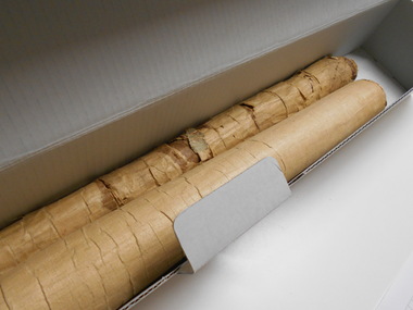
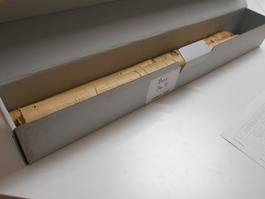
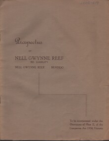
Document - MCCOLL, RANKIN AND STANISTREET COLLECTION: NELL GWYNNE REEF N/L - PROSPECTUS, 1938
Document. Slim, stapled Greybrown book. Nell Gwynne Reef N/L Prospectus. Contains underground maps.McColl, Rankin & Stanistreetorganization, business, nell gwynne reef mine, mccoll, rankin & stanistreet, nell gwynne reef n/l, gold mining, prospectus -
Bendigo Historical Society Inc.
Map - COUNTY OF GLADSTONE, November 1910
... Inc. History House 11 Mackenzie Street Bendigo goldfields MAP ...Map: County of Gladstone, Geological survey of Victoria. Geological mapmap, gladstone, geological, county of gladstone, geological map -
Bendigo Historical Society Inc.
Map - PLAN OF THE BENDIGO RAILWAY YARD, Circa 1960
... Map: Plan of the Bendigo Railway Yards, Scale: 80 feet to 1... Inc. History House 11 Mackenzie Street Bendigo goldfields MAP ...Map: Plan of the Bendigo Railway Yards, Scale: 80 feet to 1 inch. 1960's. (number 319 in map cupboard 1) Location unknown. Image in Mosaic images overflow.map, bendigo, railway yard, railways, rail yards, station layout -
Bendigo Historical Society Inc.
Map - SHEEPSHEAD LINE OF REEF, Circa 1940's
... Inc. History House 11 Mackenzie Street Bendigo goldfields MAP ...Map: Plan showing a Longitudinal section of the Sheepshead line of Reefs , Bendigo. (34 Copies)map, bendigo, mining plan, sheepshead line of reef, gold mines , mining -
Bendigo Historical Society Inc.
Map - RED WHITE AND BLUE EXTENDED MINE, 5/12/1940
... Inc. History House 11 Mackenzie Street Bendigo goldfields MAP ...Map: Transverse section of The Red , White and Blue Extended Mine, Sheepshead line of Reef, Bendigo. (37 Copies). By J.J. Caldwell, District Field Geologist, Mines Department Bendigo.map, bendigo, mining plan, red white and blue extended mine, sheepshead line of reef, mining , gold mines -
Bendigo Historical Society Inc.
Map - PART OF ELLESMERE, 20/06/1875
... Inc. History House 11 Mackenzie Street Bendigo goldfields MAP ...Map: Re-survey of part of the Parish of Ellesmere, hand draughted Parish plan Reloacated to Map Drawer 5 on 22.9.2022. Hanging strip detached.map, bendigo, parish plan, ellesmere -
Bendigo Historical Society Inc.
Map - TALAMBE, 26/11/1880
... Inc. History House 11 Mackenzie Street Bendigo goldfields MAP ...Map: Parish of Talambe, County of Bendigo. Parish plan (number 315 in map cupboard 1)map, bendigo, parish plan, talambe -
Bendigo Historical Society Inc.
Map - PANNOOBAMAWM, 6/11/1882
... Inc. History House 11 Mackenzie Street Bendigo goldfields MAP ...Map: Parish of Pannoobamawm, County of Bendigo, Parish plan (number 314 in map cupboard 1)map, bendigo, parish plan, pannoobamawm -
Bendigo Historical Society Inc.
Map - PANNOOBAMAWM, 7/12/1914
... Inc. History House 11 Mackenzie Street Bendigo goldfields MAP ...Map: Parish of Pannoobamawm, County of Bendigo. Parish plan (number 313 in map cupboard 1)map, bendigo, parish plan, pannoobamawm -
Bendigo Historical Society Inc.
Map - SEDGWICK, 5/04/1881
... Inc. History House 11 Mackenzie Street Bendigo goldfields MAP ...Map: Parish of Sedgwick, County of Bendigo. Parish plan (number 312 in map cupboard 1)map, bendigo, parish plan, sedgwick