Showing 179546 items
matching melbourne-map
-
 Moorabbin Air Museum
Map (Item) - Includes details of BHP properties, Newcastle Australia map
-
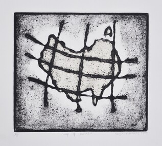
Federation University Art Collection
Printmaking - Collograph, Fusea, Janine, The Map is in the Brain
This item is part of the Federation University Art Collection. The Art Collection features over 1000 works and was listed as a 'Ballarat Treasure' in 2007.art, artwork -
University of Melbourne, Burnley Campus Archives
Plan, V.C.A.H Burnley Location map, c.1991
Plan of the Campus with buildings named.vcah, burnley campus -
University of Melbourne, Burnley Campus Archives
Plan, Classroom Locations Map, 1990-2000
Plan produced by VCAH Burnley with classrooms marked.vcah, burnley -
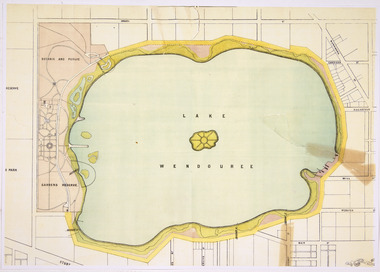 Friends of Ballarat Botanical Gardens History Group
Map - Lake Wendouree Map
Colour photocopy showing some tears in original lake wendouree, ballarat city council -
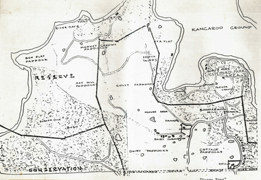 Wonga Park Community Cottage History Group
Plan (sub-item) - Black and White, Map of “Yarra Brae”, site of Scout Jamboree and World Rover Moot
-
Friends of St Brigids Association
The Irish Australians : selected articles for Australian and Irish family historians, The Irish Australians : selected articles for Australian and Irish family historians / edited by Richard Reid and Keith Johnson .1984. Sydney : Society of Australian Genealogists, 1984 56 p. : ill., facsims., map, ports. ; 30 cm
-
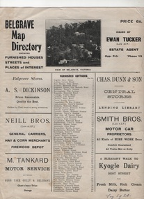 Sherbrooke Foothills Historical Society
Work on paper - Belgrave Map Directory 1920s
-
Camberwell Historical Society
Pamphlet (Item) - Map, Boroondara City of Harmony, Boroondara Leisure and Recreational Map, 1998
boroondara -
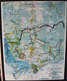
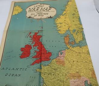 Ringwood RSL Sub-Branch
Work on paper - Map theaters of war, latest war map, Printed map
-
 Ringwood RSL Sub-Branch
Map - Vietnam map, 1969-1972 map Vietnam on hard backing
-
 Merri-bek City Council
Work on paper - Collograph on Chine colle, George Matoulas, Map of Australia, 2009
-
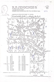 Ringwood and District Historical Society
Document, Land Sale Map and Price List - Pinewood Rise Subdivision, Ringwood, Victoria - (Undated, circa 1988)
Single page black & white photocopy of subdivision plan showing layout of 28 residential allotments with inset showing price list & some marked 'sold'.Director and Licensed Estate Agent - R.F. Jennings Pty Ltd., 8 Streeton Lane, Doncaster East 3109. Phone 842 7666 all hours. -
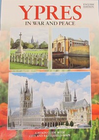 Warrnambool RSL Sub Branch
Book, BOOK: YPRES in War and Peace - A Pitkin guide with city and battlefield map
-
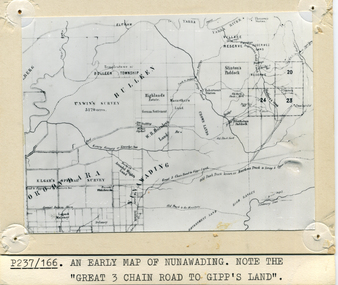 Whitehorse Historical Society Inc.
Photograph - B/W Photograph, Map of Nunawading
Black and white photo of early sub-division of Nunawading.|NOTE:- Great 3 Chain Road to Gipp's Land.nunawading, map -
Merbein District Historical Society
Document, Merbein Cemetery Location map, unknown
merbein township, cemetery -
Merbein District Historical Society
Map, Mildura and District Map, After 1954
merbein, yelta, merbein south, the lake, merbein west, birdwoodton -
Merbein District Historical Society
Map, Whitehead's Map of Victoria with Alphabetical Key, 1869
merbein -
Merbein District Historical Society
Document, Map Of Victoria (Fishers), unknown
advertisements -
University of Melbourne, Burnley Campus Archives
Map, Map of Showgrounds, c. 1970
Tracing paper plan with grid lines. Student project? -
University of Melbourne, Burnley Campus Archives
Plan, VCAH Burnley College Swan Street Richmond - Classroom Locations Map, c.1991
2 copies of plan dated c1991. Buildings named, classrooms numbered.vcah, burnley, classrooms -
Clunes Museum
Plaque - PRINTING PLATE, Stoney Creek School, map of Australia made by students with stones
METAL PRINTING PLATE WITH IMAGE OF THE SITE OF STONEY CREEK SCHOOLlocal history, documents, newpaper, publishing, schools, stoney creek -
 Melbourne Tram Museum
Map, Yarra Trams, "Grand Prix Map", 1996
Laminated sheet - to fit into a pocket - prepared by Greg Rodgers for Camberwell Depot drivers using Park St Kilda Grand Prix services - give details of automatic points, safety notes, details of St Kilda Road points, and what Camberwell drivers are to do. Greg Rodgers advised 5-11-2016, made for the first Grand Prix 1996.trams, tramways, camberwell depot, grand prix, map, public transport, park st st kilda -
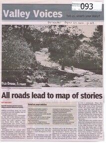 Greensborough Historical Society
Newspaper - Newspaper clipping, All roads lead to map of stories, 27/04/2011
Family history of Josiah Holloway, origins of street names in the subdivision of Eltham History of Eltham and origins of street names connected with pioneers of the area.Newsprint, gray scale. Photograph of Keylock's Bridge on Diamond Creek at ElthamDV Leader April27 2011, p23josiah holloway, jack shallard, susanna maria bible, bradbury, henry brougham, handfield, fay harcourt, violet bank, kangaroo ground, bells hillroad, shalbury avenue, beard street, brougham street, main road, eltham -
Whitehorse Historical Society Inc.
Map - WW1 Trench map, Belgium collected by C H Honybun, Belgium WW1 map, Aug 1917
WW1 map of Belgium Edition 1. Sheet 28 S.W. and S.E. with trenches in red around the towns of Comines and Warnetonnon-fictionWW1 map of Belgium Edition 1. Sheet 28 S.W. and S.E. with trenches in red around the towns of Comines and Warnetonworld war 1914 - 1918, maps -
Whitehorse Historical Society Inc.
Map - WW1 Trench map, Belgium collected by C H Honybun, Belgium WW1 map Edition 3, Nov 1917
WW1 map of Belgium Edition 3 Sheet 28 S.W. and S.E. Trenches in rednon-fictionWW1 map of Belgium Edition 3 Sheet 28 S.W. and S.E. Trenches in redworld war 1914 - 1918, maps -
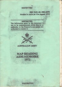 National Vietnam Veterans Museum (NVVM)
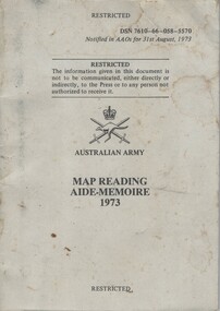
Booklet, Australian Army, Australian Army: Map Reading Aide-Memoire, 1973 (Copy 1), 1973
A green coloured cardboad cover with black information on the front. Near the top right hand corner reads DSN 7610-66-058-5570. Above the Australian Army insigni is the paragraph on the Restricted text and under the insignia are the details of the booklet. the booklet is held together with two metal staples and is covered with a plastic cover.booklet, australian army, map reading, aide-memoire -
 National Vietnam Veterans Museum (NVVM)
Booklet, Australian Army, Australian Army: Map Reading Aide-Memoire, 1973 (Copy 2), 1973
A green coloured cardboad cover with black information on the front. Near the top right hand corner reads DSN 7610-66-058-5570. Above the Australian Army insigni is the paragraph on the Restricted text and under the insignia are the details of the booklet. the booklet is held together with two metal staples and is covered with a plastic cover.booklet, australian army, map reading, aide-memoire -
 Ringwood and District Historical Society
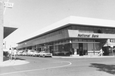
Photograph, National Bank Building, Melbourne Street, Ringwood 1973
Black and white photograph of National Bank building on corner Melbourne St and Civic Pl Ringwood.On Reverse: "3.4.73 On Site of Old Town Hall" 3rd April 1973 -
Port Melbourne Historical & Preservation Society
Banner, Port Melbourne
Used at a proterstors' rally on the beach beside Station Pier possibly 1988 or 89White cotton banner, orange "Port Melbourne" lettering. Grey shipping motif images as backgroundarts and entertainment, port melbourne, janet bolitho