Showing 3220 items
matching road map
-
 Whitehorse Historical Society Inc.
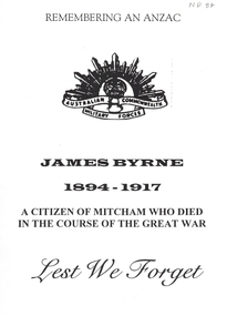
Document, Remembering an Anzac, 1/06/1997 12:00:00 AM
A Luther Collage Year 10 History essay which documents a visit to several war memorials and researches the history of James Byrne, a name on the Mitcham War Memorial. He had enlisted in 1915 and had been discharged dur to epilepsy. He reinlisted in 1916 and was sent to England where he died in camp. The reason given wassuffocation due to the influence of drink. The author surmises it may have been an epileptic fit. Maps & photographs included.byrne, james, ww1, war memorials -
 Whitehorse Historical Society Inc.
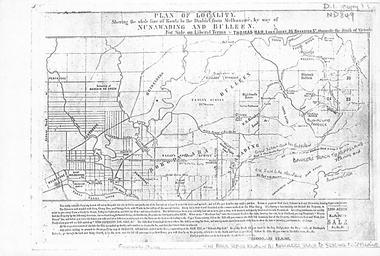
Map, Plan of locality, 1855-60?
'Plan of locality, showing the whole line of route to the district from Melbourne by way of Nunawading and Bulleen. 2,000 acres for sale... Thomas Ham, Land Agent [ 1855 - 60?]nunawading, bulleen, barkers track, land sales -
 Whitehorse Historical Society Inc.
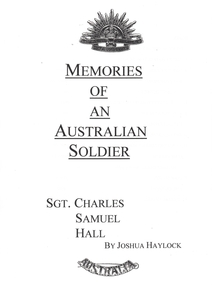
Photograph - School Project, Memories of an Australian Soldier, 1/06/1997 12:00:00 AM
Photocopy of Luther College Year 10 history project describing several war memorials and researching the story of Sergeant Charles Samuel Hall whose name appears on the Mitcham War Memorial. He served at Gallipoli and on the Western Front but contracted tuberculosis and died at the Australian Military Hospital, Harefield Park in Middlesex. The report includes information about tuberculosis and relates the disease to the conditions in Gallipoli and in France. A report on the Battle of Pozieres is included. 70p. Maps. Photographs.hall, charles samuel, world war 1914-1918. battle of poziers, war memorials -
 Whitehorse Historical Society Inc.
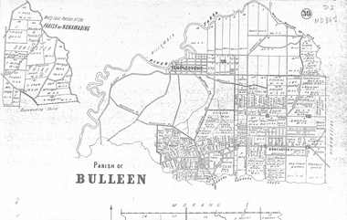
map, Parish of Bulleen, Not dated
A map on the parish of Bulleen.Parish of Bulleen with North East portion of the Parish of Nunawading [n.d. 1890's?]A map on the parish of Bulleen.shire of bulleen, shire of nunawading, land settlement -
 Whitehorse Historical Society Inc.
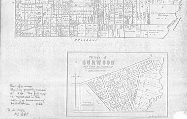
document - Map, Village of Burwood, 1892
Map on the village of Burwood.Village of Burwood : old name Ballyshanassy (with southern section of Nunawading). Area bounded by Chapman, Ireland and Evans Streets). Victorian Shire Map. co. 26 November 1892. Scale: 8 chains = 1 inch. The full map is reproduced in 'The History of Nunawading' by Niall Brennan, p. 62.Map on the village of Burwood.burwood, land settlement -
 Whitehorse Historical Society Inc.
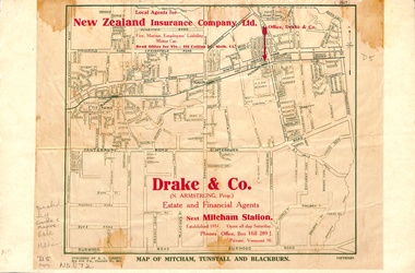
Map, Map of Mitcham, Tunstall and Blackburn, 1920 ?
Map of Mitcham, Tunstall and Blackburn.Map of Mitcham., Tunstall and Blackburn. Overprinted 'Drake & Co.' 1 copy 1927?, 1 copy 193-?Map of Mitcham, Tunstall and Blackburn.mitcham, tunstall, nunawading, blackburn, maps, drake & co., forest hill, vermont -
 Whitehorse Historical Society Inc.
Map, Mitcham Riding, n.d
... Whitehorse Historical Society Inc. 2-10 Deep Creek Road ...Shire of Nunawading: Mitcham Riding [n.d.] (between Springvale and Mitcham Roads) (Shows electric light mains. MMBW reserves, railway line.)mitcham, maps, tunstall, forest hill -
Whitehorse Historical Society Inc.
Map, Mitcham Riding, n.d
... Whitehorse Historical Society Inc. 2-10 Deep Creek Road ...Shire of Nunawading: Mitcham Riding [n.d.] between Mitcham and Heatherdale Roads) (Shows electric light mains, MMBW reserves and railway line.mitcham, maps, vermont -
Whitehorse Historical Society Inc.
Map, Nunawading, Ringwood and Scoresby, 16/02/1858 (original)
Plan of country lands in the Parishes of Nunawading, Ringwood and Scoresby in the Counties of Bourke and Mornington. Lithographed at the Public Lands Office, Melbourne, 16 February 1858. Inset: Pound Reserve, Nunawading.nunawading, ringwood, scoresby, maps -
 Whitehorse Historical Society Inc.
Map - Nunawading scaled Map, Nunawading, 1864
Parish plan of Nunawading, Lands Department, 1864, showing names of first purchasers of land. Copy also at NP215.parish of nunawading, land settlement, maps -
Whitehorse Historical Society Inc.
Map, Township of Norwich, ca 1850
Plan of the Township of Norwich being subdivision of Section III, Parish of Nunawading, County of Bourke, consisting of suburban farms, vineyard sites and town lots, for sale by auction by W. Casey & Co. [c. 1850]. Original in Vale Maps Collection, La Trobe Library.norwich village, vermont, parish of nunawading, vermont south, maps -
![Parish of Nunawading, County of Bourke showing land acquired under Closer Settlement Acts [C 1887]](/media/collectors/56f368632162f118acbff12e/items/60d923316e5f99545134f182/item-media/6147b12a4806c7ae686c24e4/item-fit-380x285.jpg) Whitehorse Historical Society Inc.
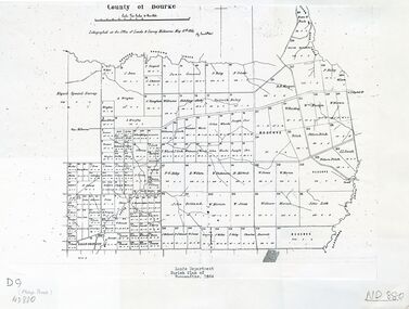
Whitehorse Historical Society Inc.Map, Parish of Nunawading, ca 1887
Parish of Nunawading, County of Bourke showing land acquired under Closer Settlement Acts [C 1887]Parish of Nunawading, County of Bourke showing land acquired under Closer Settlement Acts [C 1887] 1947 reprint.Parish of Nunawading, County of Bourke showing land acquired under Closer Settlement Acts [C 1887] parish of nunawading, box hill, maps, land settlement -
Whitehorse Historical Society Inc.
Map, Parish of Nunawading, 1970
[Parish of] Nunawading, County of Bourke. Government Printer Showing original land owners.parish of nunawading, maps, land settlement -
 Whitehorse Historical Society Inc.
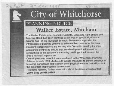
Document - Article, Planning Notice, 21/12/1998 12:00:00 AM
... Mitcham melbourne Maps Walker Estate Mitcham Road Mitcham Calcutta ...Planning Notice concerning the Walker Estate in Mitcham. Amendment to the Whitehorse Planning Scheme could include protection of buildings of historical significance, proposed early in 1999. Includes map of area.maps, walker estate, mitcham road, mitcham, calcutta street, mitcham, delhi street, mitcham, agra street, mitcham, simla street, mitcham, benares street, mitcham, meerut street, mitcham, the strand, mitcham, percy street, mitcham, stanley grove, mitcham, bray, dawn -
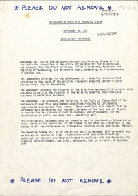 Whitehorse Historical Society Inc.
Legal record - Document, Melbourne Metropolitan Planning Scheme, 1987
Explanatory Statement of Amendment 500 to Melbourne Metropolitan Planning Scheme, including map of area (South of Blackburn Station). To be exhibited from 2 October 1987 to 22 December 1987.roads and streets, victoria. ministry for planning and environment, city of nunawading, south parade, blackburn, blackburn road, blackburn, main street, blackburn -
Whitehorse Historical Society Inc.
Document, City of Nunawading Community Facilities, 1/06/1982 12:00:00 AM
Map of community facilities in the City of Nunawading 1982Map of community facilities in the City of Nunawading 1982 produced by the Burwood History Group. Scale: 3 1/2cm = 1 km.Map of community facilities in the City of Nunawading 1982burwood historical group, city of nunawading, maps -
 Whitehorse Historical Society Inc.
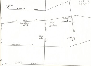
Map, Potteries, n.d
Sketch map of location of potteries in the area bounded by Middleborough, Springfield, Mitcham Roads and Burwood Highway.Sketch map of location of potteries in the area bounded by Middleborough, Springfield, Mitcham Roads and Burwood Highway.Sketch map of location of potteries in the area bounded by Middleborough, Springfield, Mitcham Roads and Burwood Highway.potteries, vitclay pipes pty ltd, blackburn brick and tile co., geal bros., wunderlich limited, australian tesselated tile co. pty ltd., daniel robertson australia pty ltd -
 Whitehorse Historical Society Inc.
Article, Burwood Link Pedestrian Bridge, 2018
Sketch map of location of potteries in the area bounded by Middleborough, Springfield, Mitcham Roads and Burwood Highway.Photograph of the Burwood Link Pedestrian Bridge at Gardiners Creek Reserve provided by Whitehorse Leader reader Aisling Keogh.Sketch map of location of potteries in the area bounded by Middleborough, Springfield, Mitcham Roads and Burwood Highway.deakin university burwood campus, burwood link pedestrian bridge, gardiners creek reserve -
Whitehorse Historical Society Inc.
Document, Map of Orchards, 1922
1922 Map of orchards in the City of Nunawading, coloured green. This is a magnified localised view of ND66orchardists, orchards, blackburn, mitcham, tunstall, vermont, east burwood, tally ho -
 Whitehorse Historical Society Inc.
Document, Heritage Family Day 2018, 2018
Heritage Family Day 2018 'A Walk in the Park' leaflet, map and Royalauto advertisement.Heritage Family Day 2018 'A Walk in the Park' leaflet, map and Royalauto advertisement.Heritage Family Day 2018 'A Walk in the Park' leaflet, map and Royalauto advertisement.heritage family day 2018, city of whitehorse, schwerkolt cottage & museum complex -
Whitehorse Historical Society Inc.
Pamphlet - Periodical, North East Link, 2018
Map and information regarding the proposed North East Link Project.Map and information regarding the proposed North East Link Project produced by the North East Link Authority. See Series Contents Box for holdings.Map and information regarding the proposed North East Link Project. north east link, map -
 Whitehorse Historical Society Inc.
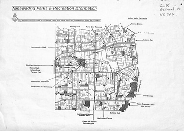
Map, Nunawading parks and recreation information, 1990 ?
Map of parks and reserves in the City of Nunawading, 199-?city of nunawading. parks and recreation department, parks and reserves -
 Whitehorse Historical Society Inc.
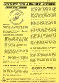
Pamphlet, Bellbird Dell - Vermont, n.d
Bellbird Dell - Vermont, leaflet produced by City of Nunawading, Parks and Recreation Department. Includes details and map.bellbird dell, parks and reserves -
 Whitehorse Historical Society Inc.
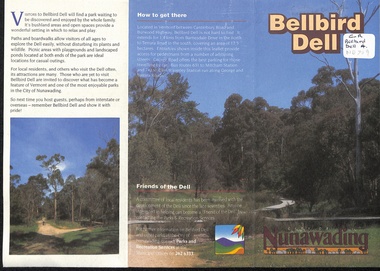
Pamphlet, Bellbird Dell, n.d
History and development of Bellbird Dell. Includes colour photos and map.parks and reserves, city of nunawading, morack road, vermont south, george road, philip street, vermont, bellbird dell -
 Whitehorse Historical Society Inc.
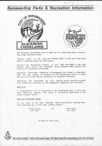
Pamphlet, Blackburn Creeklands, n.d
Blackburn Creeklands [ Information brochure with map]furness park, kalang park, blacks walk, parks and reserves -
![Halliday Park, Mitcham [brochure including map].](/media/collectors/56f368632162f118acbff12e/items/60d923316e5f99545134f11e/item-media/638068cada0955f0fff3cb27/item-fit-380x285.jpg) Whitehorse Historical Society Inc.
Whitehorse Historical Society Inc.Booklet - Pamphlet, Halliday Park, 1980 ?
Halliday Park, Mitcham [brochure including map]. City of Nunawading, Parks and Recreation, 198-?parks and reserves, halliday park -
 Whitehorse Historical Society Inc.
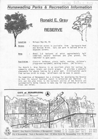
Map, Ronald E. Gray Reserve, n.d
Strategy of Committee of Management for development of reserve including planting of native trees and shrubs.parks and reserves, outlook drive, nunawading, springvale road, ashwood drive, olwen street, tatman, r. r, louden, j. b., gray, ronald e, r. e. gray reserve -
 Whitehorse Historical Society Inc.
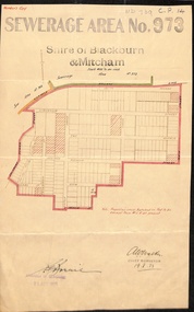
Document, Sewerage Area, 19/08/1933
Map dated 19 - 8 1933 showing sewerage area no. 973 in the Shire of Blackburn and Mitcham. Note that View Street on the plan is now Linum Street.sewerage and sanitation, shire of blackburn and mitcham, acacia avenue, blackburn, salisbury avenue, laburnum street, view street, derby street, myrtle grove, south parade, the avenue, main street, laurel grove, pakenham street, blackburn., linum street -
 Whitehorse Historical Society Inc.
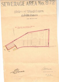
Document, Sewerage area, 13/07/1933 12:00:00 AM
Plan of sewerage area no. 972, Shire of Blackburn and Mitcham, scale 400' to an inch. 13 July 1933. Note that the area including Stuart Street on the map is now the Thiele Court area.sewerage and sanitation, shire of blackburn and mitcham, whitehorse road, blackburn, railway road, vine street, lithgow avenue, downing street, frankston street, stuart street, thiele court -
 Whitehorse Historical Society Inc.
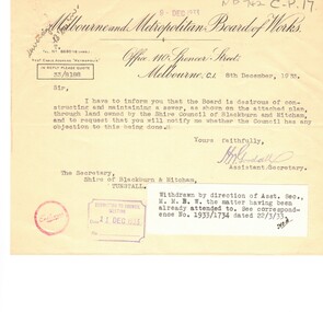
Map, Sewerage reticulation, 1933
Melbourne & Metropolitan Board of Works plan of reticulation area no 731 in the Shire of Blackburn and Mitcham 1933 and correspondence.sewerage and sanitation, melbourne and metropolitan board of works, pope road, blackburn, whitehorse road