Showing 28490 items
matching street street
-
 Bendigo Military Museum
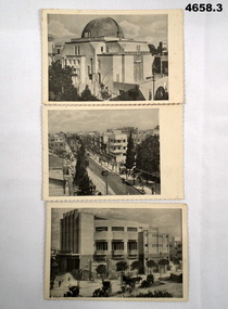
Postcard - POSTCARDS SET OF THREE OF TEL AVIV, PALESTINE, TMLINA JERUSALEM
... . A street scene of Allenby Street, Tel Aviv. 3. A scene of Moepabi... of the Shephardic Synagogue, Tel Aviv. 2. A street scene of Allenby Street ...See Cat 4575P.Set of 3 Black and white postcards printed in Palestine, WW2. 1. A scene of the Shephardic Synagogue, Tel Aviv. 2. A street scene of Allenby Street, Tel Aviv. 3. A scene of Moepabi Opera House, Tel Aviv. In the foreground can be seen horse drawn taxis.Nilww2, tel aviv, palestine -
 Warrnambool and District Historical Society Inc.
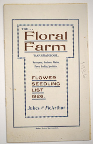
Booklet - Florist Booklet, Modern Print Warrnambool, The Floral Farm Warrnambool Flower Seedling List 1926, 1926
... township bordered by Raglan Parade, Flaxman Street and Bostock... Street (south of Merri St) Warrnambool great-ocean-road ...A business booklet of plants for sale and seasonal suggestions for planting.This booklet has sixteen pages with gold and blue printing on the white cover. The pages contain printed material. The pages have been stapled but the staples have been removed.non-fictionA business booklet of plants for sale and seasonal suggestions for planting.warrnambool plant nurseries, charles jukes -
 The Beechworth Burke Museum Research Collection
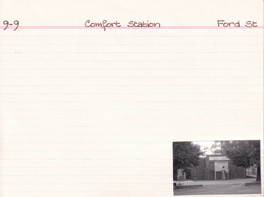
Card (Series) - Index Card, George Tibbits, Ford Street, Beechworth, 1976
... Ford Street, Beechworth...Property - Comfort Station, Ford Street Beechworth... Street Beechworth Property - Comfort Station, Ford Street ...George Tibbits, University of Melbourne. Faculty of Architecture, Building and Town & Regional PlanningIndex system that support the research for Beechworth : historical reconstruction / [by] George Tibbits ... [et al]Arranged by street names of BeechworthEach index card includes: street name and number of property, image of property, allotment and section number, property owners and dates of ownership, description of the property according to rate records, property floor plan with dimensions.beechworth, george tibbitsbeechworth, george tibbits -
 Melbourne Tram Museum
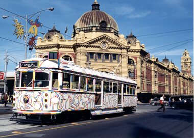
Photograph - SW5.806 at Flinders Street Station, Michael McLeod, c. 1980s
... SW5.806 at Flinders Street Station... on the route banner) on Victoria Parade, on Flinders Street...Colour Photograph - SW5.806 at Flinders Street Station... banner) on Victoria Parade, on Flinders Street with Flinders ...Photograph shows SW5 No. 806 (with "Special" indicated on the route banner) on Victoria Parade, on Flinders Street with Flinders Street Station in the background. Trolley poles are visible and in use. The tram is painted in a livery of the Transporting Art program, as a so-called "Art Tram." The artwork is by Elizabeth Gower, sponsored by Canon Australia. Photo by Michael McLeod.Shows a now-withdrawn tram with obsolete equipment (i.e., trolley poles) and livery representing a culturally important event in Melbourne's transit history.Colour Photograph - SW5.806 at Flinders Street Stationtrams, tramways, sw5 class, sw5 class tram, art trams, transporting art, public transport, tram 896 -
 Glenelg Shire Council Cultural Collection
Photograph - Sheet of 6 contact prints - Various Historic Portland buildings and landmarks, c. 1970
... Road to Bentinck Street f. Percy Street... Cliff Street Portland great-ocean-road Sheet of 6 contact prints ...Sheet of 6 contact prints of rephotographed photographs: Identifying numbers 5709 a,b,c,d,e,f Measurements a,b, c, d, e, f,5 x 3.55 x 1.5 cm a. Harbour from Post Office b. Bridge in Gardens c. Gardens Cottage d. Yankee Doodle Corner e. Cape Nelson Road to Bentinck Street f. Percy Street -
 Bendigo Historical Society Inc.
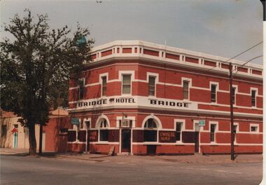
Photograph - BENDIGO HOTEL COLLECTION: BRIDGE HOTEL, BRIDGE STREET, BENDIGO
... BENDIGO HOTEL COLLECTION: BRIDGE HOTEL, BRIDGE STREET...Colour photograph: Bridge Hotel,Bridge Street, Cnr Cemetery... Inc. History House 11 Mackenzie Street Bendigo goldfields ...Colour photograph: Bridge Hotel,Bridge Street, Cnr Cemetery Street, Bendigo. Two storey red brick hotel, no verandah. White trim around windows and across top pediment. Large tree on LH side of image. Formerly called the Hibernia. Sign out front 'Chinese Meals' Hotel situated next door to Bendigo Chinese Association rooms, just visible on LH side of image.bendigo, hotel, bridge hotel -
 Bendigo Historical Society Inc.
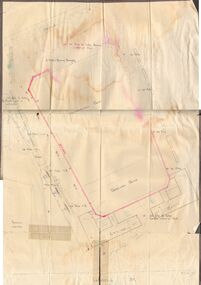
Document - BERT GRAHAM COLLECTION: PLANS FOR BENDIGO EAST, 2/12/1957
... Street Reconstruction, Lansell Street, Charleston Road. Plan... Inc. History House 11 Mackenzie Street Bendigo goldfields ...Documents, Bert Graham Collection, (a) Plan for Kennedy Street Reconstruction, Lansell Street, Charleston Road. Plan drawn by City of Bendigo, City Engineer on 18 May 1976.(b) Plan for Brick dressing pavilion at Eastern Park, Bendigo, by City of Bendigo Engineer, R. Anderson, date 2/12/1957. ( c ) Plan for Swimming Pool. Parts (a) and (b) have not been scanned because of their size.bendigo, clubs, bendigo east swimming club -
 Bendigo Historical Society Inc.
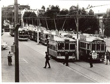
Photograph - BASIL MILLER COLLECTION: TRAMS - VIEW STREET, BENDIGO, 1960's ?
... BASIL MILLER COLLECTION: TRAMS - VIEW STREET, BENDIGO....Barnard Street...Black and white photo. Cavalcade of trams in View Street...BHS Collection basil miller Bendigo Tramways Barnard Street ...BHS CollectionBlack and white photo. Cavalcade of trams in View Street, outside Queen Elizabeth Oval, looking towards Barnard Street from Rowan Street corner. Trams are waiting for football crowd to exit QEO. Rowan Street sign on post on LH side of photo. Tram on left of photo has 'Rly station' on front. Photo, A. Doney, Bendigo stamped on back in indelible ink. Copy written in biro.A . Doney, Bendigobasil miller, bendigo tramways, barnard street, queen elizabeth oval -
 Whitehorse Historical Society Inc.
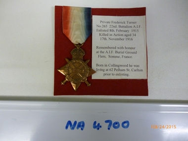
Medal, C. 1919
... McDowall Street Mitcham, cnr Harrison Street. Branch closed early... in Collingwood, he was living at 62 Pelham Street, Carlton prior... located at 26 McDowall Street Mitcham, cnr Harrison Street. Branch ...W.W.I. Star Medal awarded to Private Frederick Turner.|From the Returned Services League, Mitcham Sub - Branch located at 26 McDowall Street Mitcham, cnr Harrison Street. Branch closed early 2014.1914-15 Star Medal with attached ribbon sitting on a red felt square with information as follows:|'Private Frederick Turner; No. 265 22nd Battalion AIF Enlisted 8th February 1915; Killed in Action aged 34; 17th November 1916.|'Remembered with Honour at the A.I.F. Burial Ground, Flers, Somme, France.|'Born in Collingwood, he was living at 62 Pelham Street, Carlton prior to enlisting..as abovemilitary history, army, numismatics, medals - military -
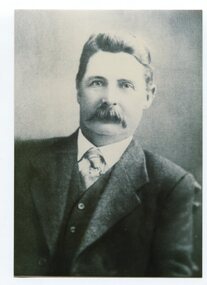 Orbost & District Historical Society
black and white photograph, 1905 - 1921
... in Nicholson Street (the main street), Orbost in the early 20th...Orbost & District Historical Society Ruskin Street Orbost ...This is a photograph of Councillor Alex Rodwell who represented Central Riding in the Orbost Shire Council. from 1905 - 1926 and from 1932 - 1937. He was president 1909-1910 and 1920-1921. A. E. Rodwell was a wholesale and retail butcher in Nicholson Street (the main street), Orbost in the early 20th century.He was involved as president of the Orbost Agricultural society.This item is associated with the Orbost Shire Council. The shire covered an area of 9,347 square kilometres and existed from 1892 until 1994 when it became part of the East Gippsland Shire Council.A black / white head and shoulders portrait photograph of a man in a suit. there is also a framed copy.rodwell-a,e, orbost-shire-council -
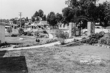 Eltham District Historical Society Inc
Photograph, Inside the garden of the War memorial with paths and entrance gates along Main Road, Eltham, February 1968, Feb 1968
... dudley street...Shows the east side shops between Arthur Street and Dudley... melbourne Shows the east side shops between Arthur Street and Dudley ...Shows the east side shops between Arthur Street and Dudley Street and former Eltham Shire Offices. View is from the entrance of the Baby Health Centre. The roadway outside the gates was not made and was used for parking. The shops and an early fire station (near to left gate post) show the area before the Woolworths rebuilding of the area to Eltham.In February 1968 an unknown person took a series of photos from the Eltham Hotel at Pitt Street heading north along Main Road through the shopping centre to just north of Elsa Court covering the length of the section of Main Road which was duplicated shortly thereafter. Shows the condition and environment of the streesscape of Main Road, Eltham immediately prior to the duplication between Pitt Street and Elsa Court through the shopping centre. Also shows a number of shops and businesses that operated at that time.Black and white photographduplication, eltham, main road, dudley street, shire of eltham war memorial, arthur street, shopping centre, eltham shire office -
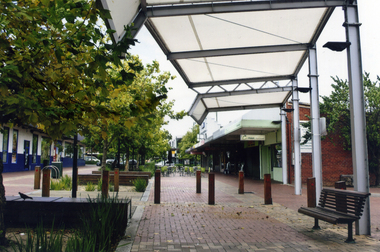 Whitehorse Historical Society Inc.
Photograph, Brittania Mall Mitcham
... Street and Brittania Street, part of which had to be re-routed... both Edward Street and Brittania Street, part of which had ...The Brittania Mall was part of a $5 million development of the Mitcham Shopping centre, begun in 1986. It affected both Edward Street and Brittania Street, part of which had to be re-routed. The guide hall in Brittania Street was removed to Halliday Park Mitcham. The development included extension of the New World Supermarket(now Coles) and a two level carpark.Coloured photograph of the Britannia Mall, Mitcham taken from the north end. Traffic in the distance is on Whitehorse Road - 2012shops, britannia mall, mitcham -
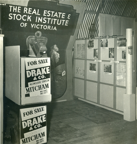 Whitehorse Historical Society Inc.
Photograph, Drake & Co, Mitcham
... Street and Colombo Street, Mitcham.. In 1926 Norman Armstrong... of Station Street and Colombo Street, Mitcham.. In 1926 Norman ...In 1914, Frederick C Drake opened Mitcham's first estate agency in a red brick office building on the corner of Station Street and Colombo Street, Mitcham.. In 1926 Norman Armstrong took over the business but retained the original name. In the early 2000s the agency was sold to Philip Webb Real Estate and the Drake & Co name ceased to exist.Black and white photo of the interior of Drake & Company office, Real Estate Agents of Mitcham.drake & co, real estate agents -
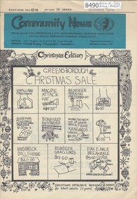 Greensborough Historical Society
Newsletter, Greenhills and North Greensborough Progress Association, Community News: official journal of the Greenhills and Nth. Greensborough Progress Association and the Apollo Parkways Progress Association. December 1978. Edition No. 11/78, 12/1978
... Kindergarten], Tasmania... treasure island, Planting in Mine Street... Kindergarten], Tasmania... treasure island, Planting in Mine Street ...Editorial [from resigning editor Chris Borgeest], John O'Connor, [Extracts from written thoughts of parents from Yandell Kindergarten], Tasmania... treasure island, Planting in Mine Street Group of Streets, Montmorency Horticultural Society, Diamond Valley Repertory, From the Council Chamber. A digitised copy of this newsletter is available at Greensborough Historical Society.Newsletter, 16 p., illus.greenhills and north greensborough progress association, greenhills, apollo parkways progress association, apollo parkways -
Glenelg Shire Council Cultural Collection
Print - Contact Print - Eumeralla, Cape Nelson and Lighthouse, Cape Nelson Road / Must Street, 1960-1979
... Nelson Road / Must Street... Must Street... Street looking towards Bentinck Street. Man standing... Cliff Street Portland great-ocean-road SS Eumeralla Cape Nelson ...Sheet of 3 pairs stereoscopic contact prints from glass plate negatives. Top: Top deck of 'Eumeralla' Middle: Cape Nelson and Lighthouse Bottom: Corner Cape Nelson Road and Must Street looking towards Bentinck Street. Man standing in intersection holding 2 bicycles.ss eumeralla, cape nelson, must street, cape nelson lighthouse, cape nelson road -
 Stawell Historical Society Inc
Photograph, Patrick Street and the Corner of Sloane Street with Stawell Court House in the background & St Patricks Church on the Horizon 1878
... Patrick Street and the Corner of Sloane Street with Stawell...Patrick Street Sloane Street intersection in the 1880’s... grampians Patrick Street Sloane Street intersection in the 1880’s ...Patrick Street Sloane Street intersection in the 1880’s (Herbert Photo) On Big Hill side of Patrick Street is Matthew Cairns Plumber & Gasfitter, R. Greenwood Tailor, Mrs. Goodwin Cafe & Restaurant, Mack's Hotel, Grocer, Boot and Shoemaker, J. Farleys Auction Room, J.B. Wallis Royal Exchange Hotel, Stawell Court House and St Patricks Church in Distance On corner of Patrick and Sloane Streets, Melbourne Cash Store Wine Spirits & Provisions. In background mining poppet head behind livery stable. St Patrick Church in distance on right. 1878Patrick St, Sloane St intersection looking south . The Stawell Library now occupies this corner.Victorian Views. C. Herbert, Photo. Stawell 1878stawell business streetscape -
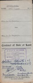 Bendigo Historical Society Inc.
Document - H.A. & S.R. WILKINSON COLLECTION: CONDITION OF SALE
... residence area No. 285 and situate No. 88 Old Violet Street Corner... Inc. History House 11 Mackenzie Street Bendigo goldfields ...Contract of sale of land issued by H.A. Wilkinson dated 25th August 1953 between Mr. G. A. Harris (seller) and Mr. D.R. Raggatt for land being allotment 15Bsection 51B Parish of Sandhurst City and County of Bendigo described in right to occupy residence area No. 285 and situate No. 88 Old Violet Street Corner Lilac Street Bendigo, with weatherboard dwelling and all sundry. Price 3,800 poundsorganization, business, h.a. & s.r wilkinson real estate -
Clunes Museum
Photograph
... .1 PHOTOGRAPH OF CORNER OF FRASER STREET AND SERVICE STREET...Clunes Museum 36 Fraser Street Clunes goldfields EASTER ....1 PHOTOGRAPH OF CORNER OF FRASER STREET AND SERVICE STREET WITH THE SUPERMARKET AND SIGN OVER CROSSING "WELCOME" .2 PHOTOGRAPH EASTER 1982, BACK TO CLUNES, COLOURFUL TRUCK - TENNIS FLOAT .3 PHOTOGRAPH EASTER 1982, PEOPLE IN FRONT OF GARAGE WATCHING THE PARADE. IN FRONT MISS PIGGY PUSHING A PRAM .4 SEVEN LITTLE DWARFS - DONE MY CLUNES GOLF CLUB LADIES, PAINTED BY JAN RUBINSKI, EASTER 1982easter parade, back to clunes -
 Lakes Entrance Historical Society
Postcard - Backwater, Bulmer H D, 1922c
... Street and Roadknight Street, very little vegetation on sand... went along Esplanade, Myer Street and Roadknight Street, very ...Black and white photographic postcard, showing early aerial view of township of Lakes Entrance, Cunninghame Arm, North Arm and sand dunes, ocean in lower foreground, Eastern wharf and various boats on lake. Princes Highway went along Esplanade, Myer Street and Roadknight Street, very little vegetation on sand dunes, no foot bridge yet, good view of North Arm, few houses. Lakes Entrance VictoriaLakes Entrance and Backwater from the Air.islands, aerial photograph, waterways, topography, township -
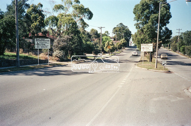 Eltham District Historical Society Inc
Negative - Photograph, Main Road, Eltham, c.Dec. 1983
... to Lower Plenty and Templestowe to be diverted down Bridge Street... Street (and Bolton Street) effective January 1984. The proposed ...Road sign advising of proposed reconstruction works of Main Road to install a roundabout at Mount Pleasant Road. Traffic to Lower Plenty and Templestowe to be diverted down Bridge Street (and Bolton Street) effective January 1984. The proposed roundabout did not proceed. Instead traffic islands on Mount Pleasant Road were installed in place of temporary blocked out islands.Film - Kodak CM 400 5079 7 strips, 26 framesinfrastructure, roads, road construction, roundabout, road sign, main road, mount pleasant road -
 Eltham District Historical Society Inc
Photograph, E. Strawbridge, Caroline Shillinglaw (1876-1956), c.1896
... Street in April 1882. She married Christopher Watson on 23 Oct... Street in April 1882. She married Christopher Watson on 23 Oct ...Caroline (Carrie) Shillinglaw was the third child of Phillip and Sarah Shillinglaw, born 29 February 1876 in Bundoora. She commenced school at Eltham State School No. 209 in Dalton Street in April 1882. She married Christopher Watson on 23 Oct. 1907. Christopher Watson was the owner of Watson's Hotel on the corner of Pitt Street and Maria Street (Main Road).E. Strawbridge 129 Park St. Parkville Melbournecaroline shillinglaw, caroline watson (nee shillinglaw), caroline (carrie) watson (nee shillinglaw 1876-1956), carrie shillinglaw -
 Greensborough Historical Society
Map, Melbourne and Metropolitan Board of Works. Survey Division, MMBW, Yarra 2500 / 13.19. Lower Plenty, Montmorency, Yallambie, 1979_02
... , Diamond Valley 257 and Eltham 238. Prominent streets include.... Prominent streets include: Elder Street, Para Road, and Main Road ...Melbourne and Metropolitan Board of Works. Yarra 2500 [base map] 13-19. Lower Plenty, Montmorency, Yallambie. Parishes of Keelbundora 2856 and Nillumbik 3310. Municipalities of Heidelberg 228, Diamond Valley 257 and Eltham 238. Prominent streets include: Elder Street, Para Road, and Main Road Lower Plenty. Includes Watsonia Army Barracks.MMBW Map in 1:2500 [scale] series. Cream parchment with green tape reinforcing on edges and punched holes on left edge.mmbw, melbourne and metropolitan board of works, shire of diamond valley, montmorency - maps, yallambie - maps, lower plenty - maps -
 Rutherglen Historical Society
Images, 1970s
... . Post Office lane ran from Main Street to Reid Street, and much...Rutherglen Historical Society Murray Street Rutherglen high ...One of a collection of photographs from the Iggsten Estate. Post Office lane ran from Main Street to Reid Street, and much of it is now the car park for the IGA Supermarket. The Main Street end between the supermarket and the post office is closed to all but pedestrian traffic, and is now called Gollings Square. It is a rest area with trees, garden, sculptures and benches. Colour photograph showing the Victoria Hotel from the vantage point of Post Office Lane.victoria hotel, post office lane, florence iggsten, gollings square -
 Rutherglen Historical Society
Images, 1970s
... . Post Office lane ran from Main Street to Reid Street, and much...Rutherglen Historical Society Murray Street Rutherglen high ...One of a collection of photographs from the Iggsten Estate. Post Office lane ran from Main Street to Reid Street, and much of it is now the car park for the IGA Supermarket. The Main Street end between the supermarket and the post office is closed to all but pedestrian traffic, and is now called Gollings Square. It is a rest area with trees, garden, sculptures and benches.Colour photograph taken in Post Office Lane, Rutherglen. The front of the Victoria Hotel is visible at the end of the road.post office lane, post offices, victoria hotel, florence iggsten, gollings square -
 Rutherglen Historical Society
Images, 1970s
... . Post Office lane ran from Main Street to Reid Street, and much...Rutherglen Historical Society Murray Street Rutherglen high ...One of a collection of photographs from the Iggsten Estate. Post Office lane ran from Main Street to Reid Street, and much of it is now the car park for the IGA Supermarket. The Main Street end between the supermarket and the post office is closed to all but pedestrian traffic, and is now called Gollings Square. It is a rest area with trees, garden, sculptures and benches. Colour photograph showing the Victoria Hotel from the vantage point of Post Office Lane.victoria hotel, post office lane, florence iggsten, gollings square -
 Bacchus Marsh & District Historical Society
Map, Plan of Survey of Part of Crown Allotment 9, Parish of Korkuperrimul, 1890
... Clarke Street Bacchus Marsh Maps... in Clarke Street Bacchus Marsh in 1890. Clarke Street is located... in Clarke Street Bacchus Marsh in 1890. Clarke Street is located ...This map documents a transfer of an allotment of land in Clarke Street Bacchus Marsh in 1890. Clarke Street is located on the eastern side of Bacchus Marsh not far from Main Street and Crook Street. It is now known as Candeloro Street. The map indicates J. Booth as the owner of the land and H. Simpson as the occupier. Next to this allotment is a an allotment of land owned by J. Elmore,Single page map showing Crown allotment 9, Parish of Korkuperrimul, County of Bourke. Scale 100 feet to inch. Part of a set of maps which are pasted into a bound volume containing 76 maps or plans in total. High resolution digital image stored on BMDHS computer network. At bottom of map: I hereby certify that I have made this survey expressly for the purpose of an application under the Transfer of Land Statute that this plan is correct. Barry B???, Lic. Surveyor, 16.10.90bacchus marsh victoria maps, clarke street bacchus marsh maps -
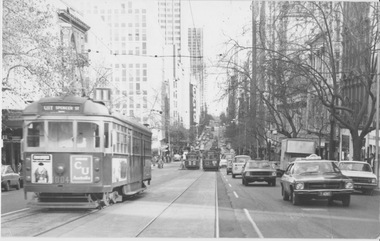 Melbourne Tram Museum
Photograph - W7 class 1004 in Collins Street, 1970s
... W7 class 1004 in Collins Street... Street approaching Swanston Street displaying destination "City... Street approaching Swanston Street displaying destination "City ...Photograph of W7 class tram 1004 westbound in Collins Street approaching Swanston Street displaying destination "City Spencer St route 11". The photograph looks westward, showing a long length of Collins Street with numerous trams and motor vehicles including a taxi. The trams are fitted with side lights from the early 1970s and most trees are without leavesYields information about trams and traffic in Melbourne CBD. Black and white photograph with nothing on rearfnptt, r class, plenty road, preston, span poles, track loop, melbourne and metropolitan tramways board, fnptt number 1, tram number 151 -
 The Beechworth Burke Museum Research Collection
Card (Series) - Photographs, George Tibbits, Ford Street, Beechworth, 1976
... Ford Street, Beechworth...Property - Views looking up and down Ford Street Beechworth... Street Beechworth Property - Views looking up and down Ford ...George Tibbits, University of Melbourne. Faculty of Architecture, Building and Town & Regional PlanningIndex system that support the research for Beechworth : historical reconstruction / [by] George Tibbits ... [et al]Arranged by street names of BeechworthEach index card includes: street name and number of property, image of property, allotment and section number, property owners and dates of ownership, description of the property according to rate records, property floor plan with dimensions.beechworth, george tibbitsbeechworth, george tibbits -
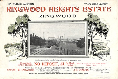 Ringwood and District Historical Society
Flyer, Subdivision Advertisement - Ringwood Heights Estate Public Auction - March, 1924
... Street, and Mary Street. (Agents) Knight & Harwood, 315 Collins..., Heatherbrae Avenue, Margaret Street, and Mary Street. (Agents) Knight ...Refer also to Reg. No. 5185 for Ringwood Heights Estate final section release (August 1924)Folded double-sided brochure advertising Ringwood Heights Estate Public Auction on Saturday March 1, 1924, with town photographs, location map, terms of sale, and summary of local features and services.Subdivision includes Whitehorse Road, Bon View Avenue, Grant Crescent, Hillcrest Avenue, Heatherbrae Avenue, Margaret Street, and Mary Street. (Agents) Knight & Harwood, 315 Collins Street, Melbourne, Phones Central 10615, 10616, in conjunction with J.B. McAlpin, Opposite Railway Station, Ringwood, Phone Ringwood 7. -
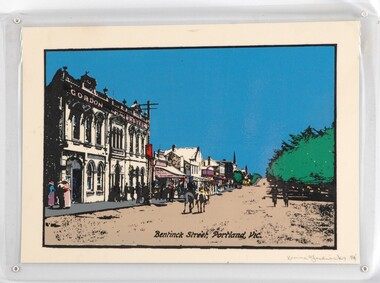 Glenelg Shire Council Cultural Collection
Print - Print - Bentinck Street, 1984
... Print - Bentinck Street...Laminated screenprint depicting an early street scene... Cliff Street Portland great-ocean-road CEMA Art Collection Part ...CEMA Art Collection Part of "A Community View" 150 years in Portland Screenprint Exhibition Part of the Angela Gee Residency 1983 and 1984Laminated screenprint depicting an early street scene of Bentinck Street in Portland. The left side of the work depicts the row of buildings along Bentinck Street with the 'Gordon Hotel' in the foreground. In the centre of the image two figures on horses ride away from the viewer. On the right is a large tree with with two figures walking below it.Front: Karina Fredericks 84' (lower right) (pencil) Back: 9