Showing 2665 items
matching 1980s
-
 Eltham District Historical Society Inc
Photograph, Liz Pidgeon, Heritage Excursion; Maroondah Aqueduct, 3 September 2016, 3 September 2016
Newsletter No., 229, August 2016 Heritage Excursion - Maroondah Aqueduct Walk - Saturday 3rd September The Maroondah Aqueduct was once a major link in Melbourne’s water supply system. It was built between 1886 and 1891 to transfer water from the Watts River near Healesville to the Preston Reservoir. It was 66 km in length, made up of 41 km of open channel, 10 km of tunnel through hills and 15 km of pipeline across stream valleys known as inverted siphons. The section of the aqueduct through the Eltham area has been abandoned since the 1980s but the open channel has largely been retained. A recreational path follows the aqueduct reserve. For our excursion on 3rd September we intend to walk along the section of the aqueduct adjacent to Allendale Road. This is a section not visited on previous excursions and includes the transition from open channel to the inverted siphon across the Diamond Creek valley. Apart from the aqueduct itself the main feature of the walk is the extensive views across Eltham North and Diamond Creek. Along the way we will talk about the history of the aqueduct and the area. This easy walk is about 3 km return and will take 2 to 2.5 hours. It will start at 2pm at the junction of Allendale Road with Godber Road and Zig Zag Road North, officially Diamond Creek, but on the northern boundary of Eltham. (Melway ref.12 B10). Born Digitalmaroondah aqueduct, eltham north, activities, eltham district historical society, heritage excursion, aqueduct trail, open channel, pipe -
 Eltham District Historical Society Inc
Photograph, Liz Pidgeon, Heritage Excursion; Maroondah Aqueduct, 3 September 2016, 3 September 2016
Newsletter No., 229, August 2016 Heritage Excursion - Maroondah Aqueduct Walk - Saturday 3rd September The Maroondah Aqueduct was once a major link in Melbourne’s water supply system. It was built between 1886 and 1891 to transfer water from the Watts River near Healesville to the Preston Reservoir. It was 66 km in length, made up of 41 km of open channel, 10 km of tunnel through hills and 15 km of pipeline across stream valleys known as inverted siphons. The section of the aqueduct through the Eltham area has been abandoned since the 1980s but the open channel has largely been retained. A recreational path follows the aqueduct reserve. For our excursion on 3rd September we intend to walk along the section of the aqueduct adjacent to Allendale Road. This is a section not visited on previous excursions and includes the transition from open channel to the inverted siphon across the Diamond Creek valley. Apart from the aqueduct itself the main feature of the walk is the extensive views across Eltham North and Diamond Creek. Along the way we will talk about the history of the aqueduct and the area. This easy walk is about 3 km return and will take 2 to 2.5 hours. It will start at 2pm at the junction of Allendale Road with Godber Road and Zig Zag Road North, officially Diamond Creek, but on the northern boundary of Eltham. (Melway ref.12 B10). Born Digitalmaroondah aqueduct, eltham north, activities, eltham district historical society, heritage excursion, aqueduct trail -
 Eltham District Historical Society Inc
Photograph, Liz Pidgeon, Heritage Excursion; Maroondah Aqueduct, 3 September 2016, 3 September 2016
Newsletter No., 229, August 2016 Heritage Excursion - Maroondah Aqueduct Walk - Saturday 3rd September The Maroondah Aqueduct was once a major link in Melbourne’s water supply system. It was built between 1886 and 1891 to transfer water from the Watts River near Healesville to the Preston Reservoir. It was 66 km in length, made up of 41 km of open channel, 10 km of tunnel through hills and 15 km of pipeline across stream valleys known as inverted siphons. The section of the aqueduct through the Eltham area has been abandoned since the 1980s but the open channel has largely been retained. A recreational path follows the aqueduct reserve. For our excursion on 3rd September we intend to walk along the section of the aqueduct adjacent to Allendale Road. This is a section not visited on previous excursions and includes the transition from open channel to the inverted siphon across the Diamond Creek valley. Apart from the aqueduct itself the main feature of the walk is the extensive views across Eltham North and Diamond Creek. Along the way we will talk about the history of the aqueduct and the area. This easy walk is about 3 km return and will take 2 to 2.5 hours. It will start at 2pm at the junction of Allendale Road with Godber Road and Zig Zag Road North, officially Diamond Creek, but on the northern boundary of Eltham. (Melway ref.12 B10). Born Digitalmaroondah aqueduct, eltham north, activities, eltham district historical society, heritage excursion, aqueduct trail, russell yeoman -
 Eltham District Historical Society Inc
Photograph, Liz Pidgeon, Heritage Excursion; Maroondah Aqueduct, 3 September 2016, 3 September 2016
Newsletter No., 229, August 2016 Heritage Excursion - Maroondah Aqueduct Walk - Saturday 3rd September The Maroondah Aqueduct was once a major link in Melbourne’s water supply system. It was built between 1886 and 1891 to transfer water from the Watts River near Healesville to the Preston Reservoir. It was 66 km in length, made up of 41 km of open channel, 10 km of tunnel through hills and 15 km of pipeline across stream valleys known as inverted siphons. The section of the aqueduct through the Eltham area has been abandoned since the 1980s but the open channel has largely been retained. A recreational path follows the aqueduct reserve. For our excursion on 3rd September we intend to walk along the section of the aqueduct adjacent to Allendale Road. This is a section not visited on previous excursions and includes the transition from open channel to the inverted siphon across the Diamond Creek valley. Apart from the aqueduct itself the main feature of the walk is the extensive views across Eltham North and Diamond Creek. Along the way we will talk about the history of the aqueduct and the area. This easy walk is about 3 km return and will take 2 to 2.5 hours. It will start at 2pm at the junction of Allendale Road with Godber Road and Zig Zag Road North, officially Diamond Creek, but on the northern boundary of Eltham. (Melway ref.12 B10). Born Digitalmaroondah aqueduct, eltham north, activities, eltham district historical society, heritage excursion, aqueduct trail -
 Eltham District Historical Society Inc
Photograph, Liz Pidgeon, Heritage Excursion; Maroondah Aqueduct, 3 September 2016, 3 September 2016
Newsletter No., 229, August 2016 Heritage Excursion - Maroondah Aqueduct Walk - Saturday 3rd September The Maroondah Aqueduct was once a major link in Melbourne’s water supply system. It was built between 1886 and 1891 to transfer water from the Watts River near Healesville to the Preston Reservoir. It was 66 km in length, made up of 41 km of open channel, 10 km of tunnel through hills and 15 km of pipeline across stream valleys known as inverted siphons. The section of the aqueduct through the Eltham area has been abandoned since the 1980s but the open channel has largely been retained. A recreational path follows the aqueduct reserve. For our excursion on 3rd September we intend to walk along the section of the aqueduct adjacent to Allendale Road. This is a section not visited on previous excursions and includes the transition from open channel to the inverted siphon across the Diamond Creek valley. Apart from the aqueduct itself the main feature of the walk is the extensive views across Eltham North and Diamond Creek. Along the way we will talk about the history of the aqueduct and the area. This easy walk is about 3 km return and will take 2 to 2.5 hours. It will start at 2pm at the junction of Allendale Road with Godber Road and Zig Zag Road North, officially Diamond Creek, but on the northern boundary of Eltham. (Melway ref.12 B10). Born Digitalmaroondah aqueduct, eltham north, activities, eltham district historical society, heritage excursion, aqueduct trail, open channel -
 Eltham District Historical Society Inc
Photograph, Liz Pidgeon, Heritage Excursion; Maroondah Aqueduct, 3 September 2016, 3 September 2016
Newsletter No., 229, August 2016 Heritage Excursion - Maroondah Aqueduct Walk - Saturday 3rd September The Maroondah Aqueduct was once a major link in Melbourne’s water supply system. It was built between 1886 and 1891 to transfer water from the Watts River near Healesville to the Preston Reservoir. It was 66 km in length, made up of 41 km of open channel, 10 km of tunnel through hills and 15 km of pipeline across stream valleys known as inverted siphons. The section of the aqueduct through the Eltham area has been abandoned since the 1980s but the open channel has largely been retained. A recreational path follows the aqueduct reserve. For our excursion on 3rd September we intend to walk along the section of the aqueduct adjacent to Allendale Road. This is a section not visited on previous excursions and includes the transition from open channel to the inverted siphon across the Diamond Creek valley. Apart from the aqueduct itself the main feature of the walk is the extensive views across Eltham North and Diamond Creek. Along the way we will talk about the history of the aqueduct and the area. This easy walk is about 3 km return and will take 2 to 2.5 hours. It will start at 2pm at the junction of Allendale Road with Godber Road and Zig Zag Road North, officially Diamond Creek, but on the northern boundary of Eltham. (Melway ref.12 B10). Born Digitalmaroondah aqueduct, eltham north, activities, eltham district historical society, heritage excursion -
 Eltham District Historical Society Inc
Photograph, Liz Pidgeon, Heritage Excursion; Maroondah Aqueduct, 3 September 2016, 3 September 2016
Newsletter No., 229, August 2016 Heritage Excursion - Maroondah Aqueduct Walk - Saturday 3rd September The Maroondah Aqueduct was once a major link in Melbourne’s water supply system. It was built between 1886 and 1891 to transfer water from the Watts River near Healesville to the Preston Reservoir. It was 66 km in length, made up of 41 km of open channel, 10 km of tunnel through hills and 15 km of pipeline across stream valleys known as inverted siphons. The section of the aqueduct through the Eltham area has been abandoned since the 1980s but the open channel has largely been retained. A recreational path follows the aqueduct reserve. For our excursion on 3rd September we intend to walk along the section of the aqueduct adjacent to Allendale Road. This is a section not visited on previous excursions and includes the transition from open channel to the inverted siphon across the Diamond Creek valley. Apart from the aqueduct itself the main feature of the walk is the extensive views across Eltham North and Diamond Creek. Along the way we will talk about the history of the aqueduct and the area. This easy walk is about 3 km return and will take 2 to 2.5 hours. It will start at 2pm at the junction of Allendale Road with Godber Road and Zig Zag Road North, officially Diamond Creek, but on the northern boundary of Eltham. (Melway ref.12 B10). Born Digitalmaroondah aqueduct, eltham north, activities, eltham district historical society, heritage excursion, aqueduct trail -
 Eltham District Historical Society Inc
Photograph, Liz Pidgeon, Heritage Excursion; Maroondah Aqueduct, 3 September 2016, 3 September 2016
Newsletter No., 229, August 2016 Heritage Excursion - Maroondah Aqueduct Walk - Saturday 3rd September The Maroondah Aqueduct was once a major link in Melbourne’s water supply system. It was built between 1886 and 1891 to transfer water from the Watts River near Healesville to the Preston Reservoir. It was 66 km in length, made up of 41 km of open channel, 10 km of tunnel through hills and 15 km of pipeline across stream valleys known as inverted siphons. The section of the aqueduct through the Eltham area has been abandoned since the 1980s but the open channel has largely been retained. A recreational path follows the aqueduct reserve. For our excursion on 3rd September we intend to walk along the section of the aqueduct adjacent to Allendale Road. This is a section not visited on previous excursions and includes the transition from open channel to the inverted siphon across the Diamond Creek valley. Apart from the aqueduct itself the main feature of the walk is the extensive views across Eltham North and Diamond Creek. Along the way we will talk about the history of the aqueduct and the area. This easy walk is about 3 km return and will take 2 to 2.5 hours. It will start at 2pm at the junction of Allendale Road with Godber Road and Zig Zag Road North, officially Diamond Creek, but on the northern boundary of Eltham. (Melway ref.12 B10). Born Digitalmaroondah aqueduct, eltham north, activities, eltham district historical society, heritage excursion, aqueduct trail -
 Federation University Historical Collection
Booklet, Report on the Viability of Establishing a Post Secondary Education Facility Located at the Aradale Traininf Centre, Ararat, Victoria, 1993, 12/1993
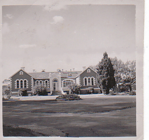
Aradale is located 3 km from the centre of Ararat and covers approximately 101 hectares. It consistes of an impresive group of mainly heritage buildings of national significance surrounded by open farmland. Aradale was designed in 1864 in the Victorian Italianate style by John James Clark of the Public Works Department, Victoria. A three storey nurses quarters was built in the 1930s and the Forensic Psychaitry Centre was established in the 1980s. The design of asylums as a specific building type orginated in England in the mddle of the 19th century when it was decided that 'pauper lunatics' would be better cared for in a separate institution rather than being house within the workhouses. Some of the early purpose built asylums were based on the radiating principle of prisons but the arrangement of separat wings at right angles used in hospitals and whorkhouse design soon came to be seen as the most appropriate. The largest 19th century asylum in England was built at Colney Hatch. Kew, Beechworth and Ararat Asylums closely followed the Colney Hatch model. In victoria the population rose due to the gold rushes resulting in severe housing shortages, and additional pressure on asylums. The first asylum in Melbourne was established at Y arra Bend. In 1862 a new asylum was established at Kew. Ararat Asylum and Beechworth Asylum were designed in 1864. Ararat was opened on 19 October 1867, with Beechworth Asylum opening five days later. Soft covered bookletararat regional development board inc., aradale training centre, aradale, grano street ararat, alfred st ararat, ivar nelson, john christie, jon duggan, wes matthews, peter helfer, michael burke, john grant, asylum, lunatic asylum, colney hatch asylum, ararat asylum, fever tents, sunbury asylum, kew asylum, beechworth asylum, wine industry training -
 Department of Health and Human Services
Photograph, Front of building and roundabout of Pleasant Creek Special School - Stawell - Circa 1940 to 1950
Pleasant Creek Colony history in brief Warning about distressing information Patient information Disclaimer Source On this page: Pleasant Creek Colony history in brief Warning about distressing information Patient information Disclaimer Source Pleasant Creek Colony history in brief In 1861, the Pleasant Creek Hospital opened as a medical facility for the population of Stawell and district. Another building was added in 1904, Syme Ward for convalescent patients. In 1933, the facility was replaced by a newly-built hospital in the town of Stawell. In 1934, the Mental Hygiene Department acquired the old Pleasant Creek Hospital site and converted it to accommodate children with disabilities, which became Pleasant Creek Special School. The first residents (18 boys) were admitted in 1937 from Royal Park Depot. At the end of 1937, there were 98 children living at Pleasant Creek. In 1968 the Pleasant Creek Special School was renamed Pleasant Creek Training Centre, caring for people with intellectual disabilities. From the 1950s to the 1980s, there were several building developments: •1957, Lonsdale Unit expanded capacity to 113 •1969, Bellfield and Fyans Units increased numbers to 196 •1977, Alexandra Unit converted to recreational and lecture room facility. •1977, Day Centre, Nurses' Home and Clinical Services Administration buildings •1985, Nara Unit closed for renovations and residents moved to the previous staff living quarters. https://www.findingrecords.dhhs.vic.gov.au/CollectionResultsPage/Pleasant-Creek-Colony -
 Federation University Art Collection
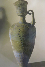
Ceramic, Dry Glaze Bottle by Alan Peascod, c1980
Alan PEASCOD (1943-2007). Born England. Arrived Australia 1952. Alan Peascod was one of Australia’s most highly acclaimed ceramic artists. For over 35 years his work has been at the forefront of the Australian ceramics movement, developing radical techniques previously unexplored with his developments in unusual glazes and firing methods. His creative repertoire includes dry glazed vessels, alkaline glazes, majolica, saturated metals, and many post firing finishes. Alan's work with the very difficult reduced lustre technique is highly regarded. He was taught the method by Professor Said El Sadr in Cairo, Egypt in 1972 and this led to lifelong research of the technique throughout the Middle East and Europe. His work in the field led to the completion of his doctoral studies at the University of Wollongong in 1994. This study also led to satirical figurative sculpture themes dealing with the human condition. This work is part of the Jan Feder Memorial Ceramics Collection. Jan Feder was an alumna of the Gippsland Campus who studied ceramics on the campus. She passed away in the mid 1980s. Her student peers raised funds to buy ceramic works in her memory. They bought works from visiting lecturers who became leading ceramic artists around the world, as well as from many of the staff who taught there.Blue and green dry glaze bottle. alan peascod, ceramics, gippsland, jan feder memorial ceramics collection, gippsland campus, visiting artist -
 Wodonga & District Historical Society Inc
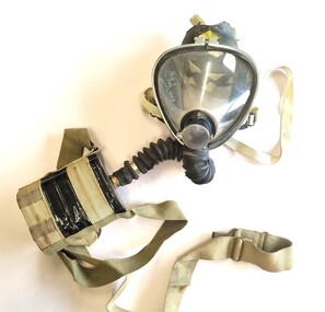
Tool - Sieba Gordon Gas Mask - North East Water Authority, Siebe Gorman & Co. Ltd, c1960
This mask set is part of the North East Region Water Authority collection in the Wodonga Historical Society. Wodonga's drinking water and wastewater operations were originally managed by the Wodonga Waterworks Trust, which was established in 1897, after Wodonga became a separate shire in 1876. In 1923 a Wodonga Waterworks Trust referendum to provide funding for new infrastructure to supply more water of better quality to Wodonga was passed. This included building the Wodonga Water Tower and it was completed in 1924. It supplied water to Wodonga until 1959, when it was drained and decommissioned after the No 1 Basin on Huon Hill was completed in 1958. In 1983 the Wodonga Waterworks Trust and the Wodonga Sewerage Authority became part of the Wodonga Council. And by 1989 a filtration plant at Huon Hill was completed, which provided filtered water of improved quality to Wodonga, in accordance with the World Health Organisation’s guidelines. In 1994 the Kiewa Murray Region Water Authority took over the Wodonga Council’s water and wastewater operations, and then in 1999 the Kiewa Murray Region Water Authority combined with the Ovens Region Water Authority and became the North East Region Water Authority or NERWA. NERWA then became known as North East Water. Siebe Gorman was a British manufacturer of industrial respirators that served the mining industry, the chemical industry, and the agricultural industry from 1938 until the 1980s. The "Puretha" line refers to the canister included, which was designed to tackle industrial hazards.Siebe Gorman "Puretha" Type C Kit with Vista Vision Facepiece. The facepiece consists of a formed plastic lens held on by a white retaining ring that stretches around the rubber facepiece and is connected by two thumbscrew lugs. The exhale assembly is covered by a steel mesh.The hose is a standard industrial hose. The canister is attached by a khaki webbing material. An instruction sheet is included. The kit is a small leather case with two front latches. Safety instructions and chemical information on canister label. On label: EVERYTHING FOR SAFETY EVERYWHERE Date filled 28 DEC 1961 NO. 675 north east region water authority, gas mask, respirator, sieba gordon -
 Falls Creek Historical Society
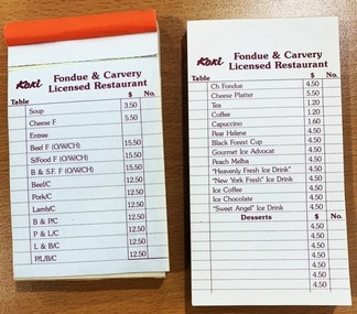
Ephemera - Koki Restaurant docket and order book
Order docket books used at Koki Fondue and Carvery Restaurant in Falls Creek during 1975. Shows menu items and price as well as how orders were taken. George Shirling arrived in Falls Creek in 1962. He engaged Phil Nowell to build the original Koki Alpine Lodge which opened in 1965 with 14 beds. George operated the lodge with Michael “Baldy” Blackwell as manager. He also graduated in sport psychology in 1981 and was invited to become team psychologist for the Australian Winter Olympic team which went to Albertville, France, in 1992. He later owned the Red Onion Chalet. George credited the success of Koki to “Baldy” Blackwell. “Baldy” and Phil Nowell started the Trackers Mountain Lodge in partnership during the 1980s. In 1971 George sold Koki Lodge to Sigh Doerr. Sigh was a long time resident of Falls Creek, owning and operating Koki Lodge for many years with his wife, Lee. He was Falls Creek CFA Captain from 1995 until 1998 although he served in the Fire Brigade for much longer. Sigh had many involvements in the community. In 2023 the renamed Koki Alpine resort remains a highly popular destination in Falls Creek operated by Doerr Nominees Pty. Ltd. under the management of Vesna Sugden.This item is significant because it has clear links to an iconic business established in Falls Creek, VictoriaTwo order docket books for Fondue and Carvery Licensed Restaurant, with paper connected at top edge with glue, each page containing name of restaurant at top of page with list of menu items and price in grid with section for table at left and order number at right. All printed in red. 'Koki / Fondue & Carvery / Licensed Restaurant'dining, 1970s dining, falls creek, koki, sigh doerr, george shirling -
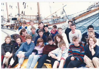 Melbourne Legacy
Photograph - Junior legatee outing, Alma Doepel, 1988
There was a program to send young legatees on trips on the Alma Doepel sailing ship through the 1980s and 90s. On the back of some photos were names: Junior Legatee Jane Hornblow (Canberra) / Legatee Keith Dale(?) / Junior Legatee Leonard Jono Bonnett (Adelaide). Also the same children with Legatee Scotty Scott (in a navy jacket). The articles from the Answer show timetables and criteria for nomination of junior legatees to be selected on the trips. One of these articles mentions the war service of the Alma Doepel - the only ship with served in World War II that was still active in 1995. These photos were in a folio of photos from 1988 to 1990. Official photos were taken by Peter from Keesing Photographers before the journey started on 27 December 1988 are at 01054. These photos were taken by a Legatee, L/ George Scott. Also at 01054 is a letter from a different voyage and is dated 30 December 1996 and sums up the outcomes of such trips. A Junior Legatee, Kim Anderson, wrote to Legacy thanking them for the opportunity to be on a 9 day voyage on the Alma Doepel. She mentions: "I learnt not only .. how to sail .. but also about teamwork, responsibility, friendship and respect." Also: "As one of the older children who attend these activities I feel I can now appreciate the thought and organisation that goes into these days and camps much more." Was in a scrapbook of photos spanning 1987 to 1991.A record of a Legacy providing amazing experiences for the junior legatees that they might never have done because of the deaths of their fathers.Colour photo x 5 of Junior Legatees on the Alma Doepel in 1988.White paper label handwritten in blue pen 'Please find enclosed some photos I took of Jun Legatees at Alma Doepel's sailing 27.12.88. May be of use to you for publicity. Legatee George Scott.' Two photos have names on the back in black pen. junior legatee outing, answer -
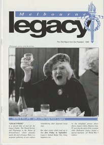 Melbourne Legacy
Document - Report, The 73rd Report from the President - 1996, 1996
In 1996 Legacy featured Beatrice Gay, a World War One widow on the cover toasting at the annual WW1 Widows lunch. The president was Ray Ward. The report also recaps events through the year such as the school students' Anzac commemoration service, legacy week and the public speaking contest. One article showcases Welfare and Housing with one widow, Mabel, having her house painted after receiving paint donated by the Gas and Fuel Corporation and the painting done by Legatees. Another article is about the Alma Doepel and the experience of Junior Legatee Kim Anderson. There is an article showing Daryl Somers opening Legacy week at with Hazel McKean, Lynne Scott, Elaine Ward and Junior Legatee Kim Anderson in attendance. Up to the 1980s the annual report would usually contain pages containing the Presidents report and photos of significant events of the year. Between 1987 and 1990 these were published in a separate document called 'Highlights from the Annual Report'. This could be used in promoting Legacy in different ways, without all the financial information normally held in an annual report. In following years it became called 'Report from the President' then 'Highlights from the President', before becoming 'Melbourne Legacy Highlights' which was published twice a year from 2007. It was eventually renamed, 'The Torch, Melbourne Legacy Highlights' in 2012. 'The Torch' is still published twice a year.A record of the annual reports of Legacy Melbourne, including activities and telling stories of Legacy's impact.Colour printed president’s report from 1996 x 8 pages, with black and white photos.annual summary, activities -
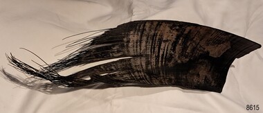 Flagstaff Hill Maritime Museum and Village
Animal specimen - Baleen
A baleen whale has hard bristly baleen that hangs from its upper jaw inside its mouth instead of teeth. Baleen is made from a protein called keratin, just like human hair and fingernails, and its colour can vary between species, from black to yellow or white. The whale uses the tough, flexible baleen like a sieve to catch its food, filtering the small sea creatures out of the sea water it releases from its mouth. In the19th Century, whales were hunted for the products that could be made from their bodies, such as oil for lubricating machinery, soap making, lamps, heaters and fuel for the lighthouse lights. The flexible baleen was used for whip handles, carriage springs and umbrella ribs. It was also used for the skirt hoops, hat ribs, and rigid ‘stays’ in tightly fitting bodices to enhance their figures. The Southern Right Whales, as well as Blue Whales and Humpback Whales, are baleen whales. The Southern Rights annually visit the ocean off the southwest coast during the breeding season. In the early 1800s whalers hunted along this coastline in their dangerous pursuit of money for the precious cargoes of whale oil and bones. The population of these large animals dwindled quickly and by the late 1840s the whaling industry dwindled. Whaling recommenced from the 1940s to the 1980s when the whale products were used to make margarine and dog food. The baleen sample has been used to educate people about whaling and about the properties of baleen. The baleen sample is significant for its association with 19th century women's fashion. It helps to understand how garments were supported to shape a woman's figure. The baleen sample represents a period when whales were hunted and killed to provide income and products for for the local settlers and for the export industry.Baleen sample from a whale's jaw. Its black shiny hard yet flexible surface is slightly rippled and textured. One end is fringed and the other and a smooth cut edge. The colour varies in places, with stripy brown colouring. flagstaff hill maritime museum and village, great ocean road, shipwreck coast, baleen, whalebone, baleen whale, keratin, 19th century, whaling industry, women's fashion, stays, bodice, women's figures, fashion, clothing, whale oil, baleen colour, whale hunting, whale products, southern right whale, blue whale, humpback whale, southwest victoria, whalers, whale bones -
 Kew Historical Society Inc
Plan, Melbourne & Metropolitan Board of Works : Borough of Kew : Detail Plan No.1585, 1904
The Melbourne and Metropolitan Board of Works (MMBW) plans were produced from the 1890s to the 1950s. They were crucial to the design and development of Melbourne's sewerage and drainage system. The plans, at a scale of 40 feet to 1 inch (1:480), provide a detailed historical record of Melbourne streetscapes and environmental features. Each plan covers one or two street blocks (roughly six streets), showing details of buildings, including garden layouts and ownership boundaries, and features such as laneways, drains, bridges, parks, municipal boundaries and other prominent landmarks as they existed at the time each plan was produced. (Source: State Library of Victoria)This plan forms part of a large group of MMBW plans and maps that was donated to the Society by the Mr Poulter, City Engineer of the City of Kew in 1989. Within this collection, thirty-five hand-coloured plans, backed with linen, are of statewide significance as they include annotations that provide details of construction materials used in buildings in the first decade of the 20th century as well as additional information about land ownership and usage. The copies in the Public Record Office Victoria and the State Library of Victoria are monochrome versions which do not denote building materials so that the maps in this collection are invaluable and unique tools for researchers and heritage consultants. A number of the plans are not held in the collection of the State Library of Victoria so they have the additional attribute of rarity.Original survey plan, issued by the MMBW to a contractor with responsibility for constructing sewers in the area identified on the plan within the Borough of Kew. The plan was at some stage hand-coloured, possibly by the contractor, but more likely by officers working in the Engineering Department of the Borough and later Town, then City of Kew. The hand-coloured sections of buildings on the plan were used to denote masonry or brick constructions (pink), weatherboard constructions (yellow), and public buildings (grey). This plan, which covers parts of High Street, Pakington Street and Derby Street is dominated by two historic Kew mansions: ‘Konetta’ and ‘Ramornie’. Ramornie was constructed in 1890 for James Maitland Campbell, three times Mayor of Kew. Sold in 1940, it became a boarding house known as ‘The Towers’. Now a private residence again, it has only one of its three balconies remaining. The location of the missing two balconies can be seen on the plan. In 1903, the grounds of Ramornie included a large tennis court fronting Pakington Street. The rear of the property is shown as extending to Cobden Street. One of Kew’s oldest hotels, the Prospect Hill Hotel on the corner of High and Cobden Street was established in 1858. The outline of the hotel shown on the plan represents the second building on the site. During the 19th century it was often used for electoral meetings. The Prospect Hill Hotel was to be redeveloped again in 1928, by the local architect Robert McIntyre. Since the 1980s, the hotel has been a live music venue, the home of the Melbourne Jazz Club, a restaurant and a liquor outlet.melbourne and metropolitan board of works, detail plans, maps - borough of kew, mmbw 1585, cartography -
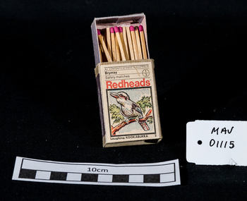 City of Moorabbin Historical Society (Operating the Box Cottage Museum)
Containers, matchbox 'Redhead' with matches, 20thC
On 15th December 1909, Bryant & May, Australia’s first match factory at Church Street, Richmond, Victoria. was opened by The Honourable Alfred Deakin, Prime Minister of Australia, and Mrs. Deakin. It was heralded by the first Commonwealth Government of newly-federated Australia because the government of the day was anxious to encourage secondary industry and pledged tariff protection of local manufacturers. The building was constructed in 1909 as the Empire Works to a design by prolific Melbourne architect William Pitt and was purchased soon after by British safety match manufacturer Bryant and May, who significantly expanded the building, adding another level and the landmark clock tower. Bryant and May were unique in that they operated as a model factory, providing workers with conditions and amenities that even today seem generous. These included a dining hall and sports facilities such as a tennis court and bowling green which were constructed in the 1920s. Bryant and May ceased Australian match manufacture in the early 1980s as a result of import competition. Their iconic Redheads matches are now imported from Sweden. The complex has since been converted for use as offices and showrooms but is extremely well preserved. It is listed on the Victorian Heritage Register. Bryant and May was a United Kingdom (UK) company created in the mid-nineteenth century specifically to make matches. Their original Bryant and May Factory was located in Bow, London. They later opened other match factories in the United Kingdom and Australia, such as the Bryant and May Factory, Melbourne; and owned match factories in other parts of the world. Bryant and May survived as an independent company for over seventy years, but went through a series of mergers with other match companies and later with consumer products companies. To protect its position Bryant and May merged with or took over its rivals. In 1971 the Northern Ireland factory, Maguire & Patterson closed down following a terrorist attack.. In the 1980s, factories in Gloucester and Glasgow closed too leaving Liverpool as the last match factory in the UK, until December 1994. . The registered trade name Bryant and May still exists and it is owned by Swedish Match, as are many of the other registered trade names of the other, formerly independent, companies within the Bryant and May group. Two French chemists, Henri Savene and Emile David Cahen, proved in 1898 that the addition of phosphorus sesquisulfide meant that the substance was not poisonous, that it could be used in a "strike-anywhere" match, and that the match heads were not explosive. British company Albright and Wilson, was the first company to produce phosphorus sesquisulfide ( Red Phosphorous) matches commercially. The company developed a safe means of making commercial quantities of phosphorus sesquisulfide in 1899 and started selling it to match manufacturers. Matches were first produced by Bryant & May in Australia in 1909. The Redhead name applies to the red striking heads of the matches which were introduced to Australia in 1946. The logo on the matchbox depicted the head and shoulder of a redheaded woman and has had four major updates since that time with a number of special issues depicting birds, animals and notable persons also produced.The Bryant & May Ltd factory in Church St Richmond is a listed building and has been converted to apartments following the closure of the Company 1980. Bryant & May's Ltd were influential in fighting against the dreadful disease known as Phossy jaw which was caused by white phosphorus used in the manufacture of the early matches. They were also the object of the 'Match Girls Strike' in London 1888, which won important improvements in working conditions and pay for the mostly female workforce working with the dangerous white phosphorus. The public were slow to purchase these safety matches because of the higher price .A box of safety matches with unused matches made by Bryant & May Pty Ltd , Richmond Victoria Australia. The tray containing the matches slides inside the open ended cover.. The striking patch is on both sides of the cover. Av. CONTENTS 50 MADE IN AUSTRALIA / Brymay / 1/3 / Safety Matches / Redheads / a colour picture of a Kookaburra / Laughing KOOKABURRAsafety matches, bryant & may pty ltd, phossy jaw disease, early settlers, moorabbin, bentleigh, cheltenham, lights, lamps, tobacco, white phosphorous, phosphorus sesquisulfide, swedish match pty ltd, pitt william, savens henri, cahen emile david , richmond victoria, -
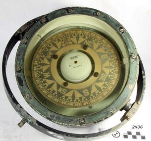 Flagstaff Hill Maritime Museum and Village
Compass, 1940's
Henry Browne and Son Ltd, of Barking, made aviation and nautical compasses, clocks and dials. The company made compasses for aircraft notably, Spitfires, Tiger moths and Concord. Henry Browne was born in Lewis, Sussex in 1842 and died in Barking in 1935. His company was a well respected English instrument maker that had been making and selling fine quality compasses, ship's clocks, inclinometers, sextants, and chandlery items for over 140 years. It started in a factory in Brightlingsea, Essex and moved to Barking in 1929. The Trade Mark brand Sestrel was used on all their equipment. Their “Dead Beat“ compass design is well dampened serving to reduce oscillations. It is reported that this design compass was fitted to many Allied ships during WW II. The company went through a boom period in the 1970s but collapsed in the 1980s due to the popularity of cheaper plastic compasses over tradition brass ones. Over more recent years, there has been a consolidation of British instrument makers and the firm of Henry Browne & Son has changed hands a number of times. At last count, it became part of Lillie & Gillie of London in 1985 when John Lilley & Gillie Ltd acquires the assets of Henry Browne & Sons (Sestrel) Ltd, a major competitor for what may be the second time. The model name of Sestral came about via the following.Take first two letters of the word Sensitive then the firs two letter of steady and the firs three letters of reliable hence the trade name of "Sestral". Item relates to the second world war used in many ships of the time merchant and military, It reminds us of a time in our social and world history when most of the world was in conflict.Henry Browne and Sons “Dead Beat“ compass design is well dampened serving to reduce oscillations and was an innervation that many makes of compass of the time din't have as a result the "Sestrel" design was fitted to many Allied ships during WW II.A liquid-filled Sestrel compass, with a brass housing and gimbal ring, wired for an internal low voltage light to illuminate the compass card. Inscriptions printed on face and impressed in metal around outer rim TRADE MARK", "Sestrel Dead-Beat", "No 1724 N", "Barking & London" HENRY BROWNE & SON", additional inscription "AFT No 1724 N". flagstaff hill, warrnambool, shipwrecked-coast, flagstaff-hill, flagstaff-hill-maritime-museum, maritime-museum, shipwreck-coast, flagstaff-hill-maritime-village, compass, marine compass, henry browne & son barking london, sestrel dead-beat marine compass, navigation instrument, sestrel dead-beat marine compass -
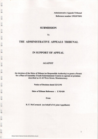 Eltham District Historical Society Inc
Document - Folder, Ron F. McCormack, Appeal against Eltham Shire Permit granted for a propsed Youth Enterntainment Centre, 41-43 Were Street, Montmorency, 1993-1994
In 1993 Eltham Shire Council issued a permit to Michael Muzur, Terry Lant and Andrew McMillan to redevelop the former Montmorency Theatre/Bingo Hall at 41-43 Were Street as an alcohol-free youth entertainment centre. Ron McCormack, retired former JP on behalf of 41 Joint Appellants consisting of local residents and traders successfully lobbied the community and won an Appeal to have the permit cancelled as unsuitable development. The Administrative Appeal Tribunal found that the proposed development came withing the Eltham Planning Scheme definition of an 'amusement parlour' and that the playing of pool an amusement machines would be the focus of the centre and unlikely to attract older age groups. The tribunal was not satisfied the applicants had sufficient knowledge or where with all required for the successful running of this type of operation. With respect to the objectors, the Tribunal did not accept that a responsibly managed and attractive amusement parlour could not coexist near the adjoining residential area and without detriment to the commercial centre. At a Council meeting on June 7, 1994 councillors requested a report outlining criteria to be used to assess planning applications for youth entertainment venues given the Tribunal's view that a poorly managed facility in a small neighbourhood shopping centre, particularly in such close proximity to a residential area would not only have the potential to increase perceived youth problems, but could jeopardise the prospects of future proposals. Ron McCormack moved to Montmorency from Coburg in the early 1980s and from then sat on the bench at Eltham Courthouse when Police requested assistance out of hours, until the eventuial closure of the Courthouse. montmorency theatre, montmorency bingo hall, 41-43 were street, youth entertainment centre, eltham shire council, planning permit, administrative appeals tribunal, ron f mccormack -
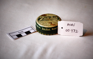 City of Moorabbin Historical Society (Operating the Box Cottage Museum)
Containers, tin ‘Zam-Buk’ ointment, c1980
Charles Edward Fulford, Ltd Leeds, England. The company founded in Australia in 1897 produced patent medicines, manufacturing products including Bile Beans and Zam-Buk ointment. Charles concocted ‘Bile Beans for Biliousness’, supposedly from a secret native recipe discovered by an eminent scientist – all a myth! Phenomenal sales were achieved through door-to-door leafleting, free gifts, and blanket advertising in the popular press, featuring emotive personal stories of miraculous, life-changing cures, presented as news items. The Company was first established in the UK in 1899 after achieving success in Australia. Charles’ brother Frank Harris Fulford, and entrepreneur, came from Canada to Leeds in 1902 to manage the British division of Charles's manufacturing business, C. E. Fulford Limited The company had to face damaging adverse publicity in 1905 when the judge in a case over the Bile Beans name declared that the business was founded on ‘fraud, impudence and advertisement’. But it survived, indeed flourished, expanding internationally. His other ‘secret’ remedy, Zambuk ointment was claimed to soothe and heal every kind of skin condition, an essential standby for all good mothers and wives. Both products lasted into the 1980s, after various company take-overs; interestingly, Zambuk has recently been revived. 1906 Charles Fulford, only 36, died at his home in Australia, apparently from exhaustion. He left a fortune, including a huge bequest to Dr Barnardo’s charity for homeless boys in London. A small round tin with a lift off lid containing 'Zam-Buk' antiseptic ointmentLid : CONTAINS / NO LARD & NO OTHER / ANIMAL OIL OR FAT / Zam-Buk' / FOR / Cuts/ Bruises, Burns / ..........UNEQUALLED FOR SPORTSMEN / "RUB IT IN "/ AS AN / EMBROCATION. Base :DIRECTIONS ................/ HEALING, SOOTHING, ANTISEPTIC. Around Lid : Zam-Buk Made in Australia by C.E.FULFORD (Australasia) Ltd SYDNEY / Incorporated in England / CONTENTS 5/8 OZ.pharmacy, medicines, early settlers, market gardeners, moorabbin, bentleigh, cheltenham, c.e.fulford pty ltd, ointments, zam-buk ointment, sydney, melbourne, fulford frank harris, antiseptic, leeds england, -
 Eltham District Historical Society Inc
Photograph, Liz Pidgeon, Heritage Excursion; Maroondah Aqueduct, 3 September 2016, 3 September 2016
Heritage Excursion - Maroondah Aqueduct Walk - Saturday 3rd September The Maroondah Aqueduct was once a major link in Melbourne’s water supply system. It was built between 1886 and 1891 to transfer water from the Watts River near Healesville to the Preston Reservoir. It was 66 km in length, made up of 41 km of open channel, 10 km of tunnel through hills and 15 km of pipeline across stream valleys known as inverted siphons. The section of the aqueduct through the Eltham area has been abandoned since the 1980s but the open channel has largely been retained. A recreational path follows the aqueduct reserve. For our excursion on 3rd September we intend to walk along the section of the aqueduct adjacent to Allendale Road. This is a section not visited on previous excursions and includes the transition from open channel to the inverted siphon across the Diamond Creek valley. Apart from the aqueduct itself the main feature of the walk is the extensive views across Eltham North and Diamond Creek. Along the way we will talk about the history of the aqueduct and the area. This easy walk is about 3 km return and will take 2 to 2.5 hours. It will start at 2pm at the junction of Allendale Road with Godber Road and Zig Zag Road North, officially Diamond Creek, but on the northern boundary of Eltham. (Melway ref.12 B10). Newsletter No., 229, August 2016 Abandoned and rusted house base probably purposed to water or feed cattle. Born Digitalmaroondah aqueduct, eltham north, activities, eltham district historical society, heritage excursion, bath, acqueduct trail -
 Eltham District Historical Society Inc
Photograph, Liz Pidgeon, Heritage Excursion; Maroondah Aqueduct, 3 September 2016, 3 September 2016
Heritage Excursion - Maroondah Aqueduct Walk - Saturday 3rd September The Maroondah Aqueduct was once a major link in Melbourne’s water supply system. It was built between 1886 and 1891 to transfer water from the Watts River near Healesville to the Preston Reservoir. It was 66 km in length, made up of 41 km of open channel, 10 km of tunnel through hills and 15 km of pipeline across stream valleys known as inverted siphons. The section of the aqueduct through the Eltham area has been abandoned since the 1980s but the open channel has largely been retained. A recreational path follows the aqueduct reserve. For our excursion on 3rd September we intend to walk along the section of the aqueduct adjacent to Allendale Road. This is a section not visited on previous excursions and includes the transition from open channel to the inverted siphon across the Diamond Creek valley. Apart from the aqueduct itself the main feature of the walk is the extensive views across Eltham North and Diamond Creek. Along the way we will talk about the history of the aqueduct and the area. This easy walk is about 3 km return and will take 2 to 2.5 hours. It will start at 2pm at the junction of Allendale Road with Godber Road and Zig Zag Road North, officially Diamond Creek, but on the northern boundary of Eltham. (Melway ref.12 B10). Newsletter No., 229, August 2016 Abandoned rusty farm machinery possibly used for tilling the soil - off the Aqueduct trail Born Digitalmaroondah aqueduct, eltham north, activities, eltham district historical society, heritage excursion, aqueduct trail, farm machinery -
 Eltham District Historical Society Inc
Photograph, Liz Pidgeon, Heritage Excursion; Maroondah Aqueduct, 3 September 2016, 3 September 2016
Heritage Excursion - Maroondah Aqueduct Walk - Saturday 3rd September The Maroondah Aqueduct was once a major link in Melbourne’s water supply system. It was built between 1886 and 1891 to transfer water from the Watts River near Healesville to the Preston Reservoir. It was 66 km in length, made up of 41 km of open channel, 10 km of tunnel through hills and 15 km of pipeline across stream valleys known as inverted siphons. The section of the aqueduct through the Eltham area has been abandoned since the 1980s but the open channel has largely been retained. A recreational path follows the aqueduct reserve. For our excursion on 3rd September we intend to walk along the section of the aqueduct adjacent to Allendale Road. This is a section not visited on previous excursions and includes the transition from open channel to the inverted siphon across the Diamond Creek valley. Apart from the aqueduct itself the main feature of the walk is the extensive views across Eltham North and Diamond Creek. Along the way we will talk about the history of the aqueduct and the area. This easy walk is about 3 km return and will take 2 to 2.5 hours. It will start at 2pm at the junction of Allendale Road with Godber Road and Zig Zag Road North, officially Diamond Creek, but on the northern boundary of Eltham. (Melway ref.12 B10). Newsletter No., 229, August 2016 Brick bridge on Parsons road, Eltham North over the aqueduct on the aqueduct trail. Born Digitalmaroondah aqueduct, eltham north, activities, eltham district historical society, heritage excursion, parsons road, bridges, aqueduct trail -
 Flagstaff Hill Maritime Museum and Village
Tool - Cooper’s Hollowing /Jigger Knife, William Greaves & Sons, 1823 -1850
William Greaves was once a prolific company that highly prospered in the 19th century during the boom of the tool and cutlery trades in Sheffield England as steel became more commercially available. William Greaves's works were situated at the Sheaf Works in the heart of Sheffield, at Maltravers Street, opening in 1823 and was known to be the largest business in this area at this time. The Sheaf Works made a range of tools and saws including cutlery, penknives and razors and also even made its steel in-house. The factory used its perfect position for water power being built on the edge of the Sheffield canal and also used the railway line nearby giving them the perfect opportunities for transporting its goods. The factory itself was also a revolution because it attempted to bring together as many cutlery manufacturing processes as possible together in one place, something that had not been attempted before. The money to build these huge works came from Greaves' trade with America, where they sent razors, table cutlery and sturdy Bowie knives. This allowed the Greaves’ to build the factory and expand their production, which made them even more money. This made William Greaves very rich indeed, and it was reported that when he died in 1830 he left each of his five surviving daughters £30,000 each, an astronomical sum at the time. In today’s money that is approximately £2.3 million. The firm finally dissolved in 1850, but Sheaf Works continued to be used by many cutlery manufacturers until the 1980s. With most of the buildings still standing today.A significant item made by a successful cutlery manufacturer in England during the first half of the 19th century. This company undertook many new processes to streamline cutlery production and introduced innervations regards working with steel that are still in use today. This item is now regarded as a collector's item given the company ceased trading in 1850. jigger/hollowing knife with internal bevel, Electro Boracic Steel. Stamped 3.1/2″ William Greaves, Sheaf Works, Sheffield flagstaff hill, warrnambool, shipwrecked coast, flagstaff hill maritime museum, maritime museum, shipwreck coast, flagstaff hill maritime village, great ocean road, cooper's jigger, howeling knife, wm greaves & sons -
 Flagstaff Hill Maritime Museum and Village
Photograph - Historical, building, Lighthouse Keeper's Quarters Warrnambool, Ca. 1917
This photograph of the Warrnambool Lighthouse Keeper's Quarters was donated together with an accompanying letter written by John Lindsay on October 21st, 1997. The letter was addressed to Howard Nicholl, the Director of Flagstaff Hill at that time. The following information was gleaned from the contents of the letter and the labels attached to the photograph:- The photograph of the Cottage was taken in about 1917. The woman is Gertrude Shade, married to James Shade, who was the Warrnambool Town Council's Officer responsible for keeping records of Shipping activity entering and leaving the busy Port of Warrnambool. The couple and their children, Janet and William, were residents of the Assistant Lighthouse Keeper's Quarters at that time. The family is pictured in the garden on the west side of the building. A washhouse, these days referred to as a laundry, is behind the building and had already been removed when the Flagstaff Hill Planning Board had access to the site in 1972. The corrugated iron veranda was replaced in the 1980s with a smaller covered entry. Janet Shade married the man who lived across the road, Stewart Lindsay, in 1935. Stewart was employed by Nestle at the age of sixteen, working in the export department. He was acting Manager when the Manager became ill, supervising the loading of dairy products and biscuits into the holds of the waiting ships, where they were then exported to Indonesia. Many of the ships were registered in Liberia and the seamen were called 'lascar seamen, or Indian Sailors. Janet and Stewart had a son, John Stewart Lindsay, who was a Pharmacist, a member of the Warrnambool City Council, the Mayor of the City of Warrnambool, a former Director of Flagstaff Hill, and Chairman of the Flagstaff Hill Advisory Committee.This photograph has significance as a historical record of the Warrnambool Lighthouse Kerr'er's Quarters in 1917. The photograph connects the cottage to local families, to local industry, to the Port of Warrnambool, and to overseas exports from Warrnambool. Photograph from c. 1917 depicts the western side of the Warrnambool's Lighthouse keeper's Quarters constructed in bluestone, which was where the Assistant Lighthouse Keeper resided. The image shows the corrugated iron lean-to, and other rooms that were added to the original building after 1872, which were removed in the 1970s due to their poor condition. The members of the family pictured were residents at the time; Gertrude Shade (Mrs James Shade), her daughter Janet and her son William. Inscriptions are on the reverse and the accompanying envelope. Typed label "Gertrude Shade with William and Janet. Lighthouse Keeper's Cottage, Flagstaff Hill, Merri St Warrnambool" Stamp "John Stewart Lindsay, Pharmacist, --0 Thompson Street Warrnambool 3280" "HOWARD NICHOLL / FLAGSTAFF HILL / MERRI STREET" " KEEP OUT OF REACH OF CHILDREN / Lindsay's Pharmacy / 119 Liebig Street, Warrnambool / Tel. 5561 4310" [round symbol of mortar and pestle] Typed letter (from John Lindsay to Howard Nicholl, October 21 1997)flagstaff hill, warrnambool, maritime museum, shipwreck coast, great ocean road, lighthouse keeper's quarters, lighthouse keeper's cottage, gertrude shade, james shade, janet shade, john stewart lindsay, stewart lindsay, nestle, warrnambool exports, port of warrnambool, planning board, 1917, howard nicholl, william shade, export to indonesia, janet lindsay -
 Flagstaff Hill Maritime Museum and Village
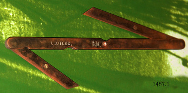
Tool - Bevel gauge, Mid-to-late 20th century
The double bevel gauge is used as a drawing tool, to measure, set angles and transfer angles. The shipwright’s tools on display in the Great Circle Gallery are connected to the maritime history of Victoria through their past owner, user and donor, Laurie Dilks. Laurie began his career as a shipwright in the mid-1900s, following in the wake of the skilled carpenters who have over many centuries used their craft to build and maintain marine vessels and their fittings. You can see Laurie’s inscription on the tool called a ‘bevel’. Laurie worked for Ports and Harbours, Melbourne, for over 50 years, beginning in the early 1960s. He and a fellow shipwright inscribed their names on a wheelhouse they built in 1965; the inscription was discovered many decades later during a repair of the plumbing. Many decades later Laurie worked on the Yarra moving barges up and down the river and was fondly given the title ‘Riverboat Man’ His interest in maritime history led him to volunteer with the Maritime Trust of Australia’s project to restore and preserve the historic WWII 1942 Corvette, the minesweeper HMAS Castlemaine, which is a sister ship to the HMAS Warrnambool J202. Laurie Dilks donated two handmade displays of some of his tools in the late 1970s to early-1980s. The varnished timber boards displayed the tools below together with brass plaques. During the upgrade of the Great Circle Gallery Laurie’s tools were transferred to the new display you see there today. He also donated tools to Queenscliffe Maritime Museum and Clunes Museum.The shipwright’s tools on display in the Great Circle Gallery are connected to the maritime history of Victoria through their past owner, user and donor, Laurie Dilks. Laurie began his career as a shipwright at Ports and Harbours in Melbourne in the mid-1900s, following in the wake of the skilled carpenters who have over many centuries used their craft to build and maintain marine vessels and their fittings.This double bevel gauge has three lengths of flat brass that swivel at the joints. The long piece has curved ends and indented arcs, one on each side, along the length. The short pieces have diagonal ends. The centre length has a hole through the middle. The short pieces have a screw with its head above the flat brass. The tool has an inscription. It once belonged to shipwright Laurie Dinks.Bevel marked "L DILKS" "G. M."flagstaff hill, warrnambool, great ocean road, shipwreck coast, maritime museum, maritime village, shipwright, carpenter, shipbuilding, ship repairs, hand tool, equipment, ship maintenance, cooper, tool, marine technology, bevel, drawing tool, measuring tool, laurie dilks, l dilks, port and harbours melbourne -
 Flagstaff Hill Maritime Museum and Village
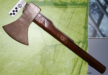
Tool - Broad axe, mid-to-late 20th century
A broad axe is used for the initial cutting and shaping of a log to prepare it for the piece to be made. The shipwright’s tools on display in the Great Circle Gallery are connected to the maritime history of Victoria through their past owner, user and donor, Laurie Dilks. Laurie began his career as a shipwright in the mid-1900s, following in the wake of the skilled carpenters who have over many centuries used their craft to build and maintain marine vessels and their fittings. You can see Laurie’s inscription on the tool called a ‘bevel’. Laurie worked for Ports and Harbours, Melbourne, for over 50 years, beginning in the early 1960s. He and a fellow shipwright inscribed their names on a wheelhouse they built in 1965; the inscription was discovered many decades later during a repair of the plumbing. Many decades later Laurie worked on the Yarra moving barges up and down the river and was fondly given the title ‘Riverboat Man’ His interest in maritime history led him to volunteer with the Maritime Trust of Australia’s project to restore and preserve the historic WWII 1942 Corvette, the minesweeper HMAS Castlemaine, which is a sister ship to the HMAS Warrnambool J202. Laurie Dilks donated two handmade displays of some of his tools in the late 1970s to early-1980s. The varnished timber boards displayed the tools below together with brass plaques. During the upgrade of the Great Circle Gallery Laurie’s tools were transferred to the new display you see there today. He also donated tools to Queenscliffe Maritime Museum and Clunes Museum.The shipwright’s tools on display in the Great Circle Gallery are connected to the maritime history of Victoria through their past owner, user and donor, Laurie Dilks. Laurie began his career as a shipwright at Ports and Harbours in Melbourne in the mid-1900s, following in the wake of the skilled carpenters who have over many centuries used their craft to build and maintain marine vessels and their fittings.Broad axe; a wooden handle with a round metal wedge-shaped head, reinforced with a metal plate on at the back of the handle. There is a hole in the handle about halfway along its length. It once belonged to shipwright Laurie Dinks.flagstaff hill, maritime museum, maritime village, warrnambool, shipwreck coast, great ocean road, shipwright, carpenter, shipbuilding, ship repairs, hand tool, equipment, caulking, ship maintenance, cooper, shipwright’s tools, shipwrights’ tools, tools, maritime trade, broad axe, caulking iron, laurie dilks, l dilks, port and harbours melbourne