Showing 3404 items matching " 2000.522..01"
-
 Yarrawonga RSL Sub Branch
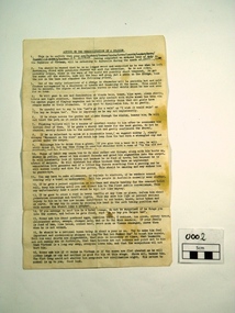
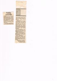
Document, Untitled et al, Advice on the rehabilitation of a soldier, 01/09/1970
This item is from the Vietnam war era. It was created as light relief for families of veterans due to return home from overseasThis document shows the larrican attitude of Australian soldiers ready to return home from hazadous overseas service.An A4 document from the Vietnam era giving a humourous angle on how to rehabilitate a Vietnam veteran guided at the family of the veteran. It has paragraphs numbered 1 to 16vietnam, document -
 Bendigo Historical Society Inc.
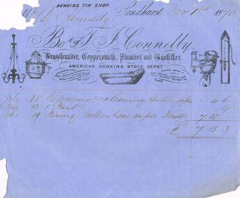
Document - THOMAS JAMES CONNELLY COLLECTION: INVOICE 1 NOV 1870, 01/11/1870
The Thomas James Connelly collection. T. J. Connelly - Brassfounder, Coppersmith, Plumber and Gasfitter. Located in High St. Bendigo. Items of correspondence. Official business invoice, on blue paper, for Mr D. Kennedy, dated Nov 1st, 1870. Bendigo Tin Shop printed across the top.trades, plumbing, thomas james connelly, connelly, thomas james. plumbers. bendigo tin shop. -
 Bendigo Historical Society Inc.
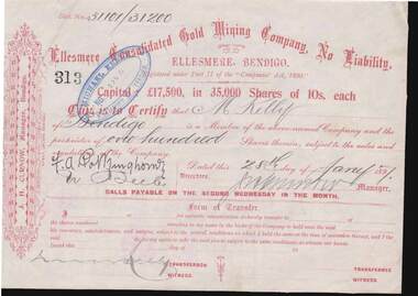
Document - KELLY AND ALLSOP COLLECTION: SHARE CERTIFICATE - CONSOLIDATED GOLD MINING COMPANY, 28/01/1897
Document. KELLY & ALLSOP COLLECTION. One share certificate issued by the Consolidated Gold Mining Company, Ellesmere, Bendigo, representing 100 shares at 10 shillings each. Capital raised was 17,500 Pounds from 35,000 shares. Certificate No. 313 issued to M.Kelly on 28 Jan 1897. Signed by J.H.Curnow, Manager.Consolidated Gold Mining Co.business, stockbroker, kelly & allsop, kelly & allsop collection, share certificate, ellesmere, consolidated gold mining co., m.kelly, j.h.curnow -
 Bendigo Historical Society Inc.
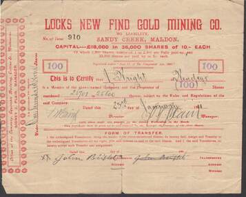
Document - KELLY AND ALLSOP COLLECTION: SHARE CERTIFICATE - LOCKS NEW FIND GOLD MINING CO, 23/01/1911
Document. KELLY & ALLSOP COLLECTION. One Share Certificate issued by Locks New Find Gold Mining Co., Sandy Creek, Maldon, representing 100 shares at 10 shillings each. Capital raised was 18,000 Pounds from 36,000 shares. Certificate No. 910 issued to J.Bright of Bendigo on 23 Jan 1911. Certificate signed by Sidney J.Plain, Manager.Locks New Find Gold Mining Co.business, stockbroker, kelly & allsop, kelly & allsop collection, locks new find gold mining co., maldon, share certificate, j. bright, sidney j.plain -
 Bendigo Historical Society Inc.
Newspaper - THREE UNRELATED ADVERTISER ARTICLES: SIMES (SYMES?) FAMILY: GOLDEN SQUARE RAILWAY STATION: ONE TREE HILL, 01/09/1984
Three unrelated Advertiser articles all dated 1/9/1984 stapled together- Simes (Symes?)family; Golden Square railway station; One Tree Hill. Simes family: Letter asking for help in assistance with information about the Simes family (1905-1924); Golden Square (railway) station buildings - some history of the building but article is about dilemma of old and 'not needed' buildings ''I wonder whether anybody want Golden Square/'' author - Andrew Ward, Bendigo Advertiser; article by John Hattam re the origin of the name ''One Tree Hill'' and history of the cutting down of The Tree (1879 - prosecution of a Jerry Ryan for vandalism); the road to the top being constructed (1892); lookout-tower constructions - the first being in 1894.document, newspaper, old rail stations, golden square rail station -
 Bendigo Historical Society Inc.
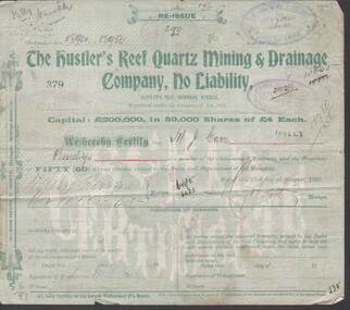
Document - KELLY AND ALLSOP COLLECTION: SHARE CERTIFICATES - HUSTLER'S REEF, IRONBARK, BENDIGO, 23/08/1902 to 25/01/1904
Documents. KELLY & ALLSOP COLLECTION. A series of Share Certificates issued by The Hustler's Reef Quartz Mining & Drainage Company, No Liability. Each certificate represents 50 shares at 4 pounds each. Capital raised was 200 thousand pounds from 50,000 shares. Certificates No.379, 384 issued to M.J.Carr on 23 Aug 1902. Certificate No.400 issued to G.H.Pearce on 23 Aug 1902. Certificates No.1427 - 1433 issued to N.Lloyd on 28 Oct 1902. Certificates No. 2259 - 2265 issued to C.Millman on 10 Aug 1903. Certificates No.2714, 2715 issued to N.Lloyd on 25 Jan 1904. Each certificate is pale green in colour and has a plan of the mine on the back. Printed by J.B.Young, Bendigo. Certificates dated 1902 are signed by the Manager Henry Y North and later certificates signed by G Stanfield for the Manager. 19 certificates in total.Hustler's Reef Minebusiness, stockbroker, kelly & allsop, kelly & allsop collection, hustlers reef mine, share certificates, henry y.north, g.stanfield, m.j.carr, g.h.pearce, n.lloyd, c.millman -
 Bendigo Historical Society Inc.
Document - KELLY AND ALLSOP COLLECTION: BENDIGO STOCK EXCHANGE PRICE LIST, 01/10/1908 to 16/10/1908
Document. KELLY & ALLSOP COLLECTION. Two single sided printed sheets headed 'Bendigo Stock Exchange Price List'. Some 170 Mining Companies listed with provision to write in buyer, seller and sales data for morning, noon, afternoon and 5pm prices. One sheet (a) is dated 1 Oct 1908 and the other (b) 16 Oct 1908. Only a few prices have been handwritten on each sheet. Signature of M.R.Kelly on top LH side of each sheet.Bendigo Stock Exchangebusiness, stockbroker, kelly & allsop, kelly & allsop collection, bendigo stock exchange, price list, mining companies. -
Moorabbin Air Museum
Booklet (Item) - CAC Wirraway: Local Warplane Production, Wirraway No.1 Local Warplane Production, 01/05/1939
The magazine article features information about the formation of the CAC and early production of the Wirraway aircraft. -
Moorabbin Air Museum
Book (item) - CAC Collection - Wirraway Air Frame Log Book A20-115, Royal Australian Air Force et al, 01/10/1940
Also contains the maintenance logbook for a de Havilland propeller used on A20-115. Maintenance mostly carried out at 23 Squadron -
 National Vietnam Veterans Museum (NVVM)
Booklet, Infantry Training Volume 1, 01/03/1968 (Exact)
A book with light blue cover about infantry training vol. 1 binded by two small metel screwsInfantry training volume 1. Pamphlet no 12. Theory of small arm fire and training the battle shot (All arms) 1967training document -
 Wangaratta Historical Society
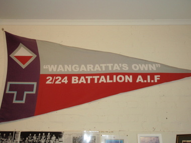
2nd 24th Battalion Wangaratta's Own, 01/07/1940
"Wangaratta's Own", the 2nd 24th Battalion was formed in Wangaratta on 1st July 1940, during World War Two. They camped at the Wangaratta Showgrounds, where they trained until they marched out of Wangaratta on 28th September 1940. Before they marched out Alan MacFarlane and the Battalion were presented with the Battalion pennant by Wangaratta Mayor, Cr Thomas Nolan. They fought in . On 28th September 1990, the 50th anniversary of the Battalion leaving Wangaratta, (retired) Alan MacFarlane, President of the 2nd 24th Battalion Association were presented the Freedom of the City and represented with the Battalion pennant by Wangaratta Mayor, Cr Kevin Gleeson & Cr Val Gleeson, Cr Thomas Nolan's son in law & daughter. This was an Army Battalion formed in Wangaratta. The young men interacted with the businesses, sporting & social societies & families of Wangaratta in the early 1940's. Lifelong friendships were made."Wangaratta's Own", the 2nd 24th Battalion was formed in Wangaratta on 1st July 1940, during World War Two. They camped at the Wangaratta Showgrounds, where they trained until they marched out of Wangaratta on 28th September 1940. Before they marched out Alan MacFarlane and the Battalion were presented with the Battalion pennant by Wangaratta Mayor, Cr Thomas Nolan. They fought in . On 28th September 1990, the 50th anniversary of the Battalion leaving Wangaratta, (retired) Alan MacFarlane, President of the 2nd 24th Battalion Association were presented the Freedom of the City and represented with the Battalion pennant by Wangaratta Mayor, Cr Kevin Gleeson & Cr Val Gleeson, Cr Thomas Nolan's son in law & daughter. army battalion wangaratta's own world war two -
Moorabbin Air Museum
Document (item) - CAC Wirraway Overhaul Manual, COMMONWEALTH AIRCRAFT CORPORATION PTY LTD, The "Wirraway" Overhaul and Repair Manual, 01/11/40
RAAF Publication No 76 -
Moorabbin Air Museum
Document (item) - CAC STI Wirraway RAAF Special Technical Instructions, COMMONWEALTH AIRCRAFT CORPORATION PTY LTD, S.T.I. Wirraway, 01/07/1958
-
Moorabbin Air Museum
Book (Item) - Pratt & Whitney Wasp Engine Logbook for Wirraways, COMMONWEALTH AIRCRAFT CORPORATION PTY LTD et al, Aero-Engine Log Book, WASP, Mark No. S1-H1-G, Maker's Number 486, Installed in Wirraway A20-570, A20-444 & A20-230, 01/04/42
Maintenance work carried out mostly by 5 Service Flight Training School. -
 St Kilda Historical Society
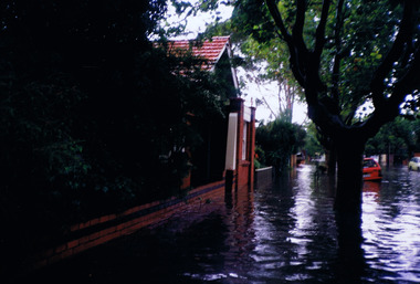
Photograph, St Kilda floods, 23 January 1991 - images collection, 23/01/1991
Heavy rains caused flooding in the Port Phillip area on 23 January 1991, including in St Kilda. The level of Elster Creek, Elsternwick, rose to 2.54m (from normal level of 0.1m) and there was historically high flooding along Elwood CanalColour photographFlood 23/1/91 9.30amst kilda, flood 1991, 23 january 1991, 23/01/91 -
 St Kilda Historical Society
Photograph - Photo map, 28/01/1951
One of a series of photo-maps produced for the Department of Crown Lands and Survey (1857-1983). For correlation with a current map, and access to other historical photo maps of Victoria, see the Historic Photo-Maps Index published by the Department of Environment, Land, Water and Planning at https://services.land.vic.gov.au/DELWPmaps/historical-photomaps/Black and white aerial photograph1424-45 SECRET 534 Run 18 Lens 12" Melbourne Metropolitan 12150 28.1.51 M639albert park, st kilda junction, st kilda pier, catani gardens, st kilda, prahran, albert park lake, 1951, middle park, st kilda beach, windsor -
 St Kilda Historical Society
Photograph - Photo map, 17/01/1951
One of a series of photo-maps produced for the Department of Crown Lands and Survey (1857-1983). For correlation with a current map, and access to other historical photo maps of Victoria, see the Historic Photo-Maps Index published by the Department of Environment, Land, Water and Planning at https://services.land.vic.gov.au/DELWPmaps/historical-photomaps/Black and white aerial photograph1414-21 538 Run 19 Lens 12" Melbourne Metropolitan 12150 17.1.51 M586st kilda, st kilda botanical gardens, peanut farm, elwood, 1951, point ormond, elwood canal, st kilda beach -
 St Kilda Historical Society
Photograph - Photo map, 28/01/1951
One of a series of photo-maps produced for the Department of Crown Lands and Survey (1857-1983). For correlation with a current map, and access to other historical photo maps of Victoria, see the Historic Photo-Maps Index published by the Department of Environment, Land, Water and Planning at https://services.land.vic.gov.au/DELWPmaps/historical-photomaps/Black and white aerial photograph1424-118 534 Run 20 Lens 12" Melbourne Metropolitan 12150 18.1.51M639elwood, point ormond, elwood park, elsternwick park, elwood beach, 1951 -
 St Kilda Historical Society
Photograph - Photo map, 17/01/1951
One of a series of photo-maps produced for the Department of Crown Lands and Survey (1857-1983). For correlation with a current map, and access to other historical photo maps of Victoria, see the Historic Photo-Maps Index published by the Department of Environment, Land, Water and Planning at https://services.land.vic.gov.au/DELWPmaps/historical-photomaps/Black and white aerial photograph1414-20 538 Run 19 Lens 12" Melbourne Metropolitan 12150 17.1.51 M586elwood, elsternwick, st kilda east, balaclava, ripponlea, 1951 -
 St Kilda Historical Society
Photograph - Photo map, 28/01/1951
One of a series of photo-maps produced for the Department of Crown Lands and Survey (1857-1983). For correlation with a current map, and access to other historical photo maps of Victoria, see the Historic Photo-Maps Index published by the Department of Environment, Land, Water and Planning at https://services.land.vic.gov.au/DELWPmaps/historical-photomaps/Black and white aerial photograph1424-44 534 Run 18 Lens 12" Melbourne Metropolitan 12150 28.1.51 M639 -
 St Kilda Historical Society
Photograph - Photo map, 28/01/1951
One of a series of photo-maps produced for the Department of Crown Lands and Survey (1857-1983). For correlation with a current map, and access to other historical photo maps of Victoria, see the Historic Photo-Maps Index published by the Department of Environment, Land, Water and Planning at https://services.land.vic.gov.au/DELWPmaps/historical-photomaps/Black and white aerial photograph1424-43 534 Run 18 Lens 12" Melbourne Metropolitan 12150 28.1.51 M639armadale, malvern, st kilda cemetery, caulfield north, st kilda east, 1951 -
 St Kilda Historical Society
Photograph - Photo map, 30/01/1960
One of a series of photo-maps produced for the Department of Crown Lands and Survey (1857-1983). For correlation with a current map, and access to other historical photo maps of Victoria, see the Historic Photo-Maps Index published by the Department of Environment, Land, Water and Planning at https://services.land.vic.gov.au/DELWPmaps/historical-photomaps/Black and white aerial photographVic 1093-62 Melbourne & Metropolitan Project Run 21 30.1.60 Lens 10" 8.200middle park, albert park, catani gardens, st kilda west, 1960 -
 St Kilda Historical Society
Photograph - Photo map, 30/01/1960
One of a series of photo-maps produced for the Department of Crown Lands and Survey (1857-1983). For correlation with a current map, and access to other historical photo maps of Victoria, see the Historic Photo-Maps Index published by the Department of Environment, Land, Water and Planning at https://services.land.vic.gov.au/DELWPmaps/historical-photomaps/Black and white aerial photographVic 1093-60 Melbourne & Metropolitan Project Run 21 30.1.60 Lens 10" 8.200st kilda, albert park, prahran, windsor, south yarra, 1960 -
 St Kilda Historical Society
Photograph - Photo map, 30/01/1960
One of a series of photo-maps produced for the Department of Crown Lands and Survey (1857-1983). For correlation with a current map, and access to other historical photo maps of Victoria, see the Historic Photo-Maps Index published by the Department of Environment, Land, Water and Planning at https://services.land.vic.gov.au/DELWPmaps/historical-photomaps/Black and white aerial photographVic 1092-36 Melbourne & Metropolitan Project Run 22 30.1.60 Lens 10" 8.200st kilda, st kilda pier, st kilda beach, catani gardens, 1960 -
 St Kilda Historical Society
Photograph - Photo map, 30/01/1960
One of a series of photo-maps produced for the Department of Crown Lands and Survey (1857-1983). For correlation with a current map, and access to other historical photo maps of Victoria, see the Historic Photo-Maps Index published by the Department of Environment, Land, Water and Planning at https://services.land.vic.gov.au/DELWPmaps/historical-photomaps/Black and white aerial photographVic 1092-38 Melbourne & Metropolitan Project Run 22 30.1.60 Lens 10" 8.200st kilda, st kilda beach, st kilda pier, catani gardens, 1960, st kilda botanical gardens, peanut farm -
 St Kilda Historical Society
Photograph - Photo map, 30/01/1960
One of a series of photo-maps produced for the Department of Crown Lands and Survey (1857-1983). For correlation with a current map, and access to other historical photo maps of Victoria, see the Historic Photo-Maps Index published by the Department of Environment, Land, Water and Planning at https://services.land.vic.gov.au/DELWPmaps/historical-photomaps/Black and white aerial photographVic 1092-40 Melbourne & Metropolitan Project Run 22 30.1.60 Lens 10" 8.200st kilda east, balaclava, ripponlea, st kilda cemetery, 1960 -
 St Kilda Historical Society
Photograph - Photo map, 30/01/1960
One of a series of photo-maps produced for the Department of Crown Lands and Survey (1857-1983). For correlation with a current map, and access to other historical photo maps of Victoria, see the Historic Photo-Maps Index published by the Department of Environment, Land, Water and Planning at https://services.land.vic.gov.au/DELWPmaps/historical-photomaps/Black and white aerial photographVic 1092-42 Melbourne & Metropolitan Project Run 22 30.1.60 Lens 10" 8.200malvern, caulfield, caulfield park, 1960 -
 St Kilda Historical Society
Photograph - Photo map, 30/01/1960
One of a series of photo-maps produced for the Department of Crown Lands and Survey (1857-1983). For correlation with a current map, and access to other historical photo maps of Victoria, see the Historic Photo-Maps Index published by the Department of Environment, Land, Water and Planning at https://services.land.vic.gov.au/DELWPmaps/historical-photomaps/Black and white aerial photographVic 1091-112 Melbourne & Metropolitan Project Run 23East 30.1.1960 Lens 10" 8.200elwood, point ormond, elwood park, elwood canal, 1960 -
 St Kilda Historical Society
Photograph - Photo map, 30/01/1960
One of a series of photo-maps produced for the Department of Crown Lands and Survey (1857-1983). For correlation with a current map, and access to other historical photo maps of Victoria, see the Historic Photo-Maps Index published by the Department of Environment, Land, Water and Planning at https://services.land.vic.gov.au/DELWPmaps/historical-photomaps/Black and white aerial photographVic 1091-110 Melbourne & Metropolitan Project Run 23East 30.1.60 Lens 10" 8.200elwood, elsternwick, elsternwick park, ripponlea, st kilda east, caulfield, balaclava, 1960 -
 St Kilda Historical Society
Photograph - Photo map, 30/01/1960
One of a series of photo-maps produced for the Department of Crown Lands and Survey (1857-1983). For correlation with a current map, and access to other historical photo maps of Victoria, see the Historic Photo-Maps Index published by the Department of Environment, Land, Water and Planning at https://services.land.vic.gov.au/DELWPmaps/historical-photomaps/Black and white aerial photographVic 1091-1 Melbourne & Metropolitan Project Run 24East 30.1.60 Lens 10" 8.200elwood, elwood beach, elwood park, 1960