Showing 9778 items
matching east street
-
 Orbost & District Historical Society
display cabinet and tools
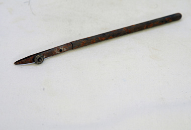
This display was put together by the Curlip Committee and used as promotion in the shed during the construction of Curlip 11 A community project, this boat was constructed out of local hardwood timbers utilizing the traditional skills of wooden boat builders and is powered by a steam engine. Paddle Steamer Curlip II is a replica of an historic paddle steamer of the Snowy River, in Far East Gippsland, Victoria. The original Paddle Steamer Curlip was built by Sam Richardson and his sons Mark, Albert and Frank, at their sawmill at Tabbara, a pioneering settlement on the Brodribb River, a tributary of the Snowy River. The keel was laid on 14th October 1889 and PS Curlip was launched in 1890. The name “ Curlip” is derived from the indigenous name for the area where Tabbara is located and includes land to the east of the Snowy and Brodribb Rivers towards Cape Conran. PS Curlip was registered in 1893 and the Passenger Certificate issued on 30th January 1903 to Captain Alan Richardson by the Marine Board of Victoria entitled her to carry 25 passengers and only 10 passengers when engaged in towage service. Two children under 12 years of age to be reckoned as one passenger. PS Curlip towed five barges at a time, traveling upstream as far as Bete Bolong, 20 km upstream of the mouth to collect produce to be transferred to schooners near Marlo. She towed vessels in and out through the Snowy river entrance and was also used for social functions such as Sunday School picnics. She was the main means of transport for imports and exports on the Snowy River for almost 30 years. The Curlip era ended abruptly on Friday 28th February when a flash flood carried her and 2 barges down river and out to sea, where she washed ashore at Marlo and broke up.More than eighty years after the original Paddle Steamer Curlip was wrecked at sea, the Orbost community launched a replica which it hoped would draw tourists to the region. The P.S. Curlip II, is based on drawings of the original Curlip that made its home in the Snowy and Brodribb Rivers of East Gippsland in the 1890s and early 1900s, It took six years of planning and hundreds of hours of volunteer work from the local community.A display cabinet containing tools and sundry items related to the Paddle Steamer Curlip. (More information on individual items in Catalogue 1400-1600)p.s.curlip richardson-samuel boat-building-tools transport -
 Orbost & District Historical Society
framed certificate, January 2003
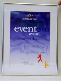
This certificate was presented at the East Gippsland Shire Council Australia Day celebrations on 26.1.2003. The veiling of McKillops bridge was a 'Year of the Outback' event. The event was organised by Orbost resident, Sr Helen Barnes RSJ. to show solidarity with rural people. The local community transformed the bridge into "a symbol of communal love and hope", when its sides were draped with hundreds of personal messages. McKillop's Bridge, located high in the Snowy Mountains, is named after George McKillop, a pioneering explorer of the area. The bridge is a vital link for isolated farming communities living beyond the Bonang highway. The Veiling of McKillops Bridge was a significant community event.A large framed certificate. An Australia Day Community Event certificate for January 2003. The frame is silver The certificate has white, green and blue print on a blue background.presented to "Veiling of McKillops Bridge on frame corner AMS by East Gippsland Shie Council signed by Cr P. Bommer (mayor)mckillops-bridge-veiling east-gippsland-shire-council-australia-day -
 Orbost & District Historical Society
souvenir glass, 1994
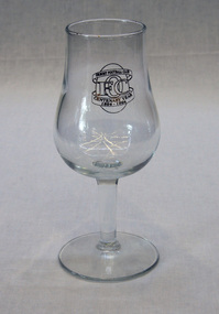
This souvenir wine glass was made for celebration of the centenary of the Orbost Football Club in 1994. The Orbost football club players were known as the Busters and wore green and gold guernseys. An Orbost football team has participated in the East Gippsland League since the early 20th century. In 2003 in response to a dwindling population, the Snowy Rovers and Orbost Football Clubs were driven to merge into the Orbost Snowy RoversOrbost Football Club through its many changes has always been an important social fabric of the Orbost community. Sport is often regarded as an important part of life in rural Australia, contributing to community identity, sense of place, social interaction and good health. A clear wine glass produced for the centenary of the Orbost Football Club -1894-1994. On an oval (representing a football) is O F C with "ORBOST FOOTBALL CLUB" in a banner above and "CENTENARY YEAR 1894 -1994" in a banner below. all written in gold. On an oval (representing a football) is O F C with "ORBOST FOOTBALL CLUB" in a banner above and "CENTENARY YEAR 1894 -1994" in a banner below. all written in gold.souvenir wine-glass orbost-football-club -
 Orbost & District Historical Society
cutlery, 1880's
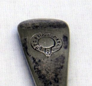
RIDGE PARK, Length: 65.2 m.; Owned by H. Simpson & Sons; Built at S. P. Austin & Sons in 1878. Registered at Adelaide. On 10 February 1881, RIDGE PARK (Capt. Heslop) was on voyage from Adelaide to Sydney with a cargo of brandy, wine and flour, when she was lost after running aground.Beware Reef is located south east of Cape Conran in east Gippsland.This cutlery is from the Ridge Park which, on 10 February 1881, was wrecked on Beware Reef , just south of Cape Conran in east Gippsland.Two forks and two spoon which are silver plated dinner cutlery.On front of handles - S.S.Ridge Park On back of handles - EP & NS with an A inside a circle -
 Ringwood and District Historical Society
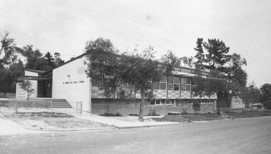
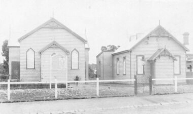
Photograph, Saint Francis De Sales church and school, corner Patterson Street and Bona Avenue, Ringwood East - 1973
Typed below photograph, "Roman Catholic Church and School, Ringwood East, 1973". -
 Ringwood and District Historical Society
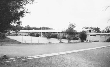
Photograph, Heathmont East State School, Cnr Armstrong Road & Louis Street, Heathmont - 1973
Typed below photograph, "Heathmont East State School - 1973". -
 Ringwood and District Historical Society
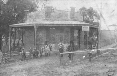
Photograph, Maroondah Highway East, Ringwood- 1914. Mr. O.J. Pratt's butcher shop under construction, cnr Main Street and Warrandyte Road
Black and white photograph (2 copies)Typed below photograph: "Mr. O.J. Pratt's butcher shop being constructed corner Warrandyte Rd. and Main St. (Demolished for road widening) 1914. Site became C.B.C. Bank. -
 Ringwood and District Historical Society
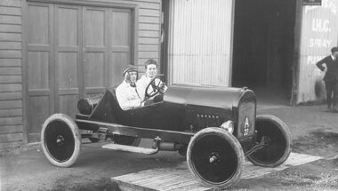
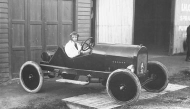
Photograph, Maroondah Highway East, Ringwood- 1925. L. Little and E. O'Keefe's racing car outside their garage in Whitehorse Road near Pratt Street
Black and white photograph (2 copies)Typed below one photograph, "Little and O'Keefe's racing car outside their garage in Whitehorse Rd. near Coffeys - 1925". Written on rear of backing sheet: "L. Little & E. O'keefe. Little ran the pictures in the Mechanics Institute." -
 Ringwood and District Historical Society
Photograph, Maroondah Highway East, Ringwood- 1925. L. Little and E. O'Keefe's racing car outside their garage near Pratt Street
Black and white photographWritten on backing sheet: "E O'Keefe in home made racing car outside garage near Coffey's, 1925." -
 Ringwood and District Historical Society
Photograph, Maroondah Highway East, Ringwood- c.1930's. H. F. Richards' Garage, cnr Whitehorse Road and Pratt Street
Black and white photograph (2 copies)Written on rear of backing sheet: "H. J. Richards garage - corner Whitehorse Rd. and Pratt St. Ringwood." -
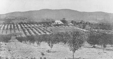
 Ringwood and District Historical Society
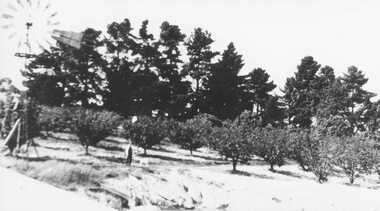
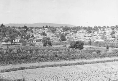
Photograph, H.E. Watson's orchard- Ringwood East. c1900's
Black and white photographWritten on backing sheet- "H. E. Watson's Orchard. Ringwood East." Included with image is a copy of early street map showing location of orchard on corner of Old Lillydale Road and Maroondah Highway.agriculture -
 Ringwood and District Historical Society
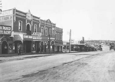
Photograph, Maroondah Highway Central, Ringwood. Main Street shops looking east from near station entrance, c1921
... Maroondah Highway Central, Ringwood. Main Street shops... Street Shops". Black and white photograph(2 copies- 1 large, 1 ...Black and white photograph(2 copies- 1 large, 1 smaller)Written below photograph, "Main Street Shops". -
 Ringwood and District Historical Society
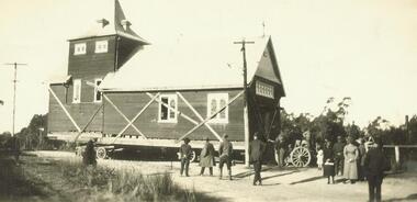
Photograph, Relocation of Ringwood Church of England building from Maroondah Hwy & Pratt Street corner to Ringwood Street - c.1924
Removing Church of England Church building from Ringwood East to near Post OfficeWritten on front of photograph, "Removing C. of E. from Ringwood East to near P. Office" -
 Ringwood and District Historical Society
Photograph, Main Street shops looking east - Maroondah Hwy, Ringwood - 1935
... Main Street shops looking east - Maroondah Hwy, Ringwood..., "Main Street, Ringwood". Main Street shops looking east ...Written on back of photograph, "Main Street, Ringwood". -
 Ringwood and District Historical Society
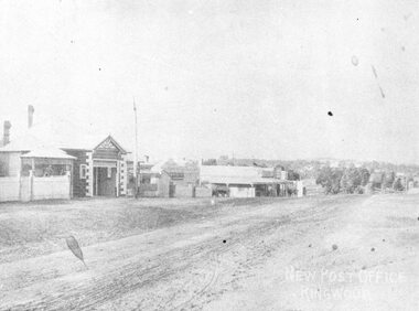
Photograph, Maroondah Highway Central, Ringwood. Looking east from opposite station entrance, c.1910
Black and white photograph (2 copies) Typed below photograph: "Maroondah Hwy. looking east from opposite the station entrance towards Warrandyte Rd, showing the new post office (our second) on the left. No telephones then and no poles and wires in the street. c1900 - 1910". -
 Ringwood and District Historical Society
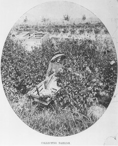
Photograph, Collecting Dahlias - Mr. Hill's Flower Farm - Mt. Dandenong Rd, Ringwood 1905
Black and white photograph (4 copies)Typed note at bottom of one photograph- "Mr. Hill's Flower Farm - Mt. Dandenong Rd. Miss Hill collecting dahlias. 1905." Typed note on back of separate photograph- "John Hill's flower farm 29/3/05, Mt Dandenong Rd, Ringwood East. Later Howship's flower farm, subdivided, name retained in street name. Miss Elvie Hill. -
 Ringwood and District Historical Society
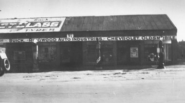
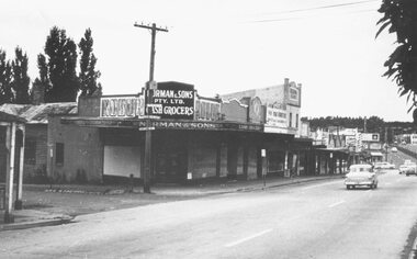
Photograph, Maroondah Highway Central, Ringwood. Corner Main Street & Adelaide St. looking east towards Warrandyte Road- 1966
... Maroondah Highway Central, Ringwood. Corner Main Street...Typed below one copy: "Corner Main Street & Adelaide St... Main Street & Adelaide St. looking east towards Warrandyte Road ...History of the Norman Cash Grocery Stores. Normans started grocery store in Drummond Street Oakleigh in 1903 and expanded to 13 stores in adjacent suburbs, Ringwood being one of these. Photo is Norman & Sons P/L corner of Maroondah Highway and Adelaide Street.Black and white photograph (2 copies) Typed below one copy: "Corner Main Street & Adelaide St. looking east towards Warrandyte Road - 1966". Image shows Norman & Sons Grocer store on corner of Adelaide Street and Main Street. -
 Ringwood and District Historical Society
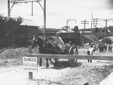
Photograph, Construction of railway viaduct in Pitt Street, Ringwood - circa 1923, south side looking east
Black and White photograph of horse and dray at construction siteType below one copy: Making Warrandyte Rd Subway, 1923 Taken from Pitt St. -
 Ringwood and District Historical Society
Photograph, Ringwood Methodist Church on site at Cnr. Melbourne St. and Whitehorse Rd 1904
Written on backing sheet, "Methodist Church on site at Cnr. Melbourne St. and Whitehorse Rd. On its removal to Greenwood Ave. Mr. J.B. McAlpin built shops on this site - land (Dimmey's) including his own estate agency." One photograph claimed church was moved to Greenwood Ave in 1916. Photograph taken in 1904. Another photograph states that the photograph is of the Methodist Church and Sunday School. Inserted in the sleeve of one of the photographs are two small postcard photographs that state they are, "Methodist Church in Main Street, Ringwood opposite railway station. See Mechanics Institute where Town Hall now stands - c1910. Photo by L. F. East". -
 Ringwood and District Historical Society
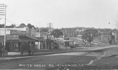
Photograph, Maroondah Highway Central, Ringwood. Whitehorse Rd. looking East from Adelaide St- 1918
Black and white photograph (3 copies- 2 large, 1 small postcard) Typed below one large photograph, "Whitehorse Rd. Looking east from Adelaide St. 1918". Image shows Falconer Grocer and Baker store on corner of Adelaide Street. -
 Ringwood and District Historical Society
Photograph, New housing developments, New Street, 1960 viewed from railway line near Madden Street looking south-east
... railway line near Madden Street looking south-east.... Street, 1960. From railway line near Madden Street looking south... near Madden Street looking south-east. Dam centre foreground ...Written on back of photograph, "New housing settlement New Street, 1960. From railway line near Madden Street looking south-east. Dam centre foreground". -
 Ringwood and District Historical Society
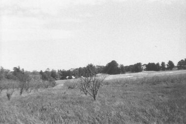
Photograph, Looking across remains of Frazer's orchard to state school, 1972
Updated Information from Bruce Frazer: This is Frazer's (not "Fraser") orchard, sold to A.V. Jennings Co. For housing development c1970. Address was "Alkoomi", Oban Rd. North Ringwood. State School 4120 was enclosed on its north & east sides by the orchard. Owned by Harold & Sylvia Frazer, 12 acres, growing mainly cherries plus plums & lemons. Photo was taken from neighbouring apple orchard (Williams) & shows street construction in the middle distance.Written on back of photograph, "Looking across remains of Fraser's orchard to state school, 1972". -
 Ringwood and District Historical Society
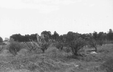
Photograph, Remains of Frazer's orchard, North Ringwood. State school on left - 1972
Updated Information from Bruce Frazer: This is Frazer's (not "Fraser") orchard, sold to A.V. Jennings Co. For housing development c1970. Address was "Alkoomi", Oban Rd. North Ringwood. State School 4120 was enclosed on its north & east sides by the orchard. Owned by Harold & Sylvia Frazer, 12 acres, growing mainly cherries plus plums & lemons. Photo was taken from neighbouring apple orchard (Williams) & shows street construction in the middle distance.Written on back of photograph, "Remains of [Fraser's] orchard. State school on left". -
 Ringwood and District Historical Society
Photograph, Looking east from Loughnan Road across William & Andrew Streets c.1946
... across William & Andrew Streets 1946 Looking east from Loughnan ...Looking east from Loughnan Road across William & Andrew Streets 1946 -
 Ringwood and District Historical Society
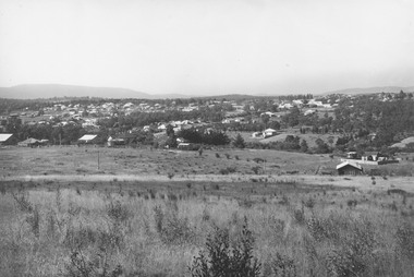
Photograph, View from Canterbury Road/Balfour Avenue area overlooking Martell's orchard, Heathmont, 1929
Black and white photograph of orchard. House in middle range, mountains in background. Photograph appears to be reproduced from subdivisional brochure. Note inserted in sleeve reads, "It has been pointed out that the mountains are to the east and the view is looking south. This therefore is not a 'straight' photograph. House still exists in Eden Avenue at October, 1996".(3 copies).Typed below photograph, "Panoramic view taken on the estate". "View overlooking Martell's orchard, Heathmont, 1929". Taken from corner Canterbury Rd. and Balfour Ave. looking south. Dandenong Creek just beyond house. Washusen Rd. on right". Written on back of one of the copies, "Heathmont Station Estate 1922". "Station Street, Lisgoold St. Canterbury Rd. Vivienne Cres. Balfour Ave." -
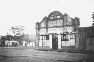 Ringwood and District Historical Society
Photograph, Adelaide Street, Ringwood, showing 'Mail' Office - looking east. Demolished for Eastland parking area. Photograph circa early 1960s
Catalogue card reads, "Adelaide St. showing 'Mail' Office - looking east. Demolished for Eastland parking area". -
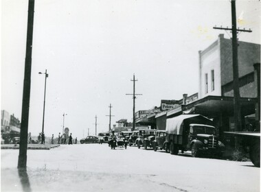 Ringwood and District Historical Society
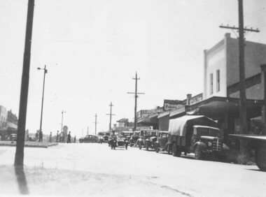
Photograph, Main Street Ringwood, looking east late 1940's
... Main Street Ringwood, looking east late 1940's..., not 1935, late 1940s?, 2 copies Main Street Ringwood, looking east ...Black and white photograph of Main Street, Ringwood. Clock tower in background in original position. (2 copies) Catalogue card reads, "Whitehorse Rd. looking east - south side 1935. Station entrance just past Carter's on right". Looking East from Whitehorse Rd, not 1935, late 1940s?, 2 copiesTyped below photograph, "Main St. Looking East. Railway Station entrance on right past Carter's - 1935". Small, original print has Main St c1949" written on back. -
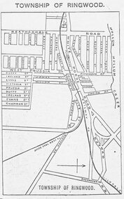 Ringwood and District Historical Society
Photograph, Directory of Ringwood Township, from Sands and McDougall Directory - 1905. (New Street is incorrectly shown as Heatherdale Road on this map. Heatherdale Road's actual location is to the east, beyond the top of the map perimeter.)
Catalogue card reads, 'Directory of Ringwood Township - 1905. From Sands and McDougall Directory.' -
 Ringwood and District Historical Society
Photograph, Maroondah Highway West, Ringwood- 1925. Outside the Ringwood Market
... photograph: "Maroondah Highway looking East towards cnr Ringwood... East towards cnr Ringwood Street and Wantirna Rd. Ringwood ...Black and white photograph (2 images MHW0025a and MHW0025b)Image MHW0025a: (2 copies) Typed under one photograph: "Outside the Ringwood Market in Maroondah Hwy, 1925. Shop in centre now SEC site at cnr Ringwood St. S.S.B. building still on site shown to left." Image MHW0025b: (2 copies) Typed under one photograph: "Maroondah Highway looking East towards cnr Ringwood Street and Wantirna Rd. Ringwood market in centre. -
 Orbost & District Historical Society
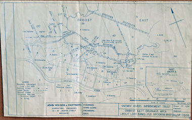
plan, December 1968
Brodribb floodplain regularly inundated in the late 1800s and early 1900s. Works included: clearing the river channel and blocking ‘gulches’. The meander was cut-off in 1931, as part of the Orbost East Drainage Scheme and further developed after 1934 floods and again in the early 1950s when levee banks and a regulator were constructed. (ref. East Gippsland Catchment Management)This is a useful reference tool.A hand-drawn plan of the layout of the levee banks of the Old Brodribb River.brodribb-river map plan-levee-banks