Showing 4552 items matching "historical map"
-
 Port Melbourne Historical & Preservation Society
Flyer, Suggested ring road around Port, 2018 - 2019
These items were collected by a PMHPS member during 2018-19 and they have been retained as a group of ephemeraVarious ephemera of local interest showing changes in community. . Flyer regarding proposed ring road around Port Melbourne. Map of proposed route and listing key contact people. Campaign by Social Media Realty.built environment, ring road, social media ready -
Port Melbourne Historical & Preservation Society
Map, Port Melbourne City Council, Port Melbourne - Our City, Our Life, Our Choice - No Amalgamation, Jun 1986
Port Melbourne - Our City, Our Life, Our Choice - No Amalgamation Map of area with names and addresses local government - city of port melbourne, amalgamation, frederick charles jackson, town clerks, liana thompson, mayors -
Port Melbourne Historical & Preservation Society
Map, Port Melbourne City Council, Port Melbourne - Our City, Our Life, Our Choice - No Amalgamation, Jun 1986
Port Melbourne - Our City, Our Life, Our Choice - No Amalgamation Proposal with City of Port Phillip map amalgamation, mayors, local government - city of port melbourne, local government - city of port phillip, liana thompson -
Port Melbourne Historical & Preservation Society
Document - Voters Rolls, District of Sandridge
Five (5) municipal electoral rolls(photocopies), District of Sandridge 1861; 1862; 1863; 1865; 1866 Photocopy of 1860 map, catalogue no 2083local government - borough of sandridge -
Port Melbourne Historical & Preservation Society
Document - Submissions, Barak Road and Beacon Road developments, 1972
22 stapled pages regarding Barak & Beacon Roads development. Submissions to Minister of Lands from Cr TURNER and Cr JULIER 1972. MMBW planning map. Fishermens Bend Productivity Group working committee notes. Drawings and plans for housing, notes on developments 1955 -1972built environment - public housing, built environment - domestic, local government - city of port melbourne, leslie stanley turner, raymond frank julier, perce mcguire white, perce white, w a borthwick -
Port Melbourne Historical & Preservation Society
Map - Navigation Charts, Port Melbourne, Williamstown and River Yarra, 1994
.01 - Navigation chart of Port Melbourne, Williamstown and River Yarra channels 1994. Chart No Aust 154 .02 - Navigation Chart of approaches to Melbourne. Chart No Aust 155 c1986sport - yachting, maritime, beacons -
Port Melbourne Historical & Preservation Society
Map - "The Township of Sandridge", Public Lands Office, 1859
Photocopy 1859 map of township of Sandridgelocal government - municipal district of sandridge, frank callaghan -
 Port Melbourne Historical & Preservation Society
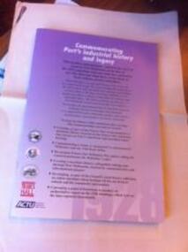
Booklet, Commemorating Port's Industrial History and Legacy, Feb 2011
Published to commemorate the anniversary of the 1928 waterfont lockout.Booklet with mauve background and black and white and dark red text. Back cover has map of "historic watersiders Port Melbourne walk"built environment, piers and wharves - princes pier, industrial disputes, allan whittaker, piers and wharves - waterside workers, maritime union of australia, mua, hogan's flat, beacon cove, james laurence murphy, george sangster -
 Port Melbourne Historical & Preservation Society
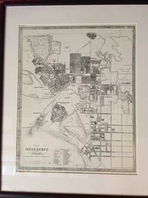
Map - Plan of Melbourne, 1855
Framed copy of 1855 "Plan of Melbourne and its suburbs". Black frame. Some writing can be seen on left hand side of print.built environment, melbourne and metropolitan board of works -
 Port Melbourne Historical & Preservation Society
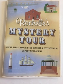
Pamphlet - Rochelle's Mystery Tour, bicycle tour of Port Melbourne identifying historic locations, Rochelle BELL, Rochelle's Mystery Tour, Jan 2017
Coloured 4 fold pamphlet with map, photographs of historic bike tour through Port Melbourne. Inside is large map marked with points of interest corresponding to photo and information on reverse sideRochelle's Mystery Tour a ride through the history and environment of Port Melbournebuilt environment, recreation, social activities, celebrations fetes and exhibitions, piers and wharves - princes pier, piers and wharves - station pier, rochelle bell, social health inclusion program (ship), danielle mccaffrey, centenary bridge, natural environment - beaches and foreshore, band rotunda, westgate park, lagoon reserve, liardet community centre, sandridge trugo club, garden city -
Port Melbourne Historical & Preservation Society
Book - Flannery Family History, Pros & Cons and Cops & Robbers, 2003
Pros & Cons and Cops & Robbers. Book of the Flannery Family history. Sepia and gold cover which is a map of "New Holland". Gold section has the name above words "Common men and women for an uncommon country". "A study through my ancestry by Robin Flannery with Frank Alcorta" Book inscribed on inside first page with names of the three Flannery girls and signed by the author. Latter part of book talks of family in Port Melbourne, including waterside workers, SP bookmaking and police.law, families, police, robin flannery, noelle kinsella, denise o'connor, rita may -
Port Melbourne Historical & Preservation Society
Map - Survey Map, Captain R Pasley R E, 24 Sep 1855
Survey map to accompany Colonial Engineers Report, September 1855melbourne -
Port Melbourne Historical & Preservation Society
Photograph - Woolsheds between Beacon and Barak Roads, Port Melbourne, Don Hossack, 1947
Donated by Don Hossack who took the photograph when he was 16 years old and working at the woolsheds. He recalls that bags of oats and barley were stored here.Photo (10 x 12" glossy black and white print) of the wool sheds between Beacon and Barak Roads. Shows north easternmost sheds and rail line. The wool sheds were built by the Americans during World War II and taken down again in the 1950s . Map (hand drawn) on rear shows location of photograph.map (hand drawn) of location of photographtransport - railways, built environment - industrial, war - world war ii -
Port Melbourne Historical & Preservation Society
Plan - Water cart used in road construction, Borough of Sandridge, 21 Nov 1870
From a group of maps and plans not required by the Port Melbourne Council Engineering Department in May 1994 and offered at that time to the Port Melbourne Historical Society.Plan of water cart used in road construction including 4 diagrams and scales: signed by Borough Surveyor, Nov 21 1870.built environment - civic, engineering, engineering department - borough of sandridge -
Port Melbourne Historical & Preservation Society
Plan - Sandridge, Department of Lands and Survey, "The Township of Sandridge", 5 Nov 1860
Map of Sandridge, lithographed 1860, showing subdivisions on Evans Street, but no other development West of the railway Lihographed at the Department of lands and Survey, Melbourne 5th November 1860. Hand drawn annotations added at unknown date.Hand written "clay ground" 18 chains long, 7.5 chains broad, 26 chains from railwayengineering - roads streets lanes and footpaths, sandridge lagoon, transport - railways, town planning, local government - borough of sandridge -
 Port Melbourne Historical & Preservation Society
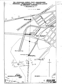
Map, Leading Lights of Port Melbourne Channel, 1926
Proposed arrangement of Leading Lights of mailboat channel at Port Melbourne piersbeacons, melbourne harbor trust - port of melbourne authority, leading lights -
Port Melbourne Historical & Preservation Society
Map - Route of US Navy Great White Fleet, 2008
Large photocopy of map of the world with the route of the Great White Fleet (US Navy) 1908 marked in red and white tapearmed services - navy, great white fleet, us navy -
Port Melbourne Historical & Preservation Society
Book, Jeff Leeuwenburg, "The Making of Melbourne in Maps", 1987
"The Making of Melbourne in Maps" by Jeff Leeuwenburg (1987), includes maps of Melbourne from 1836 to 1930built environment, jeff leeuwenburg -
Port Melbourne Historical & Preservation Society
Map, John Millar, "Design for Ship Canal or 'tidal harbor' and docks for the Port of Melbourne", 21 Sep 1860
COPYRIGHT STATE OF VICTORIA Hydrographic map. "Design for Ship Canal or 'tidal harbor' and docks for the Port of Melbourne". Shows proposed extension of the city westward. Signed 21.09.1860, lithographed 21.12.1860 and reproduced 1986transport - shipping, piers and wharves, engineering - canals and drainage, town planning -
 Port Melbourne Historical & Preservation Society
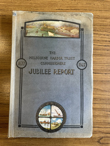
Book, Benjamin Hoare, "The Melbourne Harbor Trust Commissioners Jubilee report 1877-1927", 1927
The "Jubilee History of the Melbourne Harbor Trust" was compiled from the original records of the Trust and from the Victorian "Hansard". Incudes 485 pages of text, images and maps.melbourne harbor trust - port of melbourne authority, piers and wharves, transport - shipping, benjamin hoare -
Port Melbourne Historical & Preservation Society
Map - Chart, Port of Melbourne Authority, Port of Melbourne, 1994
Used in the library of The Polly Woodside Museum before closure1994 Chart of Port of Melbourne with updated annotations by Glen Stuart between 1994 and 2005port of melbourne authority, piers and wharves, melbourne harbor trust - port of melbourne authority, glen stuart -
Port Melbourne Historical & Preservation Society
Pamphlet - Promotional bike map of South Melbourne, Port Melbourne and St Kilda, "Explore by Bike", 1990s
Promotional bike map for the cities of South Melbourne, Port Melbourne and St Kildalocal government - city of port melbourne, local government, city of st kilda, city of south melbourne -
Port Melbourne Historical & Preservation Society
Book, Universal Business Directories (Aust) Pty Ltd, Universal DeLuxe Streets Directory, 1959
1959 Streets Directory for Melbourne City and Suburbs including large scale maps, hospitals, schools, police stations, town halls, telephone booths, tram stops, railways. Fifth edition. Red and Buff cardboard cover, red binding.transport - roads, street directory -
Port Melbourne Historical & Preservation Society
Map - MHT General Plan showing Harbour improvements recommended Sir John Coode, Thomas Kell Lith, 1800s
Black and white map "Melbourne Harbour Trust, General Plan showing Harbour improvements, as recommended by Sir John Coode in his report of 17th February 1879" Showing proposed Coode canal and Sandridge, Hobson's Bay, North Williamstown, Footscray, the City, Emerald Hill and also the buildings of "Kitchen and Son" . (copy of original)industry, manufacturing, engineering department, borough of sandridge, engineering - canals and drainage, melbourne harbor trust - port of melbourne authority, j kitchen & sons pty ltd, sir john coode -
Port Melbourne Historical & Preservation Society
Photograph - Aerial view of Port Melbourne, overlaid, Charter Keck, Cramer, Nov 2006
Black and White aerial photo with red map overlay, labelled "Port Melbourne 1946 overlaid" in gold/brown metal frame . Shows Yarra River, Coode Canal and Hobson's Bay.built environment - industrial, engineering - canals and drainage, coode island, yarra river, melbourne harbor trust - port of melbourne authority -
Port Melbourne Historical & Preservation Society
Map - Lagoon between Ingles and Spring Streets, Sandridge, 26 Mar 1872
Prepared by Mr ORME for the Lagoon Committee and presented with a report on 26.3.1872.Map of Lagoon between Ingles Street and Spring Street. 26 March 1872. In brown wooden frameBorough Surveyor's Stamp in bottom right hand corner.sandridge lagoon, mr orme -
Port Melbourne Historical & Preservation Society
Map - Lagoon and beach, Sandridge, Borough of Sandridge, 1870
Map of Lagoon and beach with soundings, 1870.Signed by Chas. Clay, Borough Surveyor, Sandridge.charles clay, sandridge lagoon -
Port Melbourne Historical & Preservation Society
Map, G S Williams, City Engineer, City of Port Melbourne, Dec 1963
Map of City of Port Melbourne (brick areas marked in colour), 1963.G. S. Williams (City Engineer)town planning, g s williams, troedel and cooper -
Port Melbourne Historical & Preservation Society
Map - Road plans for Fishermens Bend, R S Atkinson, 30 Apr 1946
CRB Map outlining road plans for Fishermens Bend and including the site of the Commonwealth Aircraft Corporation, Aerodrome, General Holdens and C.S.R.I., 1946transport - aviation and aerodrome, industry - manufacturing, fishermans bend -
Port Melbourne Historical & Preservation Society
Map - Williamstown, MMBW, 17 Jul 1894
Melbourne and Metropolitan Board of Works Plan for Williamstown, 1894.Signed W. Thwaites.melbourne and metropolitan board of works, mmbw, williamstown, william thwaites