Showing 2112 items
matching sandhurst.
-
 Bendigo Historical Society Inc.
Document - CROWN LAND TRACINGS, BENDIGO, 1890 - 1910
Document: Crown land tracings, dark buff coloured foolscap paper tied with white tape. On front ' Crown Lands tracings 1890 - 1910'. Contains applications for crown lands, City of Bendigo, 1890 - 1910 including list of allotments, names of persons, locality and tracings of land referred to.place, bendigo, crown land tracings, bendigo, sandhurst, land sales, crown land, crown lands tracings -
Bendigo Historical Society Inc.
Document - RESIDENCE AREAS REGISTER - VOLUME 23 - CORRESPONDENCE, 1935 - 36
Document: correspondence and plans relating to Volume 23 residence areas register. Enclosed inside front cover in plastic pocket.place, bendigo, residence areas, bendigo, sandhurst, land sales, residence areas -
Bendigo Historical Society Inc.
Document - RESIDENCE AREAS REGISTER - INDEX TO VOLUME 23, 1935 - 1936
Document: red and grey book, indexed to Volume 23. Dates 1935 - 1936.place, bendigo, residence areas, bendigo, sandhurst, land sales, residence areas, index -
Bendigo Historical Society Inc.
Document - RESIDENCE AREAS REGISTER: CORRESPONDENCE, 1932 - 1935
Document: correspondence and plans relating to Volume 22 residence areas register.place, bendigo, residence areas, bendigo, sandhurst, land sales, plans, residence areas -
Bendigo Historical Society Inc.
Document - RESIDENCE AREAS REGISTER: INDEX TO VOLUME 22, 1932 - 1935
Document: Index book, blue and buff soft cover. Index to Residence areas register 22.place, bendigo, residence areas, bendigo, sandhurst, land sales, residence areas, index -
Bendigo Historical Society Inc.
Document - RESIDENCE AREAS REGISTER: CORRESPONDENCE VOLUME 21, 1928 - 1932
Document: RESIDENCE AREAS REGISTER - correspondence relating to Volume 21, contained in plastic pocket inside front cover of Volume 21.place, bendigo, residence areas, sandhurst, bendigo, land sales, residence areas register, correspondence -
Bendigo Historical Society Inc.
Document - RESIDENCE AREAS REGISTER: VOLUME 21, 1928 - 1952
Document: RESIDENCE AREAS REGISTER Volume 21. Green covered book, with buff spine and corners. On spine' Registration of residence areas ' and '21'. 202 pages listing residence licenses for Bendigo 21 July 1928 to 3 May 1932. Not indexed,place, bendigo, residence areas, bendigo, sandhurst, land sales, residence areas -
Bendigo Historical Society Inc.
Document - RESIDENCE AREAS REGISTER - CORRESPONDENCE VOLUME 20, 1925 - 1928
Documents; letters and plans that relate to Volume 20 Residence Areas Register. Contained in plastic pocket.place, bendigo, residence areas, bendigo, sandhurst, residence areas register, correspondence -
Bendigo Historical Society Inc.
Document - RESIDENCE AREAS REGISTER: VOLUME 19 INDEX ( 1 OF 2 )
Register: Index of residence areas for register 19. (Two indexes for register 19. - other in Box 56) Dark Maroon cover with lighter material on spine and corners, hard cover containing alphabetical index. Holders of residence area licenses, names and addresses and page number, no book number. On spine ' Index Residence Areas: Written in front in black ink ' Index Book 19'place, bendigo, residence areas, bendigo, sandhurst, land sales, residence areas, register -
Bendigo Historical Society Inc.
Document - RESIDENCE AREAS REGISTER: CORRESPONDENCE FROM VOLUME 19, 1920-1940
Documents: collection of correspondence and plans that relate to Residence Areas Register Volume 19. Covers 1920s to 1930s.place, bendigo, residence areas, land sales, residence areas, plans, sandhurst, bendigo -
Bendigo Historical Society Inc.
Document - RESIDENCE AREAS REGISTER SANDHURST : : VOLUME 19 INDEX, not given
Index book: hard cover book with black cover, spine bound in red. Index to Register 19. 38 x 25 x 2.6 Inside front cover is plastic pocket containing correspondence re widening of Northern Highway, Huntly effecting Mrs. Mary Jane Muston.place, bendigo, residence areas, bendigo, sandhurst, land registers, land sales, residence areas -
Bendigo Historical Society Inc.
Document - RESIDENCE AREAS REGISTER SANDHURST: VOLUME 17, 1899 - 1905
Register: Residence Areas Register: Volume 17. Green covered book, bound in off white paper on spine. January 5 1899 to August 24 1905. 9433 to 13296. Index to above period. Front cover is disconnected from body of book.place, bendigo, residence areas register, bendigo, sandhurst, land register, residence areas, land sales -
Bendigo Historical Society Inc.
Document - RESIDENCE AREAS REGISTER SANDHURST: VOLUME 16, 1894 - 1899
Book: Residence Areas Register: Volume 16. Volume has no cover, spine is in poor condition, bound by white tape to contain pages. Blue lined pages, appears to be complete. October 5, 1894 to January 4,1899. 804 pagesplace, sandhurst, residence areas register, land sales, residents -
Bendigo Historical Society Inc.
Document - RESIDENCE AREAS REGISTER: SANDHURST VOLUME 14, 1892 - 1893
Register: hard covered register, maroon material with dark buff and red spine and corners. No index in front of book. Written on front cover in gold ' Residence Areas Register' On spine '14' Dated 1 February 1892 to 26 June 1893.place, bendigo, residence areas, bendigo, sandhurst, land sales, residence areas -
Bendigo Historical Society Inc.
Document - VICTORIA HILL - THE BENDIGO DIGGINGS, PRELIMINARY DRAFT FOR BROCHURE
Nine typed pages of notes on a preliminary draft for a brochure on the Bendigo Diggings. First part is the objective which is to preserve the mining history and to have exhibits in the places they were used, e.g. quartz mining machinery exhibited in a quartz mining area, not on an alluvial field. Part B is historical notes on the area. Part C is the Site - Victoria Hill area. Part D is Stage One which consists of carpark area, technological museum, restaurant, mineral haulage line, picnic ground, earthworks and planting over the area. Part E is Stage Two which will consist of the open-air exhibits, in the area surrounded by the mineral haulage line, and the Central Nell Gwynne mine on the west side of the site. Part F is Stage Three which will consist of the winery, the steam tram track, the lake, the wildlife sanctuary and various buildings associated with gold mining. Part G is Costing with the prices to be filled in. Parts H and I are the Appeal and the Committee. Details to be filled in.mining, marketing, victoria hill, victoria hill, the bendigo diggings - preliminary draft for brochure, aust national travel association, tullamarine jetport, emu bottom homestead, kyneton historical museum, chinese joss house, eaglehawk museum, whipstick scrub, cairn curran reservoir, castelmaine historical museum and market hall, national trust, ballarat hiatorical park, echuca's hopwood gardens, swan hill folk museum, gibson's mount alexander no 2 squatting run, captain brown, chief commissioner wright, hustler's reef, thomas hustler, mining board, drainage of reefs act 1862, first world war, bendigo amalgamated goldfields, second world war, sandhurst, w c vahland, battery trams, horse trams, steam trams, electric trams, central nell gwynne mine, theodore ballerstadt, george lansell, new chum hill, ballerstadt's open cut, 180 mine, new chum syncline battery, william rae, victoria quartz, wittscheibe's 'jeweller's shop', luffsman and sterry, gold mines hotel, adventure, bendigo and district tourist association, bendigo city council, bendigo branch of the royal historical society of victoria, professor brian lewis, school of architecture and building at the university of melbourne, taylor horsfield, lord robert cecil, south australian gold commissioner -
Bendigo Historical Society Inc.
Document - VICTORIA HILL - CONDENSED HISTORY OF VICTORIA HILL
Handwritten carbon copy of a short history of Victoria Hill. Date on top of page is 13/10/69. Notes mention claims and who bought them and the value of the gold.mine, gold, victoria hill, victoria hill, condensed history of victoria hill, theodore ballerstedt, george lansell, touzeau and co., wm rae, bon accord, victoria quartz, wittscheibe's jeweller's shop, luffsman and sterry, adventure, advance, cinderella, j n macartney, bendigo goldfield registry, the backbone of sandhurst -
 Bendigo Historical Society Inc.
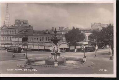
Photograph - VIEW POINT, BENDIGO
black and white photograph: View Point, Bendigo. Alexandra Fountain in middle of photo, tram in Pall Mall on LH side, tram in Mitchell Street facing fountain. Cyclists and pedestrians visible, no motor vehicles.place, bendigo, view point, sandhurst -
Bendigo Historical Society Inc.
Map - PART PARISHES OF MANDURANG AND SANDHURST, No date visible
Map: Section of Parish plan of Bendigo covering Mandurang, Diamond Hill, and Quarry Hill, ( number 147 in Map Cupboard 1).Map 11map, bendigo, city streets, parish of mandurang, parish of sandhurst, diamond hill , quarry hill -
Bendigo Historical Society Inc.
Map - PART PARISHES OF SANDHURST MARONG AND NERRING, No date visible
Map: Section of a Parish plan of Bendigo, covering Ironbark, Eaglehawk and Myers Flat ( number 145 in Map Cupboard 1)map, bendigo, city streets, parish of sandhurst, parish of marong, parish of nerring, ironbark, eaglehawk, myers flat -
Bendigo Historical Society Inc.
Map - PARISH OF HUNTLY(PART) AND SANDHURST(PART), No date visible
Map: Part of parish plan of Bendigo, covering Strathdale, White Hills, Huntly and North Bendigo ( number 144 in Map Cupboard 1)map, bendigo, city streets, parish of hunlty, parish of sandhurst, strathdale, white hills, huntly, north bendigo -
Bendigo Historical Society Inc.
Map - SANDHURST, No date Visible
Map: Parish plan showing the Northern section of the Municipalitymap, bendigo, parish plan, sandhurst -
Bendigo Historical Society Inc.
Map - SANDHURST (PART), Circa 1880's
Map: Parish plan showing an area from McKenzie/View streets to Long Gully ( number 232 in Map Cupboard 1)map, bendigo, parish plan, sandhusrt, mckenzie street , view street, long gully -
Bendigo Historical Society Inc.
Map - SANDHURST (PART), Circa 1880's
Map: Parish plan covering the area from Belle Vue Rd. to Barnard St. and Maple St to Short St. ( number 230 in Map Cupboard 1)map, bendigo, parish plan, sandhurst, belle vue road, barnard street, maple street , short street -
Bendigo Historical Society Inc.
Map - SANDHURST (PART), Circa 1880's
Map: Parish plan showing Charleston Rd. Lloyd St. areamap, bendigo, parish plan, sandhurst, charleston road, lloyd street -
Bendigo Historical Society Inc.
Map - SANDHURST (PART), Circa 1880's
Map: Parish plan showing the area Specimen Hill Road and Inglewood St. ( number 222 in Map Cupboard 1)map, bendigo, parish plan, specimen hill rd. inglewood st. -
 Bendigo Historical Society Inc.
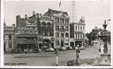
Photograph - VIEW POINT BENDIGO
Photograph - black and white. Photo of View Point Bendigo. Fountain right hand side of photo. A large clock on top of Armstrong Tyre Service. Also Australian Mutual Provident Society, Colonial Mutual Life Building and other buildings. No.14 on right hand bottom of photo. Newsagent advertising The Herald, Age, The Sun, Argus.place, bendigo, view point, sandhurst, view point bendigo. -
 Bendigo Historical Society Inc.
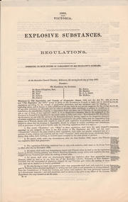
Document - EXPLOSIVE SUBSTANCES REGULATION 1882, 1882
5 copies of paper. Explosive substances, regulation.Rob Wadsworth, clerk to the executive councilgovernment, state, mines act, bendigo, sandhurst, explosives, regulations, mining -
Bendigo Historical Society Inc.
Map - BENDIGO (SANDHURST) PART, No date visible
Map: Parish plan showing an area North West from the McKenzie St. View St. corner to Long Gully ( number 220 in Map Cupboard 1)map, bendigo, parish plan, bendigo, long gully -
Bendigo Historical Society Inc.
Map - SANDHURST (PART), Circa 1880's
Map: Parish plan sowing an area along Specimen Hill Rd. ( number 211 in Map Cupboard 1)map, bendigo, parish plan, specimen hill rd. sandhurst , bendigo -
Bendigo Historical Society Inc.
Map - SANDHURST (PART), No date Visible
Map: Hand Draughted parish plan showing the area North and East of Spring Gully Reservoir ( number 206 in Map Cupboard 1)map, bendigo, parish plan, parish of sandhurst, spring gully