Showing 10721 items
matching sites
-
 Ringwood and District Historical Society
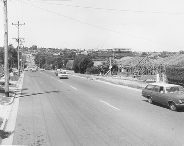
Photograph, Warrandyte Rd. looking south towards Maroondah Hwy. Eastland second storey being built - c.1974
Typed below photograph, "Warrandyte Rd. looking south towards Maroondah Hwy. Eastland second storey being built - 1974?" Catalogue card states, "Frames to right are on site of 'Woodside' - Miss Huttons house". -
 Marysville & District Historical Society
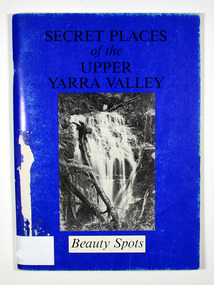
Book, Secret Places of the Upper Yarra Valley-Beauty Spots, 1994
A book describing beauty spots and waterfalls in the Upper Yarra ValleyPaperback. Front cover has a black and white photograph of Mathinna Falls.A selection of beauty spots within the Upper/ Yarra Region, which once made the valley/ Victoria's foremost tourist destination./ Many of the sites have since been neglected or/ closed to public access, leaving tourists to pass by,/ and travel on to distant places./ By associating episodes of our fascinating past/ with these sites, we learn that there is more than/ just natural beauty to be re-discovered. Stamp of Marysville & District / Historical Society Inc / P.O. Box 22 / Marysville 3779upper yarra valley, beauty spot, waterfalls -
 Federation University Historical Collection
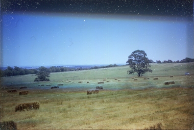
Slide, Site of the Mount Helen Campus, 1967, 1967
The site of the Mount Helen Campus was purchased in 1967, with students on site from 1970. It had originally been the Latta/Downing farm. Two images of a farm at Mount Helen that was purchased for use as the Mount Helen Campus of the Ballarat School of Mines, later Ballarat Institute of Advanced Education. ballarat school of mines tertiary division, mount helen campus, ballarat institute of advanced education, farm, hay bales, agriculture -
 City of Ballarat Libraries
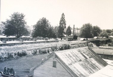
Photograph - Card Box Photographs, Former Saleyards on Doveton Street North, Ballarat 1959
View looking north west over the former saleyards on Doveton Street North. The site would be used as the site for the Civic Hall.saleyards, doveton street north, civic hall, building, streetscape -
 Greensborough Historical Society
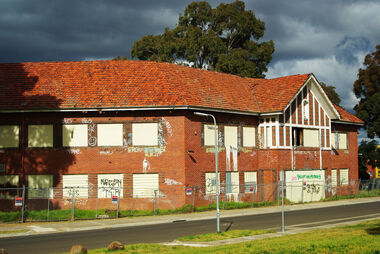
Photograph - Digital Image, Marilyn Smith, Larundel. Blocks A and B, front, 05/09/2017
This photograph shows the front of Blocks A and B at the old Larundel Hospital site. Some buildings on this site are heritage listed on the Victorian Heritage Database.Digital copy of colour photographlarundel hospital -
 Greensborough Historical Society
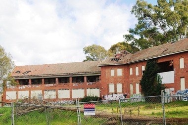
Photograph - Digital Image, Marilyn Smith, Larundel. Block B, rear, 05/09/2017
This photograph shows the rear of Block B at the old Larundel Hospital site. Some buildings on this site are heritage listed on the Victorian Heritage Database.Digital copy of colour photographlarundel hospital -
 Greensborough Historical Society
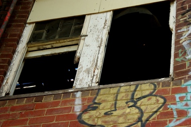
Photograph - Digital Image, Marilyn Smith, Architectural detail at Larundel, 05/09/2017
This photograph shows architectural detail on buildings at the old Larundel Hospital site. Some buildings on this site are heritage listed on the Victorian Heritage Database. Digital copy of colour photographlarundel hospital -
 Federation University Historical Collection
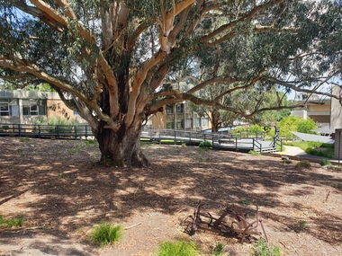
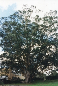
Photograph - Photograph - Colour, The Tree of Knowledge, 2020, 26/02/2020
The 'Tree of Knowledge' was planted on Arbor Day 1896 by Mrs Elizabeth Downing who lived on the farm that was originally the Mount Helen Site. When the site was purchased in 1966 the architects and planners inspected the site and decided 'The Big Tree' must remain as a central landmark in preparing the layout of the campus.Photograph of the 'Tree of Knowledge', a Tasmanian Blue Gum (Eucalyptus glubulus labillo), located at the Mount Helen Campus of Federation University. The tree is registered by the National Trust,federation university, federation university australia, feduni, university of ballarat, mount helen, tree of knowledge, big tree, blue gum, mount helen campus -
 Federation University Historical Collection
Photograph - Newsprint, The Tree of Knowledge, c2000, c2000
The 'Tree of Knowledge' was planted on Arbor Day 1896 by Mrs Elizabeth Downing who lived on the farm that was originally the Mount Helen Site. When the site was purchased in 1966 the architects and planners inspected the site and decided 'The Big Tree' must remain as a central landmark in preparing the layout of the campus.Photograph of the 'Tree of Knowledge', a Tasmanian Blue Gum (Eucalyptus glubulus labillo), located at the Mount Helen Campus of Federation University. The tree is registered by the National Trust,federation university, feduni, university of ballarat, mount helen, tree of knowledge, big tree, blue gum -
 Federation University Historical Collection
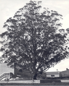
Photograph - Photograph - Black and White, The Tree of Knowledge, c1979, c1979
The 'Tree of Knowledge' was planted on Arbor Day 1896 by Mrs Elizabeth Downing who lived on the farm that was originally the Mount Helen Site. When the site was purchased in 1966 the architects and planners inspected the site and decided 'The Big Tree' must remain as a central landmark in preparing the layout of the campus.Photograph of the 'Tree of Knowledge', a Tasmanian Blue Gum (Eucalyptus glubulus labillo), located at the Mount Helen Campus of Federation University. The tree is registered by the National Trust,federation university, federation university australia, feduni, university of ballarat, mount helen, tree of knowledge, big tree, blue gum, mount helen campus -
 Federation University Historical Collection
Photograph, Site of Sovereign Hill and Ballarat Lodge
The Old Ballarat Travel Inn was located at 613 Main Road. It later Became Ballarat Lodge and Mecure Ballarat.Photograph showing the site of Sovereign Hill in fron to the pine trees, and Elsmore street running along the right. Ballarat Lodge, the brainchild of John Gilbert, can be seen in front of the dam in the centre. The start of Magpie Street can be seen on the left hand side of the photograph.ballarat lodge, john gilbert, sovereign hill, elsmore street, main road, ballarat east, old ballarat travel inn -
 Glenelg Shire Council Cultural Collection
Photograph - Photograph - Portland Harbour, n.d
Port of Porltand Authority Archivesport of portland archives, portland harbour -
 Bendigo Historical Society Inc.
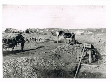
Photograph - WES HARRY COLLECTION: LANDSCAPE VIEW OF EARLY BENDIGO GOLD MINES
Black and white photo copy: Image shows mine site, horse harnessed to puddling machine, shaft in immediate foreground, with pipe extending into top of shaft. Horse harnessed to cart on LH side. Very early image of mining in Bendigo, no poppet heads visible.Batchelderplace, bendigo, mining, bendigo, mining, gold, puddling -
 Bendigo Historical Society Inc.
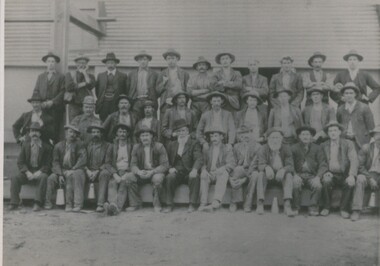
Photograph - SOUTH NEW MOON MINE - WORKERS, 1906 ?
black and white photo : mine site with workers. South New Moon Mine - Sam Bartlett centre front, mine manager ( James Lerk, 26th. Nov. 1999 ) 3 rows of males, dressed in jackets, hats. Standing in front of corrugated iron buildingperson, group, south new moon mine -
 Bendigo Historical Society Inc.
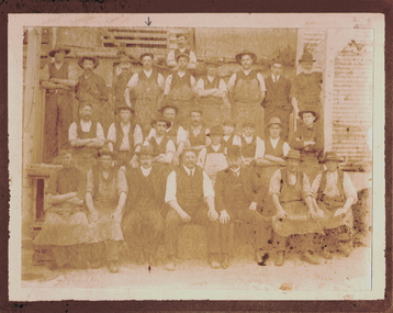
Photograph - COHN BROS EMPLOYEES, c.1906
Sepia photograph of employees at Cohn Bros. at factory site. Mounted on grey board. Inscriptions: on back - hand written 'Cohn's Brewery 1906, Employees' in ink. 'About 1906' (black lead pencil), 'Royal Historical Society Victoria, Bendigo Branch', circular stamp.person, group, employees, see also 2001.219.01. prev. acc no. gp56 -
 Bendigo Historical Society Inc.
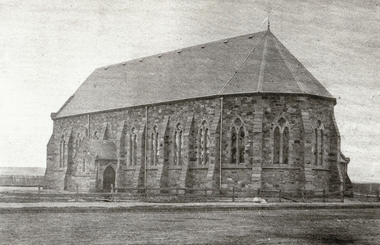
Photograph - ST. KILLIAN'S CHURCH, 1861
black and white photo : ( copy ) stone church building, with buttresses, and portico on side. Slate ( ? ) roof. Post and rail fence across front of church, paling fence visible at side and rear. Original St. Killian's church, on site corner McRae and Chapel Street.Batchelderorganization, church, st. killian's -
 Bendigo Historical Society Inc.
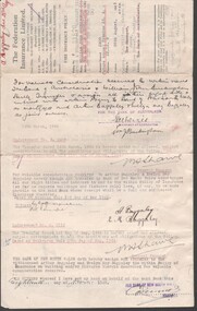
Document - BAGGALEY COLLECTION: FEDERATION INSURANCE POLICY FOR 518 HARGREAVES STREET, BENDIGO
Fire insurance Policy, through The Federation Insurance Limited, for property including three buildings on the site of 518 Hargreaves Street, Bendigo. Policy transfer from arthur & E.M. Baggaley to William John Buckingham Variously dated 1943 to 1955 More research required -
 Bendigo Historical Society Inc.
Document - MCCOLL, RANKIN AND STANISTREET COLLECTION: INDENTURE NO. 11299 BENDIGO, 1952
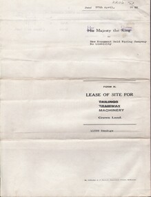
Document: Mew Monument Gold Mining Co N/L. 11299 lease for site of machinery 27/4/1952. Signature Asst. Registrar of Titles His majesty King George VI cancelled & replaced by stamp Her majesty Queen Elizabeth II.MCCOLL RANKIN & STANISTREETorganization, business, gold mining lease, mccoll ranking & stanistreet -
 Bendigo Historical Society Inc.
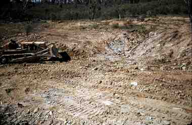
Slide - RALPH BIRRELL COLLECTION: EIG SCHOOL, 1966
EIG School - Ralph Birrell Collection. - Construction of Latrobe Uni. C1969. Bendigo Institute of Technology, Engineering School, Applied Science. Workman with grader, he has been grading the site ready for paths, gardens etc. Markings Made in Australia, MAY 69MKodakeducation, tertiary, latrobe university bendigo, eig school - ralph birrell collection. - construction of latrobe uni. c1967. bendigo institute of technology, engineering school, applied science. workman grader, grading site paths, gardens etc. -
 Bendigo Historical Society Inc.
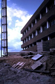
Slide - RALPH BIRRELL COLLECTION: EIG SCHOOL, C1966
EIG School - Ralph Birrell Collection. - Construction of Latrobe Uni. C1966, 1972. Bendigo Institute of Technology, Engineering School, Applied Science. Building appears complete, tower has been erected, site needs to be cleaned up of building supplies. Markings: OCT72M2Kodakeducation, tertiary, latrobe university bendigo, eig school - ralph birrell collection. - construction of latrobe uni. c1966, 1972. bendigo institute of technology, engineering school, applied science. building complete, tower erected, site needs cleaned up -
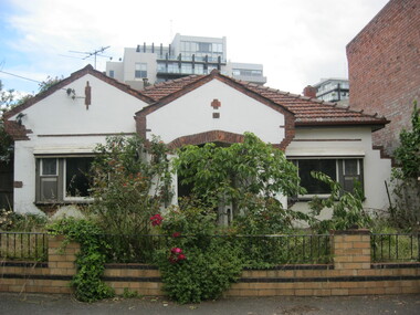 Port Melbourne Historical & Preservation Society
Photograph - 51 Esplanade West, Port Melbourne, c. 2010
Photograph of house formerly at 51 Esplanade west, corner of Rouse Street. House built in the inter-war period. Council approved a four 3 storey development with 8 on-site car parks in 2008. It was appealed to VCAT but unsuccessfully and the house was demolished in December 2010built environment - domestic, esplanade west -
 Bendigo Historical Society Inc.
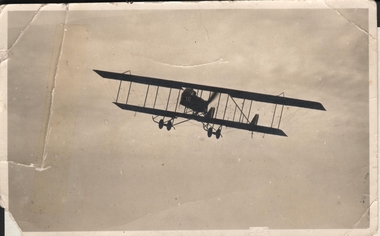
Postcard - BIPLANE FLOWN BY CURNOW BROTHERS
Black and white photo. Image shows biplane in air. Donor information: 'plane flown by two Curnow brothers, joyflight in 1920. Flown from site 'opposite to Bendigo Golf Club' This was the first flight by the father, James Lesley Ennis, of the donor, Hugh Ennis.`aviation, civilian, hugh ennis -
 Bendigo Historical Society Inc.
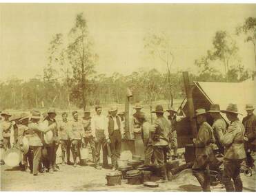
Photograph - CASLEY COLLECTION: GROUP OF MEN IN ARMY UNIFORM
Black and white photograph . Group of men, some in normal clothes and in army uniform, some men are carrying buckets and pans. To the right a tent and 2 stoves and lots of buckets and pans. On back of photo: 21st October, 1912. World War 1 camp site.W.H. Robinsonorganization, military, casley collection. army personnel. -
 Bendigo Historical Society Inc.
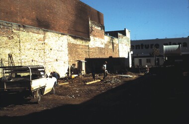
Slide - ALLAN BUDGE COLLECTION: SLIDE FORMER MCCALMAN'S STORE, 1988
Slide, ALLAN BUDGE COLLECTION. Standing on the site of the former McCalman's store after it was burnt out, looking across Hargreaves Mall at Venture Plaza (now the Hargreaves Mall entrance to Myer). Scene after clearance of fire wreckage. Photo taken in April 1988.house, public, allan budge collection, allan budge collection -
 Hume City Civic Collection
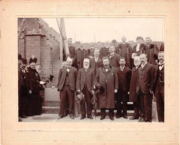
Photograph
The photo was taken to record the laying of the foundation stone of St. Andrew's Presbyterian Church (now St. Andrew's Uniting Church) Sunbury 1904.A mounted sepia photograph of a group of men and one woman standing on a construction site and in front of a foundation stone. There are 22 men in the photograph with 7 of them dressed in clerical attire. The other men are wearing dark suits. Cream mounting 1.5cm x 2.5 cm.CHR. CHRISTIANSENclergymen, st. andrew's uniting church, churches, foundation stones, christiansen, chris, photographers, sunbury, clothing and dress, men, st. andrew's presbyterian church, george evans collection -
Whitehorse Historical Society Inc.
Map, Township of Norwich, ca 1850
Plan of the Township of Norwich being subdivision of Section III, Parish of Nunawading, County of Bourke, consisting of suburban farms, vineyard sites and town lots, for sale by auction by W. Casey & Co. [c. 1850]. Original in Vale Maps Collection, La Trobe Library.norwich village, vermont, parish of nunawading, vermont south, maps -
 Lakes Entrance Historical Society
Photograph, 2008
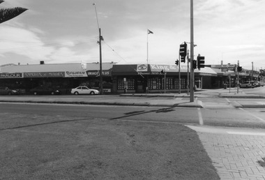
Date made August 2008Colour photograph of the retail stores - Icecream Parlour, Stitches and Things, Lakes Photographics and King and Heath Real Estate - on the corner of Myer Street and Esplanade, the only traffic lights in the town also shown. The original site of St Rosieres Guesthouse. Lakes Entrance Victoriaguesthouses, retail trade, room display -
 Southern Sherbrooke Historical Society Inc.
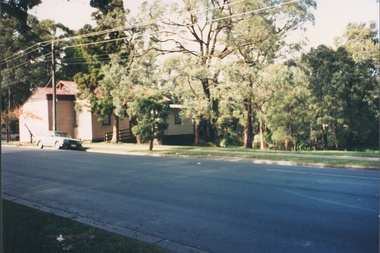
Photograph - The site at 127 Colby Drive, Belgrave Heights, before relocation of the former St Martins Anglican Church and Hall
Two colour photos show the site at Belgrave Heights just before the relocation of the former St Martins Anglican Church and Hall. Both photos show the Progress Hall beside an area of grass where the buildings were positioned on Sunday 2nd July 1995. -
 Ballarat Tramway Museum
Photograph - Digital image Set of 4, Warren Doubleday, 5/01/1974 12:00:00 AM
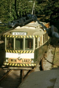
Set of 4 digital images of: .1 - No. 27 on the BTPS Depot fan during overhead work from another tram - 5-3-1974 .2 - No. 27 on the access track - power was not on. .3 - ditto from Wendouree Parade .4 - the site for a junction to the depot.trams, tramways, btps, depot, overhead, wendouree parade, tram 27 -
 Bendigo Historical Society Inc.
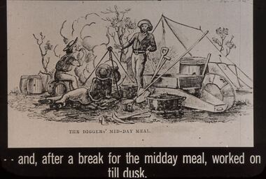
Slide - DIGGERS & MINING: THE DIGGINGS - THE DIGGERS
Diggers & Mining: The Digging - The Diggers. Slide depicts miners relaxing back at the camp site. Puddling machine, gold pan, shovel and other items needed by miners, there is also a tent. Not many trees. Markings: 31 994.LIF:6. Used as a teaching aid.Hanimounteducation, tertiary, goldfields