Showing 1398 items
matching 'maroondah'
-
 Ringwood and District Historical Society
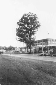
Photograph, Maroondah Highway West, Ringwood- The last remaining naturally grown gum tree on the Maroondah Highway between Ringwood and the city, cut down 1959. before it was cut down from out the front of Bill Patterson Motors in 1959 - a yellow box tree 60 feet high and 75 years old
Black and white photograph (2 copies)Typed below one photograph: "The last remaining naturally grown gum tree on the Maroondah Highway between Ringwood and the city before it was cut down from out the front of Bill Patterson Motors in 1959. Was a yellow box tree 60 feet high and 75 years old." -
 Ringwood and District Historical Society
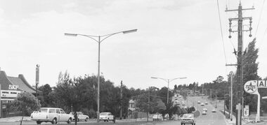
Photograph, Maroondah Highway East, Ringwood- 1971. Looking east towards Mt Dandenong Road
Black and white photographWritten on back of photograph: "Maroondah Highway, looking east towards Mt Dandenong Road turnoff past lake. 1971." -
 Ringwood and District Historical Society
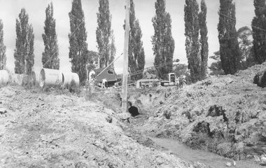
Photograph, Maroondah Highway East, Ringwood- 1963. Excavations for Ringwood Lake overflow
Black and white photograph (2 copies- 1 large, 1 smaller)Typed on rear of backing sheet of large photograph: "Ringwood lake overflow pipe. (Passing under Maroondah Highway). 1963. -
 Ringwood and District Historical Society
Photograph, Maroondah Highway West, Ringwood- 1939. Looking east from Heatherdale Rd
Black and white photograph (2 copies)Typed below one photograph: "Maroondah Highway looking East from SEC pylon at substation in Heatherdale Road, 1939. -
 Ringwood and District Historical Society
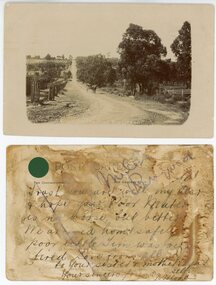
Photograph, Maroondah Highway Central, Ringwood. Warrandyte Rd looking North from Main Street, Ringwood. 1908
Black and white photograph reproduced from post card. Scene of road looking towards Loughnan Hill, Andrew Kennedy's orchard. Horse and cart in centre of photo, orchard to left of picture. (3 enlarged copies, 2 postcards, a clipping and 1 9x18.5 reproduction) Postcards with correspondence from N Blood, 2 original of the postcards with messages. First reads: "Trust you are well my dear and hope your poor Mater is no worse but better. We arrived home safely..poor little Tim was very tired. Love from all to your sister and mother..self. Your sincere friend, N. Blood" Second Reads: "Miss Hill. Cowes P.O.. 4/3/09 Dear Olive, come at once; I am on my last legs! Very pleased to hear that you have been enjoying yourself as well. Your mother had been very ill and Elvie has lost a stone weight; and ??? looks down in the dumps. Topsy killed canary this morning so I took Topsy for a walk! Had a bush fire up at home on 22 and 23rd Feb. No time to scribble more. Yours to a cinder. Bert." This postcard writing is overstamped J.B.McAlpin, Estate and Financial Agent. District Government Valuer Ringwood. It has a 1d Victorian Stamp affixed. Typed below photograph, "Warrandyte Rd. from Maroondah Hwy. looking north. Mullum Creek bridge in dip - 1908". -
 Ringwood and District Historical Society
Photograph, Maroondah Highway Central, Ringwood. Looking west from Warrandyte Road, 1960. Taken from clock tower
Black and white photograph (2 copies)Written on back of one copy: "Maroondah Highway looking west from clock tower, 1960. Road being reconstructed." -
 Ringwood and District Historical Society
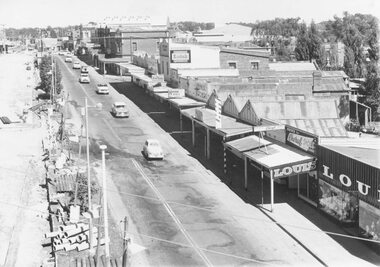
Photograph, Maroondah Highway Central, Ringwood. Shopping strip on the south side opposite Town Hall and Midway Arcade- 1974
Black and white photograph (2 copies)Backing sheet reads, "Shops opposite Town Hall and Midway Arcade 1974". ANZ Bank at 116 Maroondah Highway. -
 Ringwood and District Historical Society
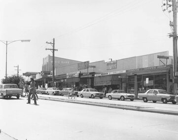
Photograph, Railway Station precinct shops, south side of Maroondah Highway, Ringwood - 1969
Black and white photograph Image shows shops on south side of Maroondah Highway between railway station entrance and clocktower site at Wantirna Road. -
 Greensborough Historical Society
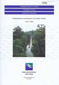
Pamphlet, Lower Plenty River concept plan, summary report: Maroondah Pipetrack to Yarra River, 1992_07
This draft concept plan covers the lower Plenty River from the Maroondah Pipe track in Greensborough to where the Plenty meets the Yarra. Melbourne Water was the lead agency, assisted by the Shires of Eltham and Diamond Valley, City of Heidelberg, the EPA and Department of Planning and Housing.Coloured pamphlet, photograph and plans 12 pages. 2 copies.plenty river, maroondah aqueduct, melbourne water -
 Ringwood and District Historical Society
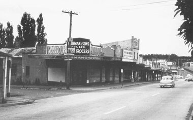
Photograph, Maroondah Highway Central, Ringwood. Corner Main Street & Adelaide St. looking east towards Warrandyte Road- 1966
History of the Norman Cash Grocery Stores. Normans started grocery store in Drummond Street Oakleigh in 1903 and expanded to 13 stores in adjacent suburbs, Ringwood being one of these. Photo is Norman & Sons P/L corner of Maroondah Highway and Adelaide Street.Black and white photograph (2 copies) Typed below one copy: "Corner Main Street & Adelaide St. looking east towards Warrandyte Road - 1966". Image shows Norman & Sons Grocer store on corner of Adelaide Street and Main Street. -
 Eltham District Historical Society Inc
Slide, Maroondah Aqueduct, Research, Victoria, 22 Mar. 1981
An inspection tour of the Maroondah Aqueduct was undertaken by the Shire of Eltham Historical Society on Sunday, March 22nd, 1981, commening where the aqueduct crosses Main Rd., Research, just below Eltham College. The Maroondah Aqueduct was part of Melbourne’s water supply system. It carried water over the 66 km from the Maroondah Reservoir on the Watts River at Healesville to the Preston Reservoir. Of this length, 41 km were open channel, 10 km, tunnel through hills and 15 km in 14 inverted siphons across stream valleys. The route of the aqueduct is north of Tarrawarra and Yarra Glen, along the Yarra escarpment south of Christmas Hills and crossing Watsons Creek into the present Shire of Eltham near Henley Rd. The eastern part of the route lies entirely within the former boundaries of the shire. The aqueduct passes south of Kangaroo Ground to Research and crosses the Diamond Creek by siphon at Allendale Rd., Eltham North. It then extends to Reservoir via St. Helena, Greensborough North and Bundoora. Water first flowed through the aqueduct in February 1891 when it was fed by a diversion weir on the Watts River. Records of the building of the aqueduct indicate that it was a significant construction achievement. The present Maroondah Reservoir was completed in 1927 and the aqueduct was enlarged at that time to take increased flows. About 1971 the section of the aqueduct through and north of Research was replaced by a large pipe and that section of the channel is now unused. The channel has remained largely intact (unlike sections at Greensborough and Bundoora where long lengths of the disused aqueduct have been demolished or filled in). The M.M.B.W. relinquished control of the disused aqueduct reserve which is crown land and the Shire of Eltham took control of this section of the reserve as a linear park. The Maroondah Aqueduct is considered to be an important historic structure, not just to the local area but to the metropolitan area generally. It is considered important to preserve substantially intact long lengths of the disused aqueduct, together with its bridges and other associated structures. 35 mm colour positive transparency (1 of 5) Mount - Agfachrome Agfa CS System black 8 dotsactivities, heritage excursion, maroondah aqueduct, research (vic.), shire of eltham historical society -
 Ringwood and District Historical Society
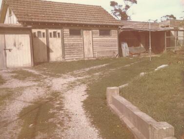
Photograph, Sheds - Wilsmore's property 90 Maroondah Hwy Ringwood. 1967. (4 photos)
Set of 4 photos taken in relation to the Interim Development Order, May 1963 - EastlandWritten on back of photograph, "9 May 1967. 90 Maroondah Highway. Photograph taken at 11 a.m. by M. Kirkwood in the presence of D.G. Potts". Handwritten on envelope: "Sheds-Wilsmore's Property 90 Maroondah Hway", and on label "Area covered by the Interim Development Order, May 1963 - Eastland." -
 Ringwood and District Historical Society
Pamphlets, Council Annual Reports, 1956 to Ringwood Ratepayers and 1976 to Citizens of Ringwood, and Invitation to Maroondah Trade and Industry Development Group Luncheon, 1974, 1. 25-Oct-1974|2. Jan 1956|3. 3-Nov-1976
Three pamphlets relating to Ringwood's Development and notices to ratepayers.1. Invitation. Orange coloured bifold with black printing; 2. Report. White four page foolscap. Black printing. Borough Crest on front page.; 3. Report. Cream bifold with blue printing. Map with 5 photos. +Additional Keywords: Kelly, Alfred (Town Clerk) / Smart G.R.B. (Mayor)1.Trade and Industry development group - Maroondah.; 2. Ringwood Council Annual Report to the ratepayers.; 3. A report to the citizens of Ringwood. -
 Ringwood and District Historical Society
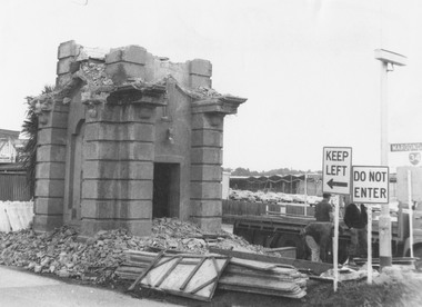
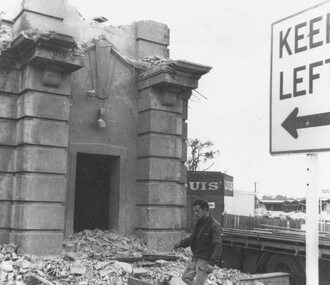
Photograph, Demolition of old Ringwood Clocktower at the corner of Warrandyte Road and Maroondah Highway, Ringwood - 1967, 1967
Black and white photographs of partly demolished clocktower.Typed below photograph, "Demolition of old clocktower on Maroondah Hwy. at corner of Warrandyte Rd. Eastland being constructed in background - 1967". -
 Ringwood and District Historical Society
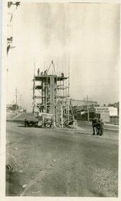
Photograph, Maroondah Highway Central, Ringwood. Building Ringwood Clocktower-1928. (2 images), 1928
Black and white photographs. (2 images- 1 large, 1 small identical, 1 small different image.)Typed on backing sheet of large photograph: "Building Ringwood clocktower on old site on Maroondah Hwy and Warrandyte Rd corner- 1928." -
 Ringwood and District Historical Society
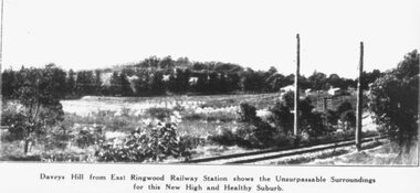
Photograph, Image used for land sale promotion of East Ringwood Railway Estate - 1925. Davey's Hill shown in the photograph later became the site of Maroondah Hospital adjoining Davey Drive, Ringwood East
Catalogue card reads, "Railway Estate 1925. Daveys Hill East Ringwood. Daveys Hill is now Maroondah Hospital ground." -
 Ringwood and District Historical Society
Photograph, Demolition of old Ringwood Clocktower at the corner of Warrandyte Road and Maroondah Highway, Ringwood - 1967, 1967
Black and white photographs of partly demolished clocktower.Typed below photograph, "Demolition of old clocktower on Maroondah Hwy. at corner of Warrandyte Rd. Eastland being constructed in background - 1967". -
 Ringwood and District Historical Society
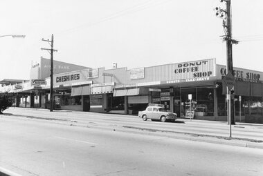
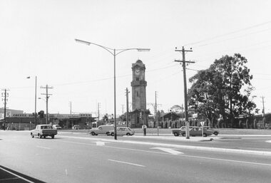
Photograph, Maroondah Highway and Wantirna Road intersection 1969
Black and white photographImage shows clocktower in new location on corner of Maroondah Highway and Wantirna Road, and shops including Antwan's hair fashions and OPSM. -
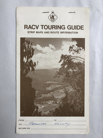 Robin Boyd Foundation
Map, RACV, RACV Touring Guide
Strip maps and route information for via the Maroondah Highway from melbourne to benalla.In blue pan Maroondah Highway.walsh st library -
Ringwood and District Historical Society
Minute Book, Henley Carnival Maroondah Hospital Auxiliary Annual Reports 1966-1977, 1966-1977
Minute book used by the Henley Carnival Maroondah Hospital Auxiliary to record their annual reports 1-11 from 1966-1977.; Orange and red covered project book (Embassy). pp.64 not all used. +Additional Keywords: Wood, Amy (Pres.) / Thomas, D (Hon. Sec) -
Whitehorse Historical Society Inc.
Pamphlet, Maroondah Highway, Nunawading, 1/10/1999 12:00:00 AM
Auction brochure for 360 Maroondah Highway, Nunawading [Whitehorse Road].Auction brochure for 360 Maroondah Highway, Nunawading [Whitehorse Road]. 3 lots for auction, 27 October 1999. Agent; Collier. Site of the former Nunawading Council Chambers. Includes aerial photo of Nunawading including Whitehorse Rd / Springvale Rd corner and Nunawading Railway Station area.Auction brochure for 360 Maroondah Highway, Nunawading [Whitehorse Road]. whitehorse road, nunawading, no 360, city of nunawading. council chambers, municipal chambers, springvale road, nunawading, nunawading railway station -
 Eltham District Historical Society Inc
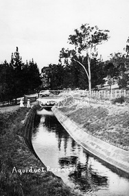
Photograph, Tom Prior, Maroondah Aqueduct, Research, Vic, c.1895
Built for opening in 1891 to take water from Maroondah to Reservoir. Part of a slide show presentation "Bridges & Waterways of the Shire" by Russell Yeoman to the 13 September 1989 Society meeting. The presentation included slides of historic photos from the Shire of Eltham Pioneers collections as well as several recent views.This photo forms part of a collection of photographs gathered by the Shire of Eltham for their centenary project book,"Pioneers and Painters: 100 years of the Shire of Eltham" by Alan Marshall (1971). The collection of over 500 images is held in partnership between Eltham District Historical Society and Yarra Plenty Regional Library (Eltham Library) and is now formally known as the 'The Shire of Eltham Pioneers Photograph Collection.' It is significant in being the first community sourced collection representing the places and people of the Shire's first one hundred years. The Reynolds family were early settlers in Research. The Reynolds/ Prior collection of photographs were taken by Tom Prior, the maternal uncle of Ivy Reynolds, around 1900 and the 60 photos in the album give a fine overview of many of the landmarks of Research and Eltham over 100 years ago. lvy lived in the family home for many years at 106 Thompson Cres Research. Ivy's father, Ernst Richard Reynolds and grandfather, Richard Reynolds, lived at the same address. Ivy's father Richard worked for Mr. Trail on his property in Research. Reynolds Road is named after the family. Mr Tom Prior (wife Eva) worked at the Melbourne zoo. He was very innovative and made his own camera, using the black cloth hood to exclude the light. The photographs are a reminder of the rural nature of Research and Eltham and its rich heritage.Digital image (Neg copy missing)shire of eltham pioneers photograph collection, research (vic.), maroondah aqueduct, aqueduct, reynolds prior collection -
 Ringwood and District Historical Society
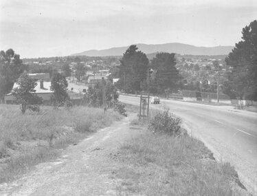
Photograph, Maroondah Highway West, Ringwood- c1948. Looking East from Heatherdale Road
Black and white photograph (2 copies)Typed below photograph: "Maroondah Highway. Taken from near Heatherdale Road - 1948". Written on back of another copy, "Coming into Ringwood". -
 Ringwood and District Historical Society
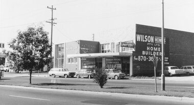
Photograph, Maroondah Highway West, Ringwood- 1969. Near Wantirna Road
Black and white photographWritten on back of photograph: "May 1969" Image shows 'National Bank', and 'Newman & Ritchie Estate Agents' on south side of Maroondah Highway. -
 Eltham District Historical Society Inc
Document - Folder, Maroondah Acqueduct, 2008
Pages copied from the The Heidelberg Historian, newsletter of the Heidelberg Historical Society, February and June 2008 isues relating to guest speaker Lindsay Mann, President of Whittlesea Historical Society and his subject Yan Yean Reservoir: 150 years. - Folder 82 from Harry Gilham Collection. Material merged with folder on Maroondah Reservoir Various pagesyan yean reservoir, lindsay mann, heidelberg historical society, water supply, maroondah reservoir -
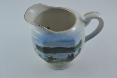 Melbourne Water
Souvenir Porcelain Milk Jug, 1910-1930
The Maroondah System was first and foremost developed as a functional component of Melbourne's Water Supply System. In addition to functionality, the Melbourne and Metropolitan Board of Works (MMBW) envisioned the Maroondah Reserve to be enjoyed aesthetically and recreationally by the public. This souvenir illustrates the realisation of the Maroondah System as a local recreational and tourist attraction in the early 20th century. The Maroondah Reserve gardens were landscaped with English-style ornamental stonework, exotic trees, flower beds and rose gardens. All features of the water supply system became widely celebrated as beauty spots that continue to be very popular to this day with tourists and locals alike. This souvenir is a product of that flourishing tourist trade. These water supply sites continue to enhance Melbourne’s charm and liveability and are now recognised as places of cultural and historic significance.This souvenir milk jug has been curated by Melbourne Water as it represents an important historical aspect of the organisation by demonstrating the popularity of its water asset sites as recreational places and tourist attractions, and although these sites are functional parts of the water supply system, they were also designed to be enjoyed by the public both aesthetically and recreationally. Additionally, this item is aesthetically significant as it represents the style and design of the early 1900s.This souvenir white-glazed porcelain milk jug features gold trim and an illustration of the Maroondah Outlet in the centre, with the transfer “Maroondah Dam, Healesville, Vic”. -
 Ringwood and District Historical Society
Photograph, Invitation from the Ringwood Historical Research Group on 25th October 1974. From the Ellie Pullin MBE and members of the RHRG to Mrs G Horman. To hear Hugh Anderson, author of the "Place of Many Eagles" at the Civic Centre, Maroondah Highway, Ringwood
Invitation from the Ringwood Historical Research Group on 25th October 1974. From the Ellie Pullin MBE and members of the RHRG to Mrs G Horman. To hear Hugh Anderson, author of the "Place of Many Eagles" at the Civic Centre, Maroondah Highway, Ringwood. All material is from Gwen Horman’s three albums that she owned.