Showing 515 items matching " big hill."
-
 Bendigo Historical Society Inc.
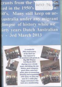
Mixed media - DUTCH AUSTRALIAN FRIENDS INC, 1940-2013
... of the Duch Australian Friends Inc. held the 3rd of March 2013 at Big.... held the 3rd of March 2013 at Big Hill Winery. Mixed media ...Two DVD recording the celebration of the thirty years of the Duch Australian Friends Inc. held the 3rd of March 2013 at Big Hill Winery.dutch australian friends, 2013 -
 Bendigo Historical Society Inc.
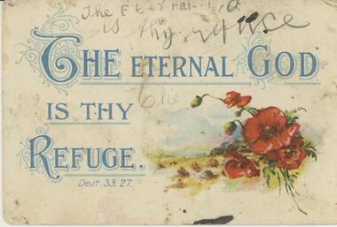
Postcard - Alice McGregor Postcard Collection, 1900 - 1920
... Undated. On the back 'Ruby Grey, Crusoe Road, Big Hill... Undated. On the back 'Ruby Grey, Crusoe Road, Big Hill, Sunday ...Alice McGREGOR Born: 1908; unknown parents. Possibly adopted by the Salter family? Electoral Roll 1936: Highland Terrace Kangaroo Flat. Alice Mary Salter and William Robert Salter living together; presumed to be sister and brother. William Robert Salter was killed in a MVA in Bendigo in 1937 aged 26. In Victoria in 1938, Alice Mary Salter married James Thomas McGregor (born Victoria 1917, died Victoria 1983, buried Fawkner Cemetery) Lived: 1968; 22 Wade Street Golden Square Alice McGregor Died: 1999 aged 91 at Anne Caudle Centre, Bendigo Buried: Kangaroo Flat Cemetery See additional research. Postcard Album of Alice McGregor contained 86 post cards.Postcard Album of Alice McGregor containing 86 post cards. See 1400. Colour painting of red poppies at bottom right with the words 'THE ETERNAL GOD IS THY REFUGE' Above is an attempt to handwrite the same words in pencil. Undated. On the back 'Ruby Grey, Crusoe Road, Big Hill, Sunday' written in black ink and blue pencil. postcard, collector, alice mcgregor -
 Stawell Historical Society Inc
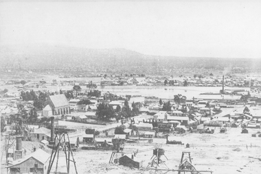
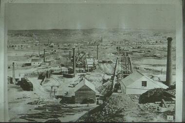
Photograph, St. Patrick’s Catholic Church
... . on the back is written "Stawell from Big Hill c 1880" ... "Stawell from Big Hill c 1880" Sepia photograph of St Patrick's ...St. Patrick’s Catholic Church and surrounding buildings 1880's. The church was opened in 1873. The construction is of Black Ranges faced with Grampians Freestone. The bell tower is 70 feet high, and the walls are 30 inches thick. The church was opened on 30th March 1873 by the Bishop of Melbourne, the Right Reverend Dr. Goold. The Historical Society have a programme for this opening - tickets for front seats were 10/- each. The sanctuary was added during 1927 as was a white marble altar which was the gift of a parishioner. Much earlier - In 1865 - a wooden Catholic Church was built on this street near the Court House site. The wooden building became too small for the congregation and this church was commenced before the end of 1869. Sepia photograph of St Patrick's Catholic Church and surrounding buildings. The photo also shows mining operations in Stawell with the Grampians in the background c 1880's. Two enlargements of the Catholic Church are taken from the sepia photograph and marked as 105a.C. Herbert. Photo. Copyright Registered Stawell. on the back is written "Stawell from Big Hill c 1880" stawell, panorama, mining -
 Lorne Historical Society
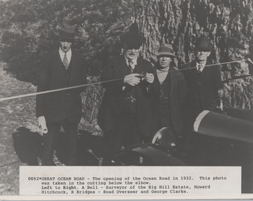
Photograph, Opening of Great Ocean Road by Howard Hitchcock 1932
... GOR opening 1932. A. Bell Surveyor. Big Hill Estate.... A. Bell Surveyor. Big Hill Estate. Howard Hitchock. George Clarke ...A. Bell, surveyor,Photograph of Opening of Great Ocean Road 1932 by Howard Hitchcockgor opening 1932. a. bell surveyor. big hill estate. howard hitchock. george clarke -
 Lorne Historical Society
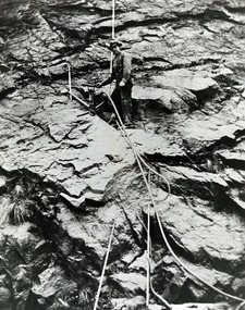
Photograph - Photograph of worker on rock face Great Ocean Road, Worker on rock face on Great Ocean Road
... G.O.R.; Big-Hill; Circa-1921; workmen; pneumatic-drill;... Parade Lorne great-ocean-road G.O.R.; Big-Hill; Circa-1921 ...photograph of workmen using ropes for pneumatic drill, ready to insert explosives into cliff face. Circa 1921g.o.r.; big-hill; circa-1921; workmen; pneumatic-drill; -
 Federation University Historical Collection
Report, Datab Pty Ltd, A Regional Tourism Development and Promotion Strategy for the Stawell and Halls Gap Area, 1995, 1995
... big hill... stawell halls gap dunkeld big hill great western winery village ...A report of the the Stawell and Halls Gap tourism area.Notes in pencil by Mary Hollick, lecturer in Tourism at the University of Ballarat.victorian tourisim industry, tourism, goldfields, victorian goldfields, stawell, halls gap, dunkeld, big hill, great western winery village, brambuk living cultural centre, grampians art gallery, built heritage -
 Bendigo Historical Society Inc.
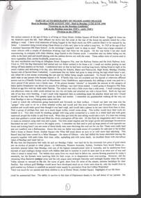
Document - ''THE CONSTRUCTION: OF THE MELBOURNE TO BENDIGO RAILWAY'' P.1
... Big Hill Tunnel... Taradale Viaduct Coliban River Elphinstone Tunnel Big Hill Tunnel ...''The Construction of the Melbourne to Bendigo Railway' pages 1 and 2 (separate sheets) of a document (laminated) prepared by the Bendigo Historical Society and outlining the history of the construction of the line..Bendigo Historical Societybendigo, history, bendigo railway, construction of the melbourne to bendigo rail line. mr valintine, mr lysaght, dr backhaus, mr bissell, mr harney, dr hunt , mr mackay, cornish & bruce, malmsbury viaduct, taradale viaduct, coliban river, elphinstone tunnel, big hill tunnel, sir henry barkly, mr robert burrowes. -
 Bendigo Historical Society Inc.
Document - AUTOBIOGRAPHY OF NELSON JAMES MEAGER, 1980
... Big Hill Ranges... Abattoirs Kangaroo Flat State School Coliban Watershed Big Hill ...Autobiography of Nelson James Meager (1925-1998) Born and died in Bendigo: ''Growing up on the Bendigo Goldfields'' - written in the 1980s. 14 page document donated by Edith Lunn.person, individual, nelson james meager, chum street, fogitt & jones abattoirs, kangaroo flat state school, coliban watershed, big hill ranges, mt hetrbert, golden square state school, whip & jesery mine, forbes carshalton mine, 3 bo bendigo, st marks anglican church, rowes hill (allingham street), spring gully reservior, bendigo mines ltd, napoleon mine, mr fisher, st marks, g. j. coles, mr john curtin, raggart's bakery. -
 Bendigo Historical Society Inc.
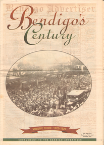
Newspaper - LONG GULLY HISTORY GROUP COLLECTION: BENDIGO'S CENTURY VOLUME THREE: 1920 - 1929
... Big Hill Tunnel... Square Big Hill Tunnel Bendigo Football League Bendigo United ...Newspaper supplement titled Bendigo's Century Volume Three: 1920 - 1929. Front page has a photo of The Duke and Duchess of York visit to Bendigo, 1927. Each year has heading of Who's Who, Weather, Sport and Business. First years are 1910 - 1919 titled The way we were. 1920 is titled Prince hailed. 1921 - City racks up a milestone. 1922 - Furore erupts. 1923 - Felons escape from city gaol. 1924 - Bid to finish RSL memorial. 1925 - Foul odour over sewerage plan. 1926 - Lest we forget Bendigo's fallen. 1927 - Royal Visit captures city. 1928 - Four shot in farm tragedy. 1929 - Billie's trip to remember.bendigo, history, long gully history group, the long gully history group - bendigo's century - volume three: 1920 - 1929, bendigo advertiser, duke and duchess of york, cr e m vains, r putnam, a j taylor, j h jackson, w crowley, sandhurst football club, george lansell, st peter's church, bendigo junior technical school, prince of wales, unity mine, mr w wilson, badak tin mining syndicate, mr t w ortonmr h scarborough, mr raleigh, general sir w r birdwood, the soldiers' memorial committee, bendigo city council, rsl memorial hall, captain g c wilson, lietenant r j parer, lieutenant j c mcintosh, cr j p carolin, h k morris, e a morris, turf tavern hotel, rev donald baker, all saints' pro--cathedral, keck's nursery, bendigo amalgamated goldfields, rising sun hotel, leanne mcdonnell, most rev john mccarthy, sir john quick, prime minister billy hughes, state rivers and water supply commission, diptheria, edna stevens, bendigo railway workshops, watson sustenance fund, sir joseph cook, dr lanza, bendigo amalgamated goldfields, bendigo benevolent asylum, miner's phthisis, bendigo gas company, electric light company, bendigo sewerage authority, commonwealth bank, cr curnow, the earl of stradbroke, dame nellie melba, princess theatre, lt-col g hurry, h sw lawson, countess of stradbroke, clunes woollen mills, girton college, mrs polglaise, mrs kennedy, gold discovery memorial, cr m g giudice, victorian co-operative freezing company, bendigo brick and tile company, mr lawson, soldiers' memorial, windermere hotel, toni riley pharmacy, bendigo gaol, mr a a dunstan mla, new red white and blue mine, claude de vere, walter osborne, sir john and lady quick, jonathan smalley, bendigo advertiser, st paul's bells, mr t cambridge, epsom public hall, bendigo school of mines, major lansell, mr h s w lawson, cr david andrew, colonel hurry, mr s bruce, bendigo sewerage authority, eppalock weir scheme, bendigo football league, r s l memorial, major g v lansell, lempriere, mr s m bruce, sandhurst hotel, market square, big hill tunnel, bendigo football league, bendigo united cricket club, south bendigo rex, sacred heart cathedral, hercules mine, gillies, aids & appliance shop, anne caudle centre, fizelle & mulqueen, south new moon mine, bendigo sewerage authority, mr a a kelley, epsom sewerage works, white hills botanical gardens, mr j sternberg mlc, bendigo book of remembrance, bendigo football league, senator general drake-brockman, captain dyett, school of mines, handschin and romus, hanro (aust.) bendigo knitting mills, charles handschin, farmers' union, andrew sunstan mla, country progressive party, john allan, captain g j c dyett, eahlehawk ufs dispensary, data fundamentals, the duke and duchess of york, the hercules mine, cr j a michelsen, lansell family, bendigo agricultural society, huntly shire council, bendigo creek trust, south african war memorial, cr j h curnow, st paul's church of england diamond jubilee, bendigo chamber of commerce, bendigo freezing works, bendigo pottery, bendigo trotting club, new red white and blue mine, the conservatory, cr e g batchelder, hercules mine, billie rigby, bendigo railway station, travellers' aid society, eppalock weir, the state rivers and water supply commission, bendigo railway workshops, frank grove, cr curnow, electric supply company, state electricity commission, australian aero club, bendigo preserving company, jardine, busbridge, feeman, mr h pearce, bfl, fred wood -
 Stawell Historical Society Inc
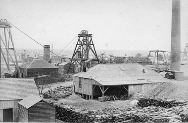
Photograph, Sloanes & Scotchmans Mine
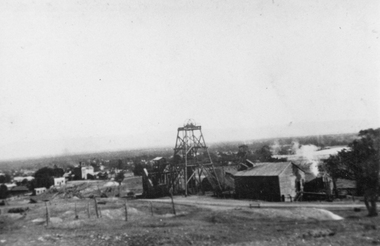
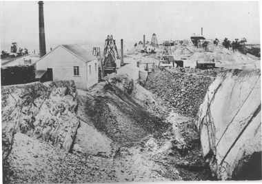
... Mine taken from Big Hill Facing North West. c 1915 to 1920... of Sloane & Scotchmans United Mine taken from Big Hill Facing North ...Poppet Head and Engine House of Sloane & Scotchmans United Mine taken from Big Hill Facing North West. c 1915 to 1920mining, panorama, gold -
 Bendigo Historical Society Inc.
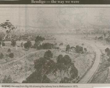
Newspaper - JENNY FOLEY COLLECTION: SCENIC
... : the view from Big Hill showing the railway line to Melbourne... ''the way we were'' from 2000. Scenic: the view from Big Hill ...Bendigo Advertiser ''the way we were'' from 2000. Scenic: the view from Big Hill showing the railway line to Melbourne in 1875. The clip is in a folder.newspaper, bendigo advertiser, the way we were -
 Bendigo Historical Society Inc.
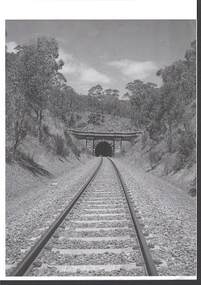
Photograph - RAILWAYS COLLECTION: RAILWAY TUNNEL SINGLE LINE
... to a Railway Tunnel (appears to be the Big Hill Tunnel) single line... of the entrance to a Railway Tunnel (appears to be the Big Hill Tunnel ...RAILWAYS COLLECTION -black and white Photo of the entrance to a Railway Tunnel (appears to be the Big Hill Tunnel) single line -writing on the back states -North Side.photograph, landscape -
 Bendigo Historical Society Inc.
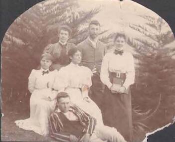
Photograph - BUICK COLLECTION: PHOTOGRAPH OF BUICK FAMILY AND FRIENDS
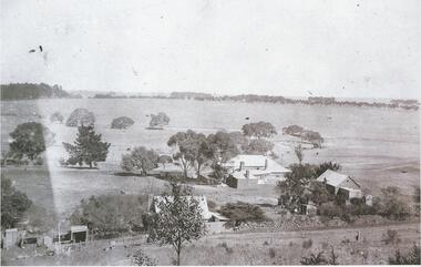
... . The Grange, Big Hill... standing. Inscribed : Lila and Agnes & friends. The Grange, Big ...Group photo in garden setting - one male standing; one male reclining. Four women standing. Inscribed : Lila and Agnes & friends. The Grange, Big Hillperson, group, buick family collection -
 Bendigo Historical Society Inc.
Photograph - LANSELL'S BIG 180 MINE - PHOTOGRAPH OF LANSELL'S BIG 180 MINE
... Photo of Lansell's Big 180 Victoria Hill - early 1870's...Lansell's big 180 Victoria Hill early 1870s... 180 Victoria Hill early 1870s Photo of Lansell's Big 180 ...Photo of Lansell's Big 180 Victoria Hill - early 1870's. In the background is New Chum Hill. In the right foreground is Ballerstedt's second Open cut. On the left edge of the opencut is a building with a chimney beside it and poppet legs and a chimney further behind the building. Behind the opencut are more chimneys, poppet legs and buildings. Two photocopies donated by A Richardson in Folder 124 (3556.1).Lansell's big 180 Victoria Hill early 1870sphoto, lansell's big 180 mine, new chum victoria, nth old chum, old chum, ballerstedt's 2nd opencut, a richardson -
 Bendigo Historical Society Inc.
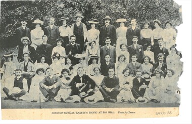
Document - HAMILTON COLLECTION: NEWSPAPER PHOTOGRAPH, Early 1900s
... Picnic at Big Hill''. Photo by Tasma.... of ''Bendigo Musical Society's Picnic at Big Hill''. Photo by Tasma ...Document. Photograph cut (Three sides) and torn (one side) from a newspaper. B&W Photograph of ''Bendigo Musical Society's Picnic at Big Hill''. Photo by Tasma.performing arts, elocution, newspaper. -
 Bendigo Historical Society Inc.
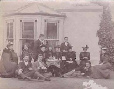
Photograph - BUICK COLLECTION: PHOTOGRAPH OF THE BUICK FAMILY/THE GRANGE?
... ; two sitting and one reclining . Taken at The Grange, Big Hill??... . Taken at The Grange, Big Hill?? Photograph BUICK COLLECTION ...Photograph of group (Buick family/friends?) in garden outside bay window; tea being served. Five males; eight females; two sitting and one reclining . Taken at The Grange, Big Hill??person, group, buick family collection -
 Bendigo Historical Society Inc.
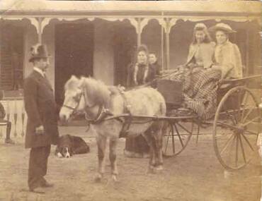
Photograph - BUICK COLLECTION: PHOTOGRAPH OF THE BUICK FAMILY?
... in background (The Grange, Big Hill??)... in front of pony. House verandah in background (The Grange, Big ...Photo with no inscription. Two young women in pony driven jinker (Buick daughters??) with two females in background and top-hatted and suited man in front of pony. House verandah in background (The Grange, Big Hill??)person, group, buick family collection -
 Bendigo Historical Society Inc.
Slide - ALBERT RICHARDSON COLLECTION: NEW CHUM HILL EARLY 1870'S
... Slide: View from New Chum Hill looking south towards Big... looking south towards Big Hill range. Poppet heads, mine buildings ...Slide: View from New Chum Hill looking south towards Big Hill range. Poppet heads, mine buildings, eight chimney stacks and mullock heaps. Image taken in early 1870's.No. 4 on bottom of slidemine, gold, new chum hill view(south)., bendigo mines-jack hattam collection -
Stawell Historical Society Inc
Archive - Plan, Stawell Water Supply, Stawell Water Supply Plan and Section of Valve House, c 1878
... Part of Infrastructure on Big Hill For Stawell Water Supply ... grampians Part of Infrastructure on Big Hill For Stawell Water ...Part of Infrastructure on Big Hill For Stawell Water Supply Large Technical drawing of Piping Significant Tears and Sections MissingScale 4 ft to 1 inch -
Stawell Historical Society Inc
Archive - Plan, Stawell Water Supply, Stawell Water Supply Detail Drawing of Valve House, c 1878
... Part of Infrastructure on Big Hill For Stawell Water Supply ... grampians Part of Infrastructure on Big Hill For Stawell Water ...Part of Infrastructure on Big Hill For Stawell Water Supply Large Technical drawing with some colouring. Torn on right hand sideScale 2 ft to 1 inch -
Stawell Historical Society Inc
Archive - Plan, Stawell Water Supply, Detail Drawings of Section of Culvert Pipes Stawell Water Supply, c 1878
... Part of Infrastructure on Big Hill For Stawell Water Supply ... grampians Part of Infrastructure on Big Hill For Stawell Water ...Part of Infrastructure on Big Hill For Stawell Water Supply Large Section Technical drawingsScale 2 ft to 1 inch -
 Stawell Historical Society Inc
Photograph, Scotchmans United Quartz Mining Company Scene c1890's. Same as 2640
... Stawell Mining Scene from Big Hill. Close up view... Stawell Mining Scene from Big Hill. Close up view of the winding ...Scotchmans United Quartz Mining Company Shaft was 1,018 feet deep.Stawell Mining Scene from Big Hill. Close up view of the winding engine shed Poppet Head and Building Scotchman's United Mine. Rear poppet head Crown Cross. Upper Main Street visible left Back of Photo. Stawell 176 Miles from Melbournemining, panorama -
 Stawell Historical Society Inc
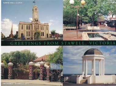
Postcard, postcard with 4 views of stawell
... Town Hall Stawell, Gold Reef Mall, Central Park Gates, Big... grampians Town Hall Stawell, Gold Reef Mall, Central Park Gates, Big ...Town Hall Stawell, Gold Reef Mall, Central Park Gates, Big Hill MemorialPostcard showing four views of StawellStawellstawell -
 Stawell Historical Society Inc
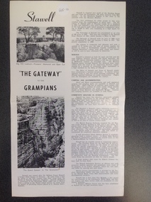
Book, Stawell "The Gateway to the Grampians", 1988
... on Big Hill. " "The Gateway" to the Grampians" above the other..." with Two photographs showing Pioneer's Lookout on Big Hill ...Stawell Tourist InformationA Page folded in half to make 4 pages with large print and small print split into two columns as well as two photographs on the right side"Stawell" with Two photographs showing Pioneer's Lookout on Big Hill. " "The Gateway" to the Grampians" above the other Photograph which shows a rock formation known as The Grand Canyon. which is located in the Grampians.stawell tourism -
 Stawell Historical Society Inc
Photograph, Tram Track -- 2 Photos -- Coloured
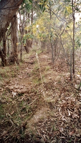
... Two colour photographs taken on Big Hill 1999 of the old... grampians Two colour photographs taken on Big Hill 1999 of the old ...Two colour photographs taken on Big Hill 1999 of the old tram track. Shows the track and bush.Two coloured photographs in bush setting. -
Bendigo Historical Society Inc.
Administrative record - Golden Carshalton N.L. Share Register, 1947 - 1951
... Golden Carshalton N.L. was formerly Big Hill North N.L...Golden Carshalton N.L. was formerly Big Hill North N.L ...Golden Carshalton N.L. was formerly Big Hill North N.L. states that Mr. J.H. Cahill who was formerly Maroon hard cover 'application for allotment' journal contained in a 'Kalamazoo binder'. Shareholder details entered on individual pages, in alphabetical order in journal. Date of entries range from 1947 to 1951. Inserted in journal: 'Golden Carshalton, N.L. Director's Report for the year ended 31st December 1949'; notice of ordinary general meeting of shareholders to b held on Wednesday 8th March, 1950 at Commonwealth Bank Chambers, J.J. Stanistreet, (McColl, Rankin and Stanistreet, Manager) On back of sheet is listed the 'working account and balance sheet for year ended 31st December 1949 . Register is part of the Margaret Roberts Collection of mining records. bendigo, margaret roberts, goldmining, golden carshalton n.l., share register, share allotment -
 Stawell Historical Society Inc
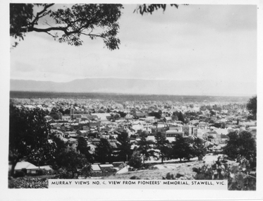
Photograph, Panorama of Stawell from Pioneers Memorial. Murray Views No. 4
... Panorama of Stawell from Big Hill. Murray Views No. 4...Panorama of Stawell from Big Hill. Murray Views No. 4 ...Panorama of Stawell from Big Hill. Murray Views No. 4. View from Pioneer Memorial Post c 1939Black & White photo of Stawell from Pioneers Memorial post c 1939. Murray Views No. 4, View from Pioneer's Memorial Stawell, Vic.stawell, panorama -
 Stawell Historical Society Inc
Photograph, Wonga, 16/04/1999
... on reverse of 7083 Wonga. 7093a Big hill fertilized by oil... Wonga. 7093a Big hill fertilized by oil and carbon particles ...7083b , 7083c, 7083d: Wonga7 Colour Photographs showing view of and aroud wonga open cuton reverse of 7083 Wonga. 7093a Big hill fertilized by oil and carbon particles from th edepths of the Stawell Gold mine, combed by the trees and the finer particles drift over the crystal waters of the reservior.mining -
 Lake Bolac & District Historical Society
Black and white photograph, Wickliffe, c. 1900
... Wickliffe, circa 1900. From the Big Hill at the north end... Highway Lake Bolac grampians Wickliffe, circa 1900. From the Big ...Wickliffe, circa 1900. From the Big Hill at the north end of town looking west. Bluestone hotel centre right and Gales cottage. -
 Bendigo Historical Society Inc.
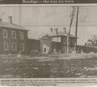
Newspaper - JENNY FOLEY COLLECTION: NEARING COMPLETION
... in 1861, Granite for the prison came from Big Hill... from Big Hill and the governor's residence was located behind ...Bendigo Advertiser ''The way we were'' from 2000. Bendigo goal is almost ready to open in this photo taken by Batchelder in 1861, Granite for the prison came from Big Hill and the governor's residence was located behind the trees to the right. (Photograph courtesy of the Bendigo Historical Society). The clip is in a folder.newspaper, bendigo advertiser, the way we were