Showing 4987 items
matching dandenong road.
-
 Ringwood and District Historical Society
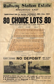
Flyer, Subdivisional Auction Sale Brochure, Railway Station Estate, Ringwood East, Vic. - 1918
... Subdivision includes Mount Dandenong Road (incorrectly... Dandenong Road (incorrectly shown as White Horse Road), Dublin Road ...Advertisement for subdivisional auction sale of 80 residential allotments on Saturday, 21st December, 1918, including terms of sale, subdivision layout, and nearby location photographs.Subdivision includes Mount Dandenong Road (incorrectly shown as White Horse Road), Dublin Road, Freeman Street, Bona Street, and Patterson Street. Local Agent - J.B. McAlpin, Telephone Ringwood 7. -
 Melbourne Tram Museum
Negative - Set of 2, Travis Jeffrey, 10/06/1962 12:00:00 AM
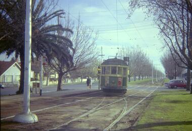
... Colour negative of tram 514 in Dandenong Road. Tram has... in Dandenong Road. Tram has destination Malvern - Burke Rd and Route ...Colour negative of tram 514 in Dandenong Road. Tram has destination Malvern - Burke Rd and Route No 5. Photo shows tram shunting. Note the newspaper box on the left hand side of the photograph. , Colour negative of tram 514 in Wattletree Road at Burke Rd terminus. Tram has destination City and Route No 5. Note thePaper folder that contained the negative had "NR77B" and date written as 10 Jun 62 in red ink., Paper folder that contained the negative had "NR76B" and date written as 10 Jun 62 in red ink.trams, tramways, w2 class, route 5, dandenong rd, wattle tree rd, malvern burke rd, tram 514 -
 Melbourne Tram Museum
Slide, Keith Caldwell, 16/03/1962 12:00:00 AM
... Caldwell March 1963 of W5 810 in bound in Dandenong Road Caulfield... Caldwell March 1963 of W5 810 in bound in Dandenong Road Caulfield ...Agfa colour slide, cardboard mount, photo by Keith Caldwell March 1963 of W5 810 in bound in Dandenong Road Caulfield showing St Kilda Junction, no route number followed by SW6 901 route 64 to the city. Shows the centre median strip. 810 has an advert for Ferris Car Radios and a second person in the cab."Dandenong Rd March 63" in blue ink.trams, tramways, st kilda junction, route 64, dandenong rd, sw6 class, w5 class, tram 901, tram 810 -
 Melbourne Tram Museum
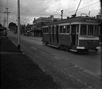
Photograph - Black & White Photograph/s, 1950's? to 1960's
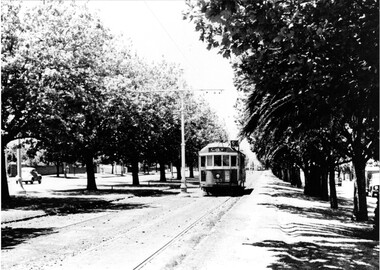
... Black and white photograph of W2 363 inbound, Dandenong..., Dandenong Road showing "City", route 5, possibly at the Hawthorn ...Black and white photograph of W2 363 inbound, Dandenong Road showing "City", route 5, possibly at the Hawthorn Road end - between Hawthorn and Kooyong Road, Malvern. Shows the many trees, centre poles and a few motor cars on the adjacent roadway. Printed on Fujichrome paper. Not known who took the photograph or when it was printed.Stamped in black ink on back "TMSV Sales"trams, tramways, dandenong rd, tram 363 -
 Ringwood and District Historical Society
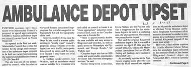
Newspaper, Newspaper articles on proposed ambulance depot in North Ringwood
... of Dublin and Mt Dandenong Roads...., is located at the corner of Dublin and Mt Dandenong Roads. Newspaper ...Proposed ambulance depot at 127-9 Oban Road, North Ringwood in 1995-6 but, due to protests, considered 8 Grey Street, East Ringwood. The ambulance depot, at 2021, is located at the corner of Dublin and Mt Dandenong Roads.Newspaper articles from Eastern Post and Ringwood Mail pasted on A4 sheets -
 Ringwood and District Historical Society
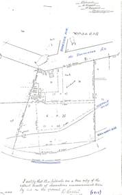
Document - Copy of Lands Department Field Notes - Subdivision of Ringwood, Victoria, Field Notes 1904/188 - Part of O.P. R72D Surveyed 28.4.1904
... notations. References include Mount Dandenong Road to Lilydale, M... Dandenong Road to Lilydale, M. Dickson (sold), Church of England, P ...Foolscap size photocopy of survey map with handwritten notations. References include Mount Dandenong Road to Lilydale, M. Dickson (sold), Church of England, P. Schonnenberger, Helen Lindsay, W.B. iron roof & shingles, I certify that this is a correct copy of the recorded observations and measurement made by me and my assistant (signed) W. Thorn 12/5/04 -
 Melbourne Tram Museum
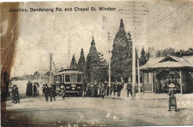
Postcard, "Junction, Dandenong Rd and Chapel St Windsor", c1910
... of Dandenong Road and Chapel St Windsor with many people either leaving... Postcard photo of PMTT tram 14 at the junction of Dandenong Road ...Postcard photo of PMTT tram 14 at the junction of Dandenong Road and Chapel St Windsor with many people either leaving or joining the tram. On the right hand side is a PMTT shelter with a number of people standing in it. Divided back with spaces for Correspondence, address and stamp. Stamp area has "Printed in county of Saxony" and number 3949 in bottom right hand corner.trams, tramways, pmtt, dandenong rd, chapel st, shelters, tram 14 -
 Melbourne Tram Museum
Negative, Wal Jack collection, c1944
... Beach, via Dandenong Road, Route 67) northbound in Hawthorn Road... Dandenong Road, Route 67) northbound in Hawthorn Road near ...Black and white negative, by Wal Jack?, of E 45 (St Kilda Beach, via Dandenong Road, Route 67) northbound in Hawthorn Road near intersection with Inkerman St. The building on the former remain in position. Advert for Turf Virginia Cigarettes. Photo not dated in the Wal Jack album. Possibly 14-9-42 based on other similar photos.trams, tramways, e class, hawthorn road, route 67, tram 45 -
 Ringwood and District Historical Society
Photograph-B&W, Joan Walker, East Ringwood 2000-East Ringwood Tennis Courts and the Cnr: Mount Dandenong & Dublin Roads, 2000
... : Mount Dandenong & Dublin Roads.- B&W Photo from Album 6501... Tennis Courts and the Cnr: Mount Dandenong & Dublin Roads.- B&W ...East Ringwood 2000-East Ringwood Tennis Courts and the Cnr: Mount Dandenong & Dublin Roads.- B&W Photo from Album 6501 -
 Ringwood and District Historical Society
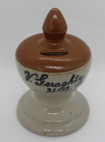
Ceramic - Money Box, Geraghty, Vincent, Pottery, handmade money box from Ringwood. 1914, 21-Dec-14
... Ringwood (corner of Federal and Mt Dandenong Roads)... of Federal and Mt Dandenong Roads) V. Geraghty - 21.12.14 Pottery ...Made by young Vincent Geraghty from clay from his father's Firebrick, Insulators & Pottery Company situated in East Ringwood. Vincent was one of a family of ten who were early settlers in East Ringwood (corner of Federal and Mt Dandenong Roads)Pottery, handmade money box. Grey base, brown top with coin slot and pointed top. Base includes black printing - F.I.& P. Co. of Ringwood. +Additional Keywords: Geraghty, Vincent / F. I. & P. Co. / Firebrick, Insulators and Pottery Co.V. Geraghty - 21.12.14 -
 Ringwood and District Historical Society
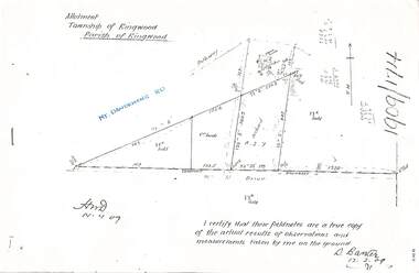
Document - Copy of Lands Department Field Notes - Parish of Ringwood, Victoria, Field Notes 1909/174 - Part of O.P. R72D surveyed 12.3.1909
... notations. References include Mount Dandenong Road, pathway, 2 room... Dandenong Road, pathway, 2 room house, scillion, shed, WC, 17C sold ...Foolscap size photocopy of survey map with handwritten notations. References include Mount Dandenong Road, pathway, 2 room house, scillion, shed, WC, 17C sold, Cr lands, orchard, 17E sold, Township boundary, I certify that these field notes are a true copy of the actual results of observations and measurements taken by me on the ground (signed) D. Barker 12.3.09. -
 Melbourne Tram Museum
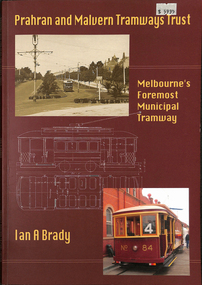
Book, Ian Brady, "Prahran and Malvern Tramways Trust - Melbourne's Foremost Municipal Tramway", 2011
... to the PMTT, its planning, construction, Alexander Cameron, Dandenong...Melbourne Tram Museum 8 Wallen Road Hawthorn melbourne ...Book - 96 pages + Card covers, perfect bound, titled "Prahran and Malvern Tramways Trust - Melbourne's Foremost Municipal Tramway", Ian Brady, published by Transit Australia Publishing, 2011. Has map and Table of contents, - background to the PMTT, its planning, construction, Alexander Cameron, Dandenong Road, Kew, Beach, tramcars, timetables, routes and personnel. Includes many photographs.trams, tramways, pmtt, transit australia, melbourne, new tramway, construction -
 Ringwood and District Historical Society
Photographs, Rebboch, Myil, Restaurants and cafes in Ringwood/Ringwood East photographed by Myil Rebboch - 1999-2000, 1999 - 2000
... Tavern - Mt Dandenong Road opposite Carcoola Road (3211_Nikos... (3211_Kublai_003) Nikos Greek Tavern - Mt Dandenong Road opposite Carcoola ...Bundle of 21 photographs in Agfa folder. Restaurants and cafes in Ringwood/Ringwood East 1999 - 2000. Taken by Myil Rebboch. Smorgy's - corner of Oban Road and Maroondah Highway (3211_Smorgy's_001) Red Rooster - corner of Beaufort Road and Maroondah Highway (3211_Red Rooster_002) Kublai Mongolian - corner of Beaufort Road and Maroondah Highway (3211_Kublai_003) Nikos Greek Tavern - Mt Dandenong Road opposite Carcoola Road (3211_Nikos Greek Tavern_004) Turtle Den - Railway Avenue Ringwood East (3211_Turtle Den_005) Maroondah Sporting Club - Mt Dandenong Road (3211_Maroondah Sporting Club_006) Hungry Jack's - corner of Mt Dandenong Road and Maroondah Highway (3211_Hungry Jack's_007) Daisey's Hotel - Mt Dandenong Road (3211_Daisey's Hotel_008) Lone Star - Maroondah Highway (3211_Lone Star_009) Canton - Murray Place (3211_Canton_010) Cafe Thirty-Five - Ringwood Street (3211_Cafe Thirty-Five_011) Cafe Ringwood Market (3211_Cafe Ringwood Market_012) Phoolwari - Eastland (3211_Phoolwari_013) Jamaica Blue - Eastland (3211_Jamaica Blue_014) Gourmet - Eastland (3211_Gourmet_015) Muffin Break - Eastland (3211_Muffin Break_016) Food Terrace - Eastland (3211_Food Terrace_017) Croissant - Eastland (3211_Croissant_018) Emerald Hill - Eastland (3211_Emerald Hill_019) Fasta Pasta - Eastland (3211_Fasta Pasta_020) Eating In - Eastland (3211_Eating In_021) -
 City of Kingston
Photograph - Digital image, July 1939
... Gartside on their property located on Centre Dandenong Road... Gartside on their property located on Centre Dandenong Road ...Kathleen Gartside with a cabbage grown by her father Jack Gartside on their property located on Centre Dandenong Road, Dingley. The Gartside family home was located opposite the Kingswood Golf Club in Dingley. The cabbage has a circumference of 12 feet, whilst the cabbage heart has a circumference of four feet. The Gartside family were a prominent local Dingley family, owning large market gardens and operating Gartside Bros Pty Ltd, a straight vegetable cannery employing large numbers of people. They were also keen golfers and around 1937, they leased 126 acres of their land to the Kingswood Golf Club. Jack Gartside moved his family home to the other side of Centre Dandenong Road, so that the Kingswood Clubhouse could be built. The first official games were played at Kingswood in March 1937. Black and white image of a young girl standing behind a large cabbagemarket garden, dingley, kingswood golf club -
 City of Moorabbin Historical Society (Operating the Box Cottage Museum)
Photograph - Plateway (Wheelway) Steel, circa 1885
... was removed in 1930 and Centre Dandenong Road plateway was removed... side of a few main roads in the Shire of Moorabbin so... was removed in 1930 and Centre Dandenong Road plateway was removed ...By the later 1800s the dirt roads in the then out-lying areas of the City of Moorabbin became dangerous, and almost impassable due to huge potholes and muddy swampy areas. The heavily laden market gardener’s carts regularly broke axles and wheels, and horses foundered on their way to the Melbourne markets. Even worse, the heavier “iron maidens”, carrying their malodorous loads of sewage from Melbourne’s inner suburbs for dumping in the outlying areas of the City of Moorabbin, also got bogged in the mire. It was decided that a practical solution to this problem was to install a metal plateway on the side of the problematic roads. In about 1887 the Moorabbin Shire Centre Road, in the Brighton East area, two parallel metal rails were installed so that the wheels of carts could run along smoothly, the horse travelled in the filled, middle area between the rails. Point Nepean Road plateway was removed in 1930 and Centre Dandenong Road plateway was removed in 1934-35. The worn plateway along Centre Road, East Brighton (now known as Bentleigh), was gradually taken up in several pieces, commencing in the the1920s, when its condition deteriorated and it caused a hazard to bikes, pedestrians, motor-cycles and the few early cars. The early steel plateway, constructed by David Munro, and opened on 23rd March 1885 by Thomas Bent, was built along Nepean Highway, between Asling St. and Bay St. The Point Nepean Track was subsequently extended into Moorabbin with branches along Centre, Cumins, South, Wickham, and Keys Roads, the total length was 13 miles. In 1908-1909 plates were laid along Centre Dandenong Road to Ross Street Bentleigh This innovative solution proved successful and was used until gradually the main roads were upgraded, and motorised vehicles started to appear. Two parallel metal rails were installed in the right hand side of a few main roads in the Shire of Moorabbin so that the wheels of heavily-loaded market gardener's carts on their way to markets in Melbourne could run along smoothly. The horse pulling the carts travelled in the filled, middle area between the rails. The Steel Plateway was constructed by David Munro, and opened on 23rd March 1885 by Thomas Bent. The wheelway first only ran along Nepean Highway, but it soon extended from Centre Dandenong Road, along Nepean road to its junction with Chapel Street, St Kilda. Later branch lines were built along Centre Road, Bentleigh as far as Warrigal Road and, according to early photographs, along Wickham Road Moorabbin as well. This innovative solution proved successful and was used until gradually the main roads were upgraded, and motorised vehicles started to appear. There was a problem with the wheelway : there was only a single set of rails and this was established on the right-hand side of the Nepean Road, travelling towards the city. Traffic FROM the city travelled on the correct or left-hand side of the road. The exception to this rule was the malodorous iron-clads, heavily riveted iron carts, generally travelling in convoy, carrying several tons of human effluent out of Melbourne to be trenched-in in the sandy soil of the Moorabbin district. Moorabbin City Council donated and installed a small section of Plateway at Box Cottage Museum in 1984melbourne, brighton, moorabbin, roads, plateway, wheelway, transport, st kilda, bent thomas, munro david, market gardens, steelway, carts horse-drawn, iron maidens, point nepean track -
 Whitehorse Historical Society Inc.
Map, Burwood Highway, c1970
... Mitcham melbourne Dandenong Creek Morack Road Vermont South ...Enlarged aerial photo of area South of Burwood Highway to Dandenong Creek, Vermont South.Enlarged aerial photo of area South of Burwood Highway to Dandenong Creek, Vermont South.Enlarged aerial photo of area South of Burwood Highway to Dandenong Creek, Vermont South.dandenong creek, morack road, vermont south, burwood highway, vermont south, aerial photographs -
 Mt Dandenong & District Historical Society Inc.
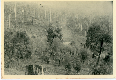
Photograph, Home of George Dodd at Olinda 1895, 1895
... Community Hall 42 Falls Road Mt Dandenong yarra-valley ...1895 picture of the home of George Dodd built c1880. Shows the Selector's Road made in the 1880s from Pig Lane in The Basin to the road in front of the Mt dandenong Hotel.The descriptive text on the reverse of this photograph was hand written by John Lundy-Clarke.1895 picture of the home of George Dodd built about 1880 showing the road the selectors made in the 1880s from Pig Lane to the main road in front of the present Mt Dandenong Hotel near the present end of the Basin-Olinda Road. It was never gazetted as a road as the Bruces objected to it and landslides in 1891 closed it temporarily and later landslides closed it permanently.george dodd, dodd, mt dandenong hotel, selector's road, road, pig lane -
 Mt Dandenong & District Historical Society Inc.
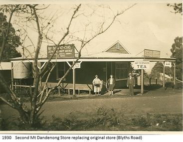
Photograph, Mt Dandenong Store, 1930
... Community Hall 42 Falls Road Mt Dandenong yarra-valley ...Image shows the Mt Dandenong Store and Post Office that replaced the former Post office and Store that was located on the corner of Old Coach and Farndons Roads. The store relocated following the opening of the new Main Road in 1926. The store pictured was on the corner of Helen Street and the Main Road. The image was taken in 1930. The photograph was taken by a member of the Dower family.Donated as a jpeg digital image that shows the Mt Dandenong Store on the corner of Helen Street and the Main Road in 1930. Two women and a man are standing at the front. Signs advertising the Store & Post Office, Age and Argus are clearly visible on top of the verandah.Front of image: 1930 Second Mt Dandenong Store replacing original store (Blyths Road)mt dandenong, post office, store, mt dandenong store, main road -
 Chelsea & District Historical Society Inc
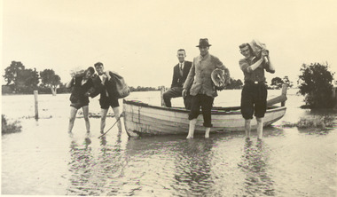
Photograph - Chelsea Flood December 1934, Delivering Food
... . flood chelsea Dandenong Creek Wells Road Black and white photo ...In December 1934, 700 houses were inundated with water, when the Dandenong Creek and Patterson River broke their banks.Black and white photo of five men in a life boat delivering rations to flood victims, landing at Wells Road. One of the men is Livock.flood, chelsea, dandenong creek, wells road -
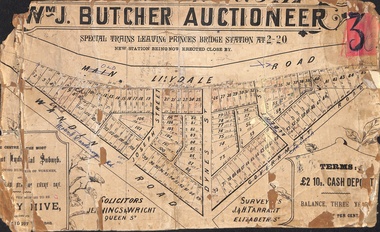 Ringwood and District Historical Society
Poster - Land Sale, Wm J. Butcher, Auctioneer - Albert Park Estate, Ringwood - c.1890
... Dandenong Road), Joseph Street, Dynes Street, Albert Street (later...), Wandin Road (later Mount Dandenong Road), Joseph Street, Dynes ...Central section of land sale subdivision advertisement glued to heavy cardboard backing. Photocopied SLV image of original advertisement shows map of 117 allotments for sale in Main Lilydale Road (later Old Lilydale Road), Wandin Road (later Mount Dandenong Road), Joseph Street, Dynes Street, Albert Street (later Wyrunga Street) and Government Road (later Carcoola Road), Ringwood East.Solicitors - Jenningw & Wright, Queen Street. Surveyors - J.&H. Tarrant, Elizabeth Street. Terms £2 10s cash deposit, balance three years at six per cent. -
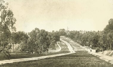 Ringwood and District Historical Society
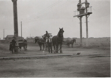
Photograph, Maroondah Highway East, Ringwood- 1900. Sandy Creek Bridge, Maroondah Hwy
... . To right of bridge is now Ringwood Lake. Mount Dandenong Road.... Mount Dandenong Road turnoff to right at top of rise ...3 photographs ( 2 large black and white, 1 small sepia)Written on all copies: "New Sandy Creek Bridge". Typed below large photograph: "Maroondah Highway Ringwood looking east. To right of bridge is now Ringwood Lake. Mount Dandenong Road turnoff to right at top of rise with antimony mine in background - 1900". -
Glen Eira Historical Society
Article - Toyne, Gilbert
... , manufacturer of the QUICK-DRY Rotary Clothes Hoist in Dandenong Road... in Dandenong Road. Envelope attached. Computer print-out on HUNG OUT ...This file contains two documents. Typewritten letter from Peter Cuffley providing background on Gilbert Toyne, manufacturer of the QUICK-DRY Rotary Clothes Hoist in Dandenong Road. Envelope attached. Computer print-out on HUNG OUT TO DRY the book, written by Peter Cuffley. Interview with him on ABC Ballarat Radio. Small black and white photo of hoist.toyne gilbert, quick dry rotary clothes hoist, toyne trading co., farrier, vernegie, ellimatta road, morton road, caulfield racecourse -
 Melbourne Tram Museum
Document - Research Notes, H. S. McComb, development and timing of the "PMTT" - part 5, 1950's
... Malvern, extension to Punt Road, Dandenong Road, Wattle Tree Road... to Punt Road, Dandenong Road, Wattle Tree Road, including its ...Set of papers, handwritten concerning the development and timing of the "PMTT", Prahran and Malvern - about 20 sheets. Prepared by H. S. McComb - gives layout of the PMTT system, primarily of Burke Road, sketches of track layout, opening dates, sketches of various junctions, bridges, track miles, junctions, reconciliation of track lengths from various sources includes High St Malvern, extension to Punt Road, Dandenong Road, Wattle Tree Road, including its duplication Items 2041 to 2052 within box 72.3 in a brown folder marked "PMTT" in red pencil.trams, tramways, pmtt, malvern, routes, track, surveys, wattle tree rd, punt rd, dandenong rd, high st, duplications -
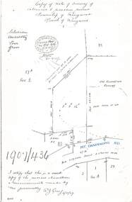 Ringwood and District Historical Society
Document - Copy of Lands Department Field Notes - Survey of Extension to Recreation Reserve, Township of Ringwood, Victoria, Field Notes 1907/436 - Part of O.P. R72D Surveyed 6.8.1907
... Dandenong Road), Silurian, undulating, poor grass, Corner cut off... Lilydale Road 3 chains wide (Mount Dandenong Road), Silurian ...Foolscap size photocopy of survey map with handwritten notations. References include New Lilydale Road 3 chains wide (Mount Dandenong Road), Silurian, undulating, poor grass, Corner cut off to allow for road in future subdivision, Old recreation reserve, (circled area) oval now in use, A. Gisler, I certify that this is a correct copy of the recorded observations & measurements made by me personally (signed) R.J. Gray 6/8/07. -
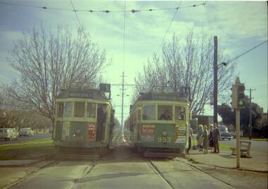 Melbourne Tram Museum
Negative, Travis Jeffrey, 10/06/1962 12:00:00 AM
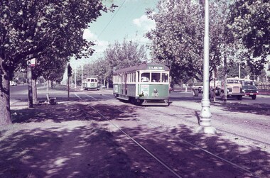
... Colour negative of trams 514 and 953 in Dandenong Road...Melbourne Tram Museum 8 Wallen Road Hawthorn melbourne ...Colour negative of trams 514 and 953 in Dandenong Road. Tram 514 has destination Malvern - Burke Rd and Route No 5. Photo shows tram on the left track (city-bound), although facing towards its destination (Malvern). Driver standing in door of cab and conductor standing in doorway to tram. Tram 953 has destination East Brighton via Caulfield and Route No 64. Sign on front states: "Connect with Malvern-Burke Rd tram".Paper folder that contained the negative had "NR75B" and date written as 10 Jun 62 in red ink.trams, tramways, w2 class, route 5, route 64, dandenong rd, wattle tree rd, malvern burke rd, tram 514, tram 953 -
 Jewish Museum of Australia
Chess set
... and ink 4) 313a Dandenong Road Windsor 3181 Victoria Australia Tel... and ink 4) 313a Dandenong Road Windsor 3181 Victoria Australia Tel ...This chess set was carved from local wood with bases made from halved cotton reels. The chess pieces take the shape of Australian animals, and Aboriginal men and women. The set was presented to Mr. Benzion Patkin, Honorary Secretary of the Zionist Federation of Australia, by Tatura internees in recognition of his assistance, in particular, his assistance in facilitating the emigration to Palestine. According to Mr. Patkin, he received the chess set in a wooden box inscribed, "With our sincerest thanks from your Zionist friends - Tatura, on the way to Eretz Israel, per Leonhard Levin, 20.11.1942.".Written in pencil UR corner, upside down: (22) Printed in black ink: "B. & H. PATKIN Flat (printed 2 corrected in pen and ink 4) 313a Dandenong Road Windsor 3181 Victoria Australia Tel: Home 51 - 5671 Bus 63 - 8959"dunera, wwii, internees, jewish history & people -
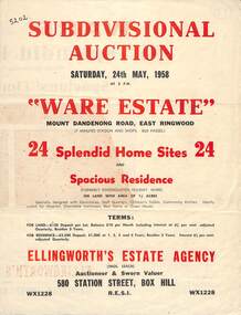 Ringwood and District Historical Society
Flyer, Subdivisional Auction Sale Brochure, Ware Estate, East Ringwood, Vic. - 1958
... Subdivision includes Mount Dandenong Road, Ware Crescent...Subdivision includes Mount Dandenong Road, Ware Crescent ...Folded double-sided advertisement for auction of 24 home sites and existing residence on Saturday, 24th May, 1958, including locality map, subdivision layout, terms of sale, and summary of local facilities and services. Additional plan of lots 28-33 dated 26/10/60 by Licensed Surveyor for Kirkpatrick & Webber, 225 Maroondah Highway Ringwood headed Plan of Subdivision of part of Crown Allotment 26A Parish of Ringwood.Subdivision includes Mount Dandenong Road, Ware Crescent, Davey Drive, and Grey Road (later Grey Street). Timber residence included in the subdivision was formerly Ware Kindergarten Holiday Home. (Agent) Ellingworth's Estate Agency, 580 Station Street, Box Hill - (Phone) WX1228. -
 Whitehorse Historical Society Inc.
Photograph - Black and white photograph, Boronia Road, Vermont
... Boronia Road Vermont approaching Dandenong Creek....Black and white photo of Boronia Road approaching Dandenong... Mitcham melbourne Boronia Road Vermont approaching Dandenong Creek ...Boronia Road Vermont approaching Dandenong Creek.Black and white photo of Boronia Road approaching Dandenong Creek, Vermontboronia road vermont, dandenong creek -
 Ringwood and District Historical Society
Document - Copy of Lands Department Field Notes - Parish of Ringwood, Victoria, Field Notes - OP34838 - surveyed in 1919 by D. Barker
... Dandenong Road, Rosedale Court, Railway Avenue, cyclone fence, Sec... Braeside Avenue, Mount Dandenong Road, Rosedale Court, Railway ...5615b Foolscap size photocopy of survey map with handwritten notations. References include Braeside Avenue, Mount Dandenong Road, Rosedale Court, Railway Avenue, cyclone fence, Sec A, WB house, old tennis court netted, stable, old shed, tank stand, orchard, Township Boundary, netting fence, Railway fence, Ringwood to Lilydale Railway, I certify that these fieldnotes are a true copy of the actual results of observations & measurements taken by me on the ground (signed) D. Barker (1919). -
 Ringwood and District Historical Society
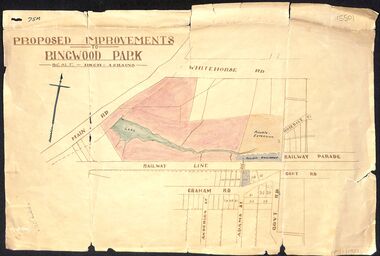
Map, Proposed Improvements to Ringwood Park (Ringwood Lake) dated 14 January 1927
... is Whitehorse Road (Maroondah Highway), and Mt Dandenong Road... Dandenong Road is incorrectly labelled Whitehorse Road. The map ...Proposed Improvements to Ringwood Park (Ringwood Lake) dated 14 January 1927, signed Cr McCaskill. Main Road is Whitehorse Road (Maroondah Highway), and Mt Dandenong Road is incorrectly labelled Whitehorse Road. The map shows Rosedale Crescent and Railway Parade, both of which exist in 2024. On the bottom of the map, south of the railway line, showing proposed streets - Graham Road, Anderson Street and Adams Street - in preparation for the sale of the Theo Anderson property. That area is now Bedford Park.