Showing 3432 items
matching distances
-
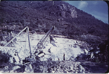 Halls Gap & Grampians Historical Society
Photograph - Coloured, 1955
Heatherlie QuarryHeatherlie Quarry - Photo shows 2 people standing in quarry. Machinery in foreground; rock-face middle distancequarrying, mt difficult quarry -
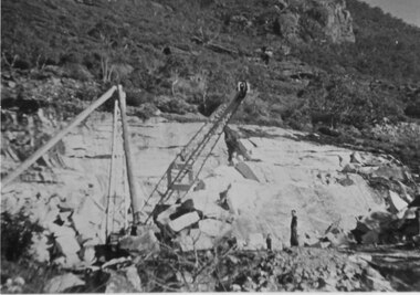 Halls Gap & Grampians Historical Society
Photograph - Coloured, 1955
Heatherlie QuarryHeatherlie Quarry - Photo shows 2 people standing in quarry. Machinery in foreground. Rock-face middle distancequarrying, rocklyn -
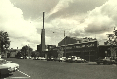 Federation University Historical Collection
Photograph - Black and White, Carlton and United Breweries Ballarat Plant, Lydiard Street South, Ballarat
Black and white photograph of the brewery in Lydiard Street South, Ballarat. The Ballarat Gaol gates can be seen in the distance.ballarat brewery, carlton and united breweries, chimney, ballarat gaol, ballarat gaol gates, lydiard street south, ballarat -
 Glenelg Shire Council Cultural Collection
Slide - Slide - Cashmore Airport, Portland, 1980s
portland airport, cashmore airport, construction, development, air travel -
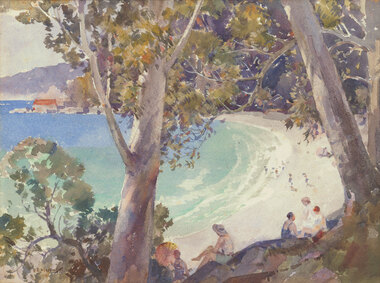 Benalla Art Gallery
Watercolour, B. E. MINNS, Bathers at the beach, 1935
Born: Dungog, New South Wales, Australia 1864; Lived and worked: England and France 1895-1915; Died: Taronga Park, New South Wales, Australia 1937InterwarLedger Gift, 1987Figures relaxing under trees overlooking beach with buildings and hills in the distance. Thin gold brushed timber frame.Recto: Signed and dated "B.E.MINNS / 1935" in brown watercolour in l.l.c of composition; Not titled watercolour, seascape, trees, figures, beach, buildings -
Tatura Irrigation & Wartime Camps Museum
Drawing - Drawing - Copy, Siegmund Lewinsohn
Sketch of fellow "Dunera" internee Siegmund Lewinsohn in Camp 2 by Robert Hofmann, former Austrian Court Painter. Photo emailed to Museum. Lewinshohn was born in Dautzig, Germany, Lewinsohn and was first interned at Hay NSW and then at Tatura. He enlisted in the Australian Army in the Employment Company (V503913) on 16 November 1942 at Royal Park, Victoria.Portrait of "Dunera" internee, Siegmund Lewinsohn. The Camp and its buildings, including the watch tower, can be seen in the distance. -
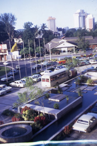 Robin Boyd Foundation
Slide, Robin Boyd, 1970
Robin Boyd travelled to Malaysia, Macau and Singapore in 1970, after a visit to Expo 70 in Osaka, where he was Exhibits Architect of the Australian Pavilion.Colour slide in a mount. Streetscene (Ming Court Hotel with yellow roof in the distance), Singapore (see also S0995)Made in Australia / 2 / MAY 70M3expo 70, osaka, robin boyd, slide -
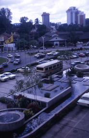 Robin Boyd Foundation
Slide, Robin Boyd, 1970
Robin Boyd travelled to Malaysia, Macau and Singapore in 1970, after a visit to Expo 70 in Osaka, where he was Exhibits Architect of the Australian Pavilion.Colour slide in a mount. Streetscene (The Ming Court Hotel with yellow roof in the distance), Singapore (see also S0959)Made in Australia / 37 / MAY 70M3expo 70, osaka, robin boyd, slide -
 Whitehorse Historical Society Inc.
Photograph, Station Street, Mitcham, 1/10/2000 12:00:00 AM
Coloured photograph of Station Street Mitcham looking north. Trees on Mitcham Mall (formerly Britannia Street) in distancestation street, mitcham, britannia mall mitcham, britannia street -
 Ballarat Heritage Services
Photograph - Photograph - Colour, Clare Gervasoni, Pedretti Homestead Ruins at Elevated Plains, Victoria, c1990, 22/04/1991
Martino Pedretti was born in Brusio, Switzerland.Four colour photographs of Martino Pedretti's farm, and the ruins of his drystone house. Mount Franklin (Lalgambook) in the distance.martino pedretti, elevated plains, dry diggings, drystone, mount franklin, lalgambook -
 Whitehorse Historical Society Inc.
Photograph, Brittania Mall Mitcham
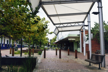
The Brittania Mall was part of a $5 million development of the Mitcham Shopping centre, begun in 1986. It affected both Edward Street and Brittania Street, part of which had to be re-routed. The guide hall in Brittania Street was removed to Halliday Park Mitcham. The development included extension of the New World Supermarket(now Coles) and a two level carpark.Coloured photograph of the Britannia Mall, Mitcham taken from the north end. Traffic in the distance is on Whitehorse Road - 2012shops, britannia mall, mitcham -
 South Gippsland Shire Council
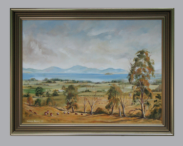
Framed oil painting, McDonalds Property Toora, 1983
Painted by Bianca Biesuz in 1983 The art work features cattle and trees in the foreground and Wilson's Promotory in the distance. Brown wood frame with gold edging. -
 Otway Districts Historical Society
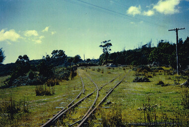
Photograph, Doug McLean, Crowes: station yard, 1960, 1960
In 1960 the Crowes railway station and yards had been closed for six years, since December 1954. This section was left to the elements, the line being rapidly covered with vegetation. This had to be cleared when rail recovery trains ran again to Crowes when the track was being pulled up in 1961.Colour. Crowes station yard in 1960; two tracks diverging from one. Not two cars in the middle distance. crowes; railway; -
 Kew Historical Society Inc
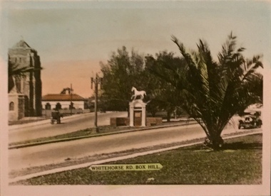
Postcard, Whitehorse Rd, Box Hill
One of a number of 'real photo' and commercial postcards created by or owned by members of the Christian and Washfold families of Kew. The postcards are part of a larger collection of photographs, postcards and publications donated to the collection in May 2021.Coloured matte postcard of Whitehorse statue. Palm tree in foreground, statue in middle ground and church (sic) in distance.whitehorse road -- box hill, postcards -- box hill, christian-washfold collection -
 Sunbury Family History and Heritage Society Inc.
Photograph, 1935
The waterfall is in Jacksons Creek downstream from the Sunbury township.A black and white photograph with a cream border of a waterfall in a river. A gnarled tree is growing on the bank and there is a hill in the middle distance.waterfalls, jacksons creek, sunbury -
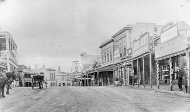 Stawell Historical Society Inc
Photograph, Upper Main Street Stawell looking East with on left the 2 story Allingham building & behind the cart is the Commercial Hotel c1910 -- 2 Photos -- 1 Colour
Upper Main Street Stawell. Looking East c1910. On left two story Allingham building behind cart is Commercial Hotel. Oriental Bank. Punchard Furniture. Crown Cross Poppet head visible on Big Hill. The side of the Mechanics Institute visible near centre. H S Dawson Chemist. Clarke & Scott Drapery on right. Same as 6730-1 & 2785View along upper Main Street looking East towards Big Hill. Poppet Head in distance at centre.stawell streetscape, mining -
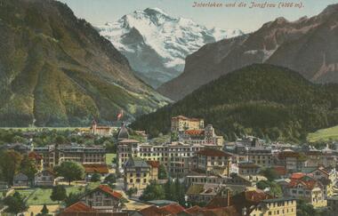 Bendigo Historical Society Inc.
Postcard - ROY AND DORIS KELLY COLLECTION: INTERLAKEN UND DIE JUNGFRAU (4166M), 1900-1920
Postcard, coloured photo of the Swiss city of Interlaken with the snow covered Jungfrau mountain in the distance. Height 4166 metres.postcard, photograph, postcard, interlaken, switzerland, jungfrau -
 Bendigo Historical Society Inc.
Postcard - ROY AND DORIS KELLY COLLECTION: MAINZ PANORAMA, GERMANY, 1900-1920
Postcard, coloured photo of a panoramic view of the city of Mainz in Germany. Showing the roofs of buildings and low hills in the distance.postcard, photograph, postcard, mainz, germany -
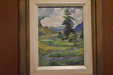 Tatura Irrigation & Wartime Camps Museum
Painting - Painting - Oil, Vagarini 1924, 1924
In the possession of internee at Camp 3.Oil painting of a hilly landscape with a lake in the distance and winding stream and fir tree centre right. Gold frameBottom right hand corner (in red) "Vagarini 1924"painting, oil, vagarini c, baer dr t, ww2 camps -
Linton Mechanics Institute and Free Library Collection
Book - Novel, Douglas, Bruce (Theodore Wayland Douglas), Border range, [n.d.] [1942?]
Western romantic fiction, in which protagonists battle to defend their land from marauders and gunmen.216 p. ; red cover with image of woman on horse, man walking beside her, cattle and cowboys in distance.fictionWestern romantic fiction, in which protagonists battle to defend their land from marauders and gunmen.westerns, fiction -
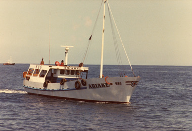 Lakes Entrance Historical Society
Photograph - Artake, 1980c
Colour photograph of the scallop fishing boat Artake at sea. Another fishing boat in distance. Lakes Entrance Victoriafishing industry, ships and shipping, waterways -
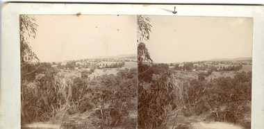 The Beechworth Burke Museum
Photograph - Stereoscopic Photograph
This photograph offers a view of Beechworth, located at the foot of the Victorian Alps. It captures the gorge and native vegetation in the foreground, with the Beechworth township visible in the middle, where the hospital is marked with an arrow. Distant hills form the backdrop. Originally settled c1839, Beechworth was officially proclaimed a town in 1856.This photograph is historically significant as it captures the landscape of Beechworth, providing valuable insight into the town's visual and historical character.Two sepia-toned square photographs showing the view of a town with trees in the foreground and hills in the far distance, mounted.Obervse: Above the right photograph there is an arrow pointing down. Reverse: 97.2195/ View across the Gorge/ looking over Beechworth/ (Hospital under arrow)/ 84-110-1/ A03082beechworth, town, landscape, ovens district, stereoscopic -
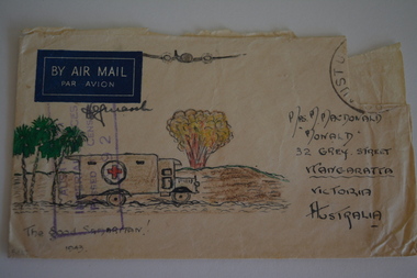 Wangaratta RSL Sub Branch
Work on paper - Envelope Art
One of several illustrated envelopes, without letter, sketched by soldier/s during the second world war and sent to Mrs MacDonald of WangarattaVictoria's 2/24th Infantry Battalion was raised in Wangaratta in July 1940. They were welcomed with open arms by the local community as they rapidly built up their numbers. The people of Wangaratta adopted the Battalion and they became known as "Wangaratta's Own" because of the time the battalion spent in the town during its formative period prior to deployment overseas. Many of the soldiers maintained life long friendships with the people of Wangaratta. Even though the Battation was disbanded in 1946 members and their families return each year, in November, for a commemorative service at the 2/24th Battalion Memorial Wall at the Wangaratta Cemetery.Cream paper envelope with coloured sketch of three palm trees an ambulance and plane overhead with bomb exploding in distance.Top left - BY AIR MAIL Top right - postage stamp Left side - AIF Censor stamp Right side - Mrs M MacDonald "Monald" 32 Grey Street Wangaratta Victoria Australia Bottom - "The good samaritan" 1943 ww2, envelope art -
 Lakes Entrance Historical Society
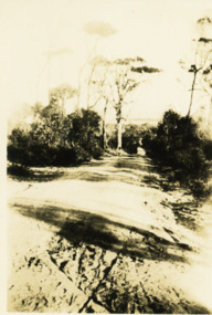
Photograph - Jemmys Point roadway, 1924
View of road down Jemmys Point, hummocks and lake just visible in far distance Lakes Entrance Victoriaroads and streets, topography -
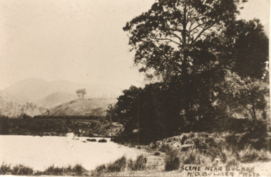 Lakes Entrance Historical Society
Postcard - Buchan Victoria, H D Bulmer, 1915 c
Sepia toned copy of postcard showing waterway with mountains in distance at Buchan Victoria. Also a second identical photographScene near Buchanagriculture, topography -
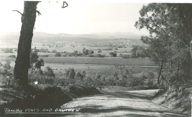 Lakes Entrance Historical Society
Photograph - Tambo River flats Bruthen Victoria, H D Bulmer, 1945 c
Black and white photograph of Tambo River flats and Bruthen in distance with maize crop growing on flats Bruthen Victoriafarming, agriculture, rivers -
 Eltham District Historical Society Inc
Negative - Photograph, View towards Main Road, Research from Maroondah Aqueduct Trail showing mudbrick manufacture, Research Industrial Estate, 1991
Eltham Little Theatre in centre distance and new housing estate development off Reynolds Road in distanceRoll of 35mm colour negative film, 9 strips Colour print 10 x 15 cmFuji HG 200 CA-1eltham little theatre, houses, main road, maroondah aqueduct, maroondah aqueduct trail, mudbrick, mudbrick construction, research (vic.), research industrial estate, reynolds road -
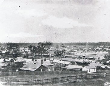 Bendigo Historical Society Inc.
Photograph - STREETSCAPE: BENDIGO, 1857 ?
Black and white photograph. View of Bendigo Many small buildings, weatherboard, stone, paling. Trees on horizon, Beehive stores in middle distance. Rough vertical stick fences, fencs in foreground. Taken from high ground. In image on parapet of building in middle distance ' Francis Brothers Beehive Stores'A. Fox ( James Lerk 11.2.2000 )place, streetscape, bendigo -
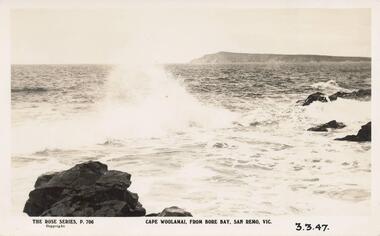 Phillip Island and District Historical Society Inc.
Photograph - Post Card, 1940's
One of 11 photographs left in the museum for the Society by an anonymous donor.Black & White postcard taken after coming under the San Remo - Newhaven Bridge. Shows Cape Woolamai in the distance.The Rose Series P 706 Cape Woolamai, from Bore Bay, San Remo, Vic. 3.3.47. On back: "Cape Woolamai in background, after coming under San Remo bridge. Cape Woolamai highest point on Phillip Island."cape woolamai, cape woolamai phillip island, bore bay san remo -
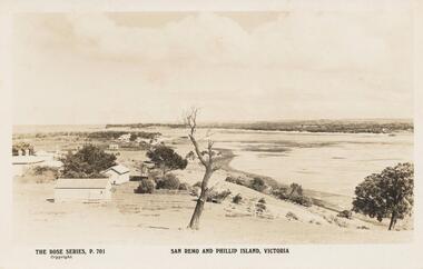 Phillip Island and District Historical Society Inc.
Sepia Photograph, 1920's
This album was presented to the Earl of Stradbroke by the Fathers of Soldiers and Returned Soldiers 16/02/1923Photograph of San Remo with early houses, possibly San Remo Hotel in the distance. Part of Phillip Island in back ground.Rose Series P701. San Remo and Phillip Island, Victoriaphillip island, san remo, earl of stradbroke, early houses