Showing 6845 items matching " gullies"
-
 Bendigo Historical Society Inc.
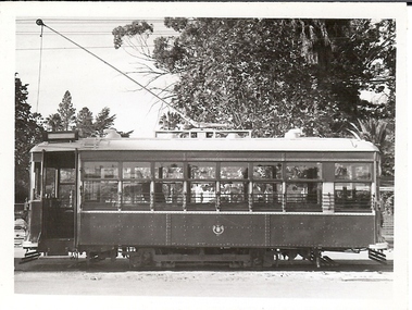
Photograph - BASIL MILLER COLLECTION: BURNIE SAFETY CAR
Black and white photo of Burnie Car stopped in front of Canterbury Park on Sailors Gully Road, Eaglehawk.person, individual, basil miller -
 Bendigo Historical Society Inc.
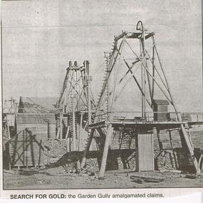
Newspaper - JENNY FOLEY COLLECTION: SEARCH FOR GOLD
Bendigo Advertiser "The way we were" from 1999. Search for gold: the Garden Gully amalgamated claims.newspaper, bendigo advertiser, the way we were -
 Southern Sherbrooke Historical Society Inc.
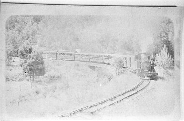
Photograph - Puffing Billy leaving Upper Ferntree Gully
Puffing Billy rounding a corner surrounded by grass and trees. Possibly near the bridge at Upper Ferntree Gully. -
 Bendigo Historical Society Inc.
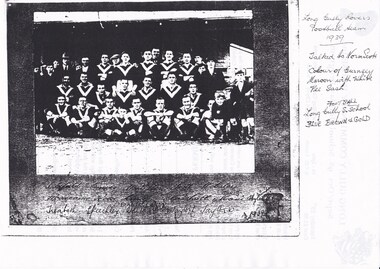
Photograph - LONG GULLY HISTORY GROUP COLLECTION: LONG GULLY ROVERS FOOTBALL TEAM 1939
Copy of a black and white photo of the Long Gully Rovers Football Team 1939. Photo very dark. Names written under the photo, most are unreadable. Some are Trenbath, Speechley, Taylor L and Taylor W? 1939. Written beside the photo is - Long Gully Rovers Football Team 1939. Talked to Norm Scott. Colour of Guernsey Maroon with White Vee Sash. Football Long Gully S. School Blue Brown & Gold.bendigo, history, long gully history group, the long gully history group - long gully rovers football team 1939, norm scott, trenbath, speechley, taylor l, taylor w? -
 Bendigo Historical Society Inc.
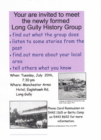
Document - LONG GULLY HISTORY GROUP COLLECTION: LONG GULLY HISTORY GROUP
BHS CollectionTwo two invitation flyers to meet the newly formed Long Gully History Group on 20th July (no year date) at the Manchester Arms Hotel, Eaglehawk Rd, Long Gully. One has a purple background on the top half of the page and the other is grey. There are two small photos: one is Looking up Eaglehawk Rd from the Long Gully Creek, approx 1870 and the other is a Bridal Party and Manchester Arms, circa 1900.bendigo, history, long gully history group, the long gully history group - long gully history group, manchestor arms hotel, carol rasmussen, betty camp -
 Bendigo Historical Society Inc.
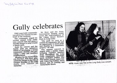
Document - LONG GULLY HISTORY GROUP COLLECTION: GULLY CELEBRATES 5 JUNE 99
Copy of a newspaper article titled Gully celebrates. The community staged its second annual Long Gully Live concert and was given a $20,00o cheque to help it building family park. Member for the North Western Province, Ron Best, presented the cheque to the City of Greater Bendigo at the Long Gully Live concert. He said the State Government funding would assist the redevelopment of the Chum Street Reserve Park in Long Gully. Entertainment included Golden City Pipe band, Zenyth, Anne Conway, Voice Pop Foibles, Steve Roscoe and Anonymous Bosch. Article includes a photo of two guitarists.bendigo, history, long gully history group, the long gully history group - gully celebrates, long gully live concert, ron best, city of greater bendigo, chum street reserve, golden city pipe band, zenyth, anne conway, voice pop foibles, steve roscoe, jo cowling, anonymous bosch -
 Eltham District Historical Society Inc
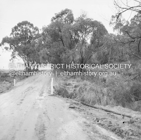
Negative - Photograph, J.A. McDonald, Healesville-Yarra Glen Road, c.1957
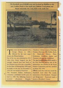
Bridge over Long GullyRecord of various Shire of Eltham infrastructure works undertaken during the period of 1952-1962 involving bridge and road reconstruction projects, sometimes with Eltham Shire Council Project Reference numbers quoted. It was during this period that a number of significant improvements were made to roads and new bridges constructed within the shire that remain in place as of present day (2022). In many situations, the photos provide a tangible visible record of infrastructure that existed throughout the early days of the Shire. The album was put together by or under the direction of the Shire Engineer, J.A. McDonald.infrastructure, shire of eltham, bridge construction, healesville-yarra glen road, 1957, long gully, healesville, long gully creek, old healesville road, jackson & dethridge, new zealand insurance co. ltd., public risk claim -
 Eltham District Historical Society Inc
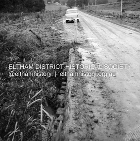
Negative - Photograph, J.A. McDonald, Healesville-Yarra Glen Road, c.1957
Bridge over Long GullyRecord of various Shire of Eltham infrastructure works undertaken during the period of 1952-1962 involving bridge and road reconstruction projects, sometimes with Eltham Shire Council Project Reference numbers quoted. It was during this period that a number of significant improvements were made to roads and new bridges constructed within the shire that remain in place as of present day (2022). In many situations, the photos provide a tangible visible record of infrastructure that existed throughout the early days of the Shire. The album was put together by or under the direction of the Shire Engineer, J.A. McDonald.infrastructure, shire of eltham, bridge construction, healesville-yarra glen road, 1957, long gully, healesville, long gully creek, old healesville road, jackson & dethridge, new zealand insurance co. ltd., public risk claim -
 Bendigo Historical Society Inc.
Newspaper - Newspaper articles - North Central Loddon Region
8375a: The Victorian soldier settlement scheme created in 1917 to lease farming land to soldiers and nurses returning from WW1. The Scheme was heavily criticised. Some reasons for this were the settlers' lack of capital, the size of the land allocated, and the prices of agricultural products both purchased and sold by the farmers. In the wake of WW2, the soldier settlement scheme was refined and, under the supervision of the Soldier Settlement Commission, was re-established. The Yarraberb Settlement was one of the settlements established in 1948. 8375b: Archibald Edmund "Archie" Robertson was born in Eaglehawk in 1884 to Martin Robertson and Anna Margaretha/Hannah Marguerita (nee. Weseloh/Wesloah). Robertson was a commissioned officer during WW1 and contributed to the welfare and advancement of the California Gully community. Following his death in 1922, following a fall from his bike, the community honoured Robertson with a memorial seat in 1923.A3 colour photocopies of newspaper articles pertaining to the North Central Victoria Region. Date of photocopy unknown. Location of original paper unknown (likely the Eaglehawk Times, unable to confirm). Both articles were cut from a larger paper. Article 8375a briefly describes the Yarraberb Solider Settlement. Article 8375b recounts the dedication of Archie Robertson's seat in California Gully. newspaper, eaglehawk heritage society, yarraberb soldiers settlement, soldier settlement commission, archie robertson, california gully, ww1, ww2 -
 Bendigo Historical Society Inc.
Document - MCCOLL, RANKIN AND STANISTREET COLLECTION: SHARE REGISTER GARDEN GULLY & MOON EXTENDED GOLD MINE
Share register journal Garden Gully and Moon extended Gold Mine. Green cover, buff spine and corners. Contains names and addresses of shareholders 1933 to 1934. Alphabetical list of shareholders in front of journal. Written on spine: Garden Gully Moon Extended Gold Mines NL.business, mining, garden gully and moon extended nl mines -
 Eltham District Historical Society Inc
Album - Photograph, J.A. McDonald, Healesville-Yarra Glen Road, Aug. 1958
Long Gully Bridge August 1958Record of various Shire of Eltham infrastructure works undertaken during the period of 1952-1962 involving bridge and road reconstruction projects, sometimes with Eltham Shire Council Project Reference numbers quoted. It was during this period that a number of significant improvements were made to roads and new bridges constructed within the shire that remain in place as of present day (2022). In many situations, the photos provide a tangible visible record of infrastructure that existed throughout the early days of the Shire. The album was put together by or under the direction of the Shire Engineer, J.A. McDonald.infrastructure, shire of eltham, 1958-08, bridge construction, long gully bridge, road construction -
 Clunes Museum
Education kit - DOCUMENT, SOIL CONSERVATION AUTHORITY, MCHUGH'S GULLY - A LAND USE AND MANAGEMENT TEACHING RESOURCE KIT, 1982
ENVIRONMENTAL STUDY OF MCHUGH'S GULLY RECORDED IN THE EARLY 1980'SBUFF COLOURED LEVER ARCH FILE CONTAINING SECTIONS A TO I WITH A CARDBOARD INSERT OF FRONT COVER WITH SEPIA IMAGES OF RURAL SCENES AND TOWN SHIP PRINTED ON IT. Section A contains documents of land use and management teaching resource kit. Section I contains slides and transparenciesnon-fictionENVIRONMENTAL STUDY OF MCHUGH'S GULLY RECORDED IN THE EARLY 1980'Smchughs gully, land management, environmental impact report -
 Federation University Historical Collection
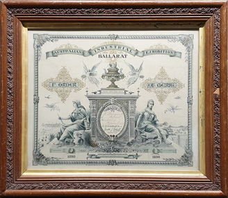
Certificate, Australian Juvenile Exhibition Ballarat Certificate, 1896, 1896
The certificate was designed by David Kent in 1896Timber framed certificate relating to the Australian Juvenile Exhibition Ballarat and awarded to William Baragwanath for the model of the Welcome Gully. Frame is by W.H. Burgoyne, Picture Frame Maker, artist, Castlemainecertificate, w.h. burgoyne, william baragwanath, c.b. retallack, joseph j. kelsall, david kent, rider and mercer -
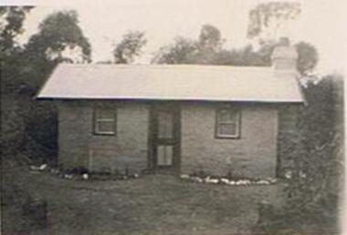 Bendigo Historical Society Inc.
Photograph - COOK COLLECTION : BENDIGO FIELD NATURALISTS CLUB - COTTAGE
Cottage. Photo, black and white. Inscriptions: back, E A Cook, 231 Carpenter Street, Spring Gully, Bendigo.buildings, house, cottage -
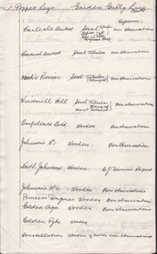 Bendigo Historical Society Inc.
Document - CARLISLE UNITED MINE - POPPET LEGS OF THE GARDEN GULLY LINE
Hand written notes on the poppet legs of the Garden Gully Line. Lists the mines and if the poppet legs are steel or wooden.mine, gold, carlisle, carlisle united mine, poppet legs of the garden gully line -
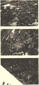 Bendigo Historical Society Inc.
Photograph - LONG GULLY HISTORY GROUP COLLECTION: AERIAL PHOTOS
Copies of three dark aerial photos of suburban areas, possibly Long Gully. Photos show streets and buildings.bendigo, history, long gully history group, the long gully history group - aerial photos -
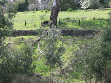 Victorian Interpretive Projects Inc.
Photograph - Colour, Clare Gervasoni, Drystone Wall, Hepburn Springs, 2006, 247/08/2006
Colour photograph showing a drystone wall along Doctor's Gully in Hepburn Springs. This land was associated with Vincenzo Perini.drystone, perini, doctor's gully, hepburn, hepburn springs -
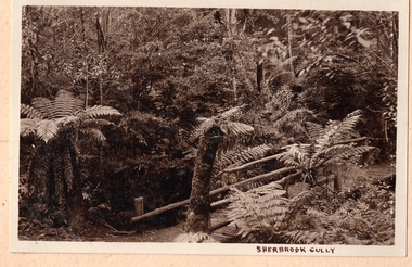 Southern Sherbrooke Historical Society Inc.
Photograph, Sherbrooke Gully
Fern gully in Sherbrooke Forest. A bridge with long log sides crosses a creek. Tree ferns edge the track. -
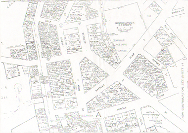 Bendigo Historical Society Inc.
Map - LONG GULLY HISTORY GROUP COLLECTION: LONG GULLY
Copy of a map of Long Gully area with some street names, size of allotments, number, measurements, date and names.bendigo, history, long gully history group, the long gully history group - long gully, housing commission, housing act 1958, gazette -
 National Vietnam Veterans Museum (NVVM)
Photograph
Black & white photograph of the Harold Holt Pool at Vung Tau.Sticker on back of photograph _ Alex M. Gall. 166 Forest Rd., Ferntree Gully, Vic. 3156harold holt pool -
 Friends of Kurth Kiln
Wooden Box
Rectangular Wooden Box made from 3plywood with reinforced corners and wire banding. Open at the topForest Comm. Victoria / Forest Officer T Wescott / Kallista / via / FernTree Gully / Rly Station -
 Bendigo Historical Society Inc.
Map - GUIDE MAP OF BENDIGO & EAGLEHAWK, Late 1920's
Map. Guide Map of Bendigo & Eaglehawk. Light brown coloured booklet containing folded map of Bendigo and Eaglehawk. Outer cover is printed in blue and red ink and states - With compliments of J H Curnow & Son, Auctioneers, Real Estate Agents, Farm & Dairy Produce Merchants, Bendigo. Printed by J B Young, Lithographer. Map shows tramways & bus routes. Map shows Agricultural Showgrounds located between Park Street, Water Street, Barnard Street and Bridge Lane. Also shows Acclimitization Reserve located behind The Botanical Gardens at White Hills. Shows the location of Sailors Gully, Peg-Leg Gully, Jobs Gully, California Gully, Long Gully, Ironbark Gully, Golden Gully, Poverty Gully, Sheepshead Gully, Charcoal Gully, Eaglehawk Creek, Bendigo Creek and Back Creek. Contains interesting facts about Bendigo - Area 7,900 acres. Population - 26,000. First Council elected - 1855. Proclaimed a Borough - 1863. Proclaimed a City - 1871. Gold Rush broke out - 1851. For first 10 years gold yield averaged 8,600 ozs. per week . Total gold yield to 1923 - 572 tons valued at 82,000,000 pounds. Deepest mines - Victoria Quartz 4,614 ft., New Chum Railway 4,318 ft. 13 mines over 3.000 ft. deep. 53 mines over 2,000 ft. deep. Sewering of City commenced 1922, all principal buildings now sewered. Map printed by Arnall & Jackson, General Printers, Stationers & Engravers, 476 Collins Street. Map displays advertisement for J H Curnow & Son, Bendigo's leading Auctioneer and Estate Agents, Mitchell & Queen Sts. Bendigo. Map Scale 20 chs. = 1 in.cottage, miners, guide map of bendigo and eaglehawk -
 Bendigo Historical Society Inc.
Map - GUIDE MAP OF BENDIGO & EAGLEHAWK, Late 1920's
Map. Guide map of Bendigo & Eaglehawk. Folded map of Bendigo & Eaglehawk with blue outer cover booklet. Map is compiled by E E Parker, Eaglehawk. Map shows tramways, bus routes and cost one shilling. Map shows Agricultural Showgrounds located between Park Street, Water Street, Barnard Street and Bridge Lane. Also shows Acclimitization Reserve located behind the Botanical Gardens at White Hills. Shows the location of Sailors Gully, Peg-Leg Gully, Jobs Gully, California Gully, Long Gully, Ironbark Gully, Golden Gully, Poverty Gully, Sheepshead Gully, Charcoal Gully, Eaglehawk Creek, Bendigo Creek and Back Creek.Contains interesting facts about Bendigo:- Area - 7,900 acres, Population - 26,000, First Council elected - 1855, Proclaimed a City - 1871. Gold Rush broke out - 1851. For first 10 years gold yield averaged 8,600 ozs. Per week. Total gold yield to 1923 - 572 tons valued at 82,000,000 pounds. Deepest mines - Victoria Quartz 4,614 ft., New Chum Railway 4,318 ft., 13 mines over 3,000ft. deep, 53 mines over 2,000 ft. deep. Sewering of City commenced 1922. All principal buildings now sewered. Map printed by Arnall & Jackson, General Printers, Stationers & Engravers, 476 Collins Street. Outer map blue cover printed in red and blue ink by J B Young, Lithographer. Map displays advertisement for Bendigo Timber Co. Outer blue cover displays advertisement for Campbell Connelly & Co. Pty. Ltd, Ironmongers, Timware Manufacturers, Plumbers, Sewerage Contractors, High and Forest Sts, Bendigo 9outside back cover) and for Hartleys ( J L Shoosmith) Bendigo, displaying Indian Motor Cycles (inside back cover).map, bendigo, township, guide map of bendigo & eaglehawk -
 Bendigo Historical Society Inc.
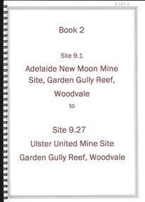
Book - ADELAIDE NEW MOON MINE GARDEN GULLY REEF WOODVALE TO ULSTER UNITED MINE SITE, WOODVALE, 1992
Book 2 - Site 9.1, Adelaide New Moon Mine site, Garden Gully Reef, Woodvale to site 9.27, Ulster United Mine Site, Garden Gully Reef, Woodvale. Book contains details of significance reports prepared for North Central Goldfields Project: Bendigo Goldfield.David Bannearbendigo, mining, goldfields report, bendigo, goldfields, gold, mining, reports, history -
 Bendigo Historical Society Inc.
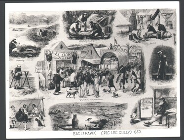
Photograph - WES HARRY COLLECTION: PEG - LEG GULLY, Original from 1852
Photograph of a montage of nine drawings depicting life during the first gold rush to Peg Leg Gully (Eaglehawk) during 1852. On the reverse in pencil is written ' Gold rush in Peg Leg Gully, The lightning rise and fall of an old gold town. A concise history of Australia, By Clive Turnbull.topic, mining, fist gold rush, gold rush, peg leg gully, eaglehawk -
Bendigo Historical Society Inc.
Booklet - Glittering Gullies
1. Dorothy Dempsey was a student of Arthur Thomas Woodward (see No.2). She was considered a "promising artist" who exhibited in Bendigo and Melbourne in the late 1930's - early 1940's. The Bendigo Art Gallery has one of her paintings. 2. Arthur Thomas Woodward (1865, Birmingham, England- 12/2/1943 Bendigo) Studied and taught art in England, Paris and Antwerp before coming to Victoria in 1889. Whilst briefly the Art Director of the Sale School of Art, he married Emma Jane Stokes in 1892. He then became the Head of the Art Department at the Bendigo School of Mines, where he remained until his retirement in 1921. He was responsible for the art division of the Victorian Gold Jubilee Exhibition. and was heavily involved in the establishment of the Bendigo Art Gallery. He lived at "The Roselands", View Street, where he also conducted private art lessons after his retirement.Beige soft cover booklet of 32 pages. Titled 'Glittering Gullies' a compilation of 15 B&W sketches by Dorothy Dempsey of mining scenes and buildings. Inside is a loose card of a handwritten invitation to the announcement of the publication of 'Glittering Gullies.' Dorothy Dempsey was a student of Arthur T Woodward, Bendigo. mining gullies, bendigo -
 Stawell Historical Society Inc
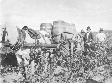
Photograph, Grape Picking in Great Western 1902
B/W photo of three men with a white horse pulling a cart with barrels of grapes just picked. Taken at Arrawatta Vineyard at Irvine's, Great western near Jonathon Gully and German Gully Roads. 1902win, wineries -
 Bendigo Historical Society Inc.
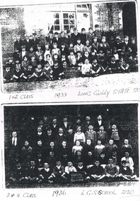
Photograph - LONG GULLY HISTORY GROUP COLLECTION:LONG GULLY STATE SCHOOL PHOTOS 1933 AND 1936
Photocopy of two photos on a page. The first is 1 & 2 Class 1933 Long Gully State School taken outside a brick building. Two boys in the front row are holding a black board with Long Gully School Grades I & II written on it. The Second photo the 3 & $ Class 1936. L. G. S School 2120. Two boys in the front row are holding a black board with Long Gully School Grades III & IV 1936 written on it. the photo is very dark.bendigo, history, long gully history group, the long gully history group - long gully state school photos 1933 and 1936 -
Bendigo Historical Society Inc.
Book - THE GOLDEN VALLEY, 1980
32 page soft cover booklet 'The Golden Valley - An account of the Wattle Gully Area.' An account of the rehabilitation of the Wattle Gully Mine, illustrated with colour photos. Booklet prepared to commemorate the reopening of the mine by Rupert Hamer, Premier of Victoria in 1980. On page 15 is a handwritten note in biro 'To Ray Wallace - I had great pleasure in researching, photographing & preparing all the information here - this was a limited edition publication for shareholders of Wattle Gully in 1980 Regards Felix Cappy' Author and publisher not givenUnknown -
 The Beechworth Burke Museum
Photograph, 1907-8
The photo from 1907-8 is a sepia print, depicting a small valley with building at base. There are flumes visible above areas of water, trees on hills and a few small cottages on the hillside. Cock's Pioneer Gold & Tin Sluicing Co NZ No 2 Site. The photo was taken of Matthews Gully looking west. Sluicing was undertaken in the area from 1900 to 1942 with some short breaks between these periods. The image depicts a location mined by Cocks Pioneer Gold and Tin Sluicing Company (as recorded on the annotation on the card mount) The Cocks Pioneer Gold and Tin Mines N.L was one of El Dorado's two largest open cut sluicing mines of the 20th Century. The other was named the Cocks El Dorado Gold Dredging Company. The Cocks Pioneer Mines operated from 1901 until 1941 and found a total of 117,378 ounces of Gold and 1,673 tones of tin concentrates over these years. The Cocks company was formed in 1898 and operated until 1941. Open cut sluicing involved the use of high-powered hoses which used the centrifugal sand pump system (known as hydraulic sluicing) which broke down the soil which was then processed for gold and other precious metals. From 1914 , four years after this image was captured, the company reformed to Cocks Pioneer Gold and Tin Mines NL (previously it was known as Cocks Pioneer Sluicing Co) and undertook large scale sluicing operations until 1929 and then 1934-1941. El Dorado is located on Reedy Creek and is surrounded by forested country to the north and east. It is 20 km east of Wangaratta in Victoria's regional north-east. John Cock was the son of a Cornish minor who arrived in El Dorado in 1858. Cock founded his gold and tin mining company which ran successfully for many years in the El Dorado region. It was an open cut sluicing company because of the abandonment of underground mining after this was deemed too dangerous. In 1935 Cock's El Dorado Company commissioned the floating dredge which is still visible in El Dorado today. The dredge was built by the Thompson engineering works, Castlemaine, and weighed over 2,000 tones and today has a place on the Victorian Registers of historic buildings. Interestingly, the name El Dorado does not derive from the gold in the region, but from the Barambogie pastoral run completed by William Baker in 1840-1841. Gold was discovered in El Dorado 1854 but the gold was too deep for individual prospectors to find, it required the use of heavy machinery.The search for gold is ingrained into the history of Victoria and therefore, images like this one which portray an open cut sluicing site can reveal important information for society and technology for the date when the photograph was taken. This image is of important historical significance for its ability to convey information about sluicing and the methods used to find gold in 1910. It also shows a location where sluicing was undertook which provides insight into the impact of sluicing on the environment at a time when it was done. This image is important for current research into the history of El Dorado, a small regional location near Wangaratta in Victoria's North East. Therefore, this image has the capacity to be beneficial for research into society and the motivations of those living and working in this region during this period and therefore, has social significance. The Beechworth Burke Museum has additional images relating to gold sluicing and El Dorado which can be analysed and studied alongside images like this one.Sepia coloured rectangle photograph printed on gloss photographic paper Reverse: 1997. 2613/ A02613/ No2 site/ Matthews Gully/ Cocks Pioneer G&T. ?? Co NZ/ No2 Site looking West/ 1907-8/ (7)sluicing, hydraulic sluicing, 1907, 1908, mining, cock's pioneer gold & tin sluicing co nz, nz, site no 2, matthews gully, west, valley, building, cottages, hillside, trees, water, gold and tin mine