Showing 786 items matching " murray river"
-
 Merbein District Historical Society
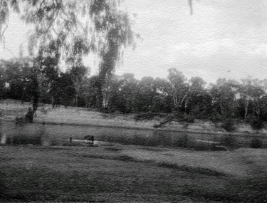
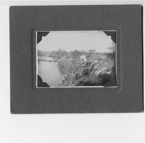
Photograph, Merbein River Scene, unknown
... Murray River... Merbein township Murray River Merbein River Scene Photograph ...merbein township, murray river -
 Merbein District Historical Society
Photograph, Cowanna Bend Early 1950's Start of washout, c.1953
... Murray River... Cowanna washout Murray River Cowanna Bend Early 1950's Start ...cowanna washout, murray river -
 Merbein District Historical Society
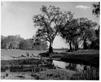
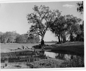
Photograph, Cowanna Bend cutoff towards Coomealla 1950, unknown
... Murray River... Murray River Cowanna Bend cutoff Coomealla Cowanna Bend cutoff ...murray river, cowanna bend cutoff, coomealla -
 Merbein District Historical Society
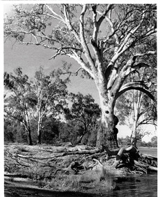
Photograph, Cowanna Bend cutoff towards Merbein, unknown
... Murray River... Murray River Cowanna Bend cutoff Coomealla Crosbies Cowanna Bend ...murray river, cowanna bend cutoff, coomealla crosbies -
 Merbein District Historical Society
Photograph, Boats moored at Hut below Mildara Winery, c.1950's
... Murray River Boats... Murray River Boats Merbein Boats moored at Hut below Mildara ...murray river boats, merbein -
 Merbein District Historical Society
Photograph, Merbein Cliffs and Merbein Pumping Station, c.1930
... Murray River... Murray River Merbein Cliffs and Merbein Pumping Station ...murray river -
 Merbein District Historical Society
Slide, Abbotsford Bridge, NSW side, unknown
... Murray River... Abbotsford Bridge Murray River Abbotsford Bridge, NSW side Slide ...abbotsford bridge, murray river -
Merbein District Historical Society
Slide, White cliffs at Merbein (3 slides), unknown
... Murray River - Merbein... Murray River - Merbein White cliffs at Merbein (3 slides) Slide ...murray river - merbein -
Merbein District Historical Society
Journal - Quarterly, Merbein Historian - Journal MDHS - No 13 (ex. The Newsletter) (2 copies) Sep. 2003, 2003
... 150th Anniversary of Murray River Shipping... Anniversary of Murray River Shipping Lady Augusta Charles Sturt ...150th anniversary of murray river shipping, lady augusta, charles sturt, abbotsford bridge 75th anniversary, witchetty tribe, harry traeger, jack lapthorne, f.c. kane, len keens, merbein west state school, mary jamieson, alexander "sandy" jamieson, bowring's staff -
 Merbein District Historical Society
Photograph, Abbotsford Bridge, 1937
... Murray River... Abbotsford Bridge Murray River Abbotsford Bridge Photograph ...abbotsford bridge, murray river -
 Merbein District Historical Society
Photograph, Abbotsford Bridge, 1927
... Murray River... Abbotsford Bridge Murray River Abbotsford Bridge Photograph ...abbotsford bridge, murray river -
 Merbein District Historical Society
Photograph, Abbotsford Bridge & Punt, 1927
... Murray River... Abbotsford Bridge Murray River Abbotsford Bridge & Punt Photograph ...abbotsford bridge, murray river -
Merbein District Historical Society
Journal - Quarterly, Merbein Historian - MDHS - No 29 (2 copies) Sept.2007, Sept.2007
... Murray River Flood 1956... Arthur Lever Murray River Flood 1956 Francis Nettleton Merbein ...anniversary 10th mdhs, leon wagner, life membership, wedding parade, wentworth junction steam rally, william blandowski, merbein houses, arthur lever, murray river flood 1956, francis nettleton -
Merbein District Historical Society
Photograph, River Road 1956 flood, 1956
... Murray River Flood 1956... Floods Murray River Flood 1956 River Road 1956 flood Photograph ...floods, murray river flood 1956 -
Merbein District Historical Society
Photograph, Johnston Block 1956 Flood - Ranfurly, 1956
... Murray River Flood 1956... Murray River Flood 1956 Johnston Block 1956 Flood - Ranfurly ...murray river flood 1956 -
Merbein District Historical Society
Photograph, Krake Children 1956 Flood Johnson Block Ranfurly, 1956
... Murray River Flood 1956... Murray River Flood 1956 Krake Children 1956 Flood Johnson Block ...murray river flood 1956 -
Merbein District Historical Society
Photograph, Flooded Vines 1956 Flood, 1956
... Murray River Flood 1956... Murray River Flood 1956 Flooded Vines 1956 Flood Photograph ...murray river flood 1956 -
Merbein District Historical Society
Booklet, Merbein Historian No 27, Mar.2007
... Murray River Flood Merbein... jubilee Bronwyn Zrna Houses Don Kimpton Martha Barraclough Murray ...bert curtis, world war 11, judy hyde, merbein memories 1930's, district jubilee, bronwyn zrna, houses, don kimpton, martha barraclough, murray river flood merbein, bernadette wells -
Merbein District Historical Society
Booklet, Merbein Historian No. 28 - 2 copies (replaced copy 2/3/2009), Jun.2007
... Murray River flood Merbein... Store Anzacs World War 11 Murray River flood Merbein Methodist ...leon wagner, missen-wellington wedding , wedding display, south merbein store, anzacs, world war 11, murray river flood merbein, methodist church merbein, litchfield family, beitzel home, joseph jamieson -
 Federation University Historical Collection
Book, Geological Gossip or Stray Chapters on Earth and Ocean, 1860, 1860
... murray river... australian interior eyre's expedition murray river darling river ...Brown hard covered book. Chapter 16 is on gold deposits and discusses the discovery of gold in California and Australia.Brown hard covered book geology, water, rivers, the atlantic, great deep, africa, australian interior, eyre's expedition, murray river, darling river, earthqaukes, leichardt, moreton bay, volcanos, darwin's theory, evolution, egyptian race, human remains in caverns and gravel, rocks, metamorphism, iron ores, coal, coal fields, gold deposits, california, water-glass, artificial stone, porous stones, cements -
 Port of Echuca
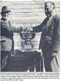
Award - Trophy Cup, William Randell Trophy
... Murray River... William Randell Trophy Murray River William Randell Trophy Echuca ...Large silver plated trophy cup punch bowl with embossed edge. Embossing depicts grape vineWilliam Randell Trophy Echuca 1974. Small engraving on base, hard to decipher but possibly has the word 'Paramount' on inscription. Paramount silver is possibly associated with silver firm "K.G. Luke" of Melbourne, Australia during 20th centuryport of echuca, punch bowl, silver plate, paddlesteamers, william randell trophy, murray river -
 Wodonga & District Historical Society Inc
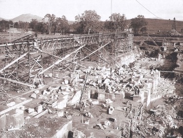
Album - Hume Reservoir Australia Album - Foundation work and dam construction, June 1924
... River Murray Waters Scheme...DEPARTMENT OF PUBLIC WORKS, N.S.W. RIVER MURRAY WATERS... OF PUBLIC WORKS, N.S.W. RIVER MURRAY WATERS SCHEME. HUME RESERVOIR ...This set of photos is from a leather bound album bearing the inscription "HUME RESERVOIR AUSTRALIA" plus 'The Rt. Hon. L. C. M. S. Amery, P. C., M .P.' all inscribed in gold. It was presented to The Rt. Hon. L. C. M. S. Amery, P. C., M. P, Secretary of State for Dominion Affairs on the occasion of his visit to the Hume Reservoir on 2nd November 1927. This album is of local and national significance as it documents the planning and development of the Hume Reservoir up to 1927. It was the largest water reservoir in the British Empire. The album records the pioneering engineering work that went into its construction.DEPARTMENT OF PUBLIC WORKS, N.S.W. RIVER MURRAY WATERS SCHEME. HUME RESERVOIR. 13. Foundation work and dam construction proceeding inside levee bank which may be seen at the right hand end of the work, New South Wales, June 1924.hume reservoir australia, river murray waters scheme, hume reservoir construction -
 Wodonga & District Historical Society Inc
Album - Hume Reservoir Australia Album - Gravity incline for transport of rocks
... River Murray Waters Scheme...DEPARTMENT OF PUBLIC WORKS, N.S.W. RIVER MURRAY WATERS... OF PUBLIC WORKS, N.S.W. RIVER MURRAY WATERS SCHEME. HUME RESERVOIR ...This set of photos is from a leather bound album bearing the inscription "HUME RESERVOIR AUSTRALIA" plus 'The Rt. Hon. L. C. M. S. Amery, P. C., M .P.' all inscribed in gold. It was presented to The Rt. Hon. L. C. M. S. Amery, P. C., M. P, Secretary of State for Dominion Affairs on the occasion of his visit to the Hume Reservoir on 2nd November 1927. This album is of local and national significance as it documents the planning and development of the Hume Reservoir up to 1927. It was the largest water reservoir in the British Empire. The album records the pioneering engineering work that went into its construction.DEPARTMENT OF PUBLIC WORKS, N.S.W. RIVER MURRAY WATERS SCHEME. HUME RESERVOIR. 16. Gravity incline for transport of "plums" from Quarry, New South Wales. "Plums" were larger rocks which could be re-used for other construction purposes.hume reservoir australia, river murray waters scheme, hume reservoir construction -
 Wodonga & District Historical Society Inc
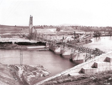
Album - Hume Reservoir Australia Album - General View of Works from New South Wales end, Looking Upstream, August 1927
... River Murray Waters Scheme...DEPARTMENT OF PUBLIC WORKS, N.S.W. RIVER MURRAY WATERS... OF PUBLIC WORKS, N.S.W. RIVER MURRAY WATERS SCHEME. HUME RESERVOIR ...This set of photos is from a leather bound album bearing the inscription "HUME RESERVOIR AUSTRALIA" plus 'The Rt. Hon. L. C. M. S. Amery, P. C., M .P.' all inscribed in gold. It was presented to The Rt. Hon. L. C. M. S. Amery, P. C., M. P, Secretary of State for Dominion Affairs on the occasion of his visit to the Hume Reservoir on 2nd November 1927. This album is of local and national significance as it documents the planning and development of the Hume Reservoir up to 1927. It was the largest water reservoir in the British Empire. The album records the pioneering engineering work that went into its construction.DEPARTMENT OF PUBLIC WORKS, N.S.W. RIVER MURRAY WATERS SCHEME. HUME RESERVOIR. 23. General view of works from the New South Wales end, looking downstream. The features are generally speaking the same as in the last view 22 (Record WHS 00716) in reverse.hume reservoir australia, river murray waters scheme, hume reservoir construction -
 Wodonga & District Historical Society Inc
Album - Hume Reservoir Australia Album - Introduction - Part 1, Department of Public Works, N.S.W, 1927
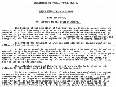
... River Murray Waters Scheme...RIVER MURRAY WATERS SCHEME, HUME RESERVOIR THE LARGEST... Murray Waters Scheme RIVER MURRAY WATERS SCHEME, HUME RESERVOIR ...This set of photos is from a leather bound album bearing the inscription "HUME RESERVOIR AUSTRALIA" plus 'The Rt. Hon. L. C. M. S. Amery, P. C., M .P.' all inscribed in gold. It was presented to The Rt. Hon. L. C. M. S. Amery, P. C., M. P, Secretary of State for Dominion Affairs on the occasion of his visit to the Hume Reservoir on 2nd November 1927. This album is of local and national significance as it documents the planning and development of the Hume Reservoir up to 1927. It was the largest water reservoir in the British Empire. The album records the pioneering engineering work that went into its construction.RIVER MURRAY WATERS SCHEME, HUME RESERVOIR THE LARGEST IN THE BRITISH EMPIRE. ' The history of the inception of the River Murray Waters Agreement under the terms of which the Hume Reservoir is being constructed, the purposes of the work, its correlation to the other works on the Murray and the methods of construction are all outlined in the attached article entitled “The River Murray Waters Scheme, the Nile of Australia”, by Mr H.H. Dare, M.E., M.Inst.C.E., Commissioner, Water Conservation and Irrigation, and the New South Wales Representative on the River Murray Commission. The article was published in 1925 and some alterations brought about by the efflux of time are necessary. As far as personnel is concerned, the death of Mr J.S. Dethridge, M.Inst.C.E., removed a very able engineer from the councils of the Commission. His place as Representative of Victoria has been taken by Mr R. Horsfield. It is also to be regretted that ill-health has caused the retirement of Mr E.M. de Burgh, M.Inst.C.E., the eminent Chief Engineer for New South Wales, who, with Mr Dethridge, was largely responsible for the Agreement cemented by the River Murray Waters Acts and, inter alia, for the design of the Hume Dam. The following summary of the progress of work on the Locks might be substituted for the latter part of Mr Dare’s paragraph. Up to the present time six locks and weirs have been completed, the highest in the series being at Torrumberry and the lowest at Blanchetown. Locks No.26 at Torrumberry and No.11 at Mildura were built by Victoria and are in use. A lock and weir (No.10) is in progress at Wentworth, and the necessary camp arrangements, purchase of plant, etc., have been undertaken in connection with lock and weir No.15 at Euston, both under the direction of New South Wales. Lock No.9, which forms part of the Lake Victoria Scheme, Lock No.5 at Renmark and Lock No.3 in South Australia hume reservoir australia, river murray waters scheme -
 Wodonga & District Historical Society Inc
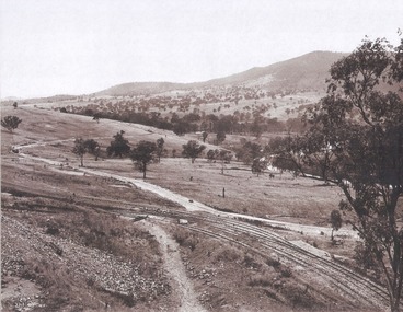
Album - Hume Reservoir Australia Album - Valley of the Murray to be crossed by the Bethanga Bridge 1927
... River Murray Waters Scheme...DEPARTMENT OF PUBLIC WORKS, N.S.W. RIVER MURRAY WATERS... OF PUBLIC WORKS, N.S.W. RIVER MURRAY WATERS SCHEME. HUME RESERVOIR ...This set of photos is from a leather bound album bearing the inscription "HUME RESERVOIR AUSTRALIA" plus 'The Rt. Hon. L. C. M. S. Amery, P. C., M .P.' all inscribed in gold. It was presented to The Rt. Hon. L. C. M. S. Amery, P. C., M. P, Secretary of State for Dominion Affairs on the occasion of his visit to the Hume Reservoir on 2nd November 1927. This album is of local and national significance as it documents the planning and development of the Hume Reservoir up to 1927. It was the largest water reservoir in the British Empire. The album records the pioneering engineering work that went into its construction.DEPARTMENT OF PUBLIC WORKS, N.S.W. RIVER MURRAY WATERS SCHEME. HUME RESERVOIR. 36. Valley of the Murray to be crossed by the Bethanga Bridge described in the next photograph. (WHS 00731) This view shows the marshalling sidings for trucks below the Quarry, New South Wales, and the branch line to the site of the bridge.hume reservoir australia, river murray waters scheme, hume reservoir construction -
Lakes Entrance Historical Society
Book, North East Regional Tourist Authority, North East Victoria, 1980
... A brief record of the region from the Murray River... record of the region from the Murray River in the north ...A brief record of the region from the Murray River in the north to the Dargo High Plains in the south, from Yarrawonga and Wangaratta in the west to the Indi River in the east. Illustrated with coloured photographs.tourism, mines and mining, settlers, water supply -
 Wodonga & District Historical Society Inc
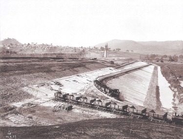
Album - Hume Reservoir Australia Album - Concrete Slabs on embankment, August 1927
... River Murray Waters Scheme...DEPARTMENT OF PUBLIC WORKS, N.S.W. RIVER MURRAY WATERS... OF PUBLIC WORKS, N.S.W. RIVER MURRAY WATERS SCHEME. HUME RESERVOIR ...This set of photos is from a leather bound album bearing the inscription "HUME RESERVOIR AUSTRALIA" plus 'The Rt. Hon. L. C. M. S. Amery, P. C., M .P.' all inscribed in gold. It was presented to The Rt. Hon. L. C. M. S. Amery, P. C., M. P, Secretary of State for Dominion Affairs on the occasion of his visit to the Hume Reservoir on 2nd November 1927. This album is of local and national significance as it documents the planning and development of the Hume Reservoir up to 1927. It was the largest water reservoir in the British Empire. The album records the pioneering engineering work that went into its construction.DEPARTMENT OF PUBLIC WORKS, N.S.W. RIVER MURRAY WATERS SCHEME. HUME RESERVOIR. 33. Concrete Slabs on Embankment. The upstream face of the embankment is being protected from the effects of wave action by concrete slabs 12 inches thick laid in squares in situ. The thrust at the toe of the bank is taken care of by a body of granite blocks and spalls. Victoria. August 1927.hume reservoir australia, river murray waters scheme, hume reservoir construction -
 Port of Echuca
Photograph, 04.03.1983
... of the Murray river....., with a line of spectators along the higher banks of the Murray river ...Colour photograph of the P. S. Adelaide in the river, with half of the aft side and the back of the boat clearly visible. The bank behind is lined with spectators. Five men are on the back of the boat and to the right another person is visible on a platform that has a rope which appears to be attached to the front of the P. S. Adelaide. Part of the photo sequence of the event no.:P000041; P000045; P000046; P000047; P000048 of the P. S. Adelaide re-floating.The re-floating of the P. S. Adelaide was a Significant community social event evident by the number of spectators in the photograph. The community had invested a great deal of time and money into re-floating the paddlesteamer. The newspaper covered the event in detail with a number of action shots as the boat made its rear entry from the temporary slipway onto the river. Part of a photo sequence no.P000041; P000045; P000046; P000047; P000048 of P. S. Adelaide re-floating.Colour photograph of the back half of starboard and the rear of the P. S. Adelaide, possibly being towed, after its re-floating., with a line of spectators along the higher banks of the Murray river.p. s. adelaide, echuca,victoria, re-floating of the p. s. adelaide. riverine herald newspapers, -
 Wodonga & District Historical Society Inc
Album - Hume Reservoir Australia Album - View of site on 28th November 1919
... River Murray Waters Scheme...DEPARTMENT OF PUBLIC WORKS, N.S.W. RIVER MURRAY WATERS... DEPARTMENT OF PUBLIC WORKS, N.S.W. RIVER MURRAY WATERS SCHEME. HUME ...This set of photos is from a leather bound album bearing the inscription "HUME RESERVOIR AUSTRALIA" plus 'The Rt. Hon. L. C. M. S. Amery, P. C., M .P.' all inscribed in gold. It was presented to The Rt. Hon. L. C. M. S. Amery, P. C., M. P, Secretary of State for Dominion Affairs on the occasion of his visit to the Hume Reservoir on 2nd November 1927. This album is of local and national significance as it documents the planning and development of the Hume Reservoir up to 1927. It was the largest water reservoir in the British Empire. The album records the pioneering engineering work that went into its construction.DEPARTMENT OF PUBLIC WORKS, N.S.W. RIVER MURRAY WATERS SCHEME. HUME RESERVOIR. 3. View of site on 28th November 1919 when the first sod was turned by the Governor General Sir Ronald Munro Ferguson, now Lord Hovar. The view is taken from the New South Wales end of the dam looking across the Murray to Victoria. The Murray flows from left to right.hume reservoir australia, river murray waters scheme, hume weir diagrams, hume plan details