Showing 1887 items
matching north rd
-
 Eltham District Historical Society Inc
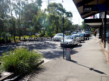
Photograph - Digital Photograph, Jim Connor, Main Road, Eltham from Arthur Street looking north, 18 April 2018
jim connor collection, anz (eltham), eltham shopping centre, main road -
 Eltham District Historical Society Inc
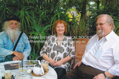
Photograph, Fay Bridge, Book launch of Laughing Waters Road by Jane Woollard at Montsalvat, Eltham, 30 January 2016
Laughing Waters Road , the book was launched at Montsalvat in Eltham. On Saturday, January 30, 2016, Nillumbik Council launched this book. The weather was cool; just as well, considering over 500 people attended this very pleasant event where food and drink were plentiful. The Australian Government and Nillumbik Shire Council funded the book and it was designed by Wayne Rankin of North Warrandyte. The dedication page is to our very own Ranger Campbell Beardsell OAM of Parks Vic who taught Jane to be “passionate about the environment of this special place” (p260). FOWSP members Val Polley, Linda Rogan and Ken Crook contributed to the content and photos. David Wandin, Wurundjeri Elder, gave a Welcome to Country and officially launched the book after the Mayor of Nillumbik, Cr Hattam, made introductions. Jane Woollard followed with a brief outline of how she came to write the book (her very first) and read out loud the last paragraph which focuses on reconciliation and shared culture. Jane declared in her preface that the book “has been formed by attending to the connection between rivulets of memories, creeks of hearsay, rivers of tales, the meanders of local legend and the deep, still pools of the archive.” Very poetic! - Lynda Gilbert Newsletter; Friends of Warrandyte State Park March 2016, Volume 34 Number 2 Laughing Waters Road , the book was launched at Montsalvat in Eltham ON SATURDAY 30 JANUARY Nillumbik Council launched this book. The weather was cool; just as well, considering over 500 people attended this very pleasant event where food and drink were plentiful. The Australian Government and Nillumbik Shire Council funded the book and it was designed by Wayne Rankin of North Warrandyte. The dedication page is to our very own Ranger Campbell Beardsell OAM of Parks Vic who taught Jane to be “passionate about the environment of this special place” (p260). FOWSP members Val Polley, Linda Rogan and Ken Crook contributed to the content and photos. David Wandin, Wurundjeri Elder, gave a Welcome to Country and officially launched the book after the Mayor of Nillumbik, Cr Hattam, made introductions. Jane Woollard followed with a brief outline of how she came to write the book (her very first) and read out loud the last paragraph which focuses on reconciliation and shared culture. Jane declared in her preface that the book “has been formed by attending to the connection between rivulets of memories, creeks of hearsay, rivers of tales, the meanders of local legend and the deep, still pools of the archive.” Very poetic! - Lynda Gilbert Newsletter; Friends of Warrandyte State Park March 2016, Volume 34 Number 2 https://fowsp.org.au/docs/News_2016/34_02_March.pdffay bridge collection, 2016-01-30, book launch, bronnie hattam, jane woollard, laughing waters road, montsalvat, sigmund jorgensen, harry gilham, maurice hurry -
 Eltham District Historical Society Inc
Photograph, Fay Bridge, Eastern boundary of former Warrandyte Aboriginal Reserve, North Warrandyte, 7 November 2016
Two bronze commemorative plaques on rocks, unveiled by Wurundjeri Tribe Council Elders, mark two eastern boundaries of the former Warrandyte Aboriginal Reserve on the north and south sides of the Yarra. This project was initiated by Nillumbik Reconciliation Group in close association with Reconciliation Manningham and the Wurundjeri Tribe Council, as a means of commemorating the last great corroboree of the Kulin Nation which was held at Pound Bend in March 1852. This plaque is on the Nillumbuk side of the Yarra, accessed via The Boulevard, North Warrandyte. The plaque is set on a rock approximately 50 metres before the turning circle at the end of The Boulevard. Plaque : Warrandyte Aboriginal Reserve This commemorative rock marks an eastern boundary of the former Warrandyte Aboriginal Reserve established in 1852. Centred on Pound Bend, it covered 1,908 acres on both sides of the Yarra River (Birrarung). That same year saw the last great gathering of the Kulin nation here in Wurundjeri country which was celebrated over two weeks with traditional performance and games. For a few years longer the reserve intermittently served as a ration station.With gold having been discovered at Warrandyte, the Wurundjeri were moved on again but ultimately secured a permanent home at Coranderrk, Healesville. A second commemorative plaque and rock is located on the opposite bank of the Yarra and its confluence with Stony Creek. Melway ref : 23 C 9 Unveiled by Wurundjeri Elder, Uncle Bill Nicholson on 23rd March 2013 Funded by the Robert Bridgford Indigenous Trust (Nillumbik Community Fund) with assistance from Manningham City Council Small Grants Program Ref: Monument Autralia https://monumentaustralia.org.au/themes/culture/indigenous/display/99680-warrandyte-aboriginal-reserve-fay bridge collection, 2016-11-07, aboriginal reserve, north warrandyte, plaques, warrandyte aboriginal reserve -
 Eltham District Historical Society Inc
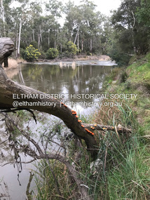
Photograph, Fay Bridge, Yarra River near the eastern boundary of former Warrandyte Aboriginal Reserve, North Warrandyte, 11 August 2023
Accessed via The Boulevard, North Warrandytefay bridge collection, aboriginal reserve, north warrandyte, warrandyte aboriginal reserve, 2023-08-11 -
 Eltham District Historical Society Inc
Photograph, Fay Bridge, EDHS Heritage Excursion, Edendale Farm, 5 May 2018
May Excursion – Edendale Environs Edendale Community Environment Farm in Gastons Road, Eltham now operates as Nillumbik Council’s environmental centre. The historic homestead has undergone a significant restoration and there is on-going development of the site consistent with its community education purpose. The house and the gateway sculpture “The Fences Act” are covered by a Heritage Overlay in the Nillumbik Planning Scheme. Our May excursion will comprise a walk through the farm property and will radiate to other nearby places of historic interest. These will include the site of the Eltham North Adventure Playground to discuss its history and destruction by fire (see page 1 article). Also nearby is Colemans Corner where the early road system has undergone some unusual changes. If time permits we may visit some other nearby places of interest. - EDHS Newsletter No. 239 April 2018fay bridge collection, 2018-05-05, edendale community farm, edendale farm, eltham district historical society, heritage excursion, activities -
 Eltham District Historical Society Inc
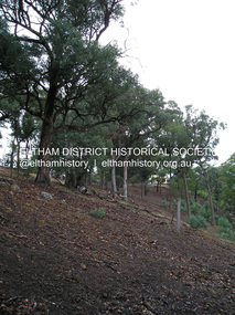
Photograph, Fay Bridge, Longridge, Alexander Road, Warrandyte, 4 May 2019
Situated on the Warrandyte side of the Yarra River opposite Glynn's Dairy Farm, North Warrandyte, the property is in ruins and remains fenced off as of 2023fay bridge collection, glynns, longridge, ruins, warrandyte, 2019-05-04, alexander road -
 Eltham District Historical Society Inc
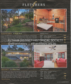
Document - Property Binder, 1514 Main Road, Research
Newspaper advertisement: The Weekly Review, 11 July 2012, Fletchers estate agent sale of 1514 Main Road Research. Newspaper advertisement: The Weekly Review, 11 July 2012, Fletchers estate agent sale of 70 Banks Road Eltham North. Newspaper advertisement: The Weekly Review, 11 July 2012, Fletchers estate agent sale of 1/45 Beard Street Eltham.main road, property, research (vic.), fletchers real estate, eltham (vic), eltham north (vic) -
 Eltham District Historical Society Inc
Photograph, Peter Pidgeon, Main Road at Pitt Street, Eltham, 2 Aug. 2022
Main Road looking north from Pitt Street. Comparison photo: SEPP_0626 - Main Road north of Pitt Street, c.1910 On the far left is Mrs Mary Ann Morris' house and shop and Hill's House. William Morris was the publican for the Evelyn Hotel which was on the opposite corner of Pitt Street and Main Road. Also believed to be the Scarce house at some stage, Mrs Emily Scarce was President of the Australian Women's National League. On the right is Webster's then the Commercial Bank of Australia branch, the Methodist Church just behind it on John Street. To the immediate right out of visibility is Watson's Eltham Hotel. Part of a presentation by Peter Pidgeon to the Society, 13 August 2022 showcasing a series of photographs taken by John Henry Clark over the period 1895 to 1930. John Henry Clark was the youngest of three boys born to William Henry Clark (1823-1877) and Maria White (1843-1914). He and his brothers, William Charles Clark (1872-1945), Clement Kent Clark (1874-1912) operated a photography business (Clark Bros.) from 25 Thomas Street, Windsor near Prahran during the period c.1894 to 1914. Following death of Clement in September 1912 and their mother in 1914, the Clark Bros business appears to have dissolved, the premises demolished, and a new house was under construction in 1915. John set up business independently in 1914 operating out of 29 Moor Street, Fitzroy where he is registered in the 1914 and 1915 Electoral Rolls. By 1916 John had relocated to Eltham where he continued his practice as a photographer and took many of the early images around the district of Little Eltham. Around 1930 John changed professions and opened a small cobbler's shop in 1931 near the pond opposite Dalton Street adjacent to the Jarrold family cottage. He never married and continued his profession as a bootmaker from this little shop, maintaining a close relationship with Mrs Jarrold for the rest of their lives. His bootmaker shop remains today beside the Whitecloud cottage and is one of only three remaining shops in the area from the early 20th century.Comparative photo taken 2022 with one taken from same location over 100 years earlier by noted local photographer J.H. ClarkBorn Digitaleltham, j.h. clark photo (2022), main road, pitt street -
 Eltham District Historical Society Inc
Document - Folder, Warrandyte Bushfire Relief, 1962
Following the January 1962 bushfires in Warrandyte, affected land holders and residents made application for financial assistance. These records are a small part of more than 1,300 applications made at the time. Contents include: Approximately 200 applications for assistance which include details of property, residence (holiday, farm holding, main residence), residents and property loss Approximately 500 Council responses for each application Miscellaneous correspondencePovides a clear description of property ownership, type, size, holdings and people at the timeapplication form, assessments, bushfire relief, eltham shire council, north warrandyte, scan - tbd, victorian bushfires - 1962, warrandyte -
 Eltham District Historical Society Inc
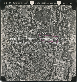
Photograph - Aerial Photograph, Montmorency to Eltham North, 11 Jan. 1984
Area highlighted in purple is the future Nerreman Gateway Estate spanning from Ryans Road to Karingal Driveshire of eltham archives, aerial photo, eltham north, montmorency, nerreman gateway, nerreman park estate, ryans road, karingal drive -
 Eltham District Historical Society Inc
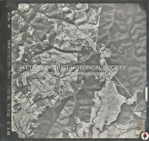
Photograph - Aerial Photograph, Smiths Gully, Christmas Hills, St Andrews, Kinglake National Park, 6 Mar. 1986
Small scale Red arrow indicates Northshire of eltham archives, aerial photo, christmas hills, kinglake national park, smiths gully, st andrews -
 Eltham District Historical Society Inc
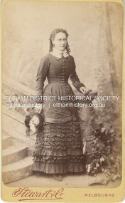
Photograph, Stewart & Co, Possibly Margaret Shillinglaw, c.1882
Margaret Shillinglaw was William and Jean Shillinglaw's ninth child. She was born at Northcote March 3, 1856 and died at North Fitzroy September 7, 1933. She never married. Stewart & Co operated from 217 Bourke St., East from 1871 to 1876 and from 217-219 from 1877 to 1889. Other locations included 42, 284 and 286. Overall, they operated in Melbourne from 1871 through at least 1910 though Carte-de-Visite photos were superseded by 1890. According to Lenore Frost's book, Dating Family Photos 1850-1920, the swathes of contrasting fabric across her abdomen is a peculiarity of 1882. CARTE-DE-VISITE (cdv) 1857-1890 Cartes-de-visite (cdv's) are the most common form of photograph from the nineteenth century, generally measuring two and a half inches by four and an eighth inches (6.3 x 10.5 cm) when mounted, sepia toned, mounted on a card which was generally printed with the photographer's name and address on the back or beneath the portrait. - Frost, Lenore; Dating Family Photos 1850-1920; Valiant Press Pty. Ltd., Berwick, Victoria 1991marg ball collection, shillinglaw family photo album 1, 1871-1890, 1882, margaret shillinglaw (1856-1933), stewart & co photographers melbourne, unknown -
 Eltham District Historical Society Inc
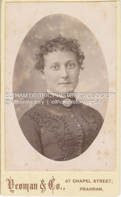
Photograph, Yeoman and Co, Possibly Margaret Shillinglaw, c.1887
Margaret Shillinglaw was William and Jean Shillinglaw's ninth child. She was born at Northcote March 3, 1856 and died at North Fitzroy September 7, 1933. She never married. Photographers Yeoman & Co. operated from 47 Chapel St., Prahran from 1883 to c.1891. CARTE-DE-VISITE (cdv) 1857-1890 Cartes-de-visite (cdv's) are the most common form of photograph from the nineteenth century, generally measuring two and a half inches by four and an eighth inches (6.3 x 10.5 cm) when mounted, sepia toned, mounted on a card which was generally printed with the photographer's name and address on the back or beneath the portrait. - Frost, Lenore; Dating Family Photos 1850-1920; Valiant Press Pty. Ltd., Berwick, Victoria 1991marg ball collection, shillinglaw family photo album 1, 1883-1891, 1887, margaret shillinglaw (1856-1933), unknown, yeoman & co photographer 47 chapel st prahran -
 Eltham District Historical Society Inc
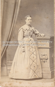
Photograph, Charles Nettleton, Believed to be Sarah Shillinglaw, c.1868
Sarah Shillinglaw was born at River Plenty on November 9, 1854. She married Charles Aldous on June 9, 1880 and died in Prahran, Victoria on August 3, 1925. Photographer Charles Nettleton operated from 1 Madeline St, North Melbourne (later known as Carlton) from 1867-1874.. This photo shows the address as North Melbourne. Sands McDogall Directory listing was revised to Carlton in 1869. This would date photo as 1867-1868 though could be later if printed on on paper stock. CARTE-DE-VISITE (cdv) 1857-1890 Cartes-de-visite (cdv's) are the most common form of photograph from the nineteenth century, generally measuring two and a half inches by four and an eighth inches (6.3 x 10.5 cm) when mounted, sepia toned, mounted on a card which was generally printed with the photographer's name and address on the back or beneath the portrait. - Frost, Lenore; Dating Family Photos 1850-1920; Valiant Press Pty. Ltd., Berwick, Victoria 1991marg ball collection, shillinglaw family photo album 2, 1867-1874, 1868, c. nettleton photographer 1 madeline st north melbourne, sarah aldous (nee shillinglaw 1854-1925), unknown -
 Eltham District Historical Society Inc
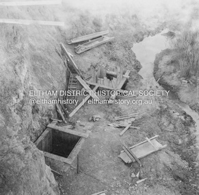
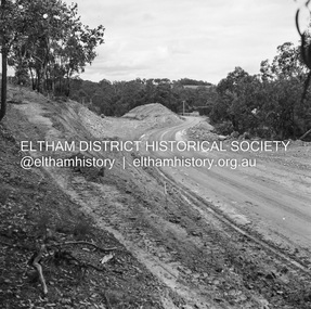
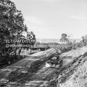
Album - Photograph, J.A. McDonald, Dixons Creek Road, Oct. 1955
October 1955 Ramping north sideRecord of various Shire of Eltham infrastructure works undertaken during the period of 1952-1962 involving bridge and road reconstruction projects, sometimes with Eltham Shire Council Project Reference numbers quoted. It was during this period that a number of significant improvements were made to roads and new bridges constructed within the shire that remain in place as of present day (2022). In many situations, the photos provide a tangible visible record of infrastructure that existed throughout the early days of the Shire. The album was put together by or under the direction of the Shire Engineer, J.A. McDonald.infrastructure, road construction, shire of eltham, 1955-10, bailey bridge, bridge construction, dixons creek bridge, dixon's creek road -
 Eltham District Historical Society Inc
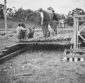
Album - Photograph, J.A. McDonald, Dixons Creek Road, June 1957
Dixons Creek Road P. Morris – Contractor Dixons Creek (North) abutment 1957 Advertising (1957, January 19). The Argus (Melbourne, Vic. : 1848 - 1957), p. 33 (Col. 9). Retrieved August 24, 2022, from http://nla.gov.au/nla.news-article71777065 SHIRE OF ELTHAM. Loan No. 27.-Notice of Intention to Borrow Sum of £ 15,000 for Permanent Works and Undertakings. - Notice is hereby given, that the Council of the Shire of Eltham proposes to borrow the sum of £15,000 on the credit of the municipal revenues of the president, councillors, and ratepayers for the said shire, such sum to be raised by the Issue of debentures in accordance with the provisions of the Local Government Acts. 1. Maximum rate of interest that may be paid is £5/10/ per cent, per annum. 2. The purposes for which the loan is to be applied are: Construction of Sanitary Conveniences at Shire Office, Council's contribution towards costs of Dixons Creek Bridge, Construction of Mt. Pleasant rd., Construction of Cherry Tree rd. 3. The period of the loan shall be 10 years. 4. Moneys borrowed will be repayable by providing out of the Municipal Fund twenty half-yearly instalments of approximately £985/1/6 each, including principal and interest on the first day of October and the first day of April during the currency of the loan. The first Instalment shall be payable on the first day of October 1957. 5. Such moneys shall be repayable at the Commercial Bank of Australia Limited, Melbourne, or at the Council's bankers for the time being in Melbourne. The plans and specifications and the estimates of the costs of the proposed works and a statement showing the proposed expenditure of the moneys to be borrowed are open for inspection at the Shire Office, Eltham. R. J. HAM. Shire Secretary.Record of various Shire of Eltham infrastructure works undertaken during the period of 1952-1962 involving bridge and road reconstruction projects, sometimes with Eltham Shire Council Project Reference numbers quoted. It was during this period that a number of significant improvements were made to roads and new bridges constructed within the shire that remain in place as of present day (2022). In many situations, the photos provide a tangible visible record of infrastructure that existed throughout the early days of the Shire. The album was put together by or under the direction of the Shire Engineer, J.A. McDonald.infrastructure, road construction, shire of eltham, bridge construction, dixons creek bridge, dixon's creek road, 1957-06 -
 Eltham District Historical Society Inc
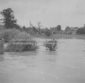
Album - Photograph, J.A. McDonald, Eltham-Greensborough Road, 18 Oct. 1956
Bridge Street Bridge Flooding on Hill’s property 18th October 1956 This view is looking west north west from the Bridge Street Bridge across the present day Eltham Skatepark. The shed visibile in the distance is directly opposite Brisbane Street where it used to run into Susan Street but now turns the corner. To the right of the shes is the site for present-dayHarris Plumbing which was formerly occupied by Sibbel Builders; to the left the site now occupied by Bunnings. At the skyline to the right of centreeline is a gap in the trees where the railway line runs. The Silver Street bridge over the railway is visible. Beware!.. our rivers are rising (1956, October 19). The Argus (Melbourne, Vic. : 1848 - 1957), p. 1. Retrieved August 24, 2022, from http://nla.gov.au/nla.news-article84392304Record of various Shire of Eltham infrastructure works undertaken during the period of 1952-1962 involving bridge and road reconstruction projects, sometimes with Eltham Shire Council Project Reference numbers quoted. It was during this period that a number of significant improvements were made to roads and new bridges constructed within the shire that remain in place as of present day (2022). In many situations, the photos provide a tangible visible record of infrastructure that existed throughout the early days of the Shire. The album was put together by or under the direction of the Shire Engineer, J.A. McDonald.infrastructure, road construction, shire of eltham, bridge construction, bridge street bridge, eltham, eltham-greensborough road, 1956-10-18, diamond creek (creek), floods, floodwater, hill property, silver street bridge -
 Eltham District Historical Society Inc
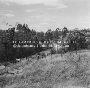
Album - Photograph, J.A. McDonald, Heidelberg-Kinglake Road, c. 1956
Hurstbridge-Kinglake Road at Cottlesbridge from Pills House to north c. 1956Record of various Shire of Eltham infrastructure works undertaken during the period of 1952-1962 involving bridge and road reconstruction projects, sometimes with Eltham Shire Council Project Reference numbers quoted. It was during this period that a number of significant improvements were made to roads and new bridges constructed within the shire that remain in place as of present day (2022). In many situations, the photos provide a tangible visible record of infrastructure that existed throughout the early days of the Shire. The album was put together by or under the direction of the Shire Engineer, J.A. McDonald.infrastructure, shire of eltham, 1956, bridge construction, heidelberg-kinglake road, road construction, cottlesbridge -
 Eltham District Historical Society Inc
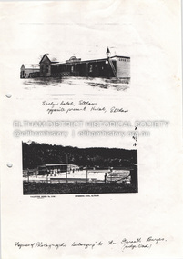
Document - Property Binder, 825 Main Road, Eltham
Photocopy photographs Evelyn Hotel Eltham and Eltham Swimming Pool, images owned by Garreth Burges. Elevations west, north, south, east, of proposed development by Germano Architects. Floor plans of proposed development by Germano Architects. Newspaper article: Council to reject apartments plan, Diamond Valley News, 20 May 1998, Nillumbik Council meeting, protestors against 25 unit development from Eltham Gateway Action Group. Newspaper public notice: Diamond Valley Leader 1 March 2006, Notice of Application for a Planning Permit, by Germano Architects. Newspaper article: Building at long last, Diamond Valley Leader, 3 September 2008, Nillumbik Council approved development plans.main road, eltham, property, businesses, evelyn hotel eltham, eltham swimming pool, eltham gateway action group, germano architects -
 Eltham District Historical Society Inc
Negative - Photograph, J.A. McDonald, Heidelberg-Kinglake Road, Sep. 1959
Job 56M430 Contractor Hone Same deviation looking south from north end towards HurstbridgeRecord of various Shire of Eltham infrastructure works undertaken during the period of 1952-1962 involving bridge and road reconstruction projects, sometimes with Eltham Shire Council Project Reference numbers quoted. It was during this period that a number of significant improvements were made to roads and new bridges constructed within the shire that remain in place as of present day (2022). In many situations, the photos provide a tangible visible record of infrastructure that existed throughout the early days of the Shire. The album was put together by or under the direction of the Shire Engineer, J.A. McDonald.infrastructure, shire of eltham, bridge construction, 1959-09, heidelberg-kinglake road, road construction -
 Eltham District Historical Society Inc
Negative - Photograph, J.A. McDonald, Heidelberg-Kinglake Road, 3 Nov. 1959
Job 56M431 Contractors Wolf and Wood Yow Yow Creek Bridge Curve improvement north of bridge site 3 November 1959Record of various Shire of Eltham infrastructure works undertaken during the period of 1952-1962 involving bridge and road reconstruction projects, sometimes with Eltham Shire Council Project Reference numbers quoted. It was during this period that a number of significant improvements were made to roads and new bridges constructed within the shire that remain in place as of present day (2022). In many situations, the photos provide a tangible visible record of infrastructure that existed throughout the early days of the Shire. The album was put together by or under the direction of the Shire Engineer, J.A. McDonald.infrastructure, shire of eltham, bridge construction, heidelberg-kinglake road, road construction, yow yow creek, 1959-11-03 -
 Eltham District Historical Society Inc
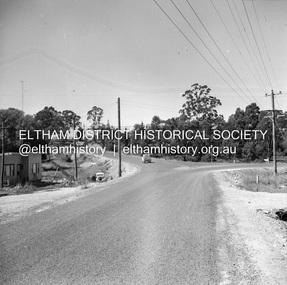
Negative - Photograph, J.A. McDonald, Heidelberg-Kinglake Road, Mar. 1960
Completed junction Looking north March 1960 Job 56M411Record of various Shire of Eltham infrastructure works undertaken during the period of 1952-1962 involving bridge and road reconstruction projects, sometimes with Eltham Shire Council Project Reference numbers quoted. It was during this period that a number of significant improvements were made to roads and new bridges constructed within the shire that remain in place as of present day (2022). In many situations, the photos provide a tangible visible record of infrastructure that existed throughout the early days of the Shire. The album was put together by or under the direction of the Shire Engineer, J.A. McDonald.infrastructure, 1960-03, bridge construction, cherry tree road, heidelberg-kinglake road, road construction, shire of eltham -
 Eltham District Historical Society Inc
Negative - Photograph, J.A. McDonald, Heidelberg-Kinglake Road, Mar. 1960
Job 56M431 Curve improvement north of Yow Yow Creek March 1960 Contractor F.C. WoodRecord of various Shire of Eltham infrastructure works undertaken during the period of 1952-1962 involving bridge and road reconstruction projects, sometimes with Eltham Shire Council Project Reference numbers quoted. It was during this period that a number of significant improvements were made to roads and new bridges constructed within the shire that remain in place as of present day (2022). In many situations, the photos provide a tangible visible record of infrastructure that existed throughout the early days of the Shire. The album was put together by or under the direction of the Shire Engineer, J.A. McDonald.infrastructure, 1960-03, bridge construction, cherry tree road, heidelberg-kinglake road, road construction, shire of eltham -
 Eltham District Historical Society Inc
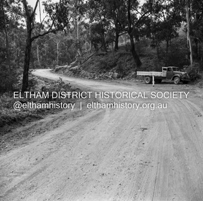
Negative - Photograph, J.A. McDonald, Heidelberg-Kinglake Road, Sep. 1960
... Eltham District Historical Society Inc 728 Main Rd Eltham ...Looking north from south boundary of St Andrews Township (Cr. Brinkkotter in car) Noted on album page as September 1960 but photo dated October on reverseRecord of various Shire of Eltham infrastructure works undertaken during the period of 1952-1962 involving bridge and road reconstruction projects, sometimes with Eltham Shire Council Project Reference numbers quoted. It was during this period that a number of significant improvements were made to roads and new bridges constructed within the shire that remain in place as of present day (2022). In many situations, the photos provide a tangible visible record of infrastructure that existed throughout the early days of the Shire. The album was put together by or under the direction of the Shire Engineer, J.A. McDonald.infrastructure, shire of eltham, bridge construction, road construction, cr. a. brinkkotter, heidelberg-kinglake road, st andrews, 1960-09 -
 Eltham District Historical Society Inc
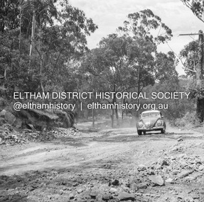
Negative - Photograph, J.A. McDonald, Heidelberg-Kinglake Road, Sep. 1959
Job 56M430 Contractor Hone Deviation opposite looking north from Hurstbridge endRecord of various Shire of Eltham infrastructure works undertaken during the period of 1952-1962 involving bridge and road reconstruction projects, sometimes with Eltham Shire Council Project Reference numbers quoted. It was during this period that a number of significant improvements were made to roads and new bridges constructed within the shire that remain in place as of present day (2022). In many situations, the photos provide a tangible visible record of infrastructure that existed throughout the early days of the Shire. The album was put together by or under the direction of the Shire Engineer, J.A. McDonald.infrastructure, shire of eltham, road construction, 1959-09, heidelberg-kinglake road -
 Eltham District Historical Society Inc
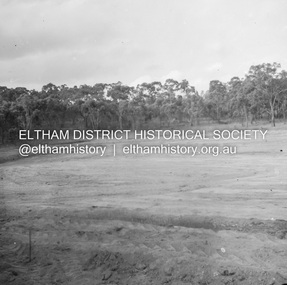
Negative - Photograph, J.A. McDonald, Reconstruction works, Research Oval, Jan. 1961
... Eltham District Historical Society Inc 728 Main Rd Eltham ...Looking north Early January 1961Record of various Shire of Eltham infrastructure works undertaken during the period of 1952-1962 involving bridge and road reconstruction projects, sometimes with Eltham Shire Council Project Reference numbers quoted. It was during this period that a number of significant improvements were made to roads and new bridges constructed within the shire that remain in place as of present day (2022). In many situations, the photos provide a tangible visible record of infrastructure that existed throughout the early days of the Shire. The album was put together by or under the direction of the Shire Engineer, J.A. McDonald.shire of eltham, 1961-01, infrastructure, reconstruction works, research (vic.), research oval -
 Eltham District Historical Society Inc
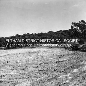
Negative - Photograph, J.A. McDonald, Reconstruction works, Research Oval, Jan. 1961
... Eltham District Historical Society Inc 728 Main Rd Eltham ...Looking north at end of reconstruction Late January 1961Record of various Shire of Eltham infrastructure works undertaken during the period of 1952-1962 involving bridge and road reconstruction projects, sometimes with Eltham Shire Council Project Reference numbers quoted. It was during this period that a number of significant improvements were made to roads and new bridges constructed within the shire that remain in place as of present day (2022). In many situations, the photos provide a tangible visible record of infrastructure that existed throughout the early days of the Shire. The album was put together by or under the direction of the Shire Engineer, J.A. McDonald.shire of eltham, 1961-01, infrastructure, reconstruction works, research (vic.), research oval -
 Eltham District Historical Society Inc
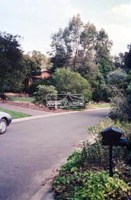
Slide - Photograph, Unidentified residential street, possibly Eltham North, c.Oct. 1989
35mm colour positive transparency Mount - Black and Whiteinfrastructure, streets, roads, eltham north, houses, residential, streetscape, unidentified -
 Eltham District Historical Society Inc
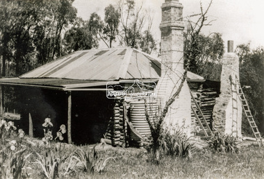
Photograph - Black and White Print, Old settler's cottage, Floods Lane, North Warrandyte, c.1935
... Road off Kangaroo Ground-Warrandyte Rd near boundary of North... Road off Kangaroo Ground-Warrandyte Rd near boundary of North ...An early settler's cottage of 1920s vintage near Floods Rd taken in the 1930s. Was originally Floods Lane and became Floods Road off Kangaroo Ground-Warrandyte Rd near boundary of North WarrandyteInscribed in pencil on reverse "early 20's near Flood Rd taken 30's. 21/1.89" and in pen ".16/1.80"cottage, floods lane, floods road, houses, kangaroo ground-warrandyte road, north warrandyte, pioneers -
 Eltham District Historical Society Inc
Negative - Photograph, Unidentified residential street, possibly Eltham North, c. Oct. 1989
View of rollover kerbing and residential streetscape with plantings on the nature strip. Previous frame was Looking north along Ryans Road at intersection with Kerrie Crescent, Eltham. This was the last frame on the roll of film. There are two slide transparencies shot at the same time Cross Ref: 04174 and 04175Roll of 35mm colour negative film, 1 stripsFuji 100eltham north, houses, residential, streets, streetscape, unidentified, infrastructure