Showing 688 items matching " railway crossing"
-
 Federation University Historical Collection
Booklet - Annual Report, Greater Ballarat Association Annual Report 1952-1974, 1952-1974
... railway level crossing... service club signs railway level crossing traffic ploughing ...The first presedent of the Greater Ballarat Association in 1938 was Robert J. Cooke. Eighteen annual reports of the Greater Ballarat Association. Each one discussed the work of the association and lists the subscribers. greater ballarat association, annual report, edgar bartrop, g.b. richmond, a.w. nicholson, g.e. deeble, r.g> caddell, l.j. fraser, t.u. haymes, a.w. lynch, keith rash, tourist bureau, botanical gardens telepone booth, pryor park tree planting, ballarat zoological gardens, centenary window dressing competition, soldier settlement, proposal for university for ballarat, caravan park, ballarat common, ballarat common development, t.t. hollway, housing commission, wendouree housing commission, industrial development, s.s. ballarat, begomia festiva, r.g. caddell, w.gordon smith, f.h. menzies, olympic rowing, royal tour decorations, begonia float, widening of railway bridge, j. chatham, l.g. chester, s.v. playsted, n. ellis, langi kal kal, langi kal kal training centre, migrants to victoria, flood lighting of the arch of victory, olympics holidays, ballarat's projected olympic pool, ballarat fish hatcheries, olympic hostel, town planning, murray byrne, titles for residence areas, service club signs, railway level crossing, traffic, ploughing competition, w. fraser, young australia league, removal of raaf from ballarat, renumbering of streets, renumbering of streets to the block system, miners' racecourse reserve, historical museum, ballarat historical society, c.m. canty, mavis canty, university status, ballarat university college, j.w. murray, p.r. gray, b.c. mcorist, n.c. ellis, w.h. heinz, save the lake campaign, lake wendouree, weed, home host scheme, b. walker, develop victoria council, eureka development, victorian decentralization league, r.h. ramsay, allan c. pittard, w. gordon smith, c.h. davis, b.c. hedgcock, les kennedy, p.j. rice, a.f. waddington, john p. cook, historic markers, maze, traffic lights, bungal dam, camera clubs, sunraysia way, map, centre of road parking, paddle steamer, wendouree apex, local government women's association, may nelson, wes sobey, melton foo, l.l. zilles, dulcie sullivan, m. barnes, lou zilles, john wesley sobey, e.r. ingles, herb warren, kryal castle -
 Wodonga & District Historical Society Inc
Photograph - Codling Collection 01 - High Street West, Wodonga Home Furnishers, 1980s
... what was then Jack Hore Place. The railway crossing has since... Wodonga Home Furnishers located beside the old railway crossing ...These town photos are part of a collection donated by Elaine Mann and Olive Codling. Miss Olive Codling was a Foundation Member and a Life Member of the Wodonga Historical Society. Many of her prize-winning photos are held in the Society Collection. She also held a range of roles and committee positions in a wide range of Wodonga community organisations. These included the Horticultural Society, the Wodonga Arts Council, the Wodonga Camera Club and the Wodonga Lapidary Club.This photo collection is significant as it documents how the businesses and buildings in Wodonga have evolved and contributed to community throughout the 20th century.Wodonga Home Furnishers located beside the old railway crossing in High Street, Wodonga. Wodonga Home Furnishers was owned by Les Cheesely who was also a Councillor on Wodonga City Council from 1981 to 1994. The building was demolished in November 1998 to make way for the realignment of Elgin Street to join what was then Jack Hore Place. The railway crossing has since been removed as the railway line now bypasses the city centre.wodonga businesses, high st wodonga, wodonga home furnishers, les cheesely -
 Eltham District Historical Society Inc
Photograph, Looking north along Main Road from intersection with Luck Street, Eltham, February 1968, Feb 1968
... Shows the "Harris Blue" train at Diamond Street railway... melbourne Shows the "Harris Blue" train at Diamond Street railway ...Shows the "Harris Blue" train at Diamond Street railway crossing.In February 1968 an unknown person took a series of photos from the Eltham Hotel at Pitt Street heading north along Main Road through the shopping centre to just north of Elsa Court covering the length of the section of Main Road which was duplicated shortly thereafter. Shows the condition and environment of the streesscape of Main Road, Eltham immediately prior to the duplication between Pitt Street and Elsa Court through the shopping centre. Also shows a number of shops and businesses that operated at that time.Black and white photographduplication, eltham, main road, caltex service station, luck street, railway line, train -
 Eltham District Historical Society Inc
Photograph, Looking southeast across Main Road to intersection with Cecil Street, Eltham, February 1968, Feb 1968
... with the railway crossing.... with the railway crossing. In February 1968 an unknown person took a series ...Shows street sign for Diamond Street on right with the railway crossing.In February 1968 an unknown person took a series of photos from the Eltham Hotel at Pitt Street heading north along Main Road through the shopping centre to just north of Elsa Court covering the length of the section of Main Road which was duplicated shortly thereafter. Shows the condition and environment of the streesscape of Main Road, Eltham immediately prior to the duplication between Pitt Street and Elsa Court through the shopping centre. Also shows a number of shops and businesses that operated at that time.Black and white photographduplication, eltham, main road, cecil street, diamond street -
 Whitehorse Historical Society Inc.
Photograph, Liquor Store fro Silver Grove Car park, 1/06/2009
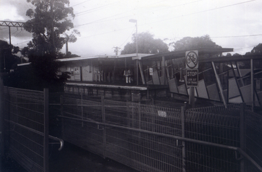
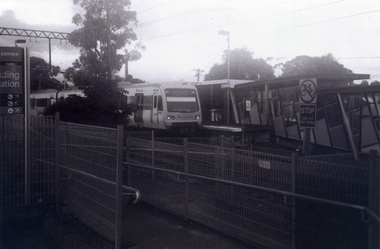
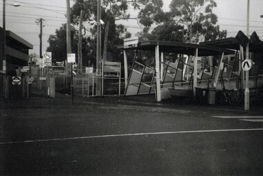
... the Nunawading Station and the Springvale Road Railway crossing... Railway crossing. This photograph is the rear of the liquor store ...One of a collection of photographs taken of the Nunawading Railway Station prior to the lowering of the railway line and building of the new railway station on the western side of Springvale Road so that the Springvale Road Rail Crossing can be eliminated.Black & white photograph of the precinct surrounding the Nunawading Station and the Springvale Road Railway crossing. This photograph is the rear of the liquor store in Springvale Road.cSee NP 3545 to NP3567for the complete set of photographsnunawading railway station, springvale road nunawading, redevelopment of railway line/springvale road. -
 Tatura Irrigation & Wartime Camps Museum
Photograph, Hogan Street Tatura at night
... Photograph of Hogan Street, Tatura, east of railway... of railway crossing with street lighting. Hogan Street, Tatura ...Photograph of Hogan Street, Tatura, east of railway crossing with street lighting.Black and white photograph of Hogan Street, Tatura at night.on back: Hogan Street, Tatura, east of railway stationhogan street, tatura -
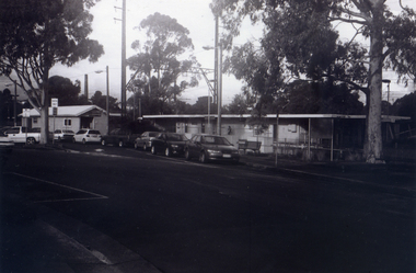
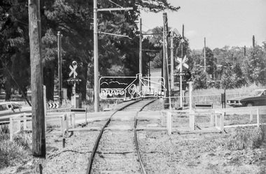
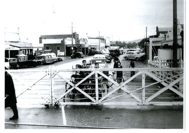 Wodonga & District Historical Society Inc
Photograph - High Street, Wodonga Level Crossing, 1954
... , it was replaced by boom gates and flashing lights. The railway crossing...A black and white photo of the railway level crossing... and flashing lights. The railway crossing was removed from High Street ...This image is representative of many photographs illustrating the level crossing in the centre of Wodonga. Since its opening in 1873 the railway line had crossed High Street, originally called Sydney Road. It bisected the city with level crossing gates frequently stopping the flow of traffic and pedestrians as trains passed through. Signal Box B stood on the eastern side of the High Street level crossing and a big wheel closed and opened the gates. On 17th September, 1961, it was replaced by boom gates and flashing lights. The railway crossing was removed from High Street as part of the Wodonga Rail Bypass project. This involved a 5.5 kilometres bypass, the elimination of 11 level crossings and the relocation of the Wodonga station. It was moved from its original central location to a position on a new line on the northern edge of the town. The old station closed on 8 November 2008 and the new station opened on 25 June 2011.This image has local and statewide significance as it captures the former crossing in a major railway system. The railways played a critical role in opening up Victoria and connecting Australia for trade, business, social communication and transport.A black and white photo of the railway level crossing in High Street, Wodonga with gates closed. The Melbourne to Sydney railway line went through the centre of Wodonga and trains frequently held up internal vehicular and pedestrian traffic in the main street. railways wodonga, wodonga railway relocation, high st wodonga rail crossing -
 Tatura Irrigation & Wartime Camps Museum
Photograph - copy, Hogan Street c.1985
... from railway crossing...., looking west from railway crossing. Hogan Street c.1985 Photograph ...Borrowed for scanning. Hogan Street c.1985, looking west from railway crossing. -
Stawell Historical Society Inc
Archive - USB Stick, Scenes Of Stawell 1968, 1968
... , Railway Crossing, cars in 1968..., Railway Crossing, cars in 1968 1968 Stawell Scenes Pink USB Stick ...Main Street. Wimmera Street. Railway Station, Trains, Railway Crossing, cars in 1968Pink USB Stick1968 Stawell Scenes -
 Whitehorse Historical Society Inc.
Photograph, Railway Platform from south side, 1/06/2009
... the Nunawading Station and the Springvale Road Railway crossing... Railway crossing. This photograph is railway station looking from ...One of a collection of photographs taken of the Nunawading Railway Station prior to the lowering of the railway line and building of the new railway station on the western side of Springvale Road so that the Springvale Road Rail Crossing can be eliminated.Black & white photograph of the precinct surrounding the Nunawading Station and the Springvale Road Railway crossing. This photograph is railway station looking from north side of station. See NP 3545 to NP3567 for the complete set of photographsnunawading railway station, springvale road nunawading, redevelopment of railway line/springvale road. -
 Hume City Civic Collection
Photograph
... of the duplication of the Calder Highway between the Railway crossing... of the duplication of the Calder Highway between the Railway crossing ...The old Calder Highway before the construction of the duplication of the Calder Highway between the Railway crossing and Plumpton Road.A coloured panoramic view of the old Caler Highway at Diggers Rest. It is unmounted.old calder highway, diggers rest, plumpton road, railways, george evans collection -
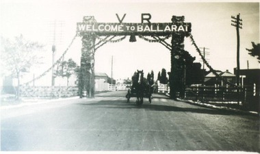 City of Ballarat Libraries
Photograph, Decorative Arch over Creswick Road Rail Crossing for Ballarat Centenary Celebrations 1938
... railway crossing for the Ballarat Centenary Celebrations in 1938.... the Creswick Road railway crossing for the Ballarat Centenary ...Victorian Railways Decorative arch over the Creswick Road railway crossing for the Ballarat Centenary Celebrations in 1938.streetscape, centenary, ballarat, creswick road, railway -
 Tatura Irrigation & Wartime Camps Museum
Photograph, Hogan and Walshe Streets
... . Park clock tower and railway crossing, c.1950.... Office, Dr. Park clock tower and railway crossing, c.1950. Hogan ...Hogan and Walshe Streets intersection with Post Office, Dr. Park clock tower and railway crossing, c.1950. -
 Whitehorse Historical Society Inc.
Photograph, Nunawading Railway Station, 1/06/2009
... the Nunawading Station and the Springvale Road Railway crossing... the Nunawading Station and the Springvale Road Railway crossing ...One of a collection of photographs taken of the Nunawading Railway Station prior to the lowering of the railway line and building of the new railway station on the western side of Springvale Road so that the Springvale Road Rail Crossing can be eliminated.Black & white photograph of he precinct surrounding the Nunawading Station and the Springvale Road Railway crossing. This photograph is of the southern entrance from Station Street. Note the Grenda Bus|See NP 3545 to NP3567for the complete set of photographsnunawading railway station, springvale road nunawading, redevelopment of railway line/springvale road., station street nunawading -
 Whitehorse Historical Society Inc.
Photograph, Nunawading Station looking from the north side, 1/06/2009
... the Nunawading Station and the Springvale Road Railway crossing... and the Springvale Road Railway crossing. This photograph is the station ...One of a collection of photographs taken of the Nunawading Railway Station prior to the lowering of the railway line and building of the new railway station on the western side of Springvale Road so that the Springvale Road Rail Crossing can be eliminated.Black & white photograph of he precinct surrounding the Nunawading Station and the Springvale Road Railway crossing. This photograph is the station looking from the entrance of station on the north side of the tracks. See NP 3545 to NP3567 for the complete set of photographsnunawading railway station, springvale road nunawading, redevelopment of railway line/springvale road. -
 Whitehorse Historical Society Inc.
Photograph, Looking to Booking Office on North side of Nunawading Station, 1/06/2009
... the Nunawading Station and the Springvale Road Railway crossing... and the Springvale Road Railway crossing. This photograph is the entrance ...One of a collection of photographs taken of the Nunawading Railway Station prior to the lowering of the railway line and building of the new railway station on the western side of Springvale Road so that the Springvale Road Rail Crossing can be eliminated.Black & white photograph of he precinct surrounding the Nunawading Station and the Springvale Road Railway crossing. This photograph is the entrance to the Booking Office for trains from Nunawading travelling east. See NP 3545 to NP3567 for the complete set of photographsnunawading railway station, springvale road nunawading, redevelopment of railway line/springvale road. -
 Whitehorse Historical Society Inc.
Photograph, Nunawading Station - North Side, 1/06/2009
... the Nunawading Station and the Springvale Road Railway crossing... and the Springvale Road Railway crossing. This photograph is of the Booking ...One of a collection of photographs taken of the Nunawading Railway Station prior to the lowering of the railway line and building of the new railway station on the western side of Springvale Road so that the Springvale Road Rail Crossing can be eliminated.Black & white photograph of he precinct surrounding the Nunawading Station and the Springvale Road Railway crossing. This photograph is of the Booking Office and Waiting Rooms on the North side of the Nunawading Station . See NP 3545 to NP3567 for the complete set of photographsnunawading railway station, springvale road nunawading, redevelopment of railway line/springvale road. -
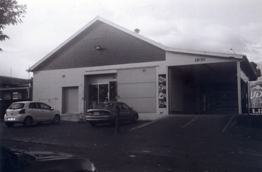
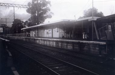
 City of Ballarat Libraries
Photograph - Card Box Photographs, Ballarat Railway Station from the Lydiard Street North Signal Box
... A train goes through the railway crossing on Lydiard Street... Ballarat East goldfields A train goes through the railway crossing ...A train goes through the railway crossing on Lydiard Street North. The photograph may have been taken between 1900-1906.ballarat railway station, lydiard street north, building, vehicles, persons -
 Whitehorse Historical Society Inc.
Photograph, Nunawading Railway Station, 1/06/2009 12:00:00 AM
... the Nunawading Station and the Springvale Road Railway crossing... of the Nunawading Railway Station prior to the lowering of the railway line ...One of a collection of photographs taken of the Nunawading Railway Station prior to the lowering of the railway line and building of the new railway station on the western side of Springvale Road so that the Springvale Road Rail Crossing can be eliminated.Black & white photograph of he precinct surrounding the Nunawading Station and the Springvale Road Railway crossing. This photograph is A close up of the southern entrance to the Nunawading Station from Station Street. See NP 3545 to NP3567for the complete set of photographsnunawading railway station, springvale road nunawading, station street nunawading -
 Whitehorse Historical Society Inc.
Photograph, Station seen from north side-Platform, 1/06/2009
... the Nunawading Station and the Springvale Road Railway crossing... and the Springvale Road Railway crossing. This photograph is a close up view ...One of a collection of photographs taken of the Nunawading Railway Station prior to the lowering of the railway line and building of the new railway station on the western side of Springvale Road so that the Springvale Road Rail Crossing can be eliminated.Black & white photograph of he precinct surrounding the Nunawading Station and the Springvale Road Railway crossing. This photograph is a close up view of the south platform at Nunawading from the north side.|See NP 3545 to NP3567for the complete set of photographsnunawading railway station, springvale road nunawading, redevelopment of railway line/springvale road. -
 Whitehorse Historical Society Inc.
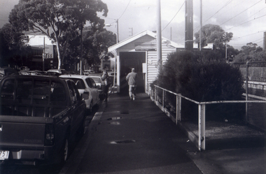
Photograph, Site Office for the Construction of new crossing and station, 1/06/2009
... the Nunawading Station and the Springvale Road Railway crossing... Railway crossing. This photograph is of the Site Office ...One of a collection of photographs taken of the Nunawading Railway Station prior to the lowering of the railway line and building of the new railway station on the western side of Springvale Road so that the Springvale Road Rail Crossing can be eliminated. Black & white photograph of the precinct surrounding the Nunawading Station and the Springvale Road Railway crossing. This photograph is of the Site Office for the work associated with lowering of railway line and construction of new railway station. See NP 3545 to NP3567for the complete set of photographsnunawading railway station, redevelopment of railway line/springvale road., springvale road nunawading -
 Whitehorse Historical Society Inc.
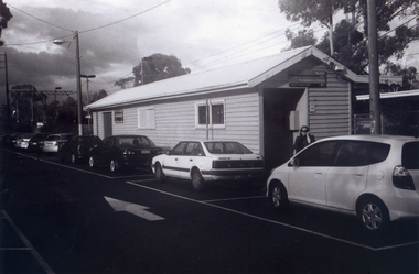
Photograph, Service Station -Now Works Site Office, 1/06/2009
... the Nunawading Station and the Springvale Road Railway crossing... and the Springvale Road Railway crossing. This photograph is former Service ...One of a collection of photographs taken of the Nunawading Railway Station prior to the lowering of the railway line and building of the new railway station on the western side of Springvale Road so that the Springvale Road Rail Crossing can be eliminated.Black & white photograph of he precinct surrounding the Nunawading Station and the Springvale Road Railway crossing. This photograph is former Service Station on west side of Springvale Road. Now works site office. See NP 3545 to NP3567 for the complete set of photographsnunawading railway station, springvale road nunawading, redevelopment of railway line/springvale road. -
 Whitehorse Historical Society Inc.
Photograph, General View of Nunawading Station, 1/06/2009
... the Nunawading Station and the Springvale Road Railway crossing... the Nunawading Station and the Springvale Road Railway crossing ...One of a collection of photographs taken of the Nunawading Railway Station prior to the lowering of the railway line and building of the new railway station on the western side of Springvale Road so that the Springvale Road Rail Crossing can be eliminated.Black & white photograph of he precinct surrounding the Nunawading Station and the Springvale Road Railway crossing. This photograph is view of the Nunawading Railway Station from Walker Road, showing the North an South Platforms. See NP 3545 to NP3567 for the complete set of photographsnunawading railway station, springvale road nunawading, redevelopment of railway line/springvale road., walkers road nunawading -
Port Melbourne Historical & Preservation Society
Plan - Traffic census, Port Melbourne, 6 Mar 1947
... ) Williamstown Road and Beach Road (no 112), Railway Crossing Graham... Road (no 112), Railway Crossing Graham Street (no 77) Plan ...Traffic census 6th March 1947 showing intersections at Ingles Street and Williamstown Road (no 84), Lorimer Street and Salmon Street )no 90) Beach Street and Bay Street (no 113) Williamstown Road and Beach Road (no 112), Railway Crossing Graham Street (no 77)engineering - roads streets lanes and footpaths -
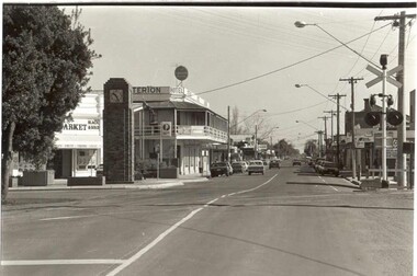
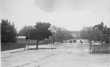 Stawell Historical Society Inc
Photograph, Lower Main Street Stawell looking East c1905. Merle Photographic Studio at Left
... the Diamond house looking down Seaby St. toward the railway crossing.... the Diamond house looking down Seaby St. toward the railway crossing ...Lower Main Street looking East from Railway gates. Shows four horse drawn vehicles. The photo was taken from the railway gates towards the main shopping area. The Presbyterian spire can be seen in the back ground. c1905.Sepia Postcard of a street scene the roadway is central in picture featuring 4 horse drawn vehicles. Street is tree lined with picket fence on right side of photograph. 0007a taken opposite the Diamond house looking down Seaby St. toward the railway crossing.Lower Main Street Stawell No 10. is inscribed on the front and The "Merle Studio" Main Street, Stawell on the back.stawell shops business streetscape building transport -
 Ballarat Tramway Museum
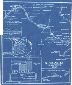
Drawing, "Newcastle Tramways 1938", 1938
... Tramways in 1938 Has depot layouts, railway crossings, street... Tramways in 1938 Has depot layouts, railway crossings, street names ...Blue print drawings titled ""Newcastle Tramways 1938" printed on two sheets showing the track layout for the Newcastle Tramways in 1938 Has depot layouts, railway crossings, street names and major waterways. From the Wal Jack Collection. No details of made them.wal jack, newcastle, track layout -
Tatura Irrigation & Wartime Camps Museum
Photographs, Hogan Street Tatura
... 1. Hogan Street looking west from railway crossing c.1900... Tatura the-murray 1. Hogan Street looking west from railway ...1. Hogan Street looking west from railway crossing c.1900.|2. Hogan Street looking east from Ross Street, c.1900, Flanagan's Store.2 photos -
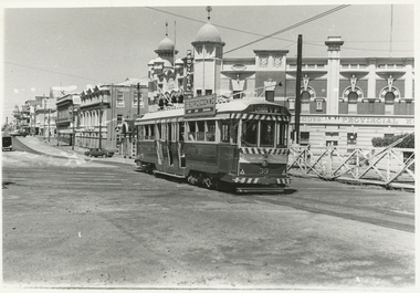 Ballarat Tramway Museum
Photograph - Black & White Photograph/s, J. L. Southern Collection, late 1960's?
... in Lydiard St Nth, mid 1960s, crossing railway level crossing. Tram... of Ballarat where trams crossed the railway level crossing in Lydiard ...Demonstrates an aspect of Ballarat where trams crossed the railway level crossing in Lydiard St Nth.Black and White photograph of No. 39, north bound in Lydiard St Nth, mid 1960s, crossing railway level crossing. Tram has SEC roof advertisement of "Electric Cooking" and destination of Lydiard St Nth. Note the two numbers on the front of the tram - see also reg item 3601 for a 1969 photograph in the same location. Moody's Provincial Hotel in the background and the railway level crossing. in pencil on back "04381003"tramways, trams, railway station, level crossings, lydiard st nth, provincial hotel, tram 39 -
 Eltham District Historical Society Inc
Photograph, George Coop, Newport Signal Box, Newport Railway Station, c.1951
... melbourne Now demolished. Newport Railway station, visible through ...Now demolished. Newport Railway station, visible through the windows was situated on the opposite side of the Melbourne Road level crossing. All of this infrastructure has since been replaced by a large overpass, the level crossing now the location of a pedestrain underpass. One of several photos at Newport taken the same day in the early 1950s when George Coop was a secondary school student.Digital TIFF file Scan of Kopdak 620 black and white negative transparencygeorge coop collection, newport railway station, level crossing, melbourne road, newport signal box -
 Eltham District Historical Society Inc
Photograph, George Coop, Level crossing at the Main Hurstbridge Road on the approach to Diamond Creek Railway Station, 6 December 1980, 1980
... Diamond Creek Railway Station, Level Crossing, Main... melbourne View from driver's cabin Diamond Creek Railway Station ...View from driver's cabinDigital TIFF file Scan of 35mm Ilford FP4 black and white transparencydiamond creek railway station, level crossing, main hurstbridge road