Showing 110536 items
matching roads
-
 Eltham District Historical Society Inc
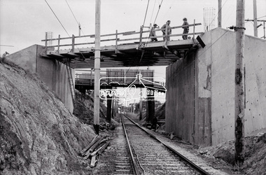
Negative - Photograph, Russell Yeoman, New road bridge under construction over railway line at junction of Sherbourne and Para Roads, Briar Hill, 1971
... junction of Sherbourne and Para Roads, Briar Hill. ...New bridge in foreground. Old bridge in background before demolition. This photo forms part of a collection of photographs gathered by the Shire of Eltham for their centenary project book,"Pioneers and Painters: 100 years of the Shire of Eltham" by Alan Marshall (1971). The collection of over 500 images is held in partnership between Eltham District Historical Society and Yarra Plenty Regional Library (Eltham Library) and is now formally known as the 'The Shire of Eltham Pioneers Photograph Collection.' It is significant in being the first community sourced collection representing the places and people of the Shire's first one hundred years.Digital image 35 mm B&W negativesepp, shire of eltham pioneers photograph collection, montmorency, briar hill, bridge, para road, railway bridge, railway line, road construction, sherbourne road, bridge construction -
 Federation University Historical Collection
Map, Map of Vitilevu showing vehicular roads, native tracks, villages, provinces, 1935
... Map of Vitilevu showing vehicular roads, native tracks ...Printed map on paper backed onto linen with small inset maps of Nandi and Singatoka map, vitilevu, singatoka, nandi -
 Victorian Aboriginal Corporation for Languages
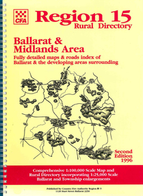
Map, Country Fire Authority, Region 15 rural directory : Ballarat &? Midlands Area : fully detailed maps &? roads index of Ballarat &? the developing areas surrounding, 1996
... : fully detailed maps &? roads index of Ballarat &? the developing ...mapsballarat, fire protection, victorian regional maps, emergency services -
 Victorian Aboriginal Corporation for Languages
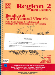
Map, Country Fire Authority, Region 2 rural directory : Bendigo &? North Central Victoria: fully detailed maps &? roads index of Bendigo &? the developing areas surrounding, 1996
... Victoria: fully detailed maps &? roads index of Bendigo &? the ...mapsbendigo, loddon, fire protection, victorian regional maps, directories -
University of Melbourne, Burnley Campus Archives
Document - Report, Revised roads plan for Burnley Gardens and Report to accompany Master Plan of Burnley Gardens, 1949-1951
... Revised roads plan for Burnley Gardens and Report to ...2 documents containing the report by E.M. Gibsontucker, e. m. gibson, administration building construction -
 Yarrawonga and Mulwala Pioneer Museum
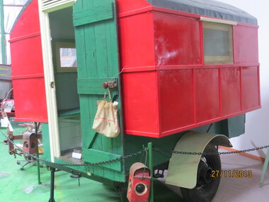
Caravan, Country Roads Board Caravan, 1940's
... Country Roads Board Caravan ...Used in the Yarrawonga District in the 1940's and restored by Bill Church Dec 2000 A box-like caravan on 2 wheels which was towed to the job and catered for two employees to live in until the job was completed -
Whitehorse Historical Society Inc.
Article, Another 1.5 million pounds for roads, 1964
... Another 1.5 million pounds for roads ...City of Nunawading's roadmaking program,City of Nunawading's roadmaking program, including lists of streets affected. City of Nunawading's roadmaking program,city of nunawading, road construction and maintenance -
 Whitehorse Historical Society Inc.
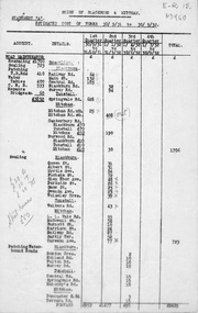
Document, Roads, ca 1932
... Roads ...Shire of Blackburn and Mitcham Statement 'A'. Estimated cost of works 30/9/31 to 30/9/32.roads and streets, local government, shire of blackburn and mitcham -
 Whitehorse Historical Society Inc.
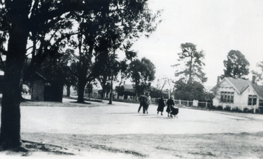
Photograph, Vermont Corner Canterbury and Boronia Roads Vermont
... Vermont Corner Canterbury and Boronia Roads Vermont. ...Black and white photo of Vermont corner showing the State Schoolvermont corner, canterbury rd. vermont, vermont state school -
 Ballarat Tramway Museum
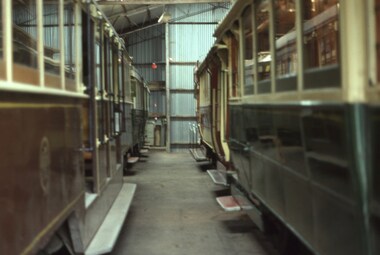
Slide - 35mm slide/s, David Verrier, View between 2 and 3 roads Ballarat Museum depot, 26/04/1975
... View between 2 and 3 roads Ballarat Museum depot ...Photo of the first horse drawn tower wagon at Sovereign Hill. This item was offered to the BTPS but declined as it did not have the storage space for it. Understood to have later been dismantled.Yields information about the appearance of the horse drawn tower wagon of ESCo.Agfa colour slide, white blue plastic mount. Photo by David Verrier.On back of slide in inktramways, trams, tower wagon, sovereign hill, cotma -
 Ballarat Tramway Museum
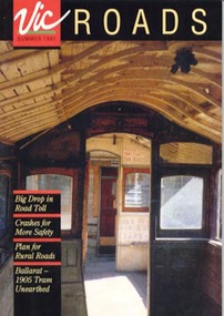
Magazine, Corporate Affairs Section of VicRoads, Vic Roads - Summer 1991, 1991
... Vic Roads - Summer 1991 ...32 page periodical featuring photos and article on recovery of ESCo tram No. 12 in 1991. House magazine of VicRoads, colour interior photos of No. 12 on cover and on pages 18 and 19, further colour photos of and article. Summer 1991 Edition 268.4 - copy made for No. 12 display - 3/99. Two copies from Warren Doubleday's personal collection added 11/6/2010 and record revised.trams, tramways, tram recovery, btps, ballarat trams, recovery, esco -
 University of Melbourne, Burnley Campus Archives
Plan, E.M. Gibson, Revised Roads Plan for Burnley Gardens, 1951
... Revised Roads Plan for Burnley Gardens ...(1) 8 copies Plan by E.M. Gibson. (2) Report to Accompany Master Garden Plan for Burnley Gardens by E.M. Gibson 1.12.1949. Includes all areas around new Administration Building. Refers to help from C.R.T.S. students. Note: Master Garden Plan itself not found.e.m. gibson, burnley gardens, crts, students -
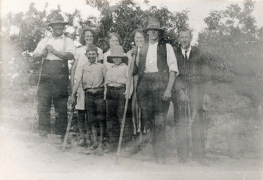 Wonga Park Community Cottage History Group
Photograph (sub-item) - Black and White, Heims family picking fruit on their property near corner of Toppings and Homestead Roads in 1930’s
... Toppings and Homestead Roads in 1930’s ... -
Wonga Park Community Cottage History Group
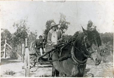
Negative (Item) - Negative of a photo, Mrs. Sharpe in her horse-drawn cart, 1919, at the corner of Jumping Creek and Hartley Roads
... Jumping Creek and Hartley Roads. ... -
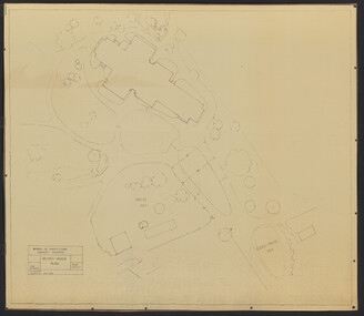
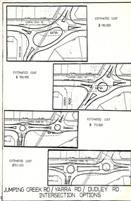 Wonga Park Community Cottage History Group
Work on paper (Item) - Plan, Wonga Park: Four Options for development of Jumping Creek, Yarra and Dudley Roads corner c. 1983
... , Yarra and Dudley Roads corner c. 1983 ...Prepared by the Shire of Lillydale during discussion with Wonga Park & District Residents' Association regarding the redevelopment of the intersection -
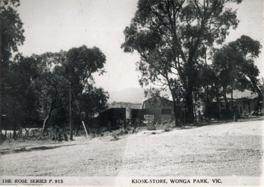 Wonga Park Community Cottage History Group
Photograph (sub-item) - Black and White, The Kiosk/Store in Wonga Park about 1948, owned by Mr. Arthur Davis. This view is from the intersection of Yarra and Jumping Creek Roads
... Jumping Creek Roads. ... -
 Wonga Park Community Cottage History Group
Photograph (sub-item) - Black and White, Mrs. Sharpe in her horse-drawn cart, 1919, at the corner of Jumping Creek and Hartley Roads
... Jumping Creek and Hartley Roads. ... -
Linton Mechanics Institute and Free Library Collection
Book - Novel, Black, Hermina, Love's cross-roads, 1953
... Love's cross-roads ...Romance fiction set in Rhodesia.176 p. : blue-green cover. section of original dust jacket has been pasted to front. Image shows a rural setting which suggests Africa, a woman is in the foreground with a man (possibly holding a gun) standing behind her.fictionRomance fiction set in Rhodesia.fiction, hermina black -
 Victorian Railway History Library
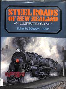
Book, Troup, Gordon, Steel Roads of New Zealand - An Illustrated Survey, 1973
... Steel Roads of New Zealand - An Illustrated Survey ...An illustrated description of the New Zealand Railways up to 1973.index, ill, maps, p.342.non-fictionAn illustrated description of the New Zealand Railways up to 1973.railroads -- new zealand -- history., history of railways - new zealand -
Vision Australia
Audio - Sound recording, 94.7 The Pulse Roads to Recovery with Greg McHenry and Noel Read, 05/08/2008
... 94.7 The Pulse Roads to Recovery with Greg McHenry and Noel ...Community Radio station 94.7 The Pulse speaks with Noel Read about Vision Australia and his experiences with the organisation as a client and an employer.1 CD with single trackvision australia, greg mchenry, noel read -
 Whitehorse Historical Society Inc.
Document - Webpage, VicRoads, Victorian Roads Number Plates, 2014, and 2021 updated version
... Victorian Roads Number Plates ...Victorian car, truck and motorcycle number plates and for the years 1960 to 2014 have been printed from the VicRoads website, supplemented by further brief notes describing the plates from 1930. An updated list of car plates is also included with an updated plate number for 2014 and a further 4 years between 2015-2018.Victorian car, truck and motorcycle number plates for the years 1960 to 2014 have been printed from the VicRoads website, supplemented by further brief notes describing the plates. An updated list of car plates is also included with an updated plate number for 2014 and a further 4 years between 2015-2018. non-fictionVictorian car, truck and motorcycle number plates and for the years 1960 to 2014 have been printed from the VicRoads website, supplemented by further brief notes describing the plates from 1930. An updated list of car plates is also included with an updated plate number for 2014 and a further 4 years between 2015-2018. number plates, car, truck, motorcycle -
Linton Mechanics Institute and Free Library Collection
Book - Novel, Dell, Ethel M, Where three roads meet, 1935
... Where three roads meet ...Romance fiction424 p. fictionRomance fictionfiction, romance, ethel m. dell -
 Greensborough Historical Society
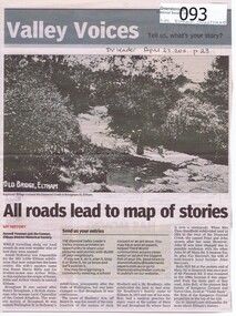
Newspaper - Newspaper clipping, All roads lead to map of stories, 27/04/2011
... All roads lead to map of stories ...Family history of Josiah Holloway, origins of street names in the subdivision of Eltham History of Eltham and origins of street names connected with pioneers of the area.Newsprint, gray scale. Photograph of Keylock's Bridge on Diamond Creek at ElthamDV Leader April27 2011, p23josiah holloway, jack shallard, susanna maria bible, bradbury, henry brougham, handfield, fay harcourt, violet bank, kangaroo ground, bells hillroad, shalbury avenue, beard street, brougham street, main road, eltham -
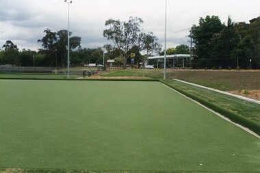
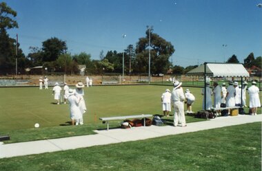
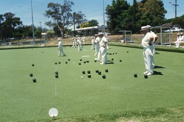
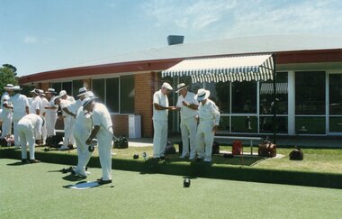
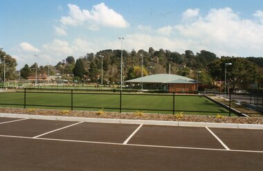
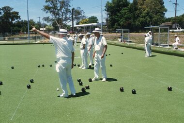
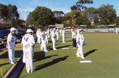 Ringwood and District Historical Society
Photograph, Ringwood Bowls Club - New club house and greens at the corner of Warrandyte and Loughnan Roads, 1997. Photo taken by Jim Bennett
... corner of Warrandyte and Loughnan Roads, 1997. Photo taken by Jim ...Coloured photograph -
 Ringwood and District Historical Society
Photograph, Ringwood Bowls Club - New club house and greens at the corner of Warrandyte and Loughnan Roads, 1997. Photo taken by Jim Bennett
... corner of Warrandyte and Loughnan Roads, 1997. Photo taken by Jim ...Coloured photograph -
 Ringwood and District Historical Society
Photograph, Ringwood Bowls Club - New club house and greens at the corner of Warrandyte and Loughnan Roads, 1997. Photo taken by Jim Bennett
... corner of Warrandyte and Loughnan Roads, 1997. Photo taken by Jim ...Coloured photograph -
 Ringwood and District Historical Society
Photograph, Ringwood Bowls Club - New club house and greens at the corner of Warrandyte and Loughnan Roads, 1997. Photo taken by Jim Bennett
... corner of Warrandyte and Loughnan Roads, 1997. Photo taken by Jim ...Coloured photograph -
 Ringwood and District Historical Society
Photograph, Ringwood Bowls Club - New club house and greens at the corner of Warrandyte and Loughnan Roads, 1997. Photo taken by Jim Bennett
... corner of Warrandyte and Loughnan Roads, 1997. Photo taken by Jim ...Coloured photograph -
 Ringwood and District Historical Society
Photograph, Ringwood Bowls Club - New club and greens at the corner of Warrandyte and Loughnan Roads, 1997. Photo taken by Jim Bennett
... Warrandyte and Loughnan Roads, 1997. Photo taken by Jim Bennett. ...Coloured photograph -
 Ringwood and District Historical Society
Photograph, Ringwood Bowls Club - New club house and greens at the corner of Warrandyte and Loughnan Roads, 1997. Photo taken by Jim Bennett
... corner of Warrandyte and Loughnan Roads, 1997. Photo taken by Jim ...Coloured photograph