Showing 40723 items
matching roads and streets
-
 Bendigo Historical Society Inc.
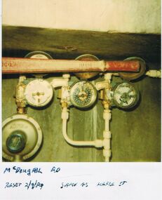
Photograph - CASTLEMAINE GAS COMPANY COLLECTION: PHOTO MCDOUGALL ROAD, 02/09/1989
McDougall Road Reset - 02/09/1989 Same as Maple StreetPolaroidorganisation, industry, gas and fuel -
 University of Melbourne, Burnley Campus Archives
Photograph - Black and white print, 631/2/5, 1947
Road to Swan Street from College. "N Easter 1947." EMGswan street, e. m. gibson collection -
Canterbury History Group
Photograph - Street view of 2 shops in Canterbury Road, Canterbury, Stuart Warmington, 1994
Coloured photograph of street view of 2 shops in Canterbury Road, Canterburycanterbury, canterbury road, shops -
Canterbury History Group
Photograph - Street view of 2 shops in Canterbury Road, Canterbury, Stuart Warmington, 1994
Coloured photograph of street view of 2 shops in Canterbury Road, Canterburycanterbury, canterbury road, shops, victorian architectural designs -
Canterbury History Group
Photograph - Street view of business at No. 141 Maling Road, Canterbury, Stuart Warmington, 1995
Coloured photograph of street view of business at No. 141 Maling Road, Canterburycanterbury, maling road, shops -
Canterbury History Group
Photograph - Street view of shop No.135 Maling Road, Canterbury, Stuart Warmington, 1995
Coloured photograph of street view of shop No.135 Maling Road, Canterburycanterbury, maling road, shops -
Canterbury History Group
Photograph - Street view of shop No.139 Maling Road, Canterbury, Stuart Warmington, 1995
Coloured photograph of street view of shop No.139 Maling Road, Canterburycanterbury, maling road, shops -
Canterbury History Group
Photograph - Street view of shop No.137 Maling Road, Canterbury, Stuart Warmington, 1995
Coloured photograph of street view of shop No.137 Maling Road, Canterburycanterbury, maling road, shops -
Canterbury History Group
Photograph - Street view of shop No.131 Maling Road, Canterbury, Stuart Warmington, 1995
Coloured photograph of street view of shop No.131 Maling Road, Canterburycanterbury, maling road, shops -
Canterbury History Group
Photograph - Street view of shop No.131 Maling Road, Canterbury, Stuart Warmington, 1995
Coloured photograph of street view of shop No.131 Maling Road, Canterburycanterbury, maling road, shops -
Canterbury History Group
Photograph - Street view of 2 shops in Maling Road, Canterbury, Stuart Warmington, 1995
Coloured photograph of street view of 2 shops in Maling Road, Canterburycanterbury, maling road, shops -
Canterbury History Group
Photograph - Street view of shop No. 123 Maling Road Canterbury, Stuart Warmington, 1995
Coloured photograph of street view of shop No. 123 Maling Road Canterburycanterbury, maling road, shops -
Canterbury History Group
Photograph - Street view of shop No. 125 Maling Road Canterbury, Stuart Warmington, 1995
Coloured photograph of street view of shop No. 125 Maling Road Canterburycanterbury, maling road, shops -
Canterbury History Group
Photograph - Street view of the business at No. 121 Maling Road, Canterbury, Stuart Warmington, 1995
Coloured photograph of street view of the business at No. 121 Maling Road, Canterburycanterbury, maling road, shops, banks -
Canterbury History Group
Photograph - Street view of the business at No. 121 Maling Road, Canterbury, Stuart Warmington, 1995
Coloured photograph of street view of the business at No. 121 Maling Road, Canterburycanterbury, maling road, shops, banks -
Canterbury History Group
Photograph - Street view of the business at No. 119 Maling Road, Canterbury, Stuart Warmington, 1995
Coloured photograph of street view of the business at No. 119 Maling Road, Canterburycanterbury, maling road, shops -
Canterbury History Group
Photograph - Street view of the shop at No.111 Maling Road, Canterbury, Stuart Warmington, 1995
Coloured photograph of street view of the shop No. 111 Maling Road, Canterburycanterbury, maling road, shops -
Canterbury History Group
Photograph - Street view of the shop No.113 Maling Road, Canterbury, Stuart Warmington, 1995
Coloured photograph of street view of the shop No.113 Maling Road, Canterburycanterbury, maling road, shops -
Canterbury History Group
Photograph - Street view of Bradshaw's Garage in Maling Road, Canterbury, Stuart Warmington, 1995
Coloured photograph of street view of Bradshaw's Garage in Maling Road, Canterburycanterbury, maling road, shops -
Canterbury History Group
Photograph - Street view of Bradshaw's Garage in Maling Road, Canterbury, Stuart Warmington, 1995
Coloured photograph of street view of Bradshaw's Garage in Maling Road, Canterburycanterbury, maling road, shops -
Canterbury History Group
Document - Land Title, 162 Canterbury Road Canterbury, 2018
History of the ownership of the land corner of Canterbury Road & Keats Street Canterburysoldiers' memorial hall, keats street, canterbury road, logan> margaret, logan> michael, malone> william, mcgee> peter rev., balloch> john, balloch> robert johnston, hay> james, hoskin> william thomas, salvation army, gates> william fleming, coghill> george -
 Pyrenees Shire Council
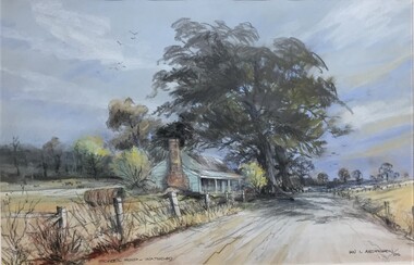
painting, Ian L Anderson, School Road, Waterloo by Ian L Anderson, 1995
significant as a work of art by local Pyrenees artist, locally significant to the Central Highlands Region of Victoria as a representation of local landscape and/or culture pastel drawing of a street scene with old house, trees and unpaved road"Signed: IAN L ANDERSON 95 (lower right) Titled: SCHOOL ROAD - WATERLOO (lower centre) Verso (affixed): ""SCHOOL ROAD - WATERLOO"" PASTEL AND CHARCOAL PENCIL PAINTING by IAN L. ANDERSON 14 MILLAR CRESCENT MT WAVERLEY 3145 signed: Ian Anderson '95 $500" -
Canterbury History Group
Photograph - Old Timber House in Maling Road, Jan Pigot, 1992
Part of a set of 8 coloured photographs taken by Jan Pigot to record the demolition of some buildings in Maling Road to make way for new shops and car park.Old timber house on corner of Scott Street and Maling Road 1992. canterbury, maling road, timber house, scott street, shopping centres -
Canterbury History Group
Photograph - Street view of shops around No. 175 Canterbury Road, Jan Pigot, 1994
Coloured photograph of the street view of shops around No. 175 Canterbury Roadcanterbury, canterbury road, shops, signs -
Canterbury History Group
Photograph - Street view of shop around No. 181 Canterbury Road, Jan Pigot, 1994
Coloured photograph of the street view of shop around No. 181 Canterbury Roadcanterbury, canterbury road, shops -
Canterbury History Group
Photograph - Street view of shops around No. 185 Canterbury Road, Jan Pigot, 1994
Coloured photograph of the street view of shops around No. 185 Canterbury Roadcanterbury, canterbury road, shops -
Canterbury History Group
Photograph - Street view of the Bank at No. 121 Maling Road, Jan Pigot, 27/03/1993 12:00:00 AM
Coloured photograph of of the street view of the Commonwealth Bank at No. 121 Maling Roadcanterbury, maling road, shops, streetscapes, banks -
 Ringwood and District Historical Society
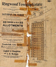
Flyer, Auction Sale Advertisements - Ringwood Township Estate, Ringwood, Victoria - 1914
Advertisements for auction sale of Ringwood Township Estate (Section A) - Saturday, 7th March (1914), showing subdivision layout, terms of sale, and summary of local features and services. Un-named newspaper clipping advertising this auction also attached.Subdivision includes West Prussia Road (later Wantirna Road), Station Street, and James Street. Agents in conjunction - Coghill & Haughton and J.B. McAlpin. Sale by order of Mrs. E. Kendall. -
 Glen Eira Historical Society
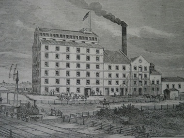
Railways in Caulfield
Photocopy of Rosstown Sugerworks and railway built in 1876 on corner of what is now Miller Street, Neville Street and Koornang Roadcarnegie, rosstown sugerworks, miller street, neville street, koornang road, railways -
 Marysville & District Historical Society
Photograph (Item) - Colour photograph, Travel Victoria, 2006
A colour photograph of Murchison Street in Marysville in Victoria.A colour photograph of Murchison Street in Marysville in Victoria.murchison street, marysville, victoria, photograph