Showing 308 items
matching stage show
-
 Kew Historical Society Inc
Map - Subdivision Plan, Grenville Estate, 1922
... attraction. The plan shows how at this stage A regrettable aspect... was publicised as an added attraction. The plan shows how at this stage ...Pru Sanderson, in her groundbreaking ‘City of Kew Urban Conservation Study : Volume 2 - Development History’ (1988), summarised the periods of urban development and subdivisions of land in Kew. The periods that she identified included 1845-1880, 1880-1893, 1893-1921, 1921-1933, 1933-1943, and Post-War Development. These periods were selected as they represented periods of rapid growth or decline in urban development. An obvious starting point for Sanderson’s groupings involved population growth and the associated economic cycles. These cycles also highlighted urban expansion onto land that was predominantly rural, although in other cases it represented the decline and breakup of large estates. A number of the plans in the Kew Historical Society’s collection can also be found in other collections, such as those of the State Library of Victoria and the Boroondara Library Service. A number are however unique to the collection.Subdivision plans are historically important documents used as evidence of the growth of suburbs in Australia. They frequently provide information about when the land was sold on which a built structure was subsequently constructed as well as evidence relating to surveyors and real estate and financial agents. The numerous subdivision plans in the Kew Historical Society's collection represent working documents, ranging from the initial sketches made in planning a subdivision to printed plans on which auctioneers or agents listed the prices for which individual lots were sold. In a number of cases, the reverse of a subdivision plan in the collection includes a photograph of a house that was also for sale by the agent. These photographs provide significant heritage information relating house design and decoration, fencing and household gardens.In advertising the twenty-two sites of the Grenville Estate in Cotham Road and Alfred Street, Kew, the auctioneers emphasised the proximity of the development to shops, schools, and churches. That mansions surrounded the Estate was publicised as an added attraction. The plan shows how at this stage A regrettable aspect of this plan is that it is pasted over, and obscures a real estate photograph by the Kew photographer Josiah Earl Barnes.subdivision plans - kew, grenville estate, glenferrie road, alfred street, thomas street, cotham road -
 Kew Historical Society Inc
Plan, Melbourne & Metropolitan Board of Works : Borough of Kew : Detail Plan No.1565, 1905
The Melbourne and Metropolitan Board of Works (MMBW) plans were produced from the 1890s to the 1950s. They were crucial to the design and development of Melbourne's sewerage and drainage system. The plans, at a scale of 40 feet to 1 inch (1:480), provide a detailed historical record of Melbourne streetscapes and environmental features. Each plan covers one or two street blocks (roughly six streets), showing details of buildings, including garden layouts and ownership boundaries, and features such as laneways, drains, bridges, parks, municipal boundaries and other prominent landmarks as they existed at the time each plan was produced. (Source: State Library of Victoria). This plan forms part of a large group of MMBW plans and maps that was donated to the Society by the Mr Poulter, City Engineer of the City of Kew in 1989. Within this collection, thirty-five hand-coloured plans, backed with linen, are of statewide significance as they include annotations that provide details of construction materials used in buildings in the first decade of the 20th century as well as additional information about land ownership and usage. The copies in the Public Record Office Victoria and the State Library of Victoria are monochrome versions which do not denote building materials so that the maps in this collection are invaluable and unique tools for researchers and heritage consultants. A number of the plans are not held in the collection of the State Library of Victoria so they have the additional attribute of rarity.Original survey plan, issued by the MMBW to a contractor with responsibility for constructing sewers in the area identified on the plan within the Borough of Kew. The plan was at some stage hand-coloured, possibly by the contractor, but more likely by officers working in the Engineering Department of the Borough and later Town, then City of Kew. The hand-coloured sections of buildings on the plan were used to denote masonry or brick constructions (pink), weatherboard constructions (yellow), and public buildings (grey). MMBW Plan No.1565 is an example of a plan where a number of streets have been created since the area was surveyed, or in other cases renamed. The plan shows those streets that were bordered by Ross Street, Mount Street, Sackville Street and Burke Road. Since 1905, Mawson Street has been created and Mont Albert Road renamed as Dean Street. Named houses on the plan include ‘Tyrol’, ‘Glengorse’, ‘Theodore Villa’, ‘Arncliffe’, ‘Ballynira’ and ‘Hazeldene’. The plan also shows a Wesleyan Church in Sackville Street. In 1883, the Church’s Sunday School celebrated its silver anniversary.melbourne and metropolitan board of works, detail plans, mmbw 1565, cartography -
 Kew Historical Society Inc
Plan, Melbourne & Metropolitan Board of Works : Borough of Kew : Detail Plan No.1570, 1905
The Melbourne and Metropolitan Board of Works (MMBW) plans were produced from the 1890s to the 1950s. They were crucial to the design and development of Melbourne's sewerage and drainage system. The plans, at a scale of 40 feet to 1 inch (1:480), provide a detailed historical record of Melbourne streetscapes and environmental features. Each plan covers one or two street blocks (roughly six streets), showing details of buildings, including garden layouts and ownership boundaries, and features such as laneways, drains, bridges, parks, municipal boundaries and other prominent landmarks as they existed at the time each plan was produced. (Source: State Library of Victoria)This plan forms part of a large group of MMBW plans and maps that was donated to the Society by the Mr Poulter, City Engineer of the City of Kew in 1989. Within this collection, thirty-five hand-coloured plans, backed with linen, are of statewide significance as they include annotations that provide details of construction materials used in buildings in the first decade of the 20th century as well as additional information about land ownership and usage. The copies in the Public Record Office Victoria and the State Library of Victoria are monochrome versions which do not denote building materials so that the maps in this collection are invaluable and unique tools for researchers and heritage consultants. A number of the plans are not held in the collection of the State Library of Victoria so they have the additional attribute of rarity.Original survey plan, issued by the MMBW to a contractor with responsibility for constructing sewers in the area identified on the plan within the Borough of Kew. The plan was at some stage hand-coloured, possibly by the contractor, but more likely by officers working in the Engineering Department of the Borough and later Town, then City of Kew. The hand-coloured sections of buildings on the plan were used to denote masonry or brick constructions (pink), weatherboard constructions (yellow), and public buildings (grey). Plan No.1570 shows the layout of gardens and houses in Sackville Street, Davis Street, Wrixon Street, and Fitzwilliam Street in 1904. While Thomas Street is included on the map, at this stage no houses had been built. The plan identifies two named houses: ‘Fairview’ and ‘Kylemore’. Fairview is more fully delineated in Plan No.1563. Kylemore is one of the few houses in Kew designed by John Beswicke. The most notable owner of Kylemore was William Whitehead, who owned the house between 1895 and 1900. In 1894, Australian newspapers reported the marriage of Whitehead’s daughter to Dr. Gerald Eugene Cussen, the brother of Sir Leo Cussen, the Supreme Court Judge. The married couple was to live at ‘Wilton’ (now the Kew RSL) from 1911-15.melbourne and metropolitan board of works, detail plans, mmbw 1570, cartography -
 Kew Historical Society Inc
Plan, Melbourne & Metropolitan Board of Works : Borough of Kew : Detail Plan No.1572, 1905
The Melbourne and Metropolitan Board of Works (MMBW) plans were produced from the 1890s to the 1950s. They were crucial to the design and development of Melbourne's sewerage and drainage system. The plans, at a scale of 40 feet to 1 inch (1:480), provide a detailed historical record of Melbourne streetscapes and environmental features. Each plan covers one or two street blocks (roughly six streets), showing details of buildings, including garden layouts and ownership boundaries, and features such as laneways, drains, bridges, parks, municipal boundaries and other prominent landmarks as they existed at the time each plan was produced. (Source: State Library of Victoria)This plan forms part of a large group of MMBW plans and maps that was donated to the Society by the Mr Poulter, City Engineer of the City of Kew in 1989. Within this collection, thirty-five hand-coloured plans, backed with linen, are of statewide significance as they include annotations that provide details of construction materials used in buildings in the first decade of the 20th century as well as additional information about land ownership and usage. The copies in the Public Record Office Victoria and the State Library of Victoria are monochrome versions which do not denote building materials so that the maps in this collection are invaluable and unique tools for researchers and heritage consultants. A number of the plans are not held in the collection of the State Library of Victoria so they have the additional attribute of rarity.Original survey plan, issued by the MMBW to a contractor with responsibility for constructing sewers in the area identified on the plan within the Borough of Kew. The plan was at some stage hand-coloured, possibly by the contractor, but more likely by officers working in the Engineering Department of the Borough and later Town, then City of Kew. The hand-coloured sections of buildings on the plan were used to denote masonry or brick constructions (pink), weatherboard constructions (yellow), and public buildings (grey). Plan No. 1572 represents the built environment bordered by Barkers Road, Wrixon Street, Edgevale Road and Fitzwilliam Street. Other streets identified on the plan include Stansell Street. Plan 1572 shows that by 1903-05, there was only patchy development in this area of Kew, mainly on Edgevale Road and Fitzwilliam Street. Only two named houses are identified: the quaintly named ‘Tweed Cottage’, and ‘Mendip’. The earliest reference to Treed Cottage in Australian newspapers is to the death of Walter Thompson, aged 74 who was a resident there in 1885. His youngest daughter was to die there in 1908. Mendip to the north of Tweed Cottage was owned by Henry Thompson; he was to die in 1901; his wife in 1932. At this period of time, Malin Street and Clivedon Court did not extend to Barkers Road.melbourne and metropolitan board of works, detail plans, mmbw 1572, cartography -
 Kew Historical Society Inc
Plan, Melbourne & Metropolitan Board of Works : Borough of Kew : Detail Plan No.1574, 1905
The Melbourne and Metropolitan Board of Works (MMBW) plans were produced from the 1890s to the 1950s. They were crucial to the design and development of Melbourne's sewerage and drainage system. The plans, at a scale of 40 feet to 1 inch (1:480), provide a detailed historical record of Melbourne streetscapes and environmental features. Each plan covers one or two street blocks (roughly six streets), showing details of buildings, including garden layouts and ownership boundaries, and features such as laneways, drains, bridges, parks, municipal boundaries and other prominent landmarks as they existed at the time each plan was produced. (Source: State Library of Victoria)This plan forms part of a large group of MMBW plans and maps that was donated to the Society by the Mr Poulter, City Engineer of the City of Kew in 1989. Within this collection, thirty-five hand-coloured plans, backed with linen, are of statewide significance as they include annotations that provide details of construction materials used in buildings in the first decade of the 20th century as well as additional information about land ownership and usage. The copies in the Public Record Office Victoria and the State Library of Victoria are monochrome versions which do not denote building materials so that the maps in this collection are invaluable and unique tools for researchers and heritage consultants. A number of the plans are not held in the collection of the State Library of Victoria so they have the additional attribute of rarity.Original survey plan, issued by the MMBW to a contractor with responsibility for constructing sewers in the area identified on the plan within the Borough of Kew. The plan was at some stage hand-coloured, possibly by the contractor, but more likely by officers working in the Engineering Department of the Borough and later Town, then City of Kew. The hand-coloured sections of buildings on the plan were used to denote masonry or brick constructions (pink), weatherboard constructions (yellow), and public buildings (grey). This plan shows several very large houses, particularly along Glenferrie Road, and the area now occupied by Ruyton Girls’ School. ‘Tarring’ (incorrectly spelled here as ‘Karring’) was built for Henry Henty in 1872, on part of his original allotment of 20 acres, and ‘Mount View’, which retains its original building and the fountain in the front garden, is part of Ruyton’s Junior School. The most significant change to Tarring and its grounds since 1903, involve the removal of a number of the outbuildings, including a Burmese temple, bought by Henty from the Burmese Exhibit at the Great Exhibition of 1880. It is shown on the plan as a summerhouse. The two-storey mansion, on the corner of Glenferrie Road and Wellington Street, was built in 1891 by leading architect Alfred White as his own home. Having an initial N.A.V. of £160, the house was purchased by a warehouseman Henry Lister, by 1900, when the N.A.V. was recorded at £111. By the turn of the century the house was known as ‘Comaques’. By contrast, much smaller houses are shown in Scott and Byron Streets, including a tiny Mission Hall in Byron Street, which belonged to the Anglican Church from at least 1903 to 1917.melbourne and metropolitan board of works, detail plans, maps - borough of kew, mmbw 1574, cartography -
 Kew Historical Society Inc
Plan, Melbourne & Metropolitan Board of Works : Borough of Kew : Detail Plan No.1575, 1905
The Melbourne and Metropolitan Board of Works (MMBW) plans were produced from the 1890s to the 1950s. They were crucial to the design and development of Melbourne's sewerage and drainage system. The plans, at a scale of 40 feet to 1 inch (1:480), provide a detailed historical record of Melbourne streetscapes and environmental features. Each plan covers one or two street blocks (roughly six streets), showing details of buildings, including garden layouts and ownership boundaries, and features such as laneways, drains, bridges, parks, municipal boundaries and other prominent landmarks as they existed at the time each plan was produced. (Source: State Library of Victoria)This plan forms part of a large group of MMBW plans and maps that was donated to the Society by the Mr Poulter, City Engineer of the City of Kew in 1989. Within this collection, thirty-five hand-coloured plans, backed with linen, are of statewide significance as they include annotations that provide details of construction materials used in buildings in the first decade of the 20th century as well as additional information about land ownership and usage. The copies in the Public Record Office Victoria and the State Library of Victoria are monochrome versions which do not denote building materials so that the maps in this collection are invaluable and unique tools for researchers and heritage consultants. A number of the plans are not held in the collection of the State Library of Victoria so they have the additional attribute of rarity.Original survey plan, issued by the MMBW to a contractor with responsibility for constructing sewers in the area identified on the plan within the Borough of Kew. The plan was at some stage hand-coloured, possibly by the contractor, but more likely by officers working in the Engineering Department of the Borough and later Town, then City of Kew. The hand-coloured sections of buildings on the plan were used to denote masonry or brick constructions (pink), weatherboard constructions (yellow), and public buildings (grey). Plan No.1575 shows that in the area bounded by Wellington Street, Edgevale Road, Glenferrie Road, and Cotham Road, there had already been significant subdivision of land and houses constructed. As one of the highest points in Kew, as expected, there were already some significant mansions built on large allotments of land. Many of these mansions are identified by name on the plan such as ‘Kelso’, ‘Abbotsford’, ‘Clarendon’ and ‘Ashlyn’ in Cotham Road. Other houses of equal size are unnamed on the plan.melbourne and metropolitan board of works, detail plans, maps - borough of kew, mmbw 1575, cartography -
 Kew Historical Society Inc
Map, MMBW, MMBW Plan No.39 Kew & Heidelberg, 1900-1910
The Melbourne and Metropolitan Board of Works (MMBW) was established by an act of the Victorian Parliament in 1890 to prepare for and to implement a sewerage and water reticulation system across what was then inner Melbourne, its surrounding and middle distance suburbs, including Kew. The MMBW was disbanded in 1991.The map collection of the Kew Historical Society has at its core the historic maps assembled and originally stored in the City Engineer's Department of the City of Kew. These include maps in a number of scales. The vast majority of maps were produced by the MMBW in the first two decades of the twentieth century, and are solid working maps, backed by linen for durability. These maps are historically significant to Kew, the City of Boroondara and to the history of the development of state utilities in Victoria. A number of the Kew maps have additional details added by former municipal officers, including the levels reached by various floods. As these were working documents, information was added to them long after the period of their initial production and distribution.Early map of part of the Borough of Kew, created in the first decade of the twentieth century, at a scale 160 ft to 1 inch. The map covers what was then the north western section of Kew, bordered on its north by Wills Street and the Kew Lunatic Asylum, in the west by the River Yarra [and the later added Yarra Boulevard] , by Princess Street in the East and Holroyd Street in the south. The map shows the extent of urban development by that time, prominent institutions and the outlines of built structures in the municipality. Contour lines were added in ink to the map at a later stage.MELBOURNE AND METROPOLITAN BOARD OF WORKS / PLAN NO. 39 / KEW & HEIDELBERGmelbourne & metropolitan board of works, mmbw maps, mmbw plans, borough of kew, cartography -
 Kew Historical Society Inc
Map, MMBW, MMBW Plan No.40 Collingwood & Kew, 1900-1910
The Melbourne and Metropolitan Board of Works (MMBW) was established by an act of the Victorian Parliament in 1890 to prepare for and to implement a sewerage and water reticulation system across what was then inner Melbourne, its surrounding and middle distance suburbs, including Kew. The MMBW was disbanded in 1991.The map collection of the Kew Historical Society has at its core the historic maps assembled and originally stored in the City Engineer's Department of the City of Kew. These include maps in a number of scales. The vast majority of maps were produced by the MMBW in the first two decades of the twentieth century, and are solid working maps, backed by linen for durability. These maps are historically significant to Kew, the City of Boroondara and to the history of the development of state utilities in Victoria. A number of the Kew maps have additional details added by former municipal officers, including the levels reached by various floods. As these were working documents, information was added to them long after the period of their initial production and distribution.Early map of part of the Borough of Kew, created in the first decade of the twentieth century, at a scale 160 ft to 1 inch. The map covers what was then the south western section of Kew, bordered on its north by Studley Park Road, in the west by Walmer Street and the River Yarra, by High Street South and Princess Street in the East and Barkers Road in the south. The map shows the extent of urban development by that time, prominent institutions and the outlines of built structures in the municipality. Contour lines and historic flood levels were added in ink to the map at a later stage.MELBOURNE AND METROPOLITAN BOARD OF WORKS / PLAN NO. 40 / COLLINGWOOD & KEWmelbourne & metropolitan board of works, mmbw maps, mmbw plans, borough of kew, cartography -
 Kew Historical Society Inc
Map, MMBW, MMBW Plan No.64 Kew & Heidelberg, 1900-1910
The Melbourne and Metropolitan Board of Works (MMBW) was established by an act of the Victorian Parliament in 1890 to prepare for and to implement a sewerage and water reticulation system across what was then inner Melbourne, its surrounding and middle distance suburbs, including Kew. The MMBW was disbanded in 1991.The map collection of the Kew Historical Society has at its core the historic maps assembled and originally stored in the City Engineer's Department of the City of Kew. These include maps in a number of scales. The vast majority of maps were produced by the MMBW in the first two decades of the twentieth century, and are solid working maps, backed by linen for durability. These maps are historically significant to Kew, the City of Boroondara and to the history of the development of state utilities in Victoria. A number of the Kew maps have additional details added by former municipal officers, including the levels reached by various floods. As these were working documents, information was added to them long after the period of their initial production and distribution.Early map of part of the Borough of Kew, created in the first decade of the twentieth century, at a scale 160 ft to 1 inch. The map covers what was then the northern most part of Kew, bordered on its north and west by the Yarra River, in the East by Connor's Creek and by the Asylum in the south. The map shows the extent of urban development by that time, prominent institutions and the outlines of built structures in the municipality. Contour lines and historic flood levels were added in ink to the map at a later stage.MELBOURNE AND METROPOLITAN BOARD OF WORKS / PLAN NO. 64 / KEW & HEIDELBERGmelbourne & metropolitan board of works, mmbw maps, mmbw plans, borough of kew, cartography -
 Kew Historical Society Inc
Map, MMBW, MMBW Plan No.65 Kew & Heidelberg, 1900-1910
The Melbourne and Metropolitan Board of Works (MMBW) was established by an act of the Victorian Parliament in 1890 to prepare for and to implement a sewerage and water reticulation system across what was then inner Melbourne, its surrounding and middle distance suburbs, including Kew. The MMBW was disbanded in 1991.The map collection of the Kew Historical Society has at its core the historic maps assembled and originally stored in the City Engineer's Department of the City of Kew. These include maps in a number of scales. The vast majority of maps were produced by the MMBW in the first two decades of the twentieth century, and are solid working maps, backed by linen for durability. These maps are historically significant to Kew, the City of Boroondara and to the history of the development of state utilities in Victoria. A number of the Kew maps have additional details added by former municipal officers, including the levels reached by various floods. As these were working documents, information was added to them long after the period of their initial production and distribution.Early map of part of the Borough of Kew, created in the first decade of the twentieth century, at a scale 160 ft to 1 inch. The map covers what was then the south central part of Kew, bordered on its north by Malmsbury Street, in the west by Florence Avenue, in the south by Barkers Road, and in the east by Princess Street. The map shows the extent of urban development by that time, prominent institutions and the outlines of built structures in the municipality. Contour lines were added in ink to the map at a later stage.MELBOURNE AND METROPOLITAN BOARD OF WORKS / PLAN NO. 65 / KEW & HEIDELBERGmelbourne & metropolitan board of works, mmbw maps, mmbw plans, borough of kew, cartography -
 Kew Historical Society Inc
Map, MMBW, MMBW Plan No.66 Kew, 1900-1910
The Melbourne and Metropolitan Board of Works (MMBW) was established by an act of the Victorian Parliament in 1890 to prepare for and to implement a sewerage and water reticulation system across what was then inner Melbourne, its surrounding and middle distance suburbs, including Kew. The MMBW was disbanded in 1991.The map collection of the Kew Historical Society has at its core the historic maps assembled and originally stored in the City Engineer's Department of the City of Kew. These include maps in a number of scales. The vast majority of maps were produced by the MMBW in the first two decades of the twentieth century, and are solid working maps, backed by linen for durability. These maps are historically significant to Kew, the City of Boroondara and to the history of the development of state utilities in Victoria. A number of the Kew maps have additional details added by former municipal officers, including the levels reached by various floods. As these were working documents, information was added to them long after the period of their initial production and distribution.Early map of part of the Borough of Kew, created in the first decade of the twentieth century, at a scale 160 ft to 1 inch. The map covers what was then the south eastern part of Kew, bordered on its north by Adeney Avenue, in the west by Sackville Street, in the south by Barkers Road, and in the east by Burke Road. The map shows the extent of urban development by that time, prominent institutions and the outlines of built structures in the municipality. Contour lines were added in ink to the map at a later stage.MELBOURNE AND METROPOLITAN BOARD OF WORKS / PLAN NO. 66 / KEW melbourne & metropolitan board of works, mmbw maps, mmbw plans, borough of kew, cartography -
 Kew Historical Society Inc
Map, MMBW, MMBW Plan No.67 Kew, 1900-1910
The Melbourne and Metropolitan Board of Works (MMBW) was established by an act of the Victorian Parliament in 1890 to prepare for and to implement a sewerage and water reticulation system across what was then inner Melbourne, its surrounding and middle distance suburbs, including Kew. The MMBW was disbanded in 1991.The map collection of the Kew Historical Society has at its core the historic maps assembled and originally stored in the City Engineer's Department of the City of Kew. These include maps in a number of scales. The vast majority of maps were produced by the MMBW in the first two decades of the twentieth century, and are solid working maps, backed by linen for durability. These maps are historically significant to Kew, the City of Boroondara and to the history of the development of state utilities in Victoria. A number of the Kew maps have additional details added by former municipal officers, including the levels reached by various floods. As these were working documents, information was added to them long after the period of their initial production and distribution.Early map of part of the Borough of Kew, created in the first decade of the twentieth century, at a scale 160 ft to 1 inch. The map covers what was then the north central part of Kew, bordered on its north by the Outer Circle Railway Spruzen and Beresford Avenues, in the west by Princess Street, in the south by High Street, and in the east by (about) Belford Road. The map shows the extent of urban development by that time, prominent institutions and the outlines of built structures in the municipality. Contour lines were added in ink to the map at a later stage.MELBOURNE AND METROPOLITAN BOARD OF WORKS / PLAN NO. 67 / KEW melbourne & metropolitan board of works, mmbw maps, mmbw plans, borough of kew, cartography -
 Kew Historical Society Inc
Map, MMBW, MMBW Plan No.68 Kew, 1900-1910
The Melbourne and Metropolitan Board of Works (MMBW) was established by an act of the Victorian Parliament in 1890 to prepare for and to implement a sewerage and water reticulation system across what was then inner Melbourne, its surrounding and middle distance suburbs, including Kew. The MMBW was disbanded in 1991.The map collection of the Kew Historical Society has at its core the historic maps assembled and originally stored in the City Engineer's Department of the City of Kew. These include maps in a number of scales. The vast majority of maps were produced by the MMBW in the first two decades of the twentieth century, and are solid working maps, backed by linen for durability. These maps are historically significant to Kew, the City of Boroondara and to the history of the development of state utilities in Victoria. A number of the Kew maps have additional details added by former municipal officers, including the levels reached by various floods. As these were working documents, information was added to them long after the period of their initial production and distribution.Early map of part of the Borough of Kew, created in the first decade of the twentieth century, at a scale 160 ft to 1 inch. The map covers what was then the north central part of Kew, bordered in the north by Oak Avenue, in the west by the Yarra River and Connor's Creek, in the south by Beresford and Carnegie Avenues, and in the east by Glass's Creek and Burke Road. The map shows the extent of urban development by that time, prominent institutions and the outlines of built structures in the municipality. Contour lines and the levels of historic floods were added in ink to the map at a later stage.MELBOURNE AND METROPOLITAN BOARD OF WORKS / PLAN NO. 68 / KEW melbourne & metropolitan board of works, mmbw maps, mmbw plans, borough of kew, cartography -
 Kew Historical Society Inc
Map, MMBW, MMBW Plan No.117 Heidelberg & Kew, 1900-1910
The Melbourne and Metropolitan Board of Works (MMBW) was established by an act of the Victorian Parliament in 1890 to prepare for and to implement a sewerage and water reticulation system across what was then inner Melbourne, its surrounding and middle distance suburbs, including Kew. The MMBW was disbanded in 1991.The map collection of the Kew Historical Society has at its core the historic maps assembled and originally stored in the City Engineer's Department of the City of Kew. These include maps in a number of scales. The vast majority of maps were produced by the MMBW in the first two decades of the twentieth century, and are solid working maps, backed by linen for durability. These maps are historically significant to Kew, the City of Boroondara and to the history of the development of state utilities in Victoria. A number of the Kew maps have additional details added by former municipal officers, including the levels reached by various floods. As these were working documents, information was added to them long after the period of their initial production and distribution.Early map of part of the Borough of Kew, created in the early twentieth century, at a scale 160 ft to 1 inch. The map covers what was then the north eastern part of Kew showing the natural landscape and limited development on the south side of the Yarra River. In the Kew section, south of the river, the land is occupied currently by the Greenacres and Kew Golf Clubs. The map shows the extent of urban development by that time and the outlines of the few built structures in the municipality. The height above sea level of all parts of the landscape are indicated numerically in feet. Contour lines and the levels of historic floods were added in ink to the map at a later stage. MELBOURNE AND METROPOLITAN BOARD OF WORKS / PLAN NO. 117 / HEIDELBERG & KEW melbourne & metropolitan board of works, mmbw maps, borough of kew, cartography, mmbw plan no. 117, kew (vic.) -- maps, heidelberg (vic.) -- maps -
 Heidelberg Theatre Company Inc..
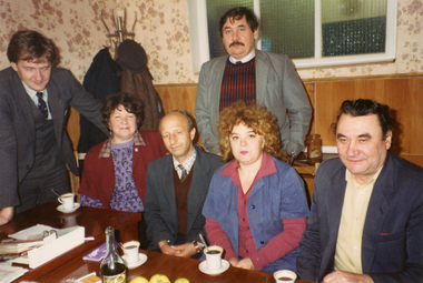
Program Photos ReviewSet Design, Liliom by Ferenec Molnar directed by Joy Youlden
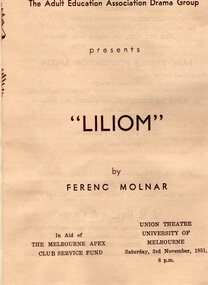
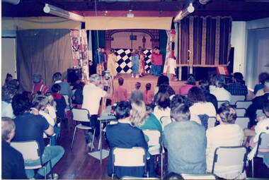
The Adult Education Association Drama Group originally staged Liliom at the Union Theatre, University of Melbourne on Saturday, 3rd November, 1951, at 8pm and on the 8th November it was re-staged by them as the opening production of the The City of Heidelberg Repertory Company, now known as the Heidelberg Theatre Company Inc. in the Eistedford Hall, Ivanhoe. Sketch for Prologue, Fair Ground Scene, and Sketch for Scenes 2 and 3, The Tin Type Shop, for Adult Education Association Drama Group production at the Union Theatre from 1st – 3rd November, 1951. Resulting sets were transported to the Eisteddfod Hall, Ivanhoe and used in the opening production in January, 1952 for the newly formed City of Heidelberg Theatre.Sketch for Prologue, Fair Ground Scene, and Sketch for Scenes 2 and 3, The Tin Type Shop, for Adult Education Association Drama Group production at the Union Theatre from 1st – 3rd November, 1951. Resulting sets were transported to the Eisteddfod Hall, Ivanhoe and used in the opening production in January, 1952 for the newly formed City of Heidelberg Theatre. Sketch for Prologue, Fair Ground Scene, and Sketch for Scenes 2 and 3, The Tin Type Shop, for Adult Education Association Drama Group production at the Union Theatre from 1st – 3rd November, 1951. Resulting sets were transported to the Eisteddfod Hall, Ivanhoe and used in the opening production in January, 1952 for the newly formed City of Heidelberg Theatre Company. Photo from unidentified newspaper of the director of Liliom by Ferenc Molnar, Joy Youlden.an Adult Education Association Drama Group production at the Union Theatre from 1st – 3rd November, 1951 and restaged at the Eisteddfod Hall, Ivanhoe as the opening production in January, 1952 for the newly formed City of Heidelberg Repertory Group. The Adult Education Association Drama Group performers, backstage workers and technicians staged the play at the Eisteddfod Hall in Ivanhoe. Local Councillor E.A. Carlyle attended and addressed the audience. Reg Rudd is described as director-producer. He announced another Repertory evening in February. Inagural production under the name of The City of Heidelberg Repertory Company, now known as the Heidelberg Theatre Company Inc., staged in the Eisteddfod Hall, 14 Ivanhoe Parade, Ivanhoe, Victoria, Australia on the 8th November, 1952.All items in good condition. Original and one colour photocopy of hand drawn sketches for the Prologue and Scenes 2 and 3 settings in blue biro with watercolour washes on ecru paper. On the back side of paper with scene sketch of Act 1. Photo – Joy Youlden - Small black and white cutting from unidentified newspaper on newsprint which has yellowed, Cutting has been glued onto ecru A4 paper sheet. Sketch for Scene 6, The Land Beyond, and Sketch for Scene 7, Julies House 16 Years later, an Adult Education Association Drama Group production at the Union Theatre from 1st – 3rd November, 1951. Resulting sets were transported to the Eisteddfod Hall, Ivanhoe and used in the opening production in January, 1952 for the newly formed City of Heidelberg Repertory Group. Sketches for Scene 4, The Railway Embankment, and Sketch for Scene 5, Behind The Shop, an Adult Education Association Drama Group production at the Union Theatre from 1st – 3rd November, 1951. Resulting sets were transported to the Eisteddfod Hall, Ivanhoe and used in the opening production in January, 1952 for the newly formed City of Heidelberg Repertory Group. Handwritten detail of scene numbers and names, name of producer, theatre company AEA (Adult Education Association) Drama Group Show and place, Union Theatre.eistdford hall, fern matthews, city of heidelberg repertory group, adult education association drama group, liliom, liliom by ferenec molnar directed by joy youlden, 1952, 1 -
 Sunbury Family History and Heritage Society Inc.
Photograph, School concert 1988, 1988
The photograph taken from the rear of the hall shows the seated audience watching a group of children performing on stage. The concert was organised by Bulla Primary School staff and students and the event took place in the Bulla Community Hall in Greene Street. A non-digital coloured photograph of a concert in a hall with a view of the event taken from the back of the hall.school concerts, bulla community centre., bulla primary school -
 Maldon Vintage Machinery Museum Inc
Pump - Centrifugal, Late 20th century
Single stage self priming pump. Part of housing cut away to show interior for display purposes. Grey painted with cross section edges painted black. Black knobs for removing inspection cover on front end.Nameplate on top "Primo Titan" 50mm. Thompsons Kelly and Lewis logo on end cover. -
 National Wool Museum
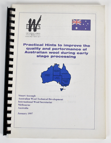
Booklet - Practical Hints to improve the quality and performance of Australian wool during early stage processing, Stuart Ascough, January 1997
Part of a collection of books, manuals, photographs, letters and clothing relating to the working life of Stuart Ascough. Stuart's career in the wool industry spanned over 43 years from 1960 to 2003 in various roles including Topmaking Plant Manager at Courtaulds Ltd. in Spennymore, U.K., Operations Manager at Port Phillip Mills in Williamstown Victoria, Marketing Executive, Early Stage Wool Processing at the International Wool Secretariat Melbourne, Australia and General Manager of Victoria Wool Processors Pty. Ltd. in Laverton North, Victoria. Throughout his career Stuart travelled extensively, and in the 1990s worked at many topmaking mills in China on quality improvement projects. He also provided technical advice and training at mills in India, Ukraine, Lithuania, Kyrgyzstan, Russia, Latvia, Byelorussia and other parts of Europe and Asia.Printed booklet bound with plastic black ring binder consisting of approximately 80 pages. Front cover shows graphic of Australian flag in top right corner and blue map of Australia, showing states and territories, in the centre.front: IWS / INTERNATIONAL / WOOL / SECRETARIAT / Practical Hints to improve the / quality and performance of / Australian wool during early / stage processing / Stuart Ascough / Australian Wool Technical Development / International Wool Secretariat / Melbourne / Australia / January 1997stuart ascough, international wool secretariat, victoria wool processors, port phillip mills pty ltd, topmaking, career, wool industry, training, technical advice, mills -
 National Wool Museum
Photograph - Chernihiv Worsted and Cloth Mill, Ukraine, 1990s
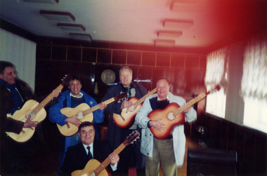
This image shows members of the International Wool Secretariat, including Stuart Ascough, at the Chernihiv Worsted and Cloth Mill in the Ukraine. Part of a collection of books, manuals, photographs, letters and clothing relating to the working life of Stuart Ascough. Stuart's career in the wool industry spanned over 43 years from 1960 to 2003 in various roles including Topmaking Plant Manager at Courtaulds Ltd. in Spennymore, U.K., Operations Manager at Port Phillip Mills in Williamstown Victoria, Marketing Executive, Early Stage Wool Processing at the International Wool Secretariat Melbourne, Australia and General Manager of Victoria Wool Processors Pty. Ltd. in Laverton North, Victoria. Throughout his career Stuart travelled extensively, and in the 1990s worked at many topmaking mills in China on quality improvement projects. He also provided technical advice and training at mills in India, Ukraine, Lithuania, Kyrgyzstan, Russia, Latvia, Byelorussia and other parts of Europe and Asia.Image depicting five men holding guitars in an indoor setting.stuart ascough, international wool secretariat, topmaking, career, wool industry, training, technical advice, mills, ukraine, textile industry, chernihov, guitars -
 National Wool Museum
Photograph - Chernihiv Worsted and Cloth Mill, Ukraine, 1990s
This image shows the team from the topmaking section at the Chernihiv Worsted and Cloth Mill in the Ukraine. Part of a collection of books, manuals, photographs, letters and clothing relating to the working life of Stuart Ascough. Stuart's career in the wool industry spanned over 43 years from 1960 to 2003 in various roles including Topmaking Plant Manager at Courtaulds Ltd. in Spennymore, U.K., Operations Manager at Port Phillip Mills in Williamstown Victoria, Marketing Executive, Early Stage Wool Processing at the International Wool Secretariat Melbourne, Australia and General Manager of Victoria Wool Processors Pty. Ltd. in Laverton North, Victoria. Throughout his career Stuart travelled extensively, and in the 1990s worked at many topmaking mills in China on quality improvement projects. He also provided technical advice and training at mills in India, Ukraine, Lithuania, Kyrgyzstan, Russia, Latvia, Byelorussia and other parts of Europe and Asia.Image depicting four men and two women seated and standing around a table with coffee cups.stuart ascough, international wool secretariat, topmaking, career, wool industry, training, technical advice, mills, ukraine, textile industry, chernihov -
 National Wool Museum
Photograph - International Wool Secretariat Team with Ukrainian Soldiers, Kyiv, Ukraine, 1990s
This image shows members of the International Wool Secretariat team, including Stuart Ascough, with Ukrainian soldiers in Kyiv, Ukraine. Part of a collection of books, manuals, photographs, letters and clothing relating to the working life of Stuart Ascough. Stuart's career in the wool industry spanned over 43 years from 1960 to 2003 in various roles including Topmaking Plant Manager at Courtaulds Ltd. in Spennymore, U.K., Operations Manager at Port Phillip Mills in Williamstown Victoria, Marketing Executive, Early Stage Wool Processing at the International Wool Secretariat Melbourne, Australia and General Manager of Victoria Wool Processors Pty. Ltd. in Laverton North, Victoria. Throughout his career Stuart travelled extensively, and in the 1990s worked at many topmaking mills in China on quality improvement projects. He also provided technical advice and training at mills in India, Ukraine, Lithuania, Kyrgyzstan, Russia, Latvia, Byelorussia and other parts of Europe and Asia.Image depicting a group of men, most in military uniform, standing in front of a white building with green lattice.stuart ascough, international wool secretariat, topmaking, career, wool industry, training, technical advice, mills, ukraine, textile industry, kyiv, soldiers -
 University of Melbourne, Burnley Campus Archives
Album - Digitised, Sandra Pullman, Sandi Pullman Album, 1998-2000
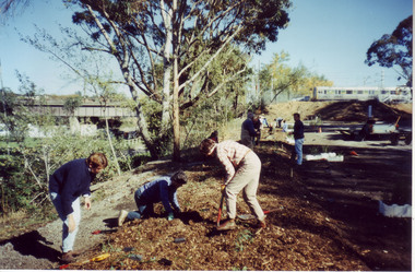
93 photographs from Sandi Pullman's album. Scanned March 2013. Some have descriptions on reverse. Originals remain with Sandi Pullman (Student, FOBG). (13-19) John Delpratt's Grassland Project FOBG 30.05.98. (20-30) FOBG Working Bee 10.10.98 Ground Cover Trial Plots. (1-12) First Friends of Burnley Gardens Working Bee, "Planting the Back Car Park along the trainline 2nd May, 1998. (First Stage of the car park sited on Richmond City Council land at the rear of the College completed 1980.) (31-45) Back Car Park 11.09.99. (46-51) Native Garden 27.11.99. (52-53,72-75) 150th Celebration of What? Oct 2000, Ellis Stones Rockery Oct 2000. (54-58, 71, 76, 84, 86, 88-91, 93) Harvesting Grasses. (59-62) Nicki Rose from the Australian Plant Society presenting Dr Greg Moore with $1,500 cheque at an afternoon tea on the Citriodora Lawn 31.03.2000. (63-70) Melbourne International Flower & Garden Show (M.I.F.G.S.) 2000. (77-83) First Pruning Day 1999.sandi pullman, sandra pullman, fobg, john delpratt's grassland, working bee, native garden, ellis stones rockery, harvesting grasses, nicki rose, australian plant society, dr greg moore, melbourne international flower & garden show, m.i.f.g.s., back car park, wrong 150th celebrations, ground cover trials -
 Wodonga & District Historical Society Inc
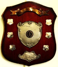
Award - Mann's of Wodonga Supreme Champion Led Horse Shield
In a "LED HORSE" category, the horse is presented bridled and unsaddled. The handler leads the horse in clockwise direction on the circle. The horse is required to walk and trot and stand to be judged. The judge looks for correct conformation of the horse as well as ahorse that is neatly presented and in good condition. Straight movement, correctness and quality of paces and obedience of the horse are also taken into consideration. This trophy was sponsored by Manns of Wodonga. The Mann family operated a major business in Wodonga for 85 years, beginning with a produce store in February 1921. It expanded to become one of Australia’s largest regional shopping centres, with a Supermarket, Hardware Store, Steel Store, Plumbing and Industrial supplies store, at one stage employing well over 100 people. The Mann Family sold the business in 2006.This item has local significance as it records winners in equestrian events at the Wodonga Show. The award was also presented by a prominent citizen of Wodonga.A wooden shield with metal plaques engraved with names and year of competition winners for the Supreme Champion Led horse at the Wodonga Show.On gold toned banner at top: "Manns of Wodonga" On bottom plate: Supreme Champion/ Led Horse of / the Wodonga Show" On smaller shields: "1976/MISS M McINTYRE/ GREEN VALLEY/CALYPSO", "1977 /MISS M McINTYRE/BIRRAHLEE LONICERA" , "1978/J. VINGE/ HILLINVIEW/BLACK PANTHER" , "1979/MRS A. WILKINSON/SWEET SUE"equestrian events wodonga show, wodonga show, supreme champion led horse, mann wodonga -
 Melbourne Legacy
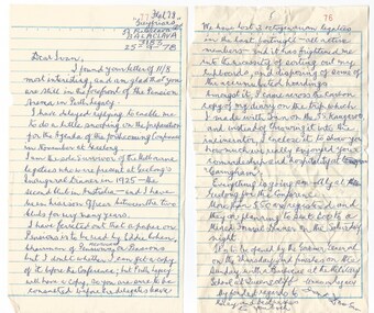
Letter - Document, letters, 1978
A letter dated 25 September 1978, that Legatee Frank Doolan wrote to a Perth Legatee before the 1978 Conference in Geelong. In the letter he mentions that he is trying to ascertain details about the Agenda for the forthcoming Conference in Geelong in November 1978. In particular that a Pensions paper that is to be presented by Eddie Cohen, Chairman of the Melbourne Pensions Committee. Frank mentions that he is the sole survivor of the dinner held for the Geelong Club's inauguration. He says that they have lost 3 octagenarian Legatees in the past fortnight and this has prompted Frank to clear out some of his papers. He also mentions a carbon copy of a diary he had kept on a trip to Perth on the SS Kangaroo and how he appreciated Ivan's hospitality and comradeship on that visit. (see item 01132). The 1978 Geelong Conference had more than 550 Legatees registered at that stage and were planning to seat 600 at a Formal Dinner on the Saturday night. The Conference was to be opened by the Governor General on Thursday and close with a barbeque at the Military School at Queenscliff on the Sunday. Was with other memorabilia that has come from Frank Doolan from both is war service and his time with Legacy.The letter shows the type of correspondence used in the 1970s between Legatees and that strong friendships were maintained between Legatees from different regions of Australia.A letter x 2 pages, written by Frank Doolan to Ivan Davies, a Perth Legatee.Letter is handwritten. In top right corner '77' and '78' is in red type from the notebook it was taken from.conference, frank doolan, comradeship -
 Melbourne Legacy
Document - Speech, Moments in the History of Legacy 1987 (H59), 1987
A copy of an address given at a Foundation Day Luncheon by a long standing Legatee and past President Legatee Rob Allison. He had joined Legacy in 1950, and he comments that only 5 members remain active that were with him in 1950. In 1950 they were all posted as member of various committees, he got Welfare and Friday night girls' classes. There were 9 boys' classes throughout Melbourne, and girls' twice a week at Legacy Headquarters at 24 Market St. There were 230 active members and each legatee had 4 or 5 families with children. He mentions that in 1950 the President was 62 years old but only 5 years after the end of the war, the tide had begun to turn towards the 39ers. (He called the older legatees '1914ers' or 'the Bow and Arrow boys'). He applauded the 'founding fathers' for limiting the numbers of members, in 1929 it was 230 and in 1959 a limit of 300. They used a classification method to classify the members so they had a diverse range of skills and community representation. Areas were: Production, Distribution, Services Public Authority, Services Other, and Board List. The President had a Secret Committee of 3, no one knew who was on the committee, even those members didn't know the identity of the other 2. This committee vetted the background and integrity of new members. In 1950 the budget was £27,000 plus a capital budget of £3,500. Legatee Allison tells a good story of his induction into Legacy, including his wife joining other Legatees wives in fundraising. In 1951 Comradeship meetings moved to Thursday nights at the instigation of Burt Nathan. 'Birthday boy' invitations started in 1958 when John Cooper was Chairman of the Comradeship. After some years of discussion the first paid Social Worker was employed in 1953 and as a result her efforts the first Senior Widows' Group got underway. Until the 1950s Legacy had always found the money it required, from big companies, wealthy members of the community, Estates, or Trusts. In 1951 it tried to copy a Sydney Legacy idea (Certificate of Adoption Plan) and called it 'The Endowment Scheme'. Other fundraisers included films, premiere showing and musicals were very much a part of the social life of Legatees. One premiere show in 1952, 'The Greatest Show on Earth' was sold at £100 a double. In 1959 Sir Frank and Lady Tait were kind enough for give us a premiere of 'My Fair Lady'. As the 50s progressed cash flow was not enough and it was decided in 1957 to have the first public appeal (he says 1957 but it was 1956). The first Badge day was 1958 (according to this account). He says it grossed £21,000 (net £17,000). And the Legacy story was becoming better known. 'Legacy has never been a one man band. The strength has been in the resourceful ability of those of its members.' He was well placed to tell the story of the donation towards Dureau House. BG Corporation in New York used 'Brown and Dureau' as agents in Melbourne for their spark plug manufacturing (for the American aircraft based in Australia during the war). A royalty of two shillings and sixpence was agreed. The entrepreneur President of BG Corporation was Richard Goldsmith. L/ Grat Grattan had a friend Mr Edwards who was managing director at Brown and Dureau and heard of the desire by Goldsmith to leave a permanent memorial to ex-servicemen in Australia (Children's Hospital was considered). Grat took Edwards to Market St and showed him the inadequacy of the building. It was agreed if Melbourne Legacy could come up with a purchased building in 10 days they would get the money needed. The property purchased was 'Storey Hall' in Swanston St (also called Hibernian Hall in other documents). After the war it turned out not to be suitable and a new building was required. The speaker is identified as Rob Allison based on two things; at one stage he refers to himself as 'Rob' and this copy of the speech has been faxed to Legacy from the offices of John Allison Monkhouse. Another copy of this address has been located with the date of September 1988 that was filed with information on Past Presidents and the lives prominent legatees. The notation H59 in black pen shows that it was part of the archive project that was trying to capture the history of Legacy. A record of Legatee Rob Allison speaking at a Legacy luncheon about significant events since he joined in 1950. Speakers at Legacy luncheons were from very different walks of life and the subjects spoken on were many and varied. Foundation Day was celebrated with a special luncheon.White A4 photocopy with black type x 8 pages of an address about Legacy history written in 1987.Handwritten H59 in black pen. history, speech, foundation day, past presidents, dureau house, rob allison -
 Melbourne Legacy
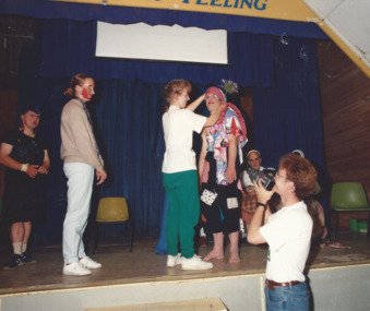
Photograph, HDC Camp 1992, 1992
... 1992. These photos show costumes and a stage production. Other.... These photos show costumes and a stage production. Other photos from ...Photos from a camp for handicapped dependents in January 1992. These photos show costumes and a stage production. Other photos from the camp are at 01560, 01562, 01563 and 01564. Some appeared in the newsletter in March 1992. The article mentions that the annual camps run for two weeks at Somers Camp (believed to be Somers School Camp). It is a wonderful gathering of Junior Legatees, Legatees, and dedicated helpers. 50 Legatees attended this camp with the personal attention almost one-to-one. With ages ranging from 22 to into the 60s, Legacy has to ensure it caters for the differing needs. Legatees headed by Camp Chief, Jim Hammon and Chairman of the Handicapped Dependents Committee, Merv Tickell, were supported by two Camp Co-Ordinators and 50 helpers known as 'leaders'. Many of the leaders are people in the workforce wishing to give something back to the community. Junior Legatees are organised into groups. They participate in horse-riding, swimming, golfing, strawberry picking, and many other activities. Every month Legacy's handicapped dependents are invited to go on outings or take part in recreational and educational activities. These programmes aim to develop independence and thus lessen the need for reliance on others for simple routine functions. Photos were in a scrapbook of photos spanning 1983 to 1991.A record of the type of activities Legacy provided for the handicapped dependents of the Legacy families. Colour photo x 3 of a HDC camp, a label and an article in the newsletter.Handwritten in blue pen 'HDC Camp -Somers / Jan 1992 / Camp Chief: L/ J Hammon / Co-ordinator Julien Hardy-Smith / Photo Eric Wadsworth / 51 J/Ls'junior legatee outing, hdc, somers camp -
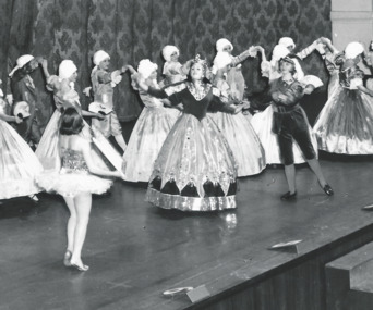 Melbourne Legacy
Photograph, Annual Demonstration
A photo of a junior legatees in elaborate ballgowns and old fashioned outfits, and wigs dancing on stage at the Annual Demonstration. Central characters appear to be a queen and a girl in a tutu as part of a dramatic dance routine. Legacy clubs ran classes for junior legatees for many years such as gymnastics, swimming or dancing classes. It was part of providing for the children of their deceased comrades. The skills they learned were show cased in an annual demonstration usually at the Melbourne Town Hall. It appears to be photo taken professionally of the Annual Demonstration. Year unknown.A record of a way Legacy provided classes for junior legatees and the skills learned were displayed in the Annual Demonstration.Black and white photo of junior legatees in ball gowns dancing on stage at Melbourne Town Hall.Stamped "Leslie Thomspon / 8 Keystone Cres / East Kew WL 3078" in purple ink. Handwritten 'Legacy P2' in blue pen.junior legatee, annual demonstration -
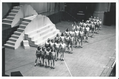 Melbourne Legacy
Photograph, Annual Demonstration
A photo of a large group of young junior legatees in sports outfits dancing on stage at the Annual Demonstration. Legacy clubs ran classes for junior legatees for many years such as gymnastics, swimming or dancing classes. It was part of providing for the children of their deceased comrades. The skills they learned were show cased in an annual demonstration usually at the Melbourne Town Hall. It appears to be photo taken professionally of the Annual Demonstration. Year unknown.A record of a way Legacy provided classes for junior legatees and the skills learned were displayed in the Annual Demonstration.Black and white photo of junior legatees in sports outfits dancing on stage at Melbourne Town Hall.Stamped "Compliments of the Ministry of Tourism / Government of Victoria / please acknowledge Michael Cheshire" in grey ink. Handwritten 'Legacy P2' in blue pen.junior legatee, annual demonstration -
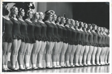 Melbourne Legacy
Photograph, Annual Demonstration
A photo of a large group of young junior legatees in dance outfits lined up on stage at the Annual Demonstration. Legacy clubs ran classes for junior legatees for many years such as gymnastics, swimming or dancing classes. It was part of providing for the children of their deceased comrades. The skills they learned were show cased in an annual demonstration usually at the Melbourne Town Hall. It appears to be photo taken professionally of the Annual Demonstration. Year unknown.A record of a way Legacy provided classes for junior legatees and the skills learned were displayed in the Annual Demonstration.Black and white photo of junior legatees in dance outfits lined up on stage at Melbourne Town Hall.Stamped "Compliments of the Ministry of Tourism / Government of Victoria / please acknowledge Michael Cheshire" in grey ink. Handwritten 'Legacy P2' in blue pen.junior legatee, annual demonstration