Showing 427 items
matching topography
-
 Lakes Entrance Historical Society
Book - Whisper Lake Tyers, Jack & Grace Whadcoat, 2017
An insight into the environment people and events at Lake Tyers Victoriasettlement, topography, environment -
 Lakes Entrance Historical Society
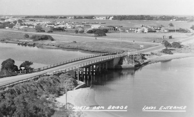
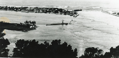
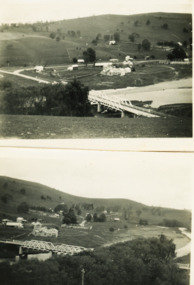
Photograph - North Arm bridge Lakes Entrance Victoria, Bulmer H D, 1945c
Notes: Club Hotel spit has not yet been formed. Also Postcard 8.5 x 13.5Black and white photograph of the North Arm Bridge, It shows the reinforced concrete bridge over the North Arm, and a rear view of other notable buildings. In the background sand hummocks. Lakes Entrance Victoriabridges, topography, township -
 Lakes Entrance Historical Society
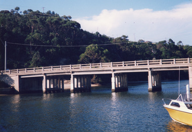
Photograph - North Arm bridge Lakes Entrance Victoria, Davies, Judy, 1999c
Colour photograph of the concrete bridge over the North Arm, taken from the western side, showing part of the northern embankment and four sets of piers. In the background wooded Kalimna Heights with some residences visible. Right foreground is the bow of a small runabout. Lakes Entrance Victoriabridges, boats and boating, topography -
 Lakes Entrance Historical Society
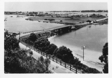
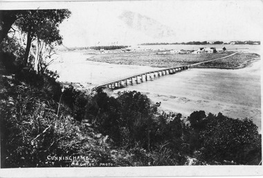
Postcard - Lakes Entrance from Jemmys Point, Bulmer, H D, 1940c
Also two black and white copies, One Colour tinted copyBlack and white photographic postcard of bridges over North Arm, showing town, electricity and telephone poles. Cunninghame Arm, sand hummocks, sand flat at entrance to town. Post and rail fence beside sealed highway. Lakes Entrance Victoriatownship, fences, topography -
Lakes Entrance Historical Society
Book, Gardner P D, Names of Bass Strait, 1996
Some of the place names of the Bass Strait coasts, and Bass Strait Islands, and explanations of their meanings. Illustrated with maps and photographs.township, social history, topography -
Lakes Entrance Historical Society
Book, LERHS, Background to Entrance Construction, 1989|2013
Containing background information about the planning construction and opening of the artificial entrance from the ocean to the Gippsland Lakes Victoriawaterways, civil engineering, topography -
 Lakes Entrance Historical Society
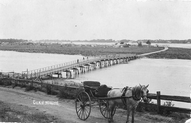
Postcard - North Arm bridge. Lakes Entrance Victoria c1900, Cooper Alexander, 1900c
CunninghameSepia coloured postcard of first bridge over North Arm, showing view of town buildings, including Club Hotel; sand hummocks; Cunninghame Arm; die back of melaleuca on sand flats. In foreground post and rail fence beside road, two wheeled horse drawn vehicle, jinker, with grey horse standing in shafts. Ten or eleven people standing on bridge. Lakes Entrance Victoriatopography, bridges, transport -
 Lakes Entrance Historical Society
Postcard - North Arm, Lakes Entrance Victoria c1898, 1898 c
Black and white postcard of wooden bridge across the North Arm, showing sand hummocks Cunninghame Arm, Club Hotel, and die back of melaleuca on mudflats, caused by salination of Lakes after artificial entrance opened 1889. Vegetation on Kalimna Hill in foreground. Steamer on Cunninghame Arm centre top of photo. Lakes Entrance VictoriaCunninghame N Cairebridges, topography, township -
 Lakes Entrance Historical Society
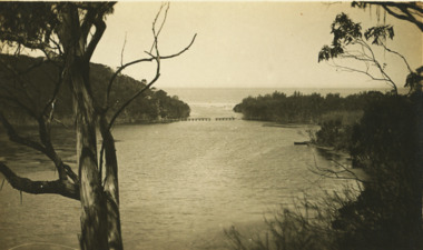
Postcard - Postcard/Cross Landing, 1910c
Paired with image 03733.1 for display at 150 years Lakes Entrance 1858 to 2008 held in October 2008Black and white postcard of lake foreshore at Cross Landing showing framework for drying fishing nets near shoreline jetties over water near steep shoreline in distance Lake Tyers Victoriaocean, topography, fishing industry -
 Lakes Entrance Historical Society
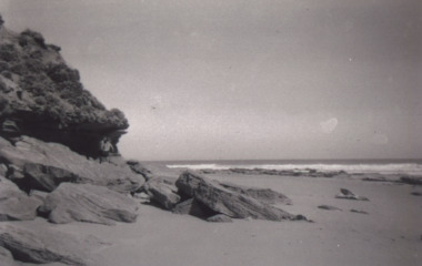
Photograph - Red Bluff, 1950 c
Also a colour photograph of western side of Red Bluff taken by Ian Fraser c 1990Black and white photograph showing west side of Red Bluff with sand built up over rocky beach, low vegetation on rocky bluff, two men in swimming trunks on rocks Lake Tyers Victoriatopography, people, clothing -
Lakes Entrance Historical Society
Book, Burt, Jocelyn, Discovering Gippsland, 1985
Photographs and text highlighting the natural beauty of Gippsland, Victoria.topography, township, parks -
Lakes Entrance Historical Society
Book, Conservation Analysis Report Fairy Dell, 2004
Research, interpretation and management recommendations for Fairy Dell Scenic Reserve, near Bruthen, East Gippsland, Victoria, by a Forestec studentnatural history, topography, parks -
 Lakes Entrance Historical Society
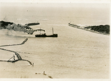
Postcard - SS Despatch, c1910
Second copy same viewSmall format postcard showing coastal steamer SS Despatch leaving Cunninghame Arm, with entrance piers and rock groynes in view. Lakes Entrance VictoriaThe Piers from the lookout at Jemmys Point (on back)jetties, topography, ships and shipping -
 Lakes Entrance Historical Society
Postcard - The Entrance, Valentine Series, The Entrance to the Gippsland Lakes, 1895c
Also a Black and white copy 11.5 x 18Colour tinted postcard of the entrance from Bass Strait to the Gippsland Lakes. It shows two small buildings on Bullock Island, groyne from Bullock Island across Cunninghame arm, sand inside entrance at western pier. Lakes Entrance VictoriaLakes Entrance from Jemmys Pointislands, topography, waterways -
Lakes Entrance Historical Society
Book, Hewitt Geoff Bader Hans Dieter, Geometria, 2007
Report on the geomagnetic archaeological survey of areas of prograded Ninety Mile Beach shore in East Gippsland Victoria, immediately to the East and West of the artificial entrance to the Gippsland Lakes.waterways, topography, ships and shipping -
 Lakes Entrance Historical Society
Postcard - Lake Bunga, W S Vogt Bairnsdale, 1925 c
Black and white postcard showing view of Lake Bunga remains of wooden bridge between tree covered banks Lake Bunga Victoriawaterways, tramway, topography -
 Lakes Entrance Historical Society
Postcard - Brodribb River Bridge, Sherwood, Orbost, 1907 c
Black and white postcard of the bridge over the Brodribb River near Orbost VictoriaBrodribb River 6.4.07waterways, bridges, topography -
 Lakes Entrance Historical Society
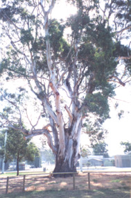
Photograph - Eucalyptus Tree, Mallacoota Victoria, 2005 c
Colour photograph of unique eucalyptus tree, eucalyptus globulus ssp pseudoglobulus eucalyptus cypella carpic. A rare localised distribution with aesthetic significance Mallacoota Victoria. Also a second colour photograph of same tree trees, topography, towns -
 Lakes Entrance Historical Society
Photograph - Mallacoota, Bulmer, 1950 c
Two other black and white photographs of Mallacoota Inlet taken further up the lake 05315.1 and 5315.2Black and white photograph of Mallacoota Inlet and islands. Home Range in backgroundwaterways, township, topography -
 Lakes Entrance Historical Society
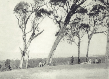
Photograph - Roadknights Merrangbaur property Lakes Entrance Victoria, J Brookes, 1889
Black and white photograph taken from Roadknights Merrangbaur property looking towards the natural entrance, seven people sitting or standing on brow of hill Lakes Entrance Victoria. Also a colour photograph taken from Merrangbaur hill of warm holes and dunes and ocean approximate site of original entrance taken in 1995 historic site, topography, ocean -
 Lakes Entrance Historical Society
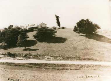
Photograph - Pine Hill Guesthouse, 1950c
Also second copy which is a very clear photo.Sepia toned photograph of Pine Hill Guesthouse, showing rambling building on top of hill, landmark tree, and pine trees on hillside. Road in foreground is Princes Highway. In far distance a glimpse of Cunninghame Arm. Lakes Entrance VictoriaPine Hill Lakes Entranceguesthouses, roads and streets, topography -
 Lakes Entrance Historical Society
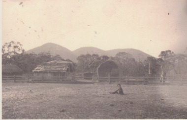
Photograph - Settlement, 1890
Sepia toned photograph of bark roofed farm building and hay stack behind three railed post and rail fence, sliprail gateway. Boy and dog seated in foreground. High peaks in distance known as The Brothers. East Gippsland Victoriahouses, topography, settlers -
 Lakes Entrance Historical Society
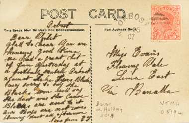
Postcard - Correspondence to Miss Evans at Lima East from Orbost, H D Bulmer, 1907 c
Letter on back to Miss Evans Lima East via BenallaCorrespondence on a postcard with view of Snowy River at Dickens Knob Victoriawaterways, topography, correspondence -
 Lakes Entrance Historical Society
Photograph - Buchan Victoria, Myrtle Olive Fish, 1/09/1933 12:00:00 AM
Black and white photographs of view of Buchan with bridge over Buchan River in foreground with butter factory behind and various buildings Buchan Victoriatopography, township, waterways -
 Lakes Entrance Historical Society
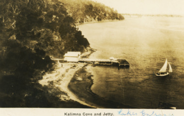
Postcard - Kalimna Cove, H D Bulmer, 1920 c
Black and white postcard of Kalimna Cove and jetty with sailboat on water taken from,high point at Kalimna VictoriaKalimna Cove and Jettywaterways, topography, boats -
 Lakes Entrance Historical Society
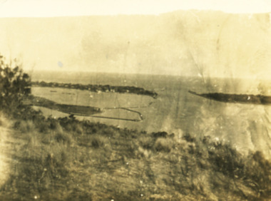
Photograph - View from Kalimna Lookout, 1/01/2025 12:00:00 AM
Sepia toned snapshot of view from Kalimna lookout over the entrance and end of Bullock Island Lakes Entrance Victoriawaterways, islands, topography -
 Lakes Entrance Historical Society
Postcard - Albert Park Lake Tyers, 1910c
Note on back to Miss Barber from Betty saying she asked Mrs Blay about accommodation etc. Also another postcard 03833.2 to a Clarence Pawsey dated 18.3.1918Sepia toned postcard showing Albert Park Guest House consisting of bedroom wing on left and detached kitchen dining wing on right, verandah across front of building with two deck chairs and bench on verandah, man and lady standing and lady sitting on bench. Extensive paths and garden in front, glimpses of other buildings at back. Two water tanks at left one round galvanized and one square, trees behind building. Lake Tyers VictoriaAlbert Park Lake Tyers Victoriawaterways, topography, guesthouses -
 Lakes Entrance Historical Society
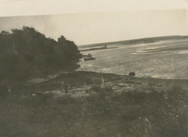
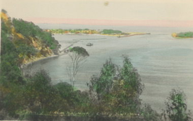
Postcard - New Works Lakes Entrance
view of the entrance at Lakes EntrancesizeColour tinted postcard showing view of the entrance at Lakes EntranceThe Entrance Lakes Entrance Victoriawaterways, topography, land settlement -
 Lakes Entrance Historical Society
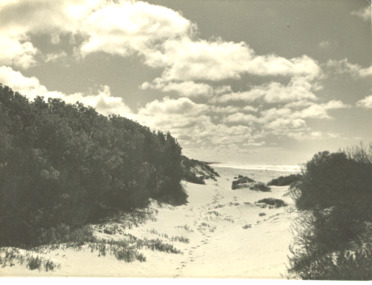
Photograph - Track at sand hummocks Lakes Entrance Victoria
track through vegetation and sand hummocks with distant ocean view. Part of western end of township across Cunninghame Arm in distance Lakes Entrance VictoriaBlack and white photograph showing track through vegetation and sand hummocks with distant ocean view. Part of western end of township across Cunninghame Arm in distance Lakes Entrance Victoriatopography, beach, ocean -
 Lakes Entrance Historical Society
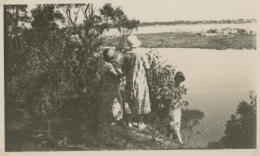
Photograph - View across North Arm to the rear of Club Hotel Lakes Entrance, 1920 c
Kalimna Heights looking across North Arm to the rear of Club Hotel, swampy terrain between hotel and North Arm Lakes Entrance VictoriaBlack and white photograph showing three women on Kalimna Heights looking across North Arm to the rear of Club Hotel, swampy terrain between hotel and North Arm Lakes Entrance Victoria jetties, waterways, topography