Showing 594 items matching " underground"
-
 Bendigo Historical Society Inc.
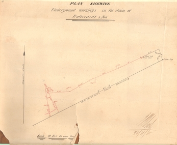
Document - MARKS COLLECTION: PLAN OF UNDERGROUND WORKING IN BALLERSTEDT & SON MINE, 28th November, 1965
Buff coloured document, heavy parchment, printed in black. On top of plan 'plan showing underground workings in the claim of Ballerstedt & Son.' Plan shows underground workings in red, with distances and angles. On bottom of drawing 'Ballerstedt's South Boundary'. Signed on bottom in black ink (indecipherable signature) and dated 28.11.65. Document attached is related to the donor Phillipa Marks' family and contains the recollections of her great grandfather in regard to Bendigo's Jewish community and synagogues.bendigo, mining, ballerstedt & son mine -
 Tatura Irrigation & Wartime Camps Museum
Photograph - copy, Dhurringile Mansion Stables, 1977
Copy of original. Photograph, one of many taken by J. Lowry, of managers residence and surrounds, Dhurringile Mansion.Copy of Black and white photograph of Dhurringile Mansion stable and office block.Dhurringile Mansion stables and office block, courtyard showing butchers block and dome of underground tank. Nth wing residence of Jack and Knowla Lowry 1938-1977.dhurringile mansion stables, dhurringile mansion butchers block, dhurringile mansion, knowla lowry, jack lowry -
 Bendigo Historical Society Inc.
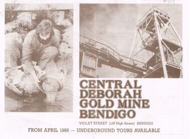
Book - CENTRAL DEBORAH GOLD MINE: ADVERTISEMENT FOR UNDERGROUND TOURS FROM APRIL 1986
Central Deborah Gold Mine - Advertisement for underground tours from April 1986 / A4 size paper folded in half with photos of gold panning and mine works ./ Chronological history of the mine.book, bendigo, central deborah gold mine -
 Bendigo Historical Society Inc.
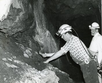
Photograph - AUSTIN COLLECTION: UNDERGROUND AT CENTRAL DEBORAH, RAY BEER
Black and white photo: two men wearing hard hats and lights inspecting ore samples underground. Ray Beer pictured on LH side of image, other man holding camera.mining, business, central deborah gold mine -
 Bendigo Historical Society Inc.
Slide - ALBERT RICHARDSON COLLECTION: BORING ON A REEF
Slide. Bendigo Mines-Jack Hattam Collection. Workers boring on a reef, underground at Catherine United Mine but could be New Moon. Image sourced from ' Healthy Golden Bendigo' book.No. 44 printed on bottom of slidemine, gold, catherine united, underground., bendigo mines-jack hattam collection. -
 Whitehorse Historical Society Inc.
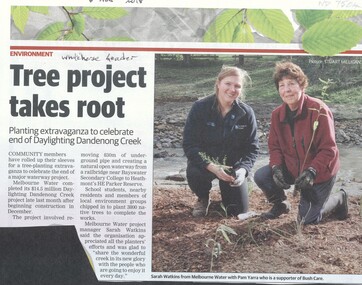
Article, Daylighting Dandenong Creek, 2018
Melbourne Water completed its $14.5 million Daylighting Dandenong Creek project which involved removing 830m of underground pipe.Melbourne Water completed its $14.5 million Daylighting Dandenong Creek project which involved removing 830m of underground pipe. Members of the local community engaged to tree planting the area.Melbourne Water completed its $14.5 million Daylighting Dandenong Creek project which involved removing 830m of underground pipe. melbourne water, bush care, heathmont, dandenong creek -
 Whitehorse Historical Society Inc.
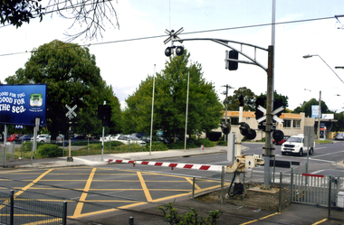
Photograph, Mitcham Railway Crossing, 2012
Coloured photograph of the railway line over Mitcham Road as of 2012. The boom gates are down and a white van is coming from the direction of Vermont. In 2013/14 the railway line was reconstructed underground.mitcham railway crossing, railway crossings -
 Bendigo Historical Society Inc.
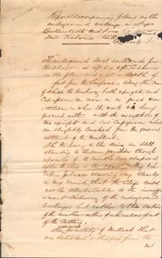
Document - MARKS COLLECTION: REPORT ACCOMPANYING PLAN ON THE BALLERSTEDT & SONS MINE, VICTORIA HILL
Handwritten two page document. On top of document: Report accompanying plan on the underground working in Messrs Ballerstedt & sons ( indecipherable word ) mine, Victoria Hill. This document refers to item 8300.bendigo, mining, ballerstedt & son mine -
 Bendigo Historical Society Inc.
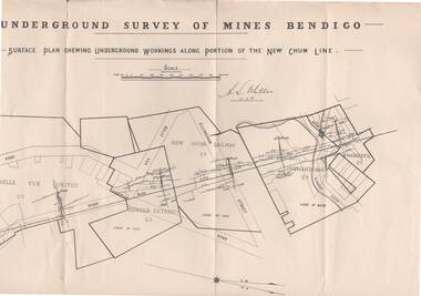
Map - STRUGNELL COLLECTION: NEW CHUM LINE, 25/5/01
Map, Surface Plan Showing underground workings along portion of the New Chum Line.South Belle Vue United, Eureka Extended, New Chum Railway, Shenandoah Co. Shamrock Co..A.S.Whitelawmap, bendigo, new chum line -
Lakes Entrance Historical Society
Book, Paill Raymond, Old Walhalla- Portrait of a Gold Town, 1964
A history of the town of Walhalla victoria, from the early alluvial mining in 1860's through the heady days of rich underground mining to its rgression to a sleepy ghost town in the 1960'smines and mining, township, transport -
 Bendigo Historical Society Inc.
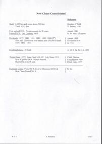
Document - NEW CHUM CONSOLIDATED MINE - NOTES ON THE NEW CHUM CONSOLIDATED MINE
Handwritten notes on the New Chum Consolidated Mine. Notes include depth of shaft and winze, first worked, formed, last crushing, dividends, crushing battery, poppet legs and underground conns.document, gold, new chum consolidated mine, new chum consolidated mine, notes on the new chum consolidated mine, bendigo goldfield g brown 1936, annals 1880, m d q & a reports, annals 1888, a m s sp ed 1/6/1899, caleb thomas long section new chum line 1857, m d -
 Eltham District Historical Society Inc
Negative - Photograph, J.A. McDonald, Henley Road at Watsons Creek, Apr. 1961
Henley Road at Watsons Creek showing excavation at western pier Rock at contract level, slight underground flow Early April 1961Record of various Shire of Eltham infrastructure works undertaken during the period of 1952-1962 involving bridge and road reconstruction projects, sometimes with Eltham Shire Council Project Reference numbers quoted. It was during this period that a number of significant improvements were made to roads and new bridges constructed within the shire that remain in place as of present day (2022). In many situations, the photos provide a tangible visible record of infrastructure that existed throughout the early days of the Shire. The album was put together by or under the direction of the Shire Engineer, J.A. McDonald.infrastructure, shire of eltham, bend of islands, cr. charis pelling, henley road, henley road bridge, kangaroo ground, oxley bridge, watsons creek, w.e. wolf, bridge construction, road construction, 1961-04 -
 Bendigo Historical Society Inc.
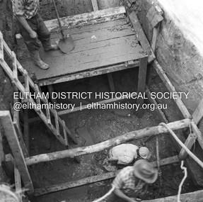
Photograph - Kangaroo Flat Gold Mine Collection: underground in Swan Decline, Kangaroo Flat Gold Mine, 2000
The modern mine is accessed via the Swan Decline, which commences at the Kangaroo Flat site on the southern outskirts of Bendigo and progresses in a north easterly direction between the Deborah and Sheepshead anticlines, reaching a depth of almost 1000 m below the City of Bendigo. Development of this decline commenced in 1998. Swan Decline closed and history preserved In a major rehabilitation milestone at Kangaroo Flat, the Swan Decline Bendigo’s primary gateway to underground mining, was permanently closed in December 2022. Important parts of Bendigo’s gold rush history were also preserved from the onsite office buildings with 19 boxes of records, and 1350 old photos being scanned and provided to the local historical societies and the Goldfields Library Corporation. A volunteer from the Bendigo Historical Society, Kay MacGregor, also scanned approximately 40 bookshelves of newspaper clippings to assist with recording and preserving geological drilling locations.Black and white photocopies of photographs of Swan Decline, showing some stages of underground construction. Eleven images on 3 pages, dated 16/4/2000 (10 a.m.) show decline walls, rock bolts and markout of tunnel shape. One image shows a utility in the tunnel. Final three images on one page, have notations on the photos: 'opposite SP18 LHS decline', 'just up from previous 3 box positions' and 'just up from tank, same side' On bottom RH side 'spots for scale attention, IT required, all lower decline.' All three images dated 12/6/2000.goldmining, kangaroo flat gold mine, western mining corporation, unity mining, swan decline -
 Bendigo Historical Society Inc.
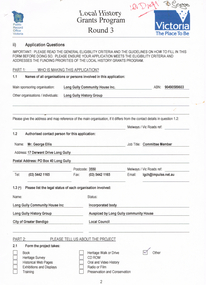
Document - LONG GULLY HISTORY GROUP COLLECTION: LOCAL HISTORY GRANTS PROGRAM ROUND 3
Application form to Local History Grants Program Round 3. Four pages with Public Record Office Victoria and logo in the top left corner and Victoria the Place To Be and logo in the top right corner. Written at the top of the page is ? Draft. Application is for a Poppet Head to acknowledge the Men and their families who worked in the underground mining industry and the achievement that Underground Mining made to make the City of Greater Bendigo what it is today. Also mentioned is estimated cost of of the project.bendigo, history, long gully history group, the long gully history group - local history grants program round 3, public record office victoria, long gully community house inc, long gully history group, mr george ellis, city of greater bendigo, long gully linear park, city of greater bendigo recreation department, city of greater bendigo community environmental education department, long gully community newsletter, eaglehawk times, bendigo advertiser, bendigo tourist bureau, shared action project (st lukes) -
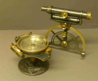 Federation University Historical Collection
Instrument - Miner's Dial, c early 1900s
A miner's dial was used by surveyors to determine the direction of underground tunnels and roadways. The inclinometer allowed measurement of the angles at which mine tunnels descend into the ground.A rare miner's dial in a hinged timber box.This surveying instrument consists of a theodolite monsblr on a magnetic compass, which sits on the vertical tapered spigot of a base plate. Fits tripod catalogued item 4133. Inside the box lid is the supplier's label - W. Travill (successor to D. Esdale) of 146 Little Collins Street, Melbournemining, ballarat school of mines, surverying, scientific instruments, scientific objects -
Hume City Civic Collection
Photograph, Rupertswood Gardens
The gardens in the photograph were designed by William Sangster. When they were first constructed a tennis court, croqued lawns and an underground fernery were included in the landscape.A non-digital black and white photograph with a cream border of a long winding pathway in a garden setting. gardens, trees, salesian college, rupertswood battery, sir william john clarke, lady janet clarke -
Bendigo Historical Society Inc.
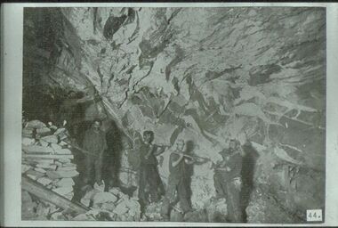
Document - Digital, KEN BICE COLLECTION: STOPES ON CATHERINE REEF
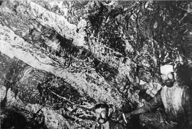
Copy of photo: written on back stopes on the Catherine Reef, spurs, Catherine Reef United Mine, Eaglehawk, 1905. Image shows four men underground with picks, working in a stope. This is a digital only photograph.bendigo, mining, catherine reef, catherine reef, bendigo, stopes, miners, mining -
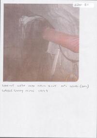 Bendigo Historical Society Inc.
Photograph - KEN BICE COLLECTION: WATTLE GULLY GOLD MINE
Colour photograph, faded and laminated. Image shows underground tunnel with air line on RH side. On bottom of image:' looking west into main xcut No. 1 level (60m) Wattle Gully Mine 1979.'mining, underground equipment, wattle gully gold mine -
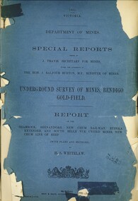 Bendigo Historical Society Inc.
Book - UNDERGROUND SURVEY OF MINES, BENDIGO GOLDFIELD 1901, 1901
UNDERGROUND SURVEY OF MINES, BENDIGO GOLDFIELD 1901. Report on the Shamrock, Shenandoah, New Chum Railway, Eureka Extended, and South Belle Vue United Mines, New Chum Line of Reef. With plans and sections.H.S. Whitelawbendigo, hospital, gold mining, bendigo, goldfields, gold mining, shamrock, shenandoah, new chum railway, eureka extended, and south belle vue united mines, new chum line of reef. -
Tatura Irrigation & Wartime Camps Museum
Photograph - copy, Dhurringile Mansion Stables, 1977
Copy of original photograph, Courtyard of stables, store rooms, pay office for original Dhurringile Mansion.Black and white photograph of Mr J. Lowry in courtyard of old stables built in 1902 with red gum chopping block, the dome of the underground tank which was 20 feet deep and 18 feet in diameter.jack lowry, dhurringile stables -
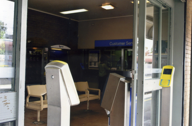 Whitehorse Historical Society Inc.
Photograph, Mitcham Railway Station
Coloured photograph of the ticket office on the north side of Mitcham railway station in 2012. The white object to the left is the ticket machine. Reconstruction of the Mitcham station in 2013 saw the railway line and station moved underground.mitcham railway station, railways -
 Whitehorse Historical Society Inc.
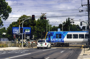
Photograph, Mitcham Railway Crossing
Coloured photograph of a Metro train crossing Mitcham Road and heading east towards Ringwood - 2012. In 2013, due to the amount of traffic using Mitcham Road, the railway line and station were reconstructed underground.mitcham railway crossing, trains, railways, transport -
 Whitehorse Historical Society Inc.
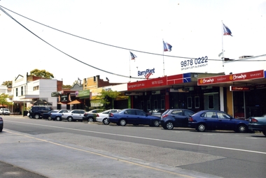
Photograph, Blackburn Shopping Centre, 2012
Coloured photograph of the shops on the southern side of South Parade, Blackburn. Barry Plant Real Estate prominent -2012. on the other side of South Parade is a bus stop and the underground entrance to the Blackburn Station platforms.shops, blackburn shopping centre, south parade, blackburn -
 Bendigo Historical Society Inc.
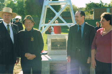
Photograph - LONG GULLY HISTORY GROUP COLLECTION: THE BENDIGO UNDERGROUND MINER MONUMENT
BHS CollectionColour photo of George Ellis, Daryl McClure, another man and a lady standing in front of the Bendigo Underground Miner Monument. The monument has a poppet leg standing on a stone base with two plaques on the side.bendigo, history, long gully history group, the long gully history group - the bendigo underground miner monument, george ellis, daryl mcclure -
 Greensborough Historical Society
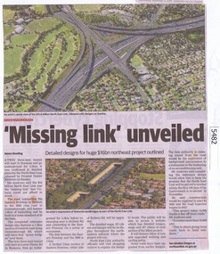
Newspaper Clipping, Diamond Valley Leader, 'Missing Link' unveiled, 12/09/2018
A twin three lane tunnel will start in Rosanna and go underground for 5.3km, it was confirmed in detailed plans for the North East Link released by Premier Daniel Andrews on Sunday.News article 1 page, black text and colour image .north east link, daniel andrews, rosanna -
 Stawell Historical Society Inc
Photograph, "Magdala-Cum-Moonlight" Mine at the 1100 ft level on visible gold looking South 1895
Face in Stopes at 1.100ft level on visible gold looking south Underground Magdala-Cum-Moonlight Mine 1895. The mine ceased production after World War 1.stawell mining -
 Greensborough Historical Society
Newsletter - Leaflet, North East Link Authority, North East Link tunnels, and, Community Updates March 2022, 2022
The North East Link Authority was set up to lead development of this project. This newsletter, and additional leaflets, are to keep the community informed of project designs and developments in the area of underground tunnels.An ongoing collection of community updatesVarious page leaflets, colour text and images. Multiple updates on tunnels.north east link, metropolitan ring road, north east link tunnels -
 Bendigo Historical Society Inc.
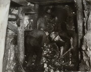
Photograph - UNDERGROUND MINE
Black and white photograph of underground mine working with two workers shovelling rock in foreground, another miner working in upper background. Mine drive (end) showing wooden support posts and associated timber work.mining, underground equipment, miners, bendigo, mines and mining, mines, miners -
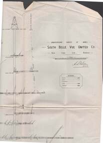 Bendigo Historical Society Inc.
Map - STRUGNELL COLLECTION: UNDERGROUND SURVEY OF MINES, BENDIGO, 29-3-01
Map, Underground Survey of Mines, Bendigo, South Belle Vue United Co.,New Chum Line.Transverse Section. Signed H.S.Whitelaw29.3.01 Drawing appears to show samples of connecting horizontal shafts with their respective mineral contentsH.S.Whitelawmap, bendigo, south belle vue united co.. -
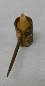 Bendigo Historical Society Inc.
Tool - MINING 'SPIDER' CANDLE HOLDER
Metal candle holder, cylindrical, open top and bottom, with metal spike attached. Used by underground miners. Candle holder was stuck into timbers or rock to provide light. Small stub of candle in holder. Wick fraying.gold mines, mining equipment, candle holder