Showing 8271 items
matching 1965-1966
-
 University of Melbourne, Burnley Campus Archives
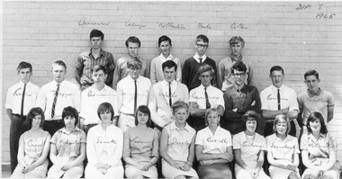
Photograph - Black and white print, Dept of Agriculture, Victoria, Dip I 1965 Student Group, 1965
Black and white photograph of students standing and seated in front of a brick wall. These students graduated with a Diploma of Horticulture in 1968. Names written in ink on students' pictures and, "Dip I 1965."students, diploma of horticulture, 1968, student group -
 Ringwood and District Historical Society
Folder, Ringwood Primary School: Photos of Teachers and classes with names 1965-1969, 1969
Hand made folder of photos.Ringwood Primary School 1965 - 1969.; Photos of teachers and classes with names. -
 NMIT (Northern Melbourne Institute of TAFE)
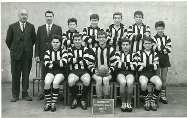
Photograph: Collingwood Technical School 1965 Soccer team
Black and white photo of Collingwood Technical School 1965 Soccer team.collingwood technical school, students, teams, nmit -
 Greensborough Historical Society
Document - Constitution, Greensborough Football Club Constitution 1965, 10/11/1965
1965 amended version of the Constitution of the Greensborough Football Club. Date of amendment 10/11/1965.Outlines the 'objects' of the club and rules relating to the running of the Greensborough Football Club.Grey paper cover. 5 pages.greensborough football club, constitution -
Federation University Historical Collection
Photograph - Black and White, Ballarat Courier Photographer, Girls School Fair - 1965, 1965
Adults and students posed for professional photographOn back written in pen:: "Oct 13th 1965 Girls School Fair" Stamp for BALLARAT COURIER - Press Photographballarat girls school, fair, 1965, ballarat girls' technical school -
 Rutherglen Historical Society
Document - School Records - Register, J.J. Gourley, Government Printer, Pupils' Register. State Primary School. School No. 522, Rutherglen. 1962 - 1965, 1962-1965
Handwritten pupil register. Cover printed with the title "Pupils' Register. State Primary School. School No." followed by a space for the school number and name to be written in. The remainder of this cover contains printed directions to aid the entry of information about pupil enrollments.Written in ink on top right of the cover: "3518-3667" Written in pencil below the name of the school: "1962-1965"teacher records, rutherglen, state primary school, pupils, students, school reports, rutherglen state primary school no 522 -
City of Moorabbin Historical Society (Operating the Box Cottage Museum)
Newsletter, City of Moorabbin Historical Society No.1 Vol. 6 February 1966, City of Moorabbin Historical Society Newsletter No.1 Vol. 6 February 1966, 1966
This is Newsletter No 1 Vol .6 produced in February 1966 by Mr T. A. Sheehy CMHS for members and visitors Topic; Chelteham Arts & Crafts, East Bentleigh State School Register The Aims of the CMHS are ‘to record the history of the City, and register something of the Australian Atmosphere, which the necessary speed-up in post-world-war two (WW11) immigration has caused to be lost; to produce a magazine at regular intervals, featuring the work of pioneers and the changing Australian scene; to work constantly with a long range view towards building a hall where records and exhibits can be housed’ (1961) The Original Newsletters reflect the history and heritage of the former City of Moorabbin — derived from Mooroobin, ‘a resting place’ in the Bunurrung spoken language. In 1994, the City of Moorabbin was integrated into the Cities of Bayside, Glen Eira, Kingston and Monash. This is Newsletter No. 1 Vol. 6 of the CMHS in February 1966 CMHS obtained a Kingston City Council Community Grant 2016 for the digitization and preservation of these Original CMHS Newsletters commenced in 1961 2 x L 26cm x W 21cm page 1 printed both sides CITY OF MOORABBIN HISTORICAL SOCIETY / AFFILIATED WITH THE ROYAL HISTORICAL SOCIETY OF / VICTORIA AND THE CHELTENHAM ARTS AND CRAFTS SOCIETY/ President Mrs N. Blackman….Editor of Newsletter Mr T.A.Sheehy Secretary Mrs F.Neville / VOLUME 6 No.1 NEWSLETTER FEBRUARY 1966city of moorabbin historical society 1961, sheehy t.a., newsletters, -
 Eltham District Historical Society Inc
Photograph, Fitzsimons Lane Bridge over Yarra River between Eltham and Templestowe, c.1966, 1966c
The bridge over the Yarra River was initially opened September 22nd, 1961. Newspaper reports at the time of opening stated it linked Bolton Street, Eltham, with Fitzsimons Lane, Templestowe. In 1955 the Country Roads Board (CRB) produced survey plans that showed proposed land acquisition for the future bridge and road approaches. The 1955 plan shows that it was proposed to connect Fitzsimons Lane with Bolton Street in Eltham by a diagonal road across the river. The road connection would then continue along Bolton Street to Main Road. Prior to construction of the bridge the CRB modified the proposal significantly so that there was a new road parallel with Bolton Street and then curving to join Main Road at what was then its intersection with Old Eltham Road. This involved significantly more land acquisition and altered the pattern of land subdivision through this corridor. Initially the new road was just a single two-way carriageway as it would have required a significant widening of the cutting on the Shire of Eltham side of the river. The road was officially un-named but was known locally as the Eltham-Templestowe Road. The 1966 Melway street directory and other 1960s editions also listed the road as the Eltham-Templestowe Road. In December 1970, Eltham Shire Council, in pursuance of the provisions of the Local Government Act, named it Templestowe Road. The road was renamed Fitzsimons Lane around 1984 in conformity with the section south of the river. In 1991 a new bridge was built to the west of the original bridge. Fitzsimons Lane was widened to four traffic lanes although on the Eltham side this was done within the limits of the existing cutting. NEW BRIDGE STARTS THEM EXPLORING Without any fanfares, Country Roads Board workmen on Friday afternoon put the finishing touches to the approaches, removed the barricades, and let the traffic roll over the new Yarra bridge linking Bolton Street, Eltham, with Fitzsimons Lane, Templestowe. Over the week-end many “bridge watchers” who were making one of their periodic inspections of the progress on the new bridge found to their surprise that they could drive over it, so that people who had gone for a run out to Eltham suddenly found themselves wandering through Templestowe and Doncaster. By Monday the word of the bridge’s opening had got around sufficiently for many regular travellers to the city from Eltham and beyond to vary the monotony by going to town via Templestowe and Kew instead of through Heidelberg. They were surprised at the distances – about 3 ½ miles from Eltham to Templestowe, 6 miles from Eltham Shire hall to the Lower Heidelberg Road-Banksia Street intersection. NEW NEIGHBOURS For people on both sides of the river, the new bridge has turned distant friends into near neighbours. A Greensborough man on Sunday took 35 minutes to reach the home of a friend in East Doncaster, but the return trip over the new bridge took only 17 minutes. It will be some time yet before most people work out the possibilities in shorter and quicker trips form the north-eastern areas to the eastern and south-eastern suburbs. The coming of the warmer months will soon teach many, though the short cuts to Peninsular beaches and eastern suburban drive-ins. And before very long it is likely there will be a Tramways bus running from Templestowe to Eltham station. NEW BRIDGE STARTS THEM EXPLORING (1961, September 27). The Diamond Valley News (News clipping held in SEA_74-1_047) The previously un-named road between Main Road and Yarra River, Eltham South, east of Bolton Street was named Templestowe Road, December 15, 1970 NAMING OF STREETS AND ROADS. (1970, December 15). The Diamond Valley News (News clipping held in SEA_74-2_022)Black and white photographManufacturer's marks: Polaroid, Batch #J62K181 (Sep 1966).infrastructure, shire of eltham infrastructure, bridge, fitzsimons lane bridge, polaroid, yarra river -
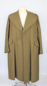 Montmorency–Eltham RSL Sub Branch
Uniform - Great Coat, 1966 Great Coat, 1966
Possibly Vietnam issueLong woollen coat, khaki in colour, buttons in front loose, size 5, internal collar labelInternal collar label says 8405-66 012-0493 DUNLOP N.S.W. 1966 Size 5trench, vietnam, great coat, khaki -
Whitehorse Historical Society Inc.
Document, Nunawading Arts Festival 1966, 1966
Entertainment guide to the third annual Nunawading Arts Festival 30th Sep - 22nd Oct 1966.Entertainment guide to the third annual Nunawading Arts Festival 30th Sep - 22nd Oct 1966. Includes Mitcham Repertory Group program for 'Fool's Paradise'. With tickets for three productions.Entertainment guide to the third annual Nunawading Arts Festival 30th Sep - 22nd Oct 1966. nunawading arts festival, repertory -
National Vietnam Veterans Museum (NVVM)
Photograph, Photograph taken during the Vietnam War 1966-67
Audio, CD OF PHOTOS TAKEN 1966-67 IN VIETNAM WITH 17 CONSTRUCTION SQD + 2 BW A4 SIZE PHOTOS OF MARCH BEFORE DEPARTING SYDNEY, THESE PHOTOS USED IN SYDNEY NEWSPAPERS 1966 -
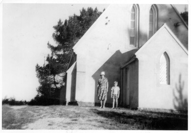 Linton and District Historical Society Inc
Photograph, Woman and child outside St Paul's Church of England, Linton, 1965
Black and white photograph of a lady wearing knee length dress and hat, with young boy wearing shorts and shirt, standing outside a church building."Ross and Grandma 1965 Linton Church of England".st paul's church of england linton -
 Murrumbeena Cricket Club
Headwear - Cap, Murrumbeena Cricket Club Premiership Cap 1st XI 1966-67
Murrumbeena Cricket Club 1st XI premiership cap 1966-67 belonging to Jeff Graham. Cap is ‘English’ style of cotton/wool material in maroon with the club logo, ‘Premiers 1966-67’ in gold.murrumbeena, murrumbeena cricket club, cricket, cricket clubs, clothing, cap, jeff graham -
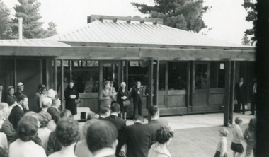 Ringwood and District Historical Society
Photograph of the Opening of Pinemont Kindergarten, Photograph of the Opening of Pinemont Kindergarten on 16th April 1966, 1966
Photograph of the Opening of Pinemont Kindergarten, with the Secretary, Mrs Perry, speaking to the audience in front of the kindergarten. The image is a little blurry. The Mayor of Ringwood is behind Mrs Perry. Dated 16th April 1966. -
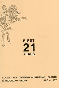 Ringwood and District Historical Society
Booklet, "First 21 Years"- Society for Growing Australia Plants, Maroondah Group 1966-1987, 1966-1987
Spiral bound booklet of 77 pages titled "First 21 Years" Society for Growing Australia Plants, Maroondah Group 1966-1987. Introduction by Paul Kennedy, President at the time of printing. -
 Ringwood and District Historical Society
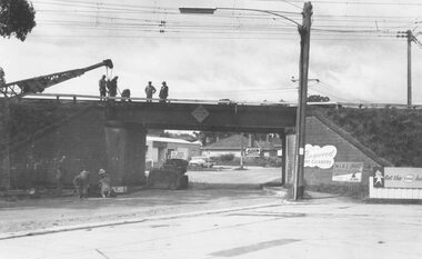
Photograph, Maroondah Highway West, Ringwood, 1965. Wantirna Road bridge
Written on rear of backing sheet: "Start of widening Wantirna Road bridge, 1965. -
 Ringwood and District Historical Society
Photograph, Maroondah Highway West, Ringwood, 1965. Wantirna Road bridge
Typed below photograph, "Wantirna Road railway bridge. Widening underpass - 1965". -
Stawell Historical Society Inc
Photograph, Stawell Technical School -- Form 2 B 1965
Stawell Technical School Class Photograph Form 2A March 10 1965Names on Backeducation -
 Bendigo Military Museum
Booklet - Operational Mapping and Surveys - South Vietnam 1966/67, Royal Australian Survey Corps
Report written for the "Australian?" Army Journal. This report describes in some detail the Australian 1st Topographical Survey Troop from its initial formation in Oct 1965 through its deployment to South Vietnam in May 1966 and its Operational activities during 1966/67 in support of the 1st Australian Task Force.A4 booklet, stapled in top left corner. "SSgt Learmonth" written on front cover.royal australian survey corps, rasvy, fortuna, army survey regiment, army svy regt, asr, 1st topographical survey troop, south vietnam -
 Ringwood and District Historical Society
Book List, Ringwood Historical Research Group, Ringwood Historical Research Group - List of Books 1966, 1966
List of books from various areas including Croydon, the Dandenongs, Ringwood and other areas by well known historical authors1 Foolscap page of the list of books belonging to Ringwood Hist Research Group in 1966 +Additional Keywords: McGivern, Muriel / Palmer, Nettie / Madden family (Ringwood) / Blainey, geoffrey / Bates, Weston -
Ringwood and District Historical Society
Envelope, Packet: Holeproof Ringwood 1948 and McRobertson's 1966 - Openings
Holeproof factory opening in Ringwood 1948; McRobertsons factory opening in Ringwood 1966 -
 Bendigo Military Museum
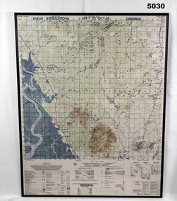
Map - MAP, MOUNTED, US Army 1966, Map information as of 1965
Map - colour map titled "XA BINH BA, VIETNAM" Scale 1:50,000. Map depicts "ENEMY INSTALLATIONS 1 APR - 22 OCT 68, CONFIDENTIAL" Map mounted on sheet of timber, sealed with a clear varnish.mapping, vietnam war -
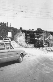
 Ringwood and District Historical Society
Photograph, Maroondah Highway West, Ringwood, 1965. Wantirna Road bridge
Written on back of photograph, "Wantirna Road railway bridge. Preparing to widen underpass - 1965". -
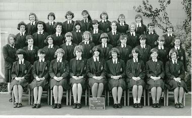 NMIT (Northern Melbourne Institute of TAFE)
Photograph: Preston Technical College 1965 Form Captains
Black and white photograph of Preston Technical College (Girls School) Form Captains of 1965preston technical college, preston girls technical school, students, form captains, nmit -
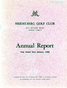 Heidelberg Golf Club
Booklet - Annual Report, Heidelberg Golf Club, Heidelberg Golf Club, Lower Plenty: Annual report, Year ended January 31st, 1965, 12/03/1965
Annual report of the Heidelberg Golf Club. Includes annual report, balance sheet and accounts to 31/01/1965. Annual General Meeting held 12/03/1965.Annual reports found in this collection begin in 1933-34.24 page document. Typed text and black and white photographs. Bound in red card cover annual reports, financial reports -
 Federation University Historical Collection
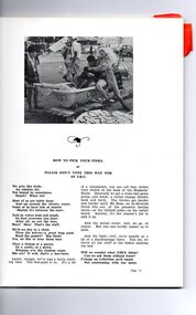
Magazine - Booklet, Ballarat School of Mines Students' Magazine, 1965, 1965
Ballarat School of Mines Students' Magazine, 1965 Let Stalk Strine, Principal's Page, Diplomas Conferred 1965, Prizes Presented, Ne Pas Classique, "Camping Daze", "The Civilising Influences of Mining", Jigging in Beds, The Srurrile, Man's Neurotic Flaw, Philosophy of Games, The Sporting Pages, School Council, Members of Staff, Roll Call 1965White soft cover with black drawings on front cover, 92 pages including advertisements.ballarat school of mines students' magazine 1965, staff, sports, trevor barnett, gary bunn, roger donaldson, fred evans, ralph fenney, greg hunter, jon mcdonald, malcolm park, geoff pollard, gary roberts, peter smith, john thorne, ian weybury, ratnam nachiappan, michael chung, wayne johnson, e. j. barker, thessalie hannah, noel hooper, david bell, shane carroll, peter thomas johnson, joseph leung chi kin, ronald charles miller, noel william nugent, poh teck chye, robert james strickland, john richard davis, william ralph clarke, gordon alexander johnson, leo gerard rawlings, kevin anthony sculley, garry james titheridge, daniel yung kwan yiu, robert stephen coutts, noel keith hart, michael hutchison, anne veronica moorhouse, douglas alan monro, william robert netherway, antoinette christina walta, david martin pollard, bernard bryan, john edward kavanagh, robert george sampson, pun vun tat, john william jolly, suresh chand, kevin thomas brady, r. h. pyke, helen herde, nick wolff, hencer spocking, john costa, c. n. antonio, j. f. hollioake, j. f. sullivan, k. j. delany, g. w. mcinnes, g. s. hunter, ting pang chew, b. j. keeble, richard chong, ng see yong, goh men tien, r. g. elshaug, b. r. wilson, j. dow, p. donaldson, g. mang, k. kelly, j. gudgeon, j. iredake, c. singleton -
 Stawell Historical Society Inc
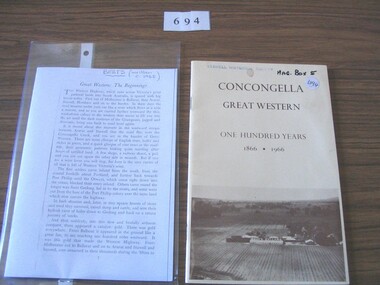
Book, Thompson Family, Concongella Great Western One Hundred Years 1866 – 1966, 1965
Pale Yellow card cover with picture of a vineyard on lower thirdCocongella Great Western One Hundred Years 1866. 1966 Inside: F H Thompson E V Thompsonstawell winery