Showing 730 items
matching aerial photos
-
 Port Melbourne Historical & Preservation Society
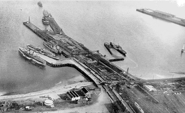
Photograph - Aerial view during construction of Station Pier, Port Melbourne, c. 1925
... Aerial photo showing the double-headed pier created... and Wharves - Railway Pier PS Weeroona PS Hygeia Aerial photo showing ...Aerial photo showing the double-headed pier created by partially dismantled Railway Pier and partially built Station Pier, late 1920s. Also the new wing piers with paddlesteamers Hygeia, Weeroona and Ozone (latter being broken up), foreshore and railyards, and end of Princes Pier. Pasted on A4 paper printed with computer generated chequered border.transport - shipping, piers and wharves - station pier, piers and wharves - railway pier, ps weeroona, ps hygeia -
 Port Melbourne Historical & Preservation Society
Photograph - Aerial view of J Kitchen & Sons site, Port Melbourne, 21 Mar 1939
... Large black and white aerial photo in narrow gold-coloured... aerial photo in narrow gold-coloured metal frame of J Kitchen ...Large black and white aerial photo in narrow gold-coloured metal frame of J Kitchen & Sons Pty Ltd factory with Woodruff St in foreground (Electric candles, pure Velvet Soap,and full company name on buildings) "Aerial view looking East. This view shows the two main blocks . 21/3/39" - printed below photo (copy of original)industry - manufacturing, built environment - industrial, j kitchen & sons pty ltd, pental products pty ltd, symex holdings ltd -
Bendigo Historical Society Inc.
Booklet - Up the Creek and Back Again, 2014
... and recovery. Edited by Carlene Dowie. Aerial photo of flooded township... and recovery. Edited by Carlene Dowie. Aerial photo of flooded township ...BHS CollectionSoft cover booklet of 96 pages titled 'Up the Creek and Back Again'. The remarkable story of Carisbrook's 2011 floods and recovery. Edited by Carlene Dowie. Aerial photo of flooded township on front and back covers. Illustrated with colour photos of people and events. First published by Carisbrook Disaster Recovery Committee Inc 2014. Printed by McPherson Printing Group, Maryborough, Victoria'M&J Qualtrough' sticker on first page carisbrook, floods -
 Falls Creek Historical Society
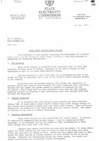
Document - SEC Information related to Tourist Hotel Project
... Plan & Aerial Photo of the proposed site was enclosed.... Recommended prior to application. A general Plan & Aerial Photo ...Bob (Herman) Hymans (a former member of the Royal Netherlands Navy) was born in Bloemendaal, Holland on 30th September 1922. During World War II he fought against the Japanese in the Dutch East Indies (now Indonesia) and was imprisoned in Changi and on the Burma Railway. After gaining qualifications as a Ski Instructor, Bob arrived in Falls Creek in July 1950. Working as an Instructor and Supervisor at Bogong Lodge, Bob decided his future was in accommodation. He was successful in negotiating an indenture for land from the State Electricity Commission (SEC). It took Bob two years to build his Grand Coeur Chalet but, tragically, it was burned down in August 1961. Bob also built the first Chairlift in Australia. This was a single chairlift and the structure was built from wooden electricity poles. He was constantly full of new ideas and proposals for the village. Bob Hymans died on 7th July 2007. This Collection of documents and letters tells the story of Bob's endeavours to develop Falls Creek into the ski village it is today.This item is significant because it documents proposals put forward by Bob Hymans to develop facilities in the Falls Creek Tourist Area.A letter from the SEC to Mr Hymans outlining information related to the Falls Creek Tourist Hotel Project. Topics covered include: Tourist Potential; Existing Development in the area; information regarding the Site For Development; Liquor Licence; Lease; Process for submission of applications & Designs; References Required; Inspection Recommended prior to application. A general Plan & Aerial Photo of the proposed site was enclosed.falls creek tourist area management committee, falls creek administration, sewerage system falls creek -
![Booklet: Bundoora: a site for Preston Institute of Technology [1968]](/media/collectors/4fac93a2023fd71f703efeec/items/519c5b782162ef13f0d2bf7b/item-media/519c5e5d2162ef13f0d2c4bd/item-fit-380x285.jpg) NMIT (Northern Melbourne Institute of TAFE)
NMIT (Northern Melbourne Institute of TAFE)Booklet: Bundoora: a site for Preston Institute of Technology [1968]
... . It is undated but probably late 1960s. Also a loose aerial photo.... It is undated but probably late 1960s. Also a loose aerial photo ...Booklet of 15 pages. On cover 'Bundoora: a site for Preston Institute of Technology'. Page 14 refers to this being a deputation from Preston City Council and Council of PIT to Victorian Premier applying for use of Bundoora Police Paddock for PIT. It is undated but probably late 1960s. Also a loose aerial photo of a site which is a closeup of a section of the photo on the cover of the booklet and this photo is dated 1968 preston institute of technology, preston technical college, bundoora campus, nmit -
 Melbourne Legacy
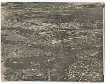
Photograph - Photo, Aerial view of the Somme
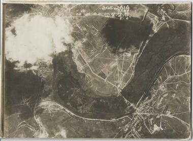
... An aerial photo of the Somme Swamp in France during World... An aerial photo of the Somme Swamp in France during World War One ...An aerial photo of the Somme Swamp in France during World War One. There are coordinates or numbers in some areas. Was with 11 other photos of World War One that had been mounted on board for display at Legacy House at some stage. When they were taken off display they were put in the archive cabinets. The founding legatees all served in World War One so these photos would have been of significant places for them. (see 01888 to 01899)Photos from World War One that would have been significant to the founding legatees.Sepia photo of the Somme battlefield in France during World War One.world war one, france, somme -
 Whitehorse Historical Society Inc.
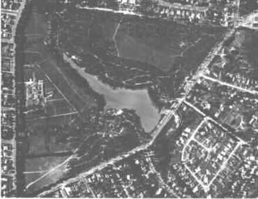
Photograph - Aerial Photograph, Aerial View of Blackburn Lake, C.1960s
... Black and white photo of Aerial View of Blackburn Lake.... and white photo of Aerial View of Blackburn Lake. Aerial View ...Black and white photo of Aerial View of Blackburn Lake.aerial photographs, blackburn lake -
 Bendigo Historical Society Inc.
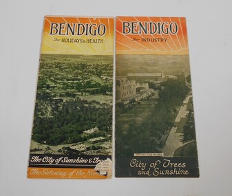
Pamphlet - Two small pamphlets. One titled Bendigo for holidays and health, the other Bendigo for industry
... . Under a black and white aerial photo of Pall Mall... a black and white aerial photo of Pall Mall with the soldier's ...Advertising material promoting the City of BendigoOne pamphlet as at the top Bendigo for industry, Bendigo the northern capital of Victoria, with a drawing of a rising sun. Under a black and white aerial photo of Pall Mall with the soldier's memorial in the foreground and the words: City of trees and sunshine, distributing centre to the golden north at the bottom. The other Bendigo for holidays and health, Bendigo the northern capital of Victoria. An aerial view of the City and the words The city of sunshine and trees, the gateway of the north.advertising, bendigo -
Kew Historical Society Inc
Plan - Pointed Firs Estate, Camberwell North, 1936
... as aerial photos and street views. The estate included lots... it, as well as aerial photos and street views. The estate included ...Subdivision plans and real estate flyers/brochures reveal a number of aspects of urban development and history. The Kew Historical Society's collection of these plans, as well as advertisements extracted from magazines, cover key aspects of community development and architectural history of Kew and Kew Eat as well as surrounding suburbs. While most of the plans in the collection were gifted to the Society by the former City of Kew, a number of other plans and advertisements have been donated by individuals, of which this is an example.Original multi-page sales brochure of the Pointed Firs Estate, advertised as located in Camberwell North, but now in Balwyn North. The 4-page bifold brochure includes promotional material as well as a detailed plan of the 28 lots for sale, a photograph of the locality with the plan overlaying it, as well as aerial photos and street views. The estate included lots in Doncaster Road, Thackeray Street, Houghton Street, an dMaud Street. pointed firs estate -- balwyn north, subdivisions -- balwyn north (vic.) -
 Melbourne Tram Museum
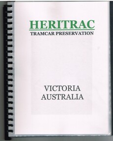
Book, Chris Treganowan, "Heritrac Tramcar Preservation Victoria Australia", c2002
... , an aerial photo of their storage shed near Seymour, including a list... a photograph of each of their trams, an aerial photo of their storage ...Plastic Presentation folder - ring bound - 24 plastic sheets each with an A4 insert titled "Heritrac Tramcar Preservation Victoria Australia" giving details of the group headed by Chris Treganowan who had collected a number of ex Melbourne tramcars and their tramcar collection, their activities and their planning c2002. Has a photograph of each of their trams, an aerial photo of their storage shed near Seymour, including a list of requested trams.trams, tramways, melbourne, mmtb, museum, tramcars, heritrac -
 Eltham District Historical Society Inc
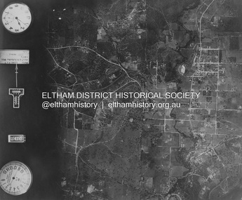
Photograph - Aerial Photograph, Landata, Eltham and Montmorency, Nov. 1931
... Aerial Photo... Historic Aerial Imagery Source: Landata.vic.gov.au Aerial Photo... Historic Aerial Imagery Source: Landata.vic.gov.au Aerial Photo ...Centred over present-day Belmont Reserve, Montmorency Historic Aerial Imagery Source: Landata.vic.gov.au Aerial Photo Details: Project No :1931 Project : MALDON PRISON Run : 19 Frame : 3130 Date : 11/1931 Film Type : B/W Camera : F8 Flying Height : 11000 Scale : 18860 Film Number : 60 GDA2020 : 37°43'13"S, 145°07'54"E MGA2020 : 335330, 5823576 (55) Melways : 21 F6 (ed. 42)aerial photo, eltham, neil webster collection, belmont reserve, montmorency, rattray road -
 Eltham District Historical Society Inc
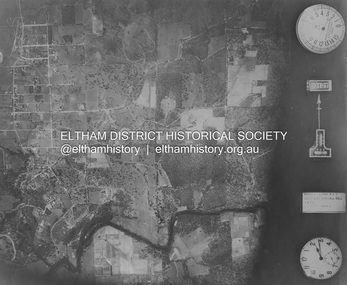
Photograph - Aerial Photograph, Landata, Eltham, Nov. 1931
... Aerial Photo... Aerial Photo Details: Project No :1931 Project : MALDON PRISON... Aerial Photo Details: Project No :1931 Project : MALDON PRISON ...Centred over Mount Pleasant Road and Kent Hughes Road, Eltham Historic Aerial Imagery Source: Landata.vic.gov.au Aerial Photo Details: Project No :1931 Project : MALDON PRISON Run : 20 Frame : 3137 Date : 11/1931 Film Type : B/W Camera : F8 Flying Height : 11000 Scale : 18860 Film Number : 60 GDA2020 : 37°43'37"S, 145°09'26"E MGA2020 : 337606, 5822892 (55) Melways : 22 A8 (ed. 42) aerial photo, eltham, neil webster collection, kent hughes road, mount pleasant road -
 Melbourne Legacy
Photograph - Photo, Aerial view of the Somme
... An aerial photo of the Somme in France during World War One... An aerial photo of the Somme in France during World War One ...An aerial photo of the Somme in France during World War One. There are coordinates or numbers in some areas. Also labelled is Bray. Was with 11 other photos of World War One that had been mounted on board for display at Legacy House at some stage. When they were taken off display they were put in the archive cabinets. The founding legatees all served in World War One so these photos would have been of significant places for them. (see 01888 to 01899)Photos from World War One that would have been significant to the founding legatees.Sepia photo of the Somme battlefield in France during World War One.world war one, france, somme -
Bialik College
Mixed media (Item) - Shakespeare Grove building 2005
... These images are an aerial shot, photo, and two sketches, created... These images are an aerial shot, photo, and two sketches, created ...Shakespeare Grove was the former site of Bialik College These images are an aerial shot, photo, and two sketches, created in 2005. Please contact [email protected] to request access to this record. Shakespeare Grove buildingbialik, 2000, 2005, buildings, heritage -
University of Melbourne, Burnley Campus Archives
Plan, Maplist: Catalogue of Victorian maps, 1984
... : Geographic, Geological Planimetric, Aerial Photography, Photo Maps..... Includes: Geographic, Geological Planimetric, Aerial Photography ...Brochure showing all standard series mapping in Victoria available from Map Sales Centre as at October 1984. Includes: Geographic, Geological Planimetric, Aerial Photography, Photo Maps.maps, catalogue -
 Eltham District Historical Society Inc
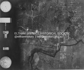
Photograph - Aerial Photograph, Landata, Eltham and Lower Plenty, Nov. 1931
... Aerial Photo... Aerial Photo Details: Project No :1931 Project : MALDON PRISON... Aerial Photo Details: Project No :1931 Project : MALDON PRISON ...Centred over present-day Rosehill Road and View Road, Lower Plenty Historic Aerial Imagery Source: Landata.vic.gov.au Aerial Photo Details: Project No :1931 Project : MALDON PRISON Run : 19 Frame : 3129 Date : 11/1931 Film Type : B/W Camera : F8 Flying Height : 11000 Scale : 18860 Film Number : 60 GDA2020 : 37°44'16"S, 145°07'40"E MGA2020 : 335039, 5821622 (55) Melways : 21 E11 (ed. 42)aerial photo, eltham, lower plenty, neil webster collection, rosehill road, view road -
 Eltham District Historical Society Inc
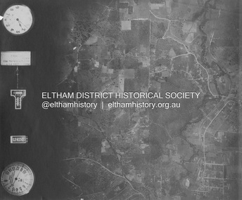
Photograph - Aerial Photograph, Landata, Eltham and Eltham North, Nov. 1931
... Aerial Photo... Aerial Photo Details: Project No :1931 Project : MALDON PRISON... Aerial Photo Details: Project No :1931 Project : MALDON PRISON ...Centred over present-day Opal Court and Manning Road, Eltham North Historic Aerial Imagery Source: Landata.vic.gov.au Aerial Photo Details: Project No :1931 Project : MALDON PRISON Run : 19 Frame : 3131 Date : 11/1931 Film Type : B/W Camera : F8 Flying Height : 11000 Scale : 18860 Film Number : 60 GDA2020 : 37°42'10"S, 145°08'07"E MGA2020 : 335621, 5825531 (55) Melways : 21 G2 (ed. 42)aerial photo, eltham, neil webster collection, eltham north, manning road, opal court -
 Eltham District Historical Society Inc
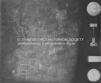
Photograph - Aerial Photograph, Landata, Eltham and Eltham East, Nov. 1931
... Aerial Photo...: Landata.vic.gov.au Aerial Photo Details: Project No :1931 Project : MALDON...: Landata.vic.gov.au Aerial Photo Details: Project No :1931 Project : MALDON ...Centred over present-day Beard Street bewteen Park Road and Main Road, Eltham East Historic Aerial Imagery Source: Landata.vic.gov.au Aerial Photo Details: Project No :1931 Project : MALDON PRISON Run : 20 Frame : 3135 Date : 11/1931 Film Type : B/W Camera : F8 Flying Height : 11000 Scale : 18860 Film Number : 60 GDA2020 : 37°42'16"S, 145°09'41"E MGA2020 : 337912, 5825386 (55) Melways : 22 B2 (ed. 42)aerial photo, eltham, neil webster collection, beard street, eltham east, main road, park road -
 Eltham District Historical Society Inc
Photograph - Aerial Photograph, Landata, Eltham, Nov. 1931
... Aerial Photo...: Landata.vic.gov.au Aerial Photo Details: Project No :1931 Project : MALDON...: Landata.vic.gov.au Aerial Photo Details: Project No :1931 Project : MALDON ...Centred over present-day Laleham Court between Arthur Street and Hartland Way, Eltham Historic Aerial Imagery Source: Landata.vic.gov.au Aerial Photo Details: Project No :1931 Project : MALDON PRISON Run : 20 Frame : 3136 Date : 11/1931 Film Type : B/W Camera : F8 Flying Height : 11000 Scale : 18860 Film Number : 60 GDA2020 : 37°42'56"S, 145°09'33"E MGA2020 : 337759, 5824139 (55) Melways : 22 B5 (ed. 42) aerial photo, eltham, neil webster collection, arthur street, hartland way, laleham court -
 Whitehorse Historical Society Inc.
Photograph, Nunawading Council Chambers
... Coloured photo of Aerial view of Nunawading Council... chambers nunawading library Coloured photo of Aerial view ...Coloured photo of Aerial view of Nunawading Council Chambers and librarymunicipal chambers, city of nunawading. council chambers, nunawading library -
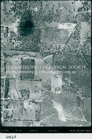 Eltham District Historical Society Inc
Photograph - Aerial Photograph, Landata, Eltham, Luck St; Bible St to Beard St, Dec. 1945
... Aerial Photo... Source: Landata.vic.gov.au Aerial Photo Details: Project No :5... Source: Landata.vic.gov.au Aerial Photo Details: Project No :5 ...Centred on present day Eltham East Primary School, east of Main Rd along Luck St to Beard St Historic Aerial Imagery Source: Landata.vic.gov.au Aerial Photo Details: Project No :5 Project : MELBOURNE AND METROPOLITAN AREA PROJECT Run : 36 Frame : 60548 Date : 12/1945 Film Type : B/W Camera : EAG4 Flying Height : 10200 Scale : 6000 Film Number : 195 GDA2020 : 37°42'46"S, 145°09'18"E MGA2020 : 337371, 5824456 (55) Melways : 22 A4 (ed. 42)aerial photo, eltham, arthur street, beard street, bible street, eltham east primary school, frank street, henry street, luck street, stanley avenue, wycliffe crescent, neil webster collection -
 Eltham District Historical Society Inc
Photograph - Aerial Photograph, Landata, Eltham, Main Rd; Railway Rd to Zig Zag Rd, Dec. 1945
... Aerial Photo... Aerial Photo Details: Project No :5 Project : MELBOURNE... Aerial Photo Details: Project No :5 Project : MELBOURNE ...Centred on present day Edendale Farm from Glen Park rd to Zig Zag Rd Historic Aerial Imagery Source: Landata.vic.gov.au Aerial Photo Details: Project No :5 Project : MELBOURNE AND METROPOLITAN AREA PROJECT Run : 37 Frame : 60549 Date : 12/1945 Film Type : B/W Camera : EAG4 Flying Height : 10200 Scale : 6000 Film Number : 196 GDA2020 : 37°42'12"S, 145°09'09"E MGA2020 : 337141, 5825486 (55) Melways : 21 K2 (ed. 42)aerial photo, eltham, edendale farm, eltham - yarra glen road, eltham-hurstbridge railway line, gastons homestead, gastons road, glen park road, main road, park road, railway road, wattletree road, zig zag road, neil webster collection -
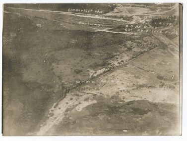 Melbourne Legacy
Photograph - Photo, Aerial view of the Somme
... An aerial photo of the Somme Swamp in France during World... An aerial photo of the Somme Swamp in France during World War One ...An aerial photo of the Somme Swamp in France during World War One. There are coordinates or numbers in some areas. Also labelled are the railway line and Canal du Nor and Limberlost Wood. Was with 11 other photos of World War One that had been mounted on board for display at Legacy House at some stage. When they were taken off display they were put in the archive cabinets. The founding legatees all served in World War One so these photos would have been of significant places for them. (see 01888 to 01899)Photos from World War One that would have been significant to the founding legatees.Sepia photo of the Somme battlefield in France during World War One.world war one, france, somme -
Stawell Historical Society Inc
Archive - Handbook, Aunde Employee Induction Handbook, 18/12/2003
... Plastic Cover over book. Black Card cover. B/W. Photo... Plastic Cover over book. Black Card cover. B/W. Photo aerial view ...Plastic Cover over book. Black Card cover. B/W. Photo aerial view Aunde BuildingsAunde Australia Oty Ltd. Employee Induction Handbook -
 Whitehorse Historical Society Inc.
Photograph, Aerial View of Site for Nunawading Civic Centre, 12/06/1968 12:00:00 AM
... Black and white photo of Aerial View of Site for Nunawading... Mitcham melbourne nunawading civic centre Black and white photo ...Black and white photo of Aerial View of Site for Nunawading Civic Centre.nunawading civic centre -
 Eltham District Historical Society Inc
Photograph - Aerial Photograph, Landata, Research, Vic, Apr. 1963
... Aerial Photo... Imagery Source: Landata.vic.gov.au Aerial Photo Details: Project... Imagery Source: Landata.vic.gov.au Aerial Photo Details: Project ...Centred on present day Marconi Court, Research bounded by Maroondah Aqueduct to north, Thompson Crescent to south, Joselyn Drive to east and Eltham Research Oval to west. Historic Aerial Imagery Source: Landata.vic.gov.au Aerial Photo Details: Project No :486 Project : MELBOURNE (1963) PROJECT Run : 5 Frame : 62 Date : 04/1963 Film Type : B/W Camera : RC8 Flying Height : 5100 Scale : 9600 Film Number : 1805 GDA2020 : 37°42'24"S, 145°10'43"E MGA2020 : 339434, 5825157 (55) Melways : 22 F3 (ed. 42)aerial photo, neil webster collection, 1963-04, joselyn drive, marconi court, melway 22f3, research (vic.), research oval, thompson crescent -
 Eltham District Historical Society Inc
Photograph - Aerial Photograph, Landata, Research, Vic, Apr. 1972
... Aerial Photo...: Landata.vic.gov.au Aerial Photo Details: Project No :985 Project : MELBOURNE...: Landata.vic.gov.au Aerial Photo Details: Project No :985 Project : MELBOURNE ...Centred on present day Maroong Drive, Research bounded by Allendale Road to north, Thompson Crescent to south, Eltham College to east and Parsons Road to west. Historic Aerial Imagery Source: Landata.vic.gov.au Aerial Photo Details: Project No :985 Project : MELBOURNE 1972 Run : 26 Frame : 193 Date : 04/1972 Film Type : B/W Camera : RC10 Flying Height : 5700 Scale : 9600 Film Number : 2636 GDA2020 : 37°42'04"S, 145°10'33"E MGA2020 : 339187, 5825794 (55) Melways : 22 F1 (ed. 42)aerial photo, neil webster collection, 1972-04, allendale road, eltham, eltham barrel, eltham college, maroong drive, melway 22f1, parsons road, research (vic.), thompson crescent -
 Eltham District Historical Society Inc
Photograph - Aerial Photograph, Landata, Eltham, Vic, Apr. 1972
... Aerial Photo... Imagery Source: Landata.vic.gov.au Aerial Photo Details: Project... Imagery Source: Landata.vic.gov.au Aerial Photo Details: Project ...Centred on present day Ryans Road at Sandra Avenue, Eltham bounded by Progress Road to north, Brougham Street to south, Bible Street to east and Outlook Crescent to west. Historic Aerial Imagery Source: Landata.vic.gov.au Aerial Photo Details: Project No :985 Project : MELBOURNE 1972 Run : 27 Frame : 48 Date : 04/1972 Film Type : B/W Camera : RC10 Flying Height : 5700 Scale : 9600 Film Number : 2636 GDA2020 : 37°42'41"S, 145°08'38"E MGA2020 : 336392, 5824574 (55) Melways : 21 H4 (ed. 42)aerial photo, neil webster collection, 1972-04, eltham, bible street, brougham steet, melway 21h4, outlook crescent, progress road, ryans road, sandra avenue, montmorency -
 Eltham District Historical Society Inc
Photograph - Aerial Photograph, Landata, Montmorency, Vic, Apr. 1972
... Aerial Photo... Imagery Source: Landata.vic.gov.au Aerial Photo Details: Project... Imagery Source: Landata.vic.gov.au Aerial Photo Details: Project ...Centred on present day Olympic Avenue at Grand Boulevard, Montmorency bounded by Meruka Drive to north, Main Road to south, Main Road to east and Alban Street to west. Historic Aerial Imagery Source: Landata.vic.gov.au Aerial Photo Details: Project No :985 Project : MELBOURNE 1972 Run : 28 Frame : 206 Date : 04/1972 Film Type : B/W Camera : RC10 Flying Height : 5700 Scale : 9600 Film Number : 2635 GDA2020 : 37°43'21"S, 145°07'46"E MGA2020 : 335154, 5823329 (55) Melways : 21 E7 (ed. 42)aerial photo, neil webster collection, 1972-04, eltham, alban street, grand boulevard, lower plenty, main road, melway 21e7, meruka drive, montmorency, olympic avenue -
 Eltham District Historical Society Inc
Photograph - Aerial Photograph, Landata, Eltham, Vic, Apr. 1972
... Aerial Photo... Imagery Source: Landata.vic.gov.au Aerial Photo Details: Project... Imagery Source: Landata.vic.gov.au Aerial Photo Details: Project ...Centred on present day Mays Road at Stringybark Road, Eltham bounded by Nyora Road to north, Yarra River to south, Reynolds Road to east and Bible Street to west. Historic Aerial Imagery Source: Landata.vic.gov.au Aerial Photo Details: Project No :985 Project : MELBOURNE 1972 Run : 28 Frame : 209 Date : 04/1972 Film Type : B/W Camera : RC10 Flying Height : 5700 Scale : 9600 Film Number : 2635 GDA2020 : 37°43'33"S, 145°09'28"E MGA2020 : 337647, 5823013 (55) Melways : 22 B8 (ed. 42)aerial photo, neil webster collection, 1972-04, eltham, bible street, mays road, melway 22b8, nyora road, reynolds road, stringybark road, yarra river