Showing 2558 items
matching aerials
-
 Stawell Historical Society Inc
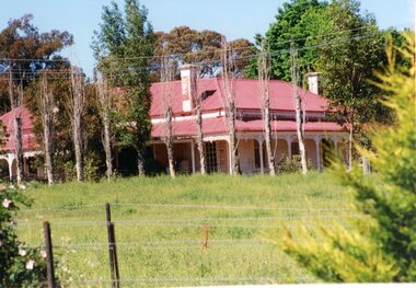
Photograph, “MORAY” Residence on Crowlands Road Stawell
Residence - “MORAY” Crowlands Road Stawell3 photos 1 black and white 2 colour of house Moray on Landsborugh Rd Stawell-2 Moray Stawell 1985. Aerial View.stawell -
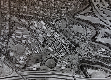
 Ringwood and District Historical Society
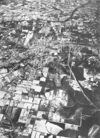
Photograph, Aerial view of Park Orchards and Ringwood - c.1960
Catalogue card reads, "Aerial view of Ringwood". -
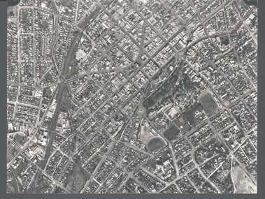
 Ringwood and District Historical Society
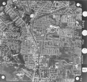
Photograph, Aerial photograph of Ringwood - 1962
Aerial photographWritten on backing sheet, 'Ringwood 1962'. -
 Running Rabbits Military Museum operated by the Upwey Belgrave RSL Sub Branch
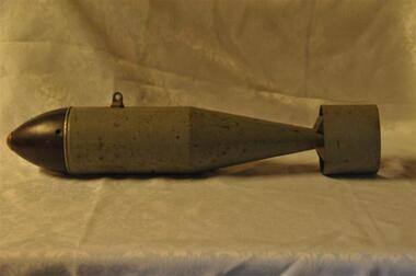
Bomb Aerial
Aerial Bombammunition, c1960, raaf -
 Creswick Campus Historical Collection - University of Melbourne
Still Image, 1964
Subject: Lower Glenelg Plantation . 7 brown envelopes marked Run 1. No. 12 - 17of 9 prints each. Stored in a brown cardboard file box marked Lower Glenelg Plantation Run No.1. 11 - 17(x9). Photos commissioned by Forests Commission Victoria 1964.Aerial Photographs -
Creswick Campus Historical Collection - University of Melbourne
Still Image, 1962
Subject: Kuark- McKenzie Crk Project . 5 brown envelopes marked Run 1A - Run 5 of 10 prints each. Stored in a brown cardboard file box marked Kuark- McKenzie Crk Project. Photos commissioned by Forests Commission Victoria 1962.Aerial Photographs -
Creswick Campus Historical Collection - University of Melbourne
Still Image, 1966
Subject: Creswick . 9 brown envelopes marked Run 6. containing c 80 marked up photos. Numbers 30 to 50, 88 - 91 in sequence. Stored in a brown cardboard file box . Photos marked on rear as on loan from the Photographic Library of theForests Commission Victoria . pencilled in date "1946?" on one envelope.Aerial Photographs -
Creswick Campus Historical Collection - University of Melbourne
Still Image, 1962
Subject: Ballarat-Creswick Plantations Block A . 4 brown envelopes marked Run 4 No. 135 - 138 of c.30 prints total. Marked up with red pen. Stored in a brown cardboard file box marked Errinundra Project..Combien Project...Ballarat Plantation. commissioned by Forests Commission Victoria 1962.Aerial Photographs -
Creswick Campus Historical Collection - University of Melbourne
Still Image, 1958 -1967
Subject: Calder Ridge Project . 3 brown envelopes marked Run 2 c.26 prints total. 1967. Subject: Mt Cole Mt Lonach 1958. 1 brown envelopes marked Run 4. c.15 prints total. Subject: Colac 1966 . 1 brown envelopes marked Run 6 c.8 prints total. Subject: Mt Tamoritha, Mt Arbuckle. 1966. 1 brown envelopes marked Civil AS-FRI-FCV-APMF CO-OP project no. 13.23 - 13.38 c.18 prints total. Stored in a brown cardboard file box marked as per contents.Aerial Photographs -
Creswick Campus Historical Collection - University of Melbourne
Still Image, 1956
Subject: Ballarat-Creswick Plantations Block A . 9 brown envelopes marked Run 3 No. 84 - 92 of c.76 prints total. 1 brown envelopes marked Run 4 No. 127-136 of 9 prints total. 1956. Marked up with red pen. Stored in a brown cardboard file box marked Ballarat-Cres.Plantation Block A. Run 3.Aerial Photographs -
Creswick Campus Historical Collection - University of Melbourne
Still Image, 1964 - 1966
Subject: Combienbar River Project. 1964. 2 brown envelopes marked Run 16, 17 of c.18 prints total. Subject: Errinundra Project. 1966. 2 brown envelopes marked Run 12, 13 of c.14 prints total. Stored in an unmarked brown cardboard file box . Related to item 1507. Marked Errinundra Project..Combien Project...Ballarat Plantation.Aerial Photographs -
Creswick Campus Historical Collection - University of Melbourne
Still Image, 1956
Subject: Ballarat-Creswick Plantations Block A . 1956. 9 brown envelopes marked Run 4 No. 127 - 139 of c.75 prints total. Stored in a brown cardboard file box marked Creswick Run.6.Aerial Photographs -
Creswick Campus Historical Collection - University of Melbourne
Still Image, 1956 -1968
Subject: Creswick 1956 . 8 brown envelopes marked Run 4 -3 No. 31 - 42 of c.45 prints total. 2 empty brown envelopes marked run 4 no.38 -39, and run 6 no. 85-87. 5 loose black and white prints. Subject: Lower Glenelg Plantation . 2 brown envelopes marked Run 1. No. 26-27. Stored in a brown cardboard file box marked Creswick 1968 Project.Aerial Photographs -
Creswick Campus Historical Collection - University of Melbourne
Still Image, 1948 - 1956
Subject: Coffs Harbour 1956 . Subject: Grampians no. 11-15. Subject: Kinglake area 1948 -1950 Run 7 no.14 - 16, Run 8 no.69 -70 . Subject: Princetown Run 7 . Subject: South Gippsland Run 7 no.102 - 105. Subject: Otway area. Stored in 5 brown envelopes in a brown cardboard file box marked "INTERPRETATIONS. South Gippsland .......Otway area prints"Aerial Photographs -
Creswick Campus Historical Collection - University of Melbourne
Still Image, 1956 -1968
Subject: Creswick 1968 Project . 10 brown envelopes marked Run 1 -3. Run 6. No.s missing sequences. c.50? prints total. Mix of black and white and colour. Range of dates. Stored in a brown cardboard file box marked Creswick 1968 Project Run 1 24 - 27. 2. 42 - 47. 3. 32-33Aerial Photographs -
Creswick Campus Historical Collection - University of Melbourne
Still Image, 1990
Subject Creswick. Colour.Aerial Photographs -
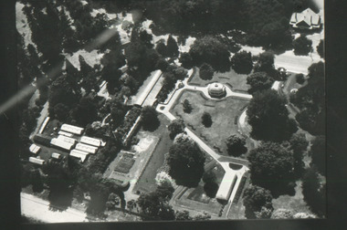
 Kew Historical Society Inc
Photograph - Aerial Photograph, Aerial Photograph of Willsmere, circa 1980, c. 1980
This aerial photograph shows the Kew Cottages, and doctors/clergy residences on the north side of Wills Street, before the State Government sold the land for residential development. The doctors residences in Wills street were made of 'Glen Iris' Olympic Bricks. According to neighbours of the time most of the buildings were demolished overnight in the 1980s.Aerial photograph of Willsmere and the Kew Cottages bounded by the Boulevard, the Chandler Highway, Princess Street and Fellows Street. The roundabout at the intersection of Princess Street, Wills Street, and Eglinton Street is at the top left. The Eastern Freeway is at the lower edge of the photograph.kew cottages, eastern freeway, willsmere, yarra river, aerial photographs -- kew (vic), kew boulevard, willsmere mental hospital, kew mental hospital, kew childrens cottages -
Whitehorse Historical Society Inc.
Pamphlet, Maroondah Highway, Nunawading, 1/10/1999 12:00:00 AM
Auction brochure for 360 Maroondah Highway, Nunawading [Whitehorse Road].Auction brochure for 360 Maroondah Highway, Nunawading [Whitehorse Road]. 3 lots for auction, 27 October 1999. Agent; Collier. Site of the former Nunawading Council Chambers. Includes aerial photo of Nunawading including Whitehorse Rd / Springvale Rd corner and Nunawading Railway Station area.Auction brochure for 360 Maroondah Highway, Nunawading [Whitehorse Road]. whitehorse road, nunawading, no 360, city of nunawading. council chambers, municipal chambers, springvale road, nunawading, nunawading railway station -
 Bendigo Historical Society Inc.
Photograph - WES HARRY COLLECTION: AERIAL VIEW OF BENDIGO CBD, 1966
Aerial photograph of the Bendigo CBD. On the reverse is written : 'City of Bendigo 1966, State aerial Surveyplace, aerial view of bendigo, cbd, bendigo cbd, aerial survey of victoria -
Whitehorse Historical Society Inc.
Map, Boronia Road, Vermont, 1970
Enlargement of aerial photograph of Boronia Road, Vermont. State Aerial Survey 1970 Run 37Enlargement of aerial photograph of Boronia Road, Vermont. State Aerial Survey 1970 Run 37Enlargement of aerial photograph of Boronia Road, Vermont. State Aerial Survey 1970 Run 37boronia road, vermont, lusk drive, vermont, morack road, vermont south, allison court, vermont, trinian street, vermont, cosgrove street, vermont, mawson court, vermont, aerial photographs -
Whitehorse Historical Society Inc.
Map, Boronia Road, Vermont, 1970
Enlargement of Aerial photograph of Boronia Road Vermont, State Aerial Survey, 1970. Run 37Enlargement of Aerial photograph of Boronia Road Vermont, State Aerial Survey, 1970. Run 37Enlargement of Aerial photograph of Boronia Road Vermont, State Aerial Survey, 1970. Run 37boronia road, vermont, gallus close, vermont, moore road, vermont, carlinga drive, vermont, beleura avenue, vermont, olinda crescent, vermont, penllyne avenue, vermont, holyrood drive, vermont, aerial photographs -
 Glenelg Shire Council Cultural Collection
Photograph - Photograph - Southern Farmers & Australian Estates (Portland) Pty Ltd Wool Process, n.d
Port of Portland Authority archives.Front: (no inscriptions) Back: (no inscriptions)port of portland archives -
 Running Rabbits Military Museum operated by the Upwey Belgrave RSL Sub Branch
Aerial
long radio aerialequipment, vietnam, army -
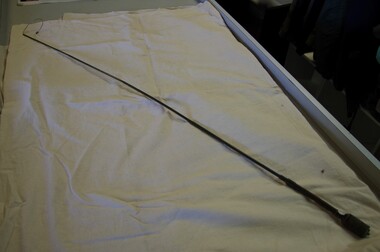
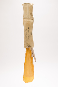 Forests Commission Retired Personnel Association (FCRPA)
Drop Chute
From the early 1960s, the Forests Commission had pre-season arrangements in place with local aeroclubs and pilots across regional Victoria. Air observers from FCV districts routinely flew during the summer months in small, fixed-wing aircraft on fire spotting missions and to map fire boundaries. The information was often needed quickly by crews on the ground or in the control centre and these small chutes were used to drop messages and maps from the reconnaissance aircraft on a low pass above a cleared area like a football field. About 3-foot long when fully extended, they had a small pouch secured with a press stud for the map or package. The chutes were made from tough canvas with a small, weighted sandbag at one end and a long yellow streamer tail on the other to help direct its fall and locating it on the ground. Drop chutes were still in common use in the 1990s, but the increased availability of helicopters combined with improved digital data transfer made drop chutes redundant. Simple, but now redundant technologyAerial drop chute"Return to Forests Comm Vic" stenciled on sidebushfire -
Stawell Historical Society Inc
Map, Aerial Photograph of Stawell, c1980
Aerial Photograph of Stawellstawell -
 Friends of Ballarat Botanical Gardens History Group
Slide - Black and white transparency
Aerial view of the gardensballarat botanical gardens, trees, parks, lawns, flowers, pounds, men, pathways, fernery, statuary pavilion -
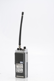
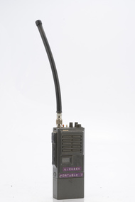 Department of Energy, Environment and Climate Action
Sawtron portable radio
After the 1939 bushfires, the Forests Commission Victoria invested heavily in a radically new communications network. After suffering some inevitable delays due to the war, radio VL3AA switched into full operation in October 1945 proudly beaming out 200 watts across the State. But by today’s standards, the technology was primitive and the reception poor unless the user was on a high point somewhere. The radio signal was "line-of-sight" and bounced between fire towers and relay transmitters across the mountains back to the District offices. The advent of solid-state electronics in the 1960s replaced the more delicate valve sets which enabled greater use of vehicle mounted radios. The Commission continued to research, develop and build new radios at its many workshops around Victoria. The network was supported by a large team of skilled radio technicians. The more secure and versatile State Mobile Radio (SMR) digital trunk system came into operation in about 1995. Upgraded Tait Radios were purchased in 2014 after recommendations of the 2009 Bushfires Royal Commission. But it was the convergence of separate technologies such as 5G mobile phones, high-capacity and light-weight lithium batteries, Wi-Fi, the ever-expanding internet, cloud data storage, digital cameras, GPS, personal organisers and hundreds of supporting Apps into powerful smartphones and tablets which revolutionised bushfire communications from the mid-2000s. Portable radio with aerialSwifts Creek portable 7bushfire, radios, forests commission victoria (fcv) -
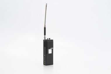
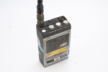 Department of Energy, Environment and Climate Action
ITT Portable radio
After the 1939 bushfires, the Forests Commission Victoria invested heavily in a radically new communications network. After suffering some inevitable delays due to the war, radio VL3AA switched into full operation in October 1945 proudly beaming out 200 watts across the State. But by today’s standards, the technology was primitive and the reception poor unless the user was on a high point somewhere. The radio signal was "line-of-sight" and bounced between fire towers and relay transmitters across the mountains back to the District offices. The advent of solid-state electronics in the 1960s replaced the more delicate valve sets which enabled greater use of vehicle mounted radios. The Commission continued to research, develop and build new radios at its many workshops around Victoria. The network was supported by a large team of skilled radio technicians. The more secure and versatile State Mobile Radio (SMR) digital trunk system came into operation in about 1995. Upgraded Tait Radios were purchased in 2014 after recommendations of the 2009 Bushfires Royal Commission. But it was the convergence of separate technologies such as 5G mobile phones, high-capacity and light-weight lithium batteries, Wi-Fi, the ever-expanding internet, cloud data storage, digital cameras, GPS, personal organisers and hundreds of supporting Apps into powerful smartphones and tablets which revolutionised bushfire communications from the mid-2000s. Portable radio with aerialCFL Orbost Regionbushfire, radios, forests commission victoria (fcv) -
 Department of Energy, Environment and Climate Action
YAESU Portable radio FTC 2300
After the 1939 bushfires, the Forests Commission Victoria invested heavily in a radically new communications network. After suffering some inevitable delays due to the war, radio VL3AA switched into full operation in October 1945 proudly beaming out 200 watts across the State. But by today’s standards, the technology was primitive and the reception poor unless the user was on a high point somewhere. The radio signal was "line-of-sight" and bounced between fire towers and relay transmitters across the mountains back to the District offices. The advent of solid-state electronics in the 1960s replaced the more delicate valve sets which enabled greater use of vehicle mounted radios. The Commission continued to research, develop and build new radios at its many workshops around Victoria. The network was supported by a large team of skilled radio technicians. The more secure and versatile State Mobile Radio (SMR) digital trunk system came into operation in about 1995. Upgraded Tait Radios were purchased in 2014 after recommendations of the 2009 Bushfires Royal Commission. But it was the convergence of separate technologies such as 5G mobile phones, high-capacity and light-weight lithium batteries, Wi-Fi, the ever-expanding internet, cloud data storage, digital cameras, GPS, personal organisers and hundreds of supporting Apps into powerful smartphones and tablets which revolutionised bushfire communications from the mid-2000s. Portable radio with aerial Bendigo Region 09/144 Res Conbushfire, radios, forests commission victoria (fcv) -
 Department of Energy, Environment and Climate Action
Midland Portable radio
After the 1939 bushfires, the Forests Commission Victoria invested heavily in a radically new communications network. After suffering some inevitable delays due to the war, radio VL3AA switched into full operation in October 1945 proudly beaming out 200 watts across the State. But by today’s standards, the technology was primitive and the reception poor unless the user was on a high point somewhere. The radio signal was "line-of-sight" and bounced between fire towers and relay transmitters across the mountains back to the District offices. The advent of solid-state electronics in the 1960s replaced the more delicate valve sets which enabled greater use of vehicle mounted radios. The Commission continued to research, develop and build new radios at its many workshops around Victoria. The network was supported by a large team of skilled radio technicians. The more secure and versatile State Mobile Radio (SMR) digital trunk system came into operation in about 1995. Upgraded Tait Radios were purchased in 2014 after recommendations of the 2009 Bushfires Royal Commission. But it was the convergence of separate technologies such as 5G mobile phones, high-capacity and light-weight lithium batteries, Wi-Fi, the ever-expanding internet, cloud data storage, digital cameras, GPS, personal organisers and hundreds of supporting Apps into powerful smartphones and tablets which revolutionised bushfire communications from the mid-2000s. Portable radio with aerial Hopetounbushfire, radios, forests commission victoria (fcv)