Showing 257 items
matching aircraft systems
-
 Moorabbin Air Museum
Archive (Item) - Box WP5 Prowse Collection See details under Description section
-
Moorabbin Air Museum
Archive (Item) - Box WP7 Prowse Collection See details under Description Section
-
Moorabbin Air Museum
Archive (Item) - Box WP8 Prowse Collection See details under Description Section
Description: Turbomeca leaflet Airvan leaflet (12 copies) Flight Computer - US Army Airforces RAAF Defence Instruction AAP 7214-003-4-11 Instrument Systems - IPB Sleigh News Dec 78 Jindivik Project Production Bulletins - Various Flight Manual - Jindivik Mk 3A A Level of Importance: State. -
Moorabbin Air Museum
Archive (Item) - Box WP10 Prowse Collection See details under Description section
Description: RAAF Defence Instruction 7211.014-1 Flight Manual, Mystere 20 (2 colpies) RAAF Defence Instruction 7212.001-2-1 Macchi MB326H General Technical Information, Descriptive Manual RAAF Defence Instruction 7212.001-100B2 Macchi MB326H Mods Level of Importance: State. -
Moorabbin Air Museum
Booklet - Military aircraft weaponry, Aircraft Weaponization Subsystem Photographs and Description September 1970
... of aircraft weapons & assoiated systems circa 1970 Aircraft ...Photographs and specifications of aircraft weapons & assoiated systems circa 1970Photographs and specifications of aircraft weapons & assoiated systems circa 1970 -
 Department of Energy, Environment and Climate Action
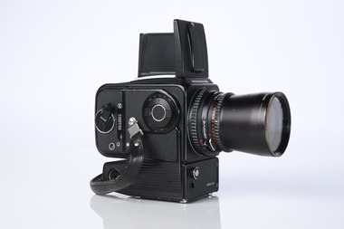
Hasselblad aerial camera
Aerial photos were used to make maps of forest types, timber resources, to survey logging areas and regeneration, to mark boundaries of public land and new plantations, to identify new roads and tracks, as well as for fire suppression. Infrared film was sometimes used to monitor insect and disease attack. The images needed to sharp, with high contrast, and in a large format (most were printed in B&W on 9-inch by 9-inch glossy photographic paper) with at least a 60% overlap to enable stereoscopic viewing and with a 20-30% side lap to allow for aircraft drift. Preferably, the photo scale was close to the final map scale avoid to problems when enlarging and to reduce distortion. Something was needed to supplement the very expensive and infrequent large-area photography programs. From the mid-1960s Victorian foresters began experimenting with small format 70mm and 35mm cameras which proved simple, practical, cheap and flexible. It was found that any SLR camera could be used provided it had a good quality lens and fast shutter speed (preferably down to 1/1000 second). Motorised cameras with a large film capacity had obvious advantages and were essential when access to the camera was not possible during flight. It is also essential for the shutter to operate at low temperatures and those lubricated with silicones were recommended. Components of a typical FCV Divisional Office system included – A Hasselblad or Vinten 70 mm format aerial camera with a focal plane shutter which could be electrically operated. Interchangeable lenses to allow for different photo scales and flying heights. Several large film magazines, which were loaded in a darkroom, each with a capacity of 100 feet or approximately 500 frames. A remote control for the camera in single-shot mode or automatic firing at selected intervals of 2 to 50 seconds. It also needed a frame counter. A light aircraft was modified with an internal mounting for the camera to keep it level and steady. Often a hole was cut through the floor for the lens. The aircraft also needed an inbuilt 12 Volt DC battery to operate the motorised camera shutter. The front passenger seat was generally removed to improve access to the camera. An Aldis drift sight was also fitted. This might be likened to an inverted periscope and is used to determine drift, to facilitate accurate navigation along flight lines and to determine the exposure interval for stereoscopic overlap. This item is kept at Traralgon.Hasselblad 500 ELM camera with 70mm lens, film pack, motor drive and battery In 1964 Hasselblad started production of a motorized camera, the 500 EL The EL/M is a modified version of the EL, "M" means modified, "EL" electric. Perhaps the most famous use of the Hasselblad camera was during the Apollo program missions when man first landed on the Moon. Almost all of the still photographs taken during these missions used modified Hasselblad cameras. forests commission victoria (fcv), forest measurement, surveying, mapping -
 Moorabbin Air Museum
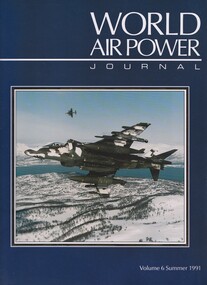
Book (item) - (SP) World Air Power Journal 06 Summer 1991
briefings: e-systems/grob egrett, myasishchev/molniya m-17 ‘mystic-b’, combat report: desert storm gulf victory, soviet airbase pushkin photo feature, lockheed f-22 feature, focus aircraft: bae/mcdonnell douglas harrier (50 pages), variant briefing: c-130 hercules part 1 – yc-130 to dc-130e, pakistan air force photo feature, fma ia-58 pucara feature, air power analysis: us air force overseas -
 Moorabbin Air Museum
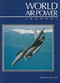
Book (item) - (SP) World Air Power Journal 36 Spring 1999
... Command and Control Systems Focus Aircraft: Lockheed Martin F-16 ...briefings: raaf scherger: the last bare base, exercise pitch black 98, rsingaf helicopter training in australia, greek air force t-33s, chilean af at red flag, air power analysis update: argentina, dam-pam ’98 french army exercise feature, us airborne command and control systems, focus aircraft: lockheed martin f-16 block 40 and beyond (50 pages), variant briefing: mig-29 ‘fulcrum’, us army aviation in korea photo feature, air power analysis: bulgaria -
Moorabbin Air Museum
Book - Aircraft maintenance, Aircraft Maintenance Text 4 Basic Functioal Devices and Systems
... and Systems Book Aircraft maintenance ...Text book on basic aircraft functional devices & systems, from levers to computers, circa 1985May be duplicate item non-fictionText book on basic aircraft functional devices & systems, from levers to computers, circa 1985 -
 Bendigo Military Museum
Photograph - 4th Field Survey Squadron deployed on Operation NERIGHT, Queensland & Northern Territory, 1989
This is a set of 19 photographs taken in 1989 during 4th Field Survey Squadron’s deployment on Operation NERIGHT 89 in Queensland and the Northern Territory. It was a two-part operation in 1989 with work conducted in the areas of Camooweal and Weipa. Part 1 was the field completion of topographic maps conducted near Camooweal QLD, along the Barkley Highway on the border between NT and QLD, from the 12th of September to the 20th of October 1989. A Bell Kiowa LOH helicopter from 162 Recce Sqn supported topographic field completion. Operation NERIGHT 89 Part 2 was the acquisition of mapping control by GPS field parties utilising Texas Instruments TI4100 Global Positioning System receivers around Weipa on Cape York Peninsula from the 22nd of September to the 22nd of October 1989. Part 2 Two Bell UH-1H Iroquois helicopters from RAAF’s 35 Squadron were principally used to deploy GPS field parties. Identification photography of control points was taken by air camera operators in AAAvn Pilatus Porter aircraft from 173 Gen Spt Sqn fitted with an RC10 aerial camera. The two parts of the operation were conducted concurrently. This is a set of 19 photographs taken in 1989 during 4th Field Survey Squadron’s deployment on Operation Neright in Queensland & the Northern Territory. The colour photographs are on 35mm negative film and are part of the Army Survey Regiment’s Collection. The photographs were scanned at 96 dpi. .1) to .3) - Photo, colour, 1989. En-route to areas of survey operations. .4) to .5) - Photo, colour, 1989. Unidentified personnel relax next to river/waterhole. .6) - Photo, colour, 1989. Two Bell UH-1H Iroquois helicopters from RAAF’s 35 SQN utilised in the movement of GPS parties. .7) to .9) - Photo, colour, 1989. Unidentified soldier practices repelling from a UH1H Iroquois helicopter. .10) - Photo, colour, 1989. Inside the cockpit of a UH1H Iroquois helicopter. .11) - Photo, colour, 1989. Field Party camp with GPS equipment in foreground. Unidentified soldier prepares a meal. .12) - Photo, colour, 1989. GPS antenna plumbed over a survey ground mark. Witness post on left. .13) & .14) - Photo, colour, 1989. Unknown Cape York Peninsula beaches. .15) & .16) - Photo, colour, 1989. Dramatic fire next to base camp. .17) - Photo, colour, 1989. Aboriginal rock art at unknown location. .18) - Photo, colour, 1989. Aboriginal rock art at unknown location. L to R: unidentified, SPR Andrew Quin. .19) - Photo, colour, 1989. Aboriginal rock art at unknown location. LT Chris Topovsek..1P to .19P – There are no personnel identified. ‘1989 OP NERIGHT’ annotated on negative sleeve.royal australian survey corps, rasvy, 4 fd svy sqn, op neright 89 -
 Moorabbin Air Museum
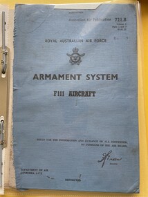
Manual (Item) - (SP) AAP RAAF Pub 721:8 Armanent System F111 Aircraft Vol 1 Parts 2 and 3
... (SP) AAP RAAF Pub 721:8 Armanent System F111 Aircraft Vol 1...Manual (SP) AAP RAAF Pub 721:8 Armanent System F111 ... -
 Moorabbin Air Museum
Manual (item) - (SP) AAP 7215.002-4-9 RAAF Pub 721:89 Lockheed Neptune Electronics Manual Schedule of Spare Parts Neptune Aircraft SP2H (A89/B) Electronic Systems Book 9 of 12
-
Moorabbin Air Museum
Document (item) - Various aircraft photos and drawings see description, CAC Misc documents and design drawings of various aircraft
xyz -
Moorabbin Air Museum
Manual - Pilot notes, Pilots Notes General
... Pilot's Notes Overview for pilot of aircraft handling ...Overview for pilot of aircraft handling, power units,systems, all weather operations & emergency procedures, circa 1951Overview for pilot of aircraft handling, power units,systems, all weather operations & emergency procedures, circa 1951 -
Moorabbin Air Museum
Book - Aircraft instruments
... Aircraft Instruments Instruments & systems Overview ...Overview of instruments & associated systems needed for flight, circa 1981non-fictionOverview of instruments & associated systems needed for flight, circa 1981instruments & systems -
 Bendigo Military Museum
Photograph - RA Svy Project C4 Aerodist Operation, Eastern Arnhem Land, NT, 1967
... 1964 to 1975. Aerodist MRC2 was a tellurometer-based system... 1964 to 1975. Aerodist MRC2 was a tellurometer-based system ...This is a set of 30 photographs of Royal Australian Survey Corps (RA Svy) personnel from Central Comd Fd Svy Unit (Adelaide) on Aerodist survey operation - Project C4 in Eastern Arnhem Land, Northern Territory in 1967. Photos of personnel were taken either at the operations base at Numbulwar or the main base at Gove (Nhulunbuy). RA Svy conducted nineteen Aerodist operations for 12 years from 1964 to 1975. Aerodist MRC2 was a tellurometer-based system adapted for aircraft to accurately measure distances between non-intervisible ground survey stations, using the aircraft as an intermediate station. Lower order geodetic results could be achieved by survey network trilateration. The measured distances between stations formed survey networks from which each station’s latitude and longitude was computed. Aerodist MRC2 was RA Svy’s major horizontal control survey tool for mainly medium scale topographic mapping (scale 1:100,000 Class A being spatially accurate to within 50 metres) in PNG, northern NT, north-west WA, Kalimantan Barat (West) Indonesia, Sumatra Indonesia, Gulf of Carpentaria and Cape York, QLD. In 1967, the Aerodist MRC2 Master equipment was installed in the aircraft featured in this set of photos, Executive Air Services’ (Essendon VIC) Grand Aero Commander VH-EXX. It was the same aircraft type and company contracted to Division of National Mapping for Aerodist MRC2 surveys. From July to October 1967 the aircraft was attached to Central Comd Fd Svy Unit (Adelaide - Major Don Ridge) on Project C4 eastern-Arnhem Land NT, where 317 Aerodist lines measuring 17,300 line miles were successfully completed. This was the most productive Aerodist project thus far. The most common helicopter used by RA Svy up to 1972 was the civilian Bell 47G-2 and the Sioux Light Observation Helicopters (LOH), the Australian Army’s equivalent featured in this photo set. These light observation helicopters had a limiting load carrying capacity of up to about 500 pounds. By comparison, one Aerodist team including two people weighed up to 1,500 pounds. Source: Royal Australian Survey Corps – Aerodist Years 1964-1975 by Peter Jensen. This is a set of 30 photographs of Royal Australian Survey Corps (RA Svy) personnel on Aerodist survey operations in Eastern Arnhem Land, Northern Territory in 1967. The photographs are on 35mm negative film and scanned at 96 dpi. They are part of the Army Survey Regiment’s Collection. .1) to .4) - black & white, 20th August 1967, Project C4 Aerodist Operations Base - Numbulwar, NT. .5) - Photo, black & white, 1967. Probable wrecked Indonesian fishing vessel. .6) to .8) - Photo, black & white, 1967. Unidentified survey operations base, L to R: unidentified personnel. .9) - Photo, black & white, 1967. Unidentified survey operations base, unidentified soldier driving a Haflinger 4x4 Light utility vehicle. .10) - Photo, black & white, 1967. Unidentified survey operations base, L to R: unidentified technician. .11) - Unidentified technician reading two survey altimeters to compute corrections to the measured distances for atmospheric refraction and to compute the sea level distances from the slope distances aircraft to the ground stations. .12) - Photo, black & white, 1967. Unidentified survey operations base, L to R: unidentified personnel. .13) to .16) - Photo, black & white, 1967. Unidentified personnel operating remote Aerodist MRC2 ground instruments. .17) to .18) - Photo, black & white, 1967. Unknown RA Svy office location. .19) to .20) - Photo, black & white, 1967. Aerodist MRC2 Master equipment. .21) to .22) - Photo, black & white, 1967. Aero Commander VH-EXX probably at Gove, NT, Central Comd Fd Svy Unit (Adelaide) – OC Major Don Ridge. .23) to .25) - Photo, black & white, 1967. Aero Commander VH-EXX probably at Gove, NT. Unidentified personnel. .26) - Photo, black & white, 1967. Aero Commander VH-EXX probably at Gove, NT. Aerodist antenna pods are visible on the aircraft. .27) to .29) - Photo, black & white, 1967. Australian Army Sioux Light Observation Helicopter (LOH) probably at Gove, NT. .30) - Photo, black & white, 1967. Panelled U337 survey station, visible as a white cross on aerial identification photo..1P to .2P – date and location on edge of film negative. .5P to .28P – no annotations .29P - annotated in white ‘RW-JEP Gove NT’ .30P - annotated in white ‘U337 Spool No1 Jun67’royal australian survey corps, rasvy, army survey regiment, army svy regt, fortuna, asr, aerodist, surveying, central comd fd svy unit -
 Moorabbin Air Museum
Manual (item) - (SP) AAP 7214.006-7-2 Technical Equipment Failure Reporting System Code Manual Canberra Aircraft (TMP AAP Code 084) Issue 4
... System Code Manual Canberra Aircraft (TMP AAP Code 084) Issue 4... Reporting System Code Manual Canberra Aircraft (TMP AAP Code 084 ... -
 Moorabbin Air Museum
Book (item) - (SP) AAP 7214.006-7-2 Technical Equipment Failure Reporting System Code Manual Canberra Aircraft (TMP AAP Code 084)
... System Code Manual Canberra Aircraft (TMP AAP Code 084)... Reporting System Code Manual Canberra Aircraft (TMP AAP Code 084) ... -
 Moorabbin Air Museum
Manual (Item) - (SP) AAP 7213.001-33CL-1-1 Firing control system checks conventional weapon loading on Mirage 111-0 aircraft
-
 Moorabbin Air Museum
Manual (Item) - (SP) AAP 7212.003-6 Winjeel Aircraft Planned Servicing Schedule System Listing
... (SP) AAP 7212.003-6 Winjeel Aircraft Planned Servicing...Manual (SP) AAP 7212.003-6 Winjeel Aircraft Planned ... -
Moorabbin Air Museum
Manual (item) - AAP 7015.002-2-13 Lockheed Neptune P2V-7 Electrical Systems Amendment List to Vol.1 Parts 2 & 3 Book 3A- Electrical Trades
Lockheed Neptune Aircraft -
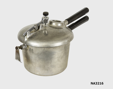 Whitehorse Historical Society Inc.
Domestic object - Pressure Cooker, c1950
Used by donor's family in the 1950s,60s,70, & 80s. They were originally made at the Commonwealth Aircraft Factory after the war to use the facilities available.Namco Pressure Cooker - a large heavy aluminium saucepan with a close fitting lid which seals on a rubber ring (missing). The lid is locked in place by wide interlocking lugs on the saucepan and the lid. It has a gauge to indicate pressure and a lever and seal system on the lid which locks into safety lock. The safety lock includes a stem release hole in which a small round plug is inserted. The pressure can be adjusted. Also included is a lead safety plug to release the steam if it overheats. Two bakelite covered steel handles aids its use.526Y on both handlesdomestic items, cooking -
 Flagstaff Hill Maritime Museum and Village
Equipment - EPIRB Transmitter
This distress EPIRB unit (Emergency Position Indication Radio Beacon) was found on the beach at Levy's Point, Warrnambool, in December 2000 by a Warrnambool resident. Local police were alerted at the time. This distress signal unit is a world-wide COSPAS/SARSAT, satellite assisted, SAR (Search and Rescue) system for location of distress transmissions emitted by an EPIRB. Offshore cruising vessels must have such a unit as part of its essential safety equipment. This model EPIRB relies on four satellites with orbit times of approximately 100 minutes. Earlier units relied solely on aircraft flying overhead to detect and forward on the EPIRB’s location to Search And Rescue authorities, whereas this new system utilises satellites. An employee from the Lokata firm provided additional information about the Lokata EPIRB units. They had a machined aluminium case with labels that were also made on site. The units could be activated manually or automatically released when a magnetic switch in the case casing was activated. This later model, circa 1983, would have been mounted externally on a vessel's bulkhead in a spring-loaded, stainless-steel protective 'skeleton' mounting, The unit released when the water pressure sensor detected a set time it was under the water, in a similar way that life crafts were released. Each unit was registered to a particular vessel - the vessel's details on this unit are indecipherable. The Lokata Company was established in 1970, designing and manufacturing marine products including communications. The company no longer makes products with the “Lokata” brand. In 2001 Sartech Engineering Ltd. took over the support for the Lokata EPIRB beacons. This emergency location device is a late 20th century invention to help save lives at sea. It adds to the history of maritime life, its risks, the lives lost as sea, and the many inventions aimed as rescuing and saving lives. The local area is notorious for the number of lives lost through shipwreck. It also carries stories of heroic efforts to save lives, and other inventions to help reduce the chance of accidents at sea.EPIRB unit; “Emergency Position Indication Radio Beacon”. A distress communication unit for sending a distress location transmission in an emergency at sea. The EPIRB is a yellow, rectangular box with dials, buttons, indicator lights and instruction. An antenna protrudes from the top of the unit. The EPIRB unit sends a 406P (X) EPIRB, with 406M-Hz frequency, 48-hour duration signal. The maker was LOKATA Ltd in England. Remnants of a white label remain on the side. Circa 1980s."NAME OF VESSEL 'SERVICE IF SELF TEST FAILS' " “LO-KATA” moulded into the body. "406P (X) EPIRB" “Model 406” "Lokata Type No 92408" "UK Type approved to MPT 1278" "Class 2" "Made by Lokata Ltd, Falmouth Cornwall England TR10 8AE"" "LOKATE LTD. New North Road Hainault, Ilford Essex IG6 2UR" "ARMED / SAFE / TRANSMIT / CODE / DISPLAY / SET / wait / pass / fail / TEST" "IDENTIFIER / 1349:24034234N" [some characters may be different] "COUNTRY / DENMARK" "VESSEL IDENTITY / 124 [the rest is indecipherable]flagstaff hill, warrnambool, shipwrecked-coast, flagstaff-hill, flagstaff-hill-maritime-museum, maritime-museum, shipwreck-coast, flagstaff-hill-maritime-village, emergency position indicating radio beacon, epirb, lokata ltd, marine safety equipment, satellite transmitting beacon, safety equipment, distress signal, life saving, safety at sea, shipwreck location, lo-kata, falmouth, emergency, beacon, radio signal, communication, marine equipment -
Moorabbin Air Museum
Manual - Beechcraft Baron D55, Beechcraft Baron Model D55 Owner's Manual
Overview of all systems , procedures & perfomance for Beechcraft Baron twin engine aircraft , circa 1967Manual in spiral bound book formnon-fictionOverview of all systems , procedures & perfomance for Beechcraft Baron twin engine aircraft , circa 1967systems -
Moorabbin Air Museum
Book - Aircraft operation, Is It On Autopilot ? HowJet Airliners Fly
... Aircraft Operation Airliner systems & autopilot Overview ...Overview of autopilot and oher flight systems in layman's terms for general reader, circa 1997Overview of autopilot and oher flight systems in layman's terms for general reader, circa 1997airliner systems & autopilot -
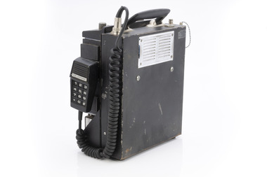 Department of Energy, Environment and Climate Action
Phillips FM 828 Radio
After the 1939 bushfires, the Forests Commission Victoria invested heavily in a radically new communications network. After suffering some inevitable delays due to the war, radio VL3AA switched into full operation in October 1945 proudly beaming out 200 watts across the State. But by today’s standards, the technology was primitive and the reception poor unless the user was on a high point somewhere. The radio signal was "line-of-sight" and bounced between fire towers and relay transmitters across the mountains back to the District offices. The advent of solid-state electronics in the 1960s replaced the more delicate valve sets which enabled greater use of vehicle mounted radios. The Commission continued to research, develop and build new radios at its many workshops around Victoria. The network was supported by a large team of skilled radio technicians. The more secure and versatile State Mobile Radio (SMR) digital trunk system came into operation in about 1995. Upgraded Tait Radios were purchased in 2014 after recommendations of the 2009 Bushfires Royal Commission. But it was the convergence of separate technologies such as 5G mobile phones, high-capacity and light-weight lithium batteries, Wi-Fi, the ever-expanding internet, cloud data storage, digital cameras, GPS, personal organisers and hundreds of supporting Apps into powerful smartphones and tablets which revolutionised bushfire communications from the mid-2000s. Aircraft radio with handsetCentral Gippsland Region 09/067bushfire, radios, forests commission victoria (fcv) -
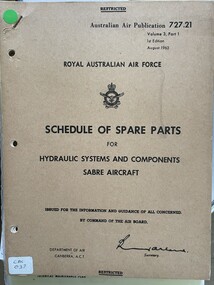 Moorabbin Air Museum
Manual (item) - (SP) AAP RAAF Pub 727:21 Schedule of Spare Parts for Hydraulic Systems and Components Sabre Aircraft
... Hydraulic Systems and Components Sabre Aircraft ... for Hydraulic Systems and Components Sabre Aircraft ... -
 Moorabbin Air Museum
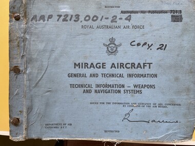
Manual (Item) - (SP) AAP 7213.001-2-4 RAAF Pub 721:3 Mirage aircraft general and technical information weapons and navigation systems Volume 1 Part 2 Book 1
-
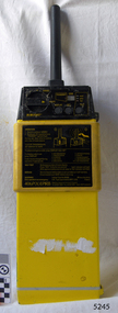
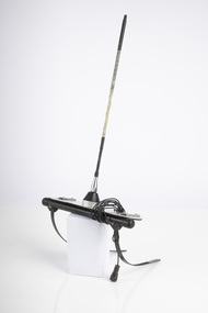 Department of Energy, Environment and Climate Action
Portable radio aerial
After the 1939 bushfires, the Forests Commission Victoria invested heavily in a radically new communications network. After suffering some inevitable delays due to the war, radio VL3AA switched into full operation in October 1945 proudly beaming out 200 watts across the State. But by today’s standards, the technology was primitive and the reception poor unless the user was on a high point somewhere. The radio signal was "line-of-sight" and bounced between fire towers and relay transmitters across the mountains back to the District offices. The advent of solid-state electronics in the 1960s replaced the more delicate valve sets which enabled greater use of vehicle mounted radios. The Commission continued to research, develop and build new radios at its many workshops around Victoria. The network was supported by a large team of skilled radio technicians. The more secure and versatile State Mobile Radio (SMR) digital trunk system came into operation in about 1995. Upgraded Tait Radios were purchased in 2014 after recommendations of the 2009 Bushfires Royal Commission. But it was the convergence of separate technologies such as 5G mobile phones, high-capacity and light-weight lithium batteries, Wi-Fi, the ever-expanding internet, cloud data storage, digital cameras, GPS, personal organisers and hundreds of supporting Apps into powerful smartphones and tablets which revolutionised bushfire communications from the mid-2000s. Radio Aerial for use with aircraftbushfire, radios, forests commission victoria (fcv) -
Moorabbin Air Museum
Book - Aeronautical Engineering, The Rigging Maintenance And Inspection Of Aircraft ("A" Licence)
... Instrument testing Electrical systems Overview of aircraft rigging ...Overview of aircraft rigging, maintenance & inspection for A licence applicants, circa 1941May be duplicate item non-fictionOverview of aircraft rigging, maintenance & inspection for A licence applicants, circa 1941assembly & rigging, material defects & deterioration, hydraulics, seaplanes & flying boats, instrument testing, electrical systems