Showing 15877 items
matching areas
-
 University of Melbourne, Burnley Campus Archives
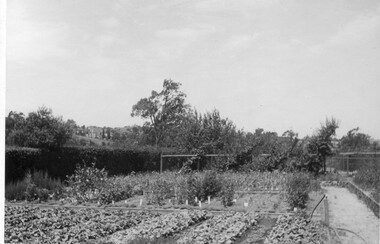
Photograph - Black and white print, Nursery Area of Orchard, Unknown
Note by E.B. Littlejohn, "Nursery area. Note Cordon pears on Orchard fence. Gladiolus trials, Boxthorn hedge."Black and white photograph. Nursery area. Note Cordon pears on Orchard fence. Gladiolus trials. Boxthorn hedge.(E. B. Littlejohn)nursery, pears, orchard, gladiolus, boxthorn hedge, cordon -
 Lakes Entrance Historical Society
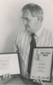
Photograph - Ray Barling, Lakes Post Newspaper, 1/08/1995 12:00:00 AM
Ray Barling holding two awards for his contribution to many areas of sport in Gippsland Lakes Entrance VictoriaBlack and white photograph of Ray Barling holding two awards for his contribution to many areas of sport in Gippsland Lakes Entrance Victoriapeople, awards -
 Halls Gap & Grampians Historical Society
Photograph, C 1900s
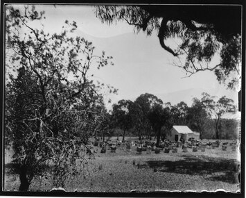
The photo shows Mr Russell at a bee site in the Cherrypool area.The photo shows a man standing among a large group of bee-hives. The hives are in six long rows in a fairly open area with eucalyptus trees scattered around it.misc industries, bee-keeping, scenery, cherrypool -
 Sunshine and District Historical Society Incorporated
Map (1967), CITY OF SUNSHINE, June 1967, 1967
The City of Sunshine no longer exists. Part of the eastern area has been annexed by the City of Maribyrnong, and the rest of the old City of Sunshine has been amalgamated with the City of Keilor to form the larger City of Brimbank.This 1967 map is a historical record of the City of Sunshine as it existed 27 years before the amalgamation of Councils, and the creation of the City of Brimbank in 1994.Whitish paper map with black printing that is laminated in clear plastic film, and has a wood slat attached to the top edge. The June 1967 map is of the previous CITY OF SUNSHINE showing City and Parish boundaries, streets, railways, creeks, river etc.Purple ink stamps at top left hand and right hand areas showing address and contact details of 'Sunshine Industrial Promotion Centre.'city of sunshine, june 1967, map, city, parish, boundaries, brimbank -
 Hume City Civic Collection
Photograph, 1/08/1986
A series of photographs were taken when heavy snow fell in Sunbury in August 1986. The snow began falling overnight and remained on the ground for 24 hours. Snow fell across the metropolitan area during that 24 hour period in a very unusual event for the area.A coloured photograph of the new main entrance to the former Shire of Bulla Council Offices and the garden immediately outside the portico area. The trees are bare and the lawn is covered with snow.snow falls, weather patterns, shire of bulla council offices, george evans collection -
 Kiewa Valley Historical Society
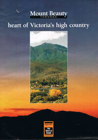
Poster Brochure, Mt Beauty Tawonga Heart Of Victoria's High Country, Circa 1995
The Item is a pictorial time piece of the valley and usage, farms,industry,town area, vegetation and winter snow levels Historical and the social-economical development at circa 1995 of land usage and residential buildings style.Major social events e.g. Festival of the Bogong Moth and the Mt Beauty Mardi Gras. It is also a good historical record of tourism campaigns of the Alpine Shire and Mt Beauty Chamber of Commerce. Also see "KVHS 0125"Brochure folds out from a 20.5cm x 29.5cm to 82cm x 29.5cm poster type documentinside panoramic photo of snow tipped alpine mountain range incorporating the Mount Beauty township, farming area of the Kiewa Valley and relevant tourist orientated informationtourism mt beauty tawonga photographs, victorian alps -
 The Foundling Archive
Training Notes- Military, Ex Secret Training Notes- George A. Turner (Jr), May 1956
Paper, purple typing."Ex Secret" Puckapunyal Training Area -
 Warrnambool and District Historical Society Inc.
Document, Map: Lady Bay 1853, 1853
This is one of the earliest surveys and maps of Warrnambool harbor, Lady Bay. Being done in 1853, it shows the depths of the bay area marked in fathoms, currents and directions and areas of rocks around mouth of the Merri and the Western side of the bay as well as a large sand spit to the middle right of the beach region.. It also marks the large areas of seaweed and fuci in the outer bay area. It has the area of Pertobe Lagoon marked and shows the early tracks to the town. The engraving work was done by Tulloch and Brown, with Tulloch being one of the earliest engravers and lithographers in the state of Victoria. He arrived in Melbourne in 1849 and set up business with James Davie Brown in 1853 with Brown being a map engraver. They were awarded bronze and silver medals for their work at the Victorian Industrial Exhibition. He also worked in the vignettes on the Proeschel Map of Victoria.This map is of high historical and comparitive significance as it shows the Lady Bay area prior to the changes that have occurred in the last 160 years with the building of the breakwater. The issue regarding access to Lady Bay remains a current one. The engraver D Tulloch engraved some of the earliest scenes of the goldfields in Ballarat and as such has left a record of a very early and important era in Australian history. Rectangular cream paper with black text. Map area is outlined by fine black lined border. Key in top right hand corner and scale at bottom middle of map.Map is labelled Town of Warrnambool printed at top of map. Small logo at top right corner which has “Hydrographic Department” in circle around an anchor. Lady Bay Warrnambool Surveyed by John Barrow assistant surveyor Engraved by Tulloch & Brown in bottom right corner. Melbourne engraved by order of the legislative Council of Victoria in middle bottom.map, warrnambool, town of warrnambool map 1853, tulloch & brown map 1853, lady bay warrnambool,, warrnambool harbour, warrnambool breakwater, warrnambool beach -
Whitehorse Historical Society Inc.
Document, Fromelles, 2012
Transcription of talk on the Battle of Fromelles.Transcription of talk on the Battle of Fromelles by Lambos Englezos to Whitehorse Historical Society 14 April 2012. With map of battle area. Tape at NP 3908Transcription of talk on the Battle of Fromelles.world war 1914-1918, fromelles -
 Lakes Entrance Historical Society
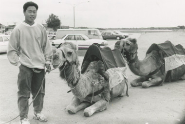
Photograph - Woodend Camel Farm Lakes Entrance Victoria, Lakes Post Newspaper, 1/12/1995 12:00:00 AM
Kym Handley of Woodend Camel Farm with two camels on the sand area east of the Footbridge Lakes Entrance VictoriaBlack and white photograph showing Kym Handley of Woodend Camel Farm with two camels on the sand area east of the Footbridge Lakes Entrance Victoriatourism, festival, animals, farm -
 Halls Gap & Grampians Historical Society
Photograph - B/W, C 1900s
Bee-hives in front of a shed in the Cherrypool area. The second (transparency) copy is No. 242 in the slide box.The photo shows bee-hives in front of a shed in a cleared area surrounded by eucalyptus trees. The faint outline of high mountains can bee seen in the background.misc industries, bee-keeping, scenery, cherrypool -
 Whitehorse Historical Society Inc.
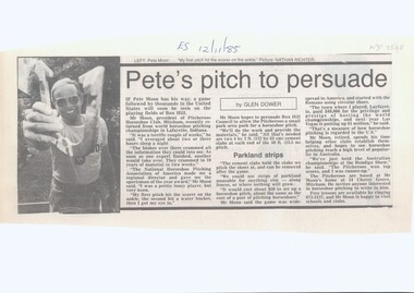
Article, Pete's Pitch To Persuade, 1985
Pete Moon, president of the Pitcheroos Horseshoe Club, Mitcham.Pete Moon, president of the Pitcheroos Horseshoe Club, Mitcham, is keen to persuade the Box Hill Council to provide a small park area for a horseshoe pitch to be constructed.Pete Moon, president of the Pitcheroos Horseshoe Club, Mitcham. moon, pete, pitcheroos horseshoe club, mitcham, cherry grove, mitcham no. 14, city of box hill -
 Hume City Civic Collection
Photograph
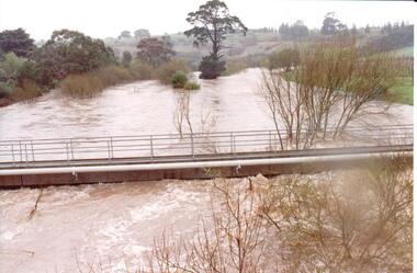
The series of photographs were taken after exceptional heavy rain had fallen in Sunbury in the early 1990s. Jackson's Creek overflowed its banks and the surrounding flood plain area was under water.A coloured photograph of Jackson's Creek in flood taken near the footbridge in Macedon Street. The Nook area and Goonawarra Vineyard are in the background.floods, weather patterns, jacksons creek, george evans collection -
Whitehorse Historical Society Inc.
Map, Nunawading Planning Scheme. Local Section, 1993
Map of City of Nunawading.Map of City of Nunawading showing zoning of areas by means of colours and some detailed designations. Note: ' This map contains amendments as at 14 Oct 1993'Map of City of Nunawading.city of nunawading, maps, land use -
4th/19th Prince of Wales's Light Horse Regiment Unit History Room
Framed Photograph, 8th Light Horse Regiment, 1914
Landscape framed photograph showing 8th Light Horse Regiment, A Squadron leading returning from exercise in the Greensborough area after trialling Wileys (sic) field cooker8th Light Horse Regiment, A Squadron leading returning from exercise in the Greensborough area after trialling Wileys (sic) field cooker late 1914. Presented to the CO and members of the 4/19 PWLH Regiment from WO1 Allan Hawkins ASM 15 March 2005 -
 Mt Dandenong & District Historical Society Inc.
Photograph, Harmony Vale 1933
John Lundy-Clarke grew up in the Kalorama/Mt Dandenong area and later in life (1972-74) began to write a comprehensive history of the area working from an original settlement map in an effort to cover all areas. Harmony Vale was the name of the homestead built by early pioneer Jabez Richardson. The whole of the valley took on this name. The building lasted until 1933. The Silvan Dam was completed in 1932 and was full when this photograph was taken.Black and white photograph looking down over a forested area with a dam in the background. Copied from a Rose Series postcard c1933. Handwritten inscription on reverse by John Lundy-ClarkeRose Series photo of 1933 showing “Harmony Vale” still standing. Copied 1973 JLCharmony vale, silvan dam, jabez richardson -
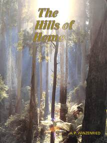 Ringwood and District Historical Society
Book, Arthur Paul Winzenried, The Hills of Home - A.P. Winzenried, 1988
Soft covered book by Arthur Paul Winzenried. Full title: The Hills of Home - A Bicentennial History of the Shire of Sherbrooke (Victoria, Australia), including captioned colour and black & white photographs of the area.Cover - "Poems are made by fools like me, But only God can make a tree" - Joyce Kilmer. Photo Neil McLeod. Acknowledgements include thanks for members of the Sherbrooke Historical Society who gave their assistance which was particularly useful in the area of photographic materials. -
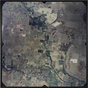 Bacchus Marsh & District Historical Society
Photograph, Aerial image of Bacchus Marsh and Darley in 1994
A whole of town and nearby area aerial image of Bacchus Marsh produced for display in the Arbee Real Estate Agency premises in Main Street, Bacchus Marsh.A large framed colour aerial photograph showing the township of Bacchus Marsh, the neighbouring smaller community of Darley, and the nearby areas of both places. "Bacchus Marsh - Darley. Aerial Photo 27 November, 1994. Presented by Arbee Real Estate "Professionals"'arbee real estate agency bacchus marsh, aerial views bacchus marsh vic. -
 Victorian Interpretive Projects Inc.
Photograph - colour, Clare Gervasoni, Rock Art in the Playground of the Former Dry Diggings Primary School, 05/08/2004
The Dry Diggings area is located outside Hepburn Springs in the shadow of Mount Franklin. It was an early goldmining area, but little remains of the thriving town of the 1860s. Colour photograph in digital format of the shape of Australia carved into a rock in the playground of the former Dry Diggings Primary School near Hepburn Springs and Daylesford. The carved area has been filled with white quartz stone. dry diggings, education, rock, -
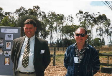 Sunbury Family History and Heritage Society Inc.
Photograph, Veronica Burgess, 12th December 1999
The two men are Alan McKenzie and Trevor Dunn, who are cousins and long-time residents of the Sunbury - Bulla area. They were guests at the official opening of the Alister Clark Memorial Rose Garden in Bulla, which took place on 12th December 1999.Both men are long time residents of the area and have been involved in many community activities.A non-digital coloured photograph of two men standing in an open area with photographs on a display board to the LHS of the image.alan mckenzie, trevor dunn, alister clark memorial rose garden, bulla -
 Bendigo Military Museum
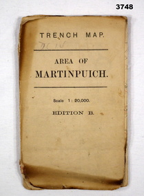
Map - TRENCH MAP WW1, 1916
Areas covered by this map are, “Longueval, Delville Wood, Flers, Thiepval”. Item re William Alexander No 502 AIF. Refer Cat No 3746.3 for his service details.Trench map, France, Area of Martin Puch, scale 1:20,000 Edition B, trenches corrected to 24.7.1916, enemy trenches in red.map, trench, france -
 Frankston RSL Sub Branch
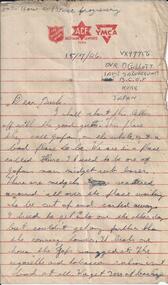
Letter
A letter sent to Australia by an Australian Army serviceman whilst on duty in Kure, Japan during the post World War 2 occupation. The serviceman is Driver B. Gillott service number VX97756, of the 1 Australian Salvage Unit of the B.C.O.F. The letter is dated 15th July, 1946 and is of five handwritten pages of approximately 8 x 5 inches in size. The stationery is printed in red ink with the Salvation Army, Australian Comforts Fund and YMCA insignia above the ruled writing area. The paper is a buff colour.This writing paper has the insignia of The Salvation Army, Australian Comforts Fund and YMCA printed in red above the ruled writing area. -
 Marysville & District Historical Society
Photograph (Item) - Black and white photograph, 1993
A black and white photograph taken at the re-opening of the Wilks Creek Bridge picnic area and launch of Ann Thomas' book Wilks Creek Bridge.A black and white photograph taken at the re-opening of the Wilks Creek Bridge picnic area and launch of Ann Thomas' book Wilks Creek Bridge. The Wilks Creek Bridge is a former timber and bluestone road bridge on the Yarra Track, and is located just off the Black Spur route, between Narbethong and Marysville, Victoria, Australia. It was built in 1870 to the design of colonial Public Works Department engineer Clement Wilks as part of the construction of a new road to the Woods Point and Jordan Goldfields. Like many bridges of the period, it had a timber superstructure employing squared beams supported by struts and straining pieces, on cut bluestone abutments. The bridge was remodelled around 1900 by engineer John Monash of the famous bridge-engineering firm of Monash and Anderson. It was last used for heavy vehicular traffic in 1980 following the realignment of Marysville Road, and was left to decay until its demolishment in 2008. All timber traces of the bridge were destroyed in the 2009 Black Saturday fires. The handcrafted bluestone masonry wingwalls and abutments, especially shaped to receive timber struts, rate among the earliest of its kind surviving intact in Victoria.wilks creek bridge, yarra track, narbethong, marysville, victoria, clement wilks, wood's point goldfields, jordan goldfields, john monash, monash and anderson, 2009 black saturday bushfires -
 Bendigo Military Museum
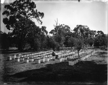
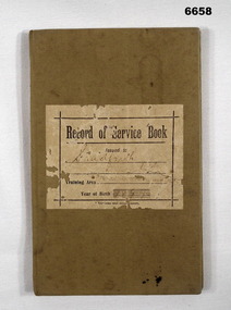
Administrative record - RECORD OF SERVICE BOOK, Commonwealth of Australia, 1910
Record Book R. M. SHADFORTH. Registered 30.1.1913 - Schoolboy, 29 Wattle St. Bendigo. Apptn record - last entry 16.11.1937 - Promoted to MAJOR. Gazette Notice 31/37.Book - Cloth hard cardboard cover, khaki colour, 62 pages, black print."Record of Service Book" Issued to SHADFORTH R.M., Training Area, Area 67, Golden Square. Year of Birth 1899.passchendaele barracks trust, service book -
 Bendigo Military Museum
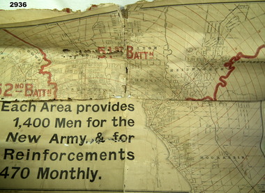
Map - MAP, RECRUITING AREAS, Sands & McDougall Pty Ltd, Possible WW1 era
Each Battalion area provided 1400 men for the New Army & for 470 Reinforcements monthly.Map, paper on canvas backing, depicts recruiting areas for the raising & maintenance of Territorial Battalions in Melbourne (Vic) & suburbs. Printing is black & white with battalion boundaries & names in red.maps, battalions, recruiting -
 Surrey Hills Historical Society Collection
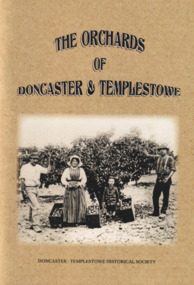
Book, The Orchards of Doncaster & Templestowe
For 100 years Doncaster-Templestowe was a major fruit producing area. The industry had a profound effect on the landscape and vegetation. Although orcharding families came from a variety of backgrounds, German families were an important sub-group.A comprehensive history of fruit growing in the Doncaster-Templestowe area between 1850s and 1950s when orchards began to be subdivided for housing. It includes B&W photos and line drawings and maps. It covers details of the varieties grown, the families involved, pests, machinery involved, markets, blacksmiths and reasons for the demise of the industry in the area.irvine green, eric collyer, doncaster-templestowe historical society, gottlieb thiele, ruffey creek, bismarck street, victoria street, thomas petty, george hislop, john whitten, john clay, august aumann, carl hanke, gottfried uebergang, waldau, max schramm, german lane, george street, john tully, henry crouch, george tortice, august zerbe, jane serpell, sidney williams, phylloxera, joseph bosisto, richard serpell, frederick thiele, w s williams, edwin lawford, james read, john finger, richard clay, ferdinand finger, leeds street, wetherby road, john russell, sarah uebergang, mary hislop, rudolph werner, john petty, archibald mclaren, john hicks, joe hicks, john smedley, william smedley, william hunter, sylvester mullens, laurie's forge, curtis hillman, anne hillman, dan harvey, calder's forge, hillman's blacksmith works, thomas serpell, gill smith, victorian fruit growers association, h g reynolds, alfred thiele, william webb, fred zerbe, mary anne clay, orchardist's coolstore, r h werner & co, j h land, orchardists and fruit cool stores association, a t petty, r read, r chivers, jack noonan, arthur ireland, jack robinson, george knee, donvale cool store, herb petty, frank petty, fred tolly, gordon white, blue moon fruit co-operative ltd, kathleen petty, peg chivers, jack russell, mathew adams, george mcgahy, edwin bullock, james hodson, edwin wilson, david corbett, edwin lowford, thomas beavis, william hanke, tom petty, edward crossman, andrew zander, carl aumann, heinrich fromhold, thomas chivers, william williams, reinhold denhert, henry finger, august furhmann, henry serpell, john ireland, frank smedley, william kent, william knee, thomas buck, henry white, gottlieb leber, alexander speers -
MYLI My Community Library
Map - Nar Nar Goon County of Mornington Map, 1944, H.E Daw - Government Printer, June 1944
This was a map made in the period before Cardinia shire was created in 1994. With intricate labelling of lot allocations, this map is a invaluable research potential for understanding the settlement of the area and its development in the first half of the 1900s. A paper map with yellow shaded areas and black ink.On Left Side: Pakenham (lot numbers throughout the map) Top side: Gembrook, Tonimbuk Right Side: Bunyip, Koo-wee-rup East Bottom Side: By Authority: / H.E. Daw Government Printer / Melbourne Koo-wee-rup Bottom Right Corner: NOTE: The allotments colored brown are freehold. In respect of which the name. The Area, and the Date where given, are the particulars set out in the Crown grant as issued by the Lands Department. / After the issue of the Crown Grant, all subsequent dealings are effected at the office of titles, Queen Street, Melbourne, and particulars as to present registered ownership, boundaries, subdivisions, etc., may be obtained by search at that office. / This plan has been compiled from the Lands Department Record as at June 1944 / Nar-Nar-Goon / County of Mornington / Drawn and reproduced at the department of lands and survey, Melbourne Price 2/. June 1944 h.e. daw, map, nar-nar-goon, county of mornington, pakenham, koo-wee-rup -
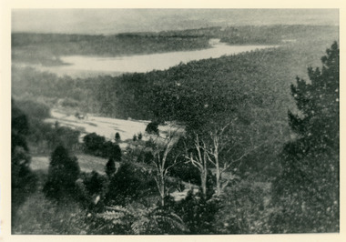
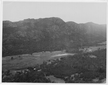 Halls Gap & Grampians Historical Society
Photograph
Photo depicts Fyans Valley. The road is The Grampians/ Dunkeld Road, leading to Dunkeld towards the right or Halls Gap travelling towards the left. Fyans Creek is visible in parts at the foot of the range (middle of Photo). Photo appears to have been taken from Bellfield Pk area. Photo is typical of those taken by Forests Commission of Victoria in the 1960sPhoto shows a mountain range in the background with a valley. The Valley has a band of a mostly cleared grassy section (middle of photo) with a fairly dense treed area in the foreground. A road and some buildings can be seen where the cleared land meets the treed area.scenery, fyans valley