Showing 9254 items
matching baily
-
 Port Melbourne Historical & Preservation Society
Booklet, Open Space 2000. Bay to ranges, Caring for Port Phillip Bay. Now and into the future, 2000
"Caring for Port Phillip Bay. Now and into the future" Booklet with blue and white cover and coloured map of Port Phillip Bay and surrounding area.natural environment, maritime, port phillip bay -
 National Vietnam Veterans Museum (NVVM)
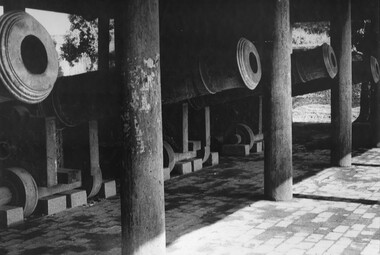
Photograph, Gibbons, Denis, Cannon Battery
A black and white photograph of a part of a battery of large cannon sit in their bay at the Imperial Palace Hue, South Vietnam. The cannon appear to be waiting for the warlords' hordes to attach from the north. The cannon are kept in very good order and condition by staff at the palace. (circa April 1966)A black and white photograph of a part of a battery of large cannon sit in their bay at the Imperial Palace Hue, South Vietnam. The cannon appear to be waiting for the warlords' hordes to attach from the north. The cannon are kept in very good order and condition by staff at the palace. (circa April 1966)photograph, imperial palace, hue, gibbons collection catalogue, cannon, denis gibbons -
 Glenelg Shire Council Cultural Collection
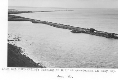
Photograph - Photograph - Lady Bay Reclamation: Dumping of surplus overburden in Lady Bay, January 1960, 1960
Port of Portland Authority archivesFront: (no inscriptions) Back: (no inscriptions)port of portland archives, lady bay, reclamation, 1960s -
 Glenelg Shire Council Cultural Collection
Photograph - Photograph - Lady Bay Reclamation: Dumping of surplus overburden in Lady Bay, January 1960, 1960
Port of Portland Authority archivesFront: (no inscriptions) Back: (no inscriptions)port of portland archives, reclamation, lady bay -
Port Melbourne Historical & Preservation Society
Photograph - Bay Street, Charles Nettleton, c1880
Photograph of Bay Street looking towards Hobson's Bay. Circa 1880. There is shipping in background and HMS Nelson on the right. Sepia print mounted on card." C Nettleton" - Melbournehms nelson, bay street, conen & marks, london & dublin loan office, charles nettleton, built environment - commercial, cheap boot and shoe store, transport - shipping -
 Port Melbourne Historical & Preservation Society
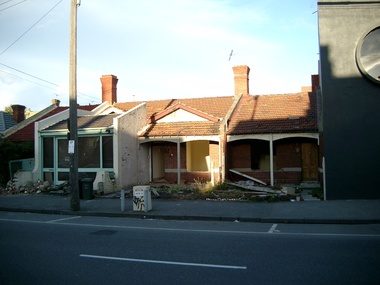
Photograph - Demolition of cottages in Bay Street, Port Melbourne, Glen Stuart, 25 Jul 2003
One of these cottages formerly belonged to Mayor Perce WHITETwo colour photos of demolition of cottages in Bay Street between Graham and Little Bay Streets, in preparation for the ill-fated "Muir"apartment complex.built environment - domestic, muir, bay street -
Port Melbourne Historical & Preservation Society
Photograph - Fountain Inn and Bay Street from Port Melbourne Town Hall clocktower, David Thompson, Feb 1994
One of three photos of Bay Street taken from the Town Hall clocktower February 1994 by David Thompson: Bay Street and Fountain InnDetails on back in inkbuilt environment -
 Flagstaff Hill Maritime Museum and Village
Photograph
Photograph of Lady Bay 1860s including ships.flagstaff hill, warrnambool, shipwrecked-coast, flagstaff-hill, flagstaff-hill-maritime-museum, maritime-museum, shipwreck-coast, flagstaff-hill-maritime-village, photograph -
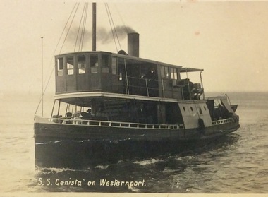 Phillip Island and District Historical Society Inc.
Photograph, Genista on Western Port
S.S.Genista - built 1886, Sydney. Western Port Ferry 1889 to early 1930's.S.S. Genista sailing on Western Port Bay.local history, photographs, transport, shipping, maritime technology, fisheries, ferries, black & white photograph, phillip island, western port -
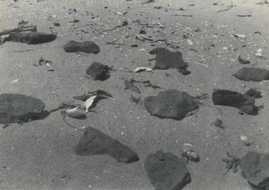 Phillip Island and District Historical Society Inc.
Photograph
One of a collection of over 400 photographs in an album commenced in 1960 and presented to the Phillip Island & Westernport Historical Society by the Shire of Phillip IslandPhotograph of the remains of Aboriginal Ovens at Cat Baylocal history, photography, aboriginal ovens, black & white photograph, aborigines, cooking & feasting, h r balfour, john jenner, bryant west -
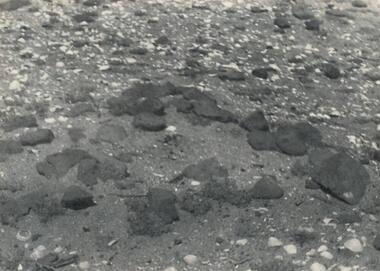 Phillip Island and District Historical Society Inc.
Photograph, H. R. Balfour
One of a collection of over 400 photographs in an album commenced in 1960 and presented to the Phillip Island & Westernport Historical Society by the Shire of Phillip IslandPhotograph of the remnants of Aboriginal feasting at Cat Baylocal history, photography, aboriginal feast site, black & white photograph, aborigines, cooking & feasting, h r balfour, john jenner, bryant west -
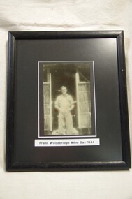 Running Rabbits Military Museum operated by the Upwey Belgrave RSL Sub Branch
Photo
Photo of Frank Woodbridge at Milne Bay in 1944photo, ww2, army -
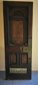 Queenscliffe Maritime Museum
Functional object - Door from SS Edina, 1854
A ships relic from a well known Screw Steam vessel SS Edina which operated in Port Phillip for many yearsA door from bay steamer SS Edinass edina, salvage, bay steamers of port phillip -
Glenelg Shire Council Cultural Collection
Map - Map - Portland, 1950s
White card with 2 maps of Portland; larger one showing the town and harbour, smaller one of town, Portland Bay, Bridgewater Bay, Nelson Bay, Lawrence Rocks. Also Portland phone numbers: Ambulance Hospital, Police, Fire, Taxi, Electricianmap, portland, portland harbour, cape bridgewater, south west coastline -
Queenscliffe Maritime Museum
Geological specimen - Copper ore
The Empress of the Sea was a magnificent three masted, square rigged, wooden sailing clipper ship built in Boston, USA. The Empress of the Sea is historically and archaeologically significant as it was one of Donald Mackay's famous wooden clipper ships, i.e. representative of a particular design or type. It was also associated with both the Black Ball and White Star Lines of Australian Packets, which carried thousands of immigrants from Britain to Australia. The Empress of the Sea caught fire at Queenscliff at 4 am on 19 December 1861. When the officer of the watch attempted to extinguish the fire they found fire pump handles missing and buckets ineffective. Fire became out of control and the ship was sailed from anchorage and ran ashore at Point Nepean. Ship rolled over onto starboard side by force of the tide and the shifting ballast. The port side was burnt to the copper. The Empress of the Sea lies in 5 metres (16 feet) to 7 metres (23 feet) of water, 700 metres (2,297 feet) offshore from Nepean Bay, Port Phillip. The site covers an area 150 metres (492 feet) long and 50 metres (164 feet) wide. The bow lies towards the south-west. Piece of copper ore, possibly part of ships cargo, recovered from the site of the Empress of the Sea shipwrecked in Nepean Bay 1861shipwrecks, nepean bay, empress of the sea -
![Township of Lorne, and Loutitt Bay / [by] Nicholas Caire, circa 1876](/media/collectors/550653872162f11fb04854aa/items/5783458ad0cdd1176c6f0c78/item-media/578345eed0cdd1176c6f852b/item-fit-380x285.jpg) Kew Historical Society Inc
Kew Historical Society IncPhotograph, Anglo-Australasian Photographic Company, Township of Lorne, and Loutitt Bay, c. 1876
Nicholas Caire was born on Guernsey in the Channel Islands in 1837. He arrived in Adelaide with his parents in about 1860. In 1867, following photographic journeys in Gippsland, he opened a studio in Adelaide. From 1870 to 1876 he lived and worked in Talbot in Central Victoria. In 1876 he purchased T. F. Chuck's studios in the Royal Arcade Melbourne. In 1885, following the introduction of dry plate photography, he began a series of landscape series, which were commercially successful. As a photographer, he travelled extensively through Victoria, photographing places few of his contemporaries had previously seen. He died in 1918. Reference: Jack Cato, 'Caire, Nicholas John (1837–1918)', Australian Dictionary of Biography.An original, rare photograph from the series 'Views of Victoria: General Series' by the photographer, Nicholas Caire (1837-1918). The 60 photographs that comprise the series were issued c. 1876 and reinforced a neo-Romantic view of the Australian landscape to which a growing nationalist movement would respond. Nicholas Caire was active as a photographer in Australia from 1858 until his death in 1918. His vision of the Australian bush and pioneer life had a counterpart in the works of Henry Lawson and other nationalist poets, authors and painters.‘Township of Lorne, and Loutitt Bay’ : Views of Victoria (General Series) No.60 : Albumen silver photograph | Photo on card with Title and Description on reverse | Mounted 24 x 30 cm; Photo 12 x 17 cm.On Reverse: ‘Loutitt Bay is fast becoming one of the most fashionable Watering-places in Victoria, partly from its easy access by Rail, combined with the magnificent scenery to be found in the Cape Otway Ranges, and the very moderate charges of the houses of accommodation. The large house near the foreground is that of Mr. Mountjoy, which is a Restaurant. Duncan’s Hotel can be seen in the distance, on the brow of the hill.’nicholas caire (1837-1918), lorne (vic), duncan's hotel, loutitt bay, landscape photography - victoria -
 Port Melbourne Historical & Preservation Society
Photograph - Athens Olympic Torch in Port Melbourne, David Thompson, 5 Jun 2004
The torch was carried through a record number of 26 countries, passing through Melbourne on Saturday 5th June 2004. It returned to Athens for the August games. Enormous crowds turned out to see it go down Bay StreetFrom a set of digital photos taken by David THOMPSON on the occasion of the Athens Olympic torch passing through Port Melbourne - 5 June 2004. On satin finish: .01 - Torch bearer 45, Greg KINROSS, in Bay Street (Note promotional banner with PMH member Christine NICHOLSON on left) .02 - Torch bearer 45, Greg KINROSS, outside Town Hall .03 - Torch bearer 47, Jim Dimas, turning from Bay Street into Beach Street On plain paper: .04 - Torch bearer 47, Jim Dimas, outside of front of Morley's Coal store .05 - Torch bearer 47, Jim Dimas, passing flame to Felix Ho .06 - Torch bearer 48, Felix Ho, in Beach Street Ref item 1894.07 for infoolympic games, celebrations fetes and exhibitions, sport, christine nicholson, greg kinross -
 Warrnambool and District Historical Society Inc.
Document, Map: Lady Bay 1853, 1853
This is one of the earliest surveys and maps of Warrnambool harbor, Lady Bay. Being done in 1853, it shows the depths of the bay area marked in fathoms, currents and directions and areas of rocks around mouth of the Merri and the Western side of the bay as well as a large sand spit to the middle right of the beach region.. It also marks the large areas of seaweed and fuci in the outer bay area. It has the area of Pertobe Lagoon marked and shows the early tracks to the town. The engraving work was done by Tulloch and Brown, with Tulloch being one of the earliest engravers and lithographers in the state of Victoria. He arrived in Melbourne in 1849 and set up business with James Davie Brown in 1853 with Brown being a map engraver. They were awarded bronze and silver medals for their work at the Victorian Industrial Exhibition. He also worked in the vignettes on the Proeschel Map of Victoria.This map is of high historical and comparitive significance as it shows the Lady Bay area prior to the changes that have occurred in the last 160 years with the building of the breakwater. The issue regarding access to Lady Bay remains a current one. The engraver D Tulloch engraved some of the earliest scenes of the goldfields in Ballarat and as such has left a record of a very early and important era in Australian history. Rectangular cream paper with black text. Map area is outlined by fine black lined border. Key in top right hand corner and scale at bottom middle of map.Map is labelled Town of Warrnambool printed at top of map. Small logo at top right corner which has “Hydrographic Department” in circle around an anchor. Lady Bay Warrnambool Surveyed by John Barrow assistant surveyor Engraved by Tulloch & Brown in bottom right corner. Melbourne engraved by order of the legislative Council of Victoria in middle bottom.map, warrnambool, town of warrnambool map 1853, tulloch & brown map 1853, lady bay warrnambool,, warrnambool harbour, warrnambool breakwater, warrnambool beach -
Frankston RSL Sub Branch
Souvenir Tablecloth, 1915 (estimated)
Gold coloured silk tablecloth with green braid edging and mauve silk fringing. It is heavily embroidered with various flags, crowns and flowers relating to the Gallipoli campaign. Possibly made in Eygpt. The flags featured are Australia, France, United Kingdom, Egypt, Japan, Italy, Belgium and Russia. Some fraying along folds. The RAN Bridging Train (RANBT) was a naval reserves unit trained to provided engineering support such as assembling pontoons, temporary jetties and unloading stores. The 1st RANBT supported the British landing at Suvla Bay (north of ANZAC Cove) on the 7th of August 1915.In the centre of the tablecloth, embroidered in blue silk thread, are the following words "Suvla Bay 1915 6th October 1st RANBT" (Royal Australian Navy Bridging Train)gallipoli, trench, art, souvenir, embroidered, silk, flags, tablecloth, campaign, cloth -
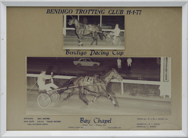 Victorian Harness Racing Heritage Collection at Lord's Raceway Bendigo
Photograph - Framed photo finish, Greg Matthews Photo, Bay Chapel, 11 January 1977
Bay Chapel won the Bendigo Pacing Cup on the 11 January 1977, followed by Purple Para and Gallagher. Bay Chapel owned by Mr & Mrs J Hussey Jnr, was trained by RV Knight, driven by V Knight. Bay Chapel raced from 1973 (2yo) through to 197 (8yo). Career: 23 wins 14 seconds 17 thirds 132 starts. Refer to Identifier 15.035 (Media) for Full Career Performance Record.Two colour photographs, one small one large in a white frame. At the top: Bendigo Trotting Club 11-1-77/ Bendigo Pacing Cup At the bottom: Left corner: Distance 2615 metres/ Mile rate 2.5.3/5 /Track Record / Greg Matthews Photo Centre: Bay Chapel (Chapel Chief - Princess Del) / Purple Para 2nd / Gallagher 3rd Right corner: Owned by- Mr & Mrs J Hussey Jnr/ Trained by RV Knight/ Driven by - V Knightbendigo harness racing club, horses, race, winner, bendigo trotting club, pacing cup, driver, trainer, owner, 1977, bay chapel, rv knight, mr & mrs j hussey jnr, purple para, gallagher, vj knight, vin knight, bob knight -
 Bendigo Military Museum
Pamphlet - PAMPHLET, THANKSGIVING WW2, 9.5.1945
United Services of Thanksgiving and Remembrance on the Occasion of the Achievement of Victory in Europe. HQ 5AUST DIV (AIF) - 9 MAY 45 Two page plain paper pamphlet with typed wording. Shows National Anthem, prayers, hymns, bible reading, 1 minutes silence, Last Post Reveille. Address was by Snr Chaplain R F Stuart - Burnett (C of E).Handwritten in pen: “At Jacquinot Bay, New Britain”pamphlets, thanksgiving, victory, europe -
Victorian Maritime Centre
Vase - Silver
The souvenir metal Vase was purchased sometime during a cruise by an unknown person. It is part of a cruise liner collection by D. Benson and Family over a period of years. D. Benson sold part of the collection to the V.M.C who purchased the remaining part. It is a great source of information to visitors to the V.M.C. At the time of ocean liner holiday cruising, many people purchased these souvenirs to keep or give away as gifts.A silver souvenir vase with logo thereon.Aberdeen and commonwealth line S.S Moreton Baymerchant souvenir, s.s moreton bay -
Port Melbourne Historical & Preservation Society
Plan - Proposed improvements to Hobsons Bay, Melbourne Harbor Trust, The Melbourne Harbor Trust Commissioners - General p`lan shewing proposed harbor improvements 1915, 1915
MHT plan of proposed improvements to Hobson's Bay and areas surrounding and bordering the Yarra. The proposals include piers into the bay near the river and on the north side of the Yarra River.melbourne harbor trust - port of melbourne authority, hobson's bay, town planning - proposals shelved -
Port Melbourne Historical & Preservation Society
Photograph - Pile driver laying foundations for Bay Port falts and new Post Office, former Shell service station site, Bay Street, Port Melbourne, 1999 - 2000
Colour photograph showing pile driver laying foundations for Bay Port flats and the new Post Office on the former Shell service station site, Bay Streetbuilt environment - commercial, built environment - domestic -
Port Melbourne Historical & Preservation Society
Photograph - Bay Street, Sandridge, 1891
Large black & white photograph from 1891 showing Bay Street from Graham Street to Beach Street and Railway Pier, west side of Bay Streetengineering, piers and wharves - station pier, piers and wharves - railway pier, bay street, graham street, beach street -
Port Melbourne Historical & Preservation Society
Photograph - Starch Factory and Bay Street from Port Melbourne Town Hall clocktower, David Thompson, Feb 1994
One of three photos of Bay Street taken from the Town Hall clocktower February 1994 by David Thompson: Bay Street toward south and Starch FactoryDetails on back in inkbuilt environment -
 Bendigo Historical Society Inc.
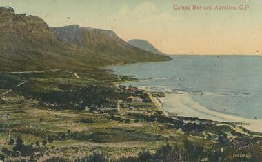
Postcard - Alice McGregor Postcard Collection, 1900 - 1920
Alice McGREGOR Born: 1908; unknown parents. Possibly adopted by the Salter family? Electoral Roll 1936: Highland Terrace Kangaroo Flat. Alice Mary Salter and William Robert Salter living together; presumed to be sister and brother. William Robert Salter was killed in a MVA in Bendigo in 1937 aged 26. In Victoria in 1938, Alice Mary Salter married James Thomas McGregor (born Victoria 1917, died Victoria 1983, buried Fawkner Cemetery) Lived: 1968; 22 Wade Street Golden Square Alice McGregor Died: 1999 aged 91 at Anne Caudle Centre, Bendigo Buried: Kangaroo Flat Cemetery See additional research. Postcard Album of Alice McGregor contained 86 post cards.Postcard Album of Alice McGregor containing 86 postcards. See 1400 Colour photo of Camps Bay and Apostles, C.P., South Africa Small township on the bay. Addressee - Mrs. Gray, Vermont, Vic Sender - E. Branson Stamp dated 9 Dec 1919, Melbourne postcard, collector, alice mcgregor -
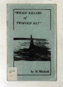 Orbost & District Historical Society
books, Whale Killers of Twofold Bay, circa 1960
Author, Mary Mitchell was the daughter of Charles Wellings early resident of Eden. Charles took many of the early photos of Eden while his brother, Henry, did the research on the Imlay Bros (very early settlers of Orbost) and early Twofold Bay settlers. Mary Wellings married Roy Mitchell of Lower Towamba. In Eden there are streets and a park named for both families.These books record the history of the whaling industry on the south coast of New South Wales.Two copies of a small thin ten page booklet with blue laminated covers. It has black print and a black photo of a whale tail on the front cover.It was written by Mary Mitchell. The book relates the history of whaling at Twofold Bay on the south coast of New South Wales.2116.1 - has a library sticker on the front cove - bottom left hand cornertwofold-bay whaling mitchell-mary welliings -
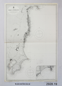 Flagstaff Hill Maritime Museum and Village
Document - Navigation Chart, Tokyo to Sendai Bay
British Admiralty Navigation Chart - Tokyo to Sendai Baywarrnambool, shipwrecked-coast, flagstaff-hill, flagstaff-hill-maritime-museum, maritime-museum, shipwreck-coast, flagstaff-hill-maritime-village, shipwrecked-artefact, british admiralty navigation chart, navigation chart, tokyo to sendai bay -
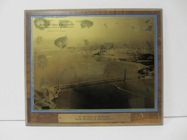 Seaworks Maritime Museum
Plaque, Walter W Cribbins Co
Heavy wooden plaque with image of San Francisco Bay "Port of San Francisco/ "The Pacific Gateway to World Trade"/ Presented by the San Francisco Port Commission" "To the Port of Melbourne from the Port of San Francisco" on reverse side: "PMA 0310" "Distributed by/ Walter W Cribbins Co., Inc./ San Francisco 94105"