Showing 17183 items matching "bay-bridge"
-
 Marysville & District Historical Society
Document (Item) - Transcription of a newspaper article, New Bridge Named After Former Shire Councillor, 1965
A transcription of a newspaper article of the naming of the F.J. Barton Bridge in Marysville in Victoria.A transcription of a newspaper article of the naming of the F.J. Barton Bridge in Marysville in Victoria.marysville, victoria, fj barton, steavenson river, healesville shire council, fred barton, thomas barton, fj barton bridge -
 Orbost & District Historical Society
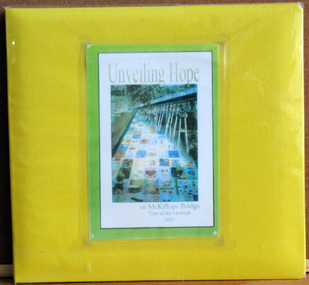
album, Walcott, Judy, Unveiling Hope on McKillops Bridge, 2005
This album was donated to the Orbost & District Historical Society after the death of Judy Walcott, a long-time member. The veiling of McKillops bridge was a 'Year of the Outback' event. The event was organised by Orbost resident, Sr Helen Barnes RSJ. to show solidarity with rural people. The local community transformed the bridge into "a symbol of communal love and hope", when its sides were draped with hundreds of personal messages. McKillop's Bridge, located high in the Snowy Mountains, is named after George McKillop, a pioneering explorer of the area. The bridge is a vital link for isolated farming communities living beyond the Bonang highway.This album is a useful reference tool.A large photo album with a bright yellow cover and 19 plastic sleeves. It contains photographs, newspaper clippings, brochures , maps and an invitation to the veiling of McKillops Bridge on 8th August 2002. It also contains the history of McKillops Bridge.On inside cover - left hand side - "To Marie with Best Wishes from Judy Walcott 8/8/2005"mckillops-bridge album -
 Buninyong & District Historical Society
Photograph - Sepia photograph of original, Leigh Grand Junction Bridge, Leigh Grand Junction Bridge
Bridges, reinforced concrete construction by C.C.P.WilsonSepia photo, Photo of concrete bridge spanning gully, rolling landscape with scattered trees. leigh grand junction bridge, c.c.p. wilson -
 Lakes Entrance Historical Society
Photograph, Caire, Nicholas John, Swing Bridge Sale Victoria c1905, 1905c
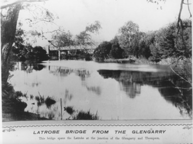
Latrobe Bridge from the Glengarry. This bridge spans the Latrobe at the junction of the Glengarry and the Thompson.Black and white photograph of the Latrobe Bridge,in the closed position, taken from the bank of the Glengarry Latrobe River. Sale Victoriawaterways, bridges, civil engineering -
![Fern Bridge Gully, Black Spur / [by] Nicholas Caire, circa 1876](/media/collectors/550653872162f11fb04854aa/items/577b4c16d0cdd10948c8afab/item-media/577b4c75d0cdd10948c8ebe0/item-fit-380x285.jpg) Kew Historical Society Inc
Kew Historical Society IncPhotograph, Anglo-Australasian Photographic Company, Fern Bridge Gully, Black Spur, c. 1876
Nicholas Caire was born on Guernsey in the Channel Islands in 1837. He arrived in Adelaide with his parents in about 1860. In 1867, following photographic journeys in Gippsland, he opened a studio in Adelaide. From 1870 to 1876 he lived and worked in Talbot in Central Victoria. In 1876 he purchased T. F. Chuck's studios in the Royal Arcade Melbourne. In 1885, following the introduction of dry plate photography, he began a series of landscape series, which were commercially successful. As a photographer, he travelled extensively through Victoria, photographing places few of his contemporaries had previously seen. He died in 1918. Reference: Jack Cato, 'Caire, Nicholas John (1837–1918)', Australian Dictionary of Biography.An original, rare photograph from the series 'Views of Victoria: General Series' by the photographer, Nicholas Caire (1837-1918). The series of 60 photographs that comprise the series was issued c. 1876 and reinforced a neo-Romantic view of the Australian landscape to which a growing nationalist movement would respond. Nicholas Caire was active as a photographer in Australia from 1858 until his death in 1918. His vision of the Australian bush and pioneer life had a counterpart in the works of Henry Lawson and other nationalist poets, authors and painters.Views of Victoria (General Series), No.22 / ‘Fern Bridge Gully, Black Spur’ / Albumen silver photograph mounted on boardInscription on reverse: 'Fern Bridge Gully is situated near the summit of the Black Spur, about two miles from Fernshawe. Here the foliage is exceedingly dense, so much so as to exclude daylight in many places. This stream has derived its name from the fact of the Bridge having been constructed of large massive fern tree. The stream which flows beneath the Bridge is one of the sources of the River Watt.’nicholas caire (1837-1918), australia - landscape photography -
Port Melbourne Historical & Preservation Society
Photograph - Unidentified group outside Chequers Inn Hotel, corner Bay and Bridge Streets, Port Melbourne, 1940s
Unknown group photo outside Chequers Inn Hotel corner Bay and Bridge StsBridge and Chequers on backbuilt environment - commercial, nancy lewis, chequers inn -
 Lakes Entrance Historical Society
Photograph - Mitchell River bridge Bairnsdale Victoria, G A Legg Bairnsdale, 1975 c
Precast piles and beams were manufactured in Bairnsdale. Bridge opened 13 August 1958Black and white enlarged photograph of Mitchell River bridge Bairnsdale Victoriabridges, township, rivers -
 Phillip Island and District Historical Society Inc.
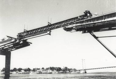
Photograph, Phillip Island Bridge, 1968/9
Final stages of construction of 2nd Bridge (1968/69) connection San Remo with Newhaven. From the Jack Jenner Collection.Close-up of placing of middle Span of Bridge 1968/69.local history, photographs, civil engineering, bridges, phillip island bridges, black & white photograph, jack jenner collection, public construction -
 Federation University Historical Collection
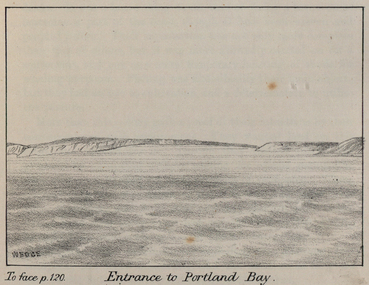
Image - black and white, John Helder Wedge, Entrance to Portland Bay, c1835
From Westgarth's 'Port Phillip Setlement'Drawing of the entrance to Portland Bay, Victoria.potland bay, john helder wedge, portland -
 Federation University Historical Collection
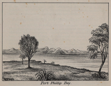
Image - black and white, John Helder Wedge, Port Phillip Bay, c1835
From Westgarth's 'Port Phillip Settlement'.A number of images of Port Phillip Bay. port phillip bay, melbourne, john helder wedge -
 Ballarat Heritage Services
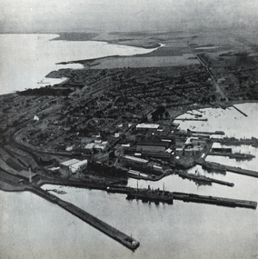
Photograph - Image, Williamstown, on the western side of Hobson's Bay, c1951
Sir Henry Barkly was the Governor of Victoria from 12 December 1856 until 09 September 1963.Williamstown, on the western side of Hobson's Bayvictoria, hobson's bay, williamstown, port -
 Ballarat Heritage Services
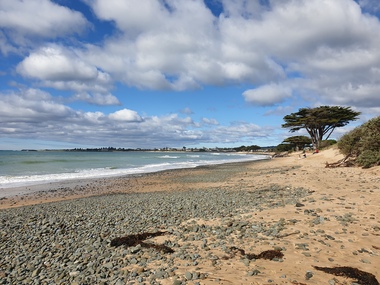
Photograph, Clare Gervasoni, Apollo Bay, 19/09/2020
Colour photograph of the beach at Apollo Bay.apollo bay, beach, coast -
 Ballarat Heritage Services
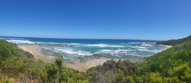
Photograph, Clare Gervasoni, Crayfish Bay, Victoria
Coastal scenes at Crayfish Bay, Victoriacrayfish bay, beach, coast, great ocean road, otways -
 Marysville & District Historical Society
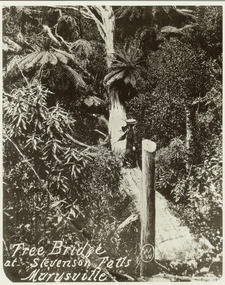
Photograph (item) - Black and white photograph, Tree Bridge at Stevenson Falls Marysville, Unknown
An early black and white photograph of a tree bridge at Steavenson Falls in Marysville in Victoria.An early black and white photograph of a tree bridge at Steavenson Falls in Marysville in Victoria. The Steavenson Falls are named after the Victorian Assistant Commissioner of Roads and Bridges, John Steavenson who arrived in Victoria in the early 1860s.tree bridge, stevenson falls, steavenson falls, waterfalls, marysville, victoria, john steavenson -
 Phillip Island and District Historical Society Inc.
Photograph, Phillip Island Bridge Opening, 1969
Opening of second Bridge in 1969 by Hon. Porter, Minister for Public Works. From the Jack Jenner Collection.Opening of second Bridge 1969 by Minister of Public Works, Hon. Porter.local history, photographs, civil engineering, bridges, opening of 2nd phillip island bridge, black & white photograph, jack jenner collection, phillip island bridges, public construction, hon. porter minister for public works -
 Lakes Entrance Historical Society
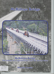
Book, Anne Bell, McKillops Bridge by Rhonda Coates
history of McKillops Bridge over the Snowy River Soft cover book by Rhonda Coates detailing the history McKillops Bridge over the Snowy River bridges, civil engineering, road construction and maintenance, topography -
 Phillip Island and District Historical Society Inc.
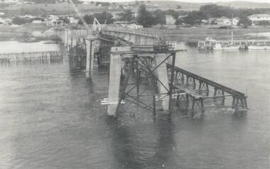
Photograph - Photogragh, Photographs of the opening of the Phillip Island suspension bridge from Newhaven and San Remo
Suspension bridge was opened in 1940. Historical4 small black & white photographs of opening of suspension bridge, showing infrastructure and people and cars attending.Nonefirst phillip island bridge to san remo, phillip island bridge opening -
 Kew Historical Society Inc
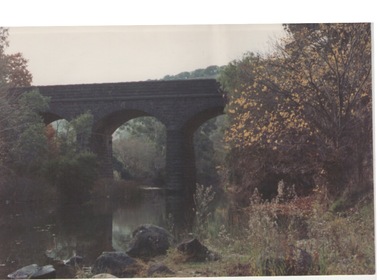
Photograph, Outer Circle Railway Bridge over River Yarra, c.1900
This photograph forms part of the Eric Sibly collection of images and information relating to the Outer Circle Railway which he donated to the Kew Historical Society in 1974. Heritage Victoria Citation (Abridged) "The Chandler Highway Bridge, a 137 metre wrought iron lattice-truss girder bridge with four spans supported on red brick piers with moulded bluestone cappings. The bridge has a cantilevered walkway along the west side. ...The Chandler Highway Bridge crosses the Yarra River and connects Alphington and Kew. It was completed in November 1890 as part of the Outer Circle Railway Line.Black & white photograph of the railway viaduct over Yarra River looking south towards Kew.Reverse: "Pre 1930. Outer Circle Railway Bridge over River Yarra (now Chandler Highway) - note bridge over line on Kew side for Asylum Farm". KH - 56. Kew Historical Society.chandler highway, railway bridges - kew (vic), sir john monash, outer circle railway, river yarra - kew (vic) -
 Chelsea & District Historical Society Inc
Photograph - Patterson River, Rail and Road Bridge, c 1910
The first bridge over the river was built in the early 1880's, prior to this it was a pontoon bridge.Black and white photo of the wooden road bridge (Point Nepean / Nepean Highway), over Patterson River, Carrum near the mouth of the river. patterson river, road bridge, rail bridge, chelsea, transport, patterson river bridge, carrum bridge -
 Greensborough Historical Society
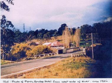
Photograph - Digital image, Plenty Bridge Hotel from west side of river, 1950s
Colour photograph of Plenty Bridge Hotel (Lower Plenty) from west side of river. Also shows bluestone bridge over Plenty River at Lower Plenty.Digital copy of colour photograph.On front of photograph: "15d Plenty Bridge Hotel from west side of river circa 1950s"lower plenty, plenty bridge hotel -
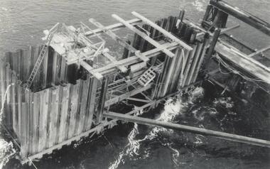 Phillip Island and District Historical Society Inc.
Photograph, Phillip Island Bridge, 1968/9
Construction of 2nd Phillip Island Bridge. 1969. From the Jack Jenner Collection.Scaffolding for concrete works for new Bridge. Top view of empty forming close-up.local history, photographs, civil engineering, bridges, phillip island bridges, black & white photograph, jack jenner collection, public construction -
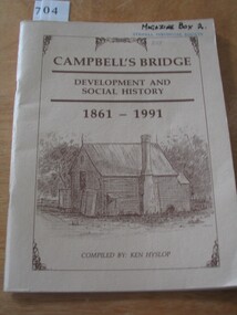 Stawell Historical Society Inc
Book, Ken Hyslop, Campbells Bridge – Development and Social History 1861-1991, 1991
Compiled by Ken Hyslop for the Back to Campbells Bridge in November/ December 1991.Fawn Card Cover brown border enclosing title and sketch of house, and authors nameCampbell's Bridge Development and Social History 1861-1991. Compiled By Ken Hyslop.stawell -
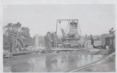 Wodonga & District Historical Society Inc
Photograph - Construction of Wodonga Creek Bridge, 1920
The bridge over Wodonga Creek was opened on Friday 20th October 1922 by the Minister For Public Works Mr Frank. The erection of the bridge was carried out by Mr L Carr, of Brighton. The new concrete bridge was a little more than 500 feet long and consisted of 12 spans. The decking was supported by a number of steel girders, each weighing approximately seven tons. The whole bridge was supported by rows of three cylinders, sunk to a depth of 26ft below the summer water level. The original estimated cost of the structure was £20,000, but with the extras added during construction this amount was exceeded.These photos are significant because the capture the construction of an important bridge between Albury and Wodonga.Three black and white photographs taken during the construction of the new bridge over the Wodonga Creek in 1920.wodonga bridges, wodonga creek -
Marysville & District Historical Society
Flyer (item) - Information Flyer, Artworkz Tourism, Marysville-Historic Timber Tramway Trestle Bridge, Post 2009
A flyer that was produced as a guide to the historic timber tramway trestle bridge near Marysville in Victoria.A flyer that was produced as a guide to the historic timber tramway trestle bridge near Marysville in Victoria. The historic timber tramway trestle bridge is along the Michaeldene Walking Track near Marysville in Victoria. The Michaeldene Trail to Taggerty River Lookout is a 4.3 kilometer lightly trafficked loop trail located near Marysville, Victoria. The track is one of several walking tracks located in and around Marysville in Victoria.timber tramway trestle bridge, marysville, victoria, michaeldene walking track, taggerty river, taggerty river lookout -
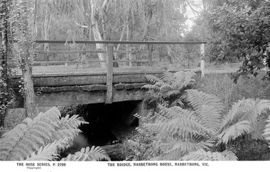 Marysville & District Historical Society
Postcard (Item) - Black and white postcard, Rose Stereograph Company, THE BRIDGE, NARBETHONG HOUSE, NARBETHONG, VIC, 1913-1967
A digital copy of a black and white postcard of a photograph taken of a bridge at Narbethong House in Narbethong.A digital copy of a black and white postcard of a photograph taken of a bridge at Narbethong House in Narbethong. This postcard was produced by The Rose Stereograph Company as a souvenir of Narbethong.narbethong, victoria, australia, postcard, rose series postcard, the rose stereograph company, narbethong house, wooden bridge, p. 2709 -
 Ballarat Heritage Services
Photograph, London Bridge, Great Ocean Road, 01/1990
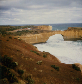
London Bridge, pre 1990 was a double-spanning bridge connected to the mainland. The stack was created over hundreds of years, with the weaker layers toward the base being eroded away by wind and water to form the two bridges. The span closer to the shoreline collapsed unexpectedly on 15 January 1990, leaving two visitors, whilst uninjured, stranded on the outer span before being rescued by helicopter. Two coloured photographs of the London Bridge, on the Great Ocean Road. This photo was taken days before the collapse of the geological feature. The photographer walked across the bridge to the warning of her mother "if you go over there and it collapses you will be stuck. After the collapse it was renamed London Arch. london bridge, great ocean road, london bridge, peterborough, london arch, shipwreck coast, 12 apostles -
 Lorne Historical Society
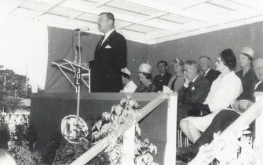
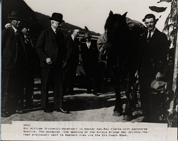
Photograph, Opening of Aireys Bridge 30 December 1932
Photograph of Sir William Irvine (Lt Govenor) at the opening of Airey's BridgePhoto of Sir William Irvine (Lt. Governor) at opening of Airey Bridge. 30th December 1932aireys bridge; sir william irvine, lt govenor, 30.12.1932 -
 Sunbury Family History and Heritage Society Inc.
Photograph, Bulla Bridge
A coloured photograph of the bluestone bridge which spans Deep Creek at Bulla. The photograph is taken facing upstream. The bridge was constructed in 1869 and replaced a ford crossing further downstream. Many bridges in the South West of Victoria were constructed from Bluestone basalt rock because the area is on a large volcanic plain and that rock is in abundance. A coloured photograph of the Bulla Bridge which spans the Deep Creek at Bulla. Photograph 0178 is an identical photograph tho this one.bridges, bulla bridge -
![Township of Lorne, and Loutitt Bay / [by] Nicholas Caire, circa 1876](/media/collectors/550653872162f11fb04854aa/items/5783458ad0cdd1176c6f0c78/item-media/578345eed0cdd1176c6f852b/item-fit-380x285.jpg) Kew Historical Society Inc
Kew Historical Society IncPhotograph, Anglo-Australasian Photographic Company, Township of Lorne, and Loutitt Bay, c. 1876
Nicholas Caire was born on Guernsey in the Channel Islands in 1837. He arrived in Adelaide with his parents in about 1860. In 1867, following photographic journeys in Gippsland, he opened a studio in Adelaide. From 1870 to 1876 he lived and worked in Talbot in Central Victoria. In 1876 he purchased T. F. Chuck's studios in the Royal Arcade Melbourne. In 1885, following the introduction of dry plate photography, he began a series of landscape series, which were commercially successful. As a photographer, he travelled extensively through Victoria, photographing places few of his contemporaries had previously seen. He died in 1918. Reference: Jack Cato, 'Caire, Nicholas John (1837–1918)', Australian Dictionary of Biography.An original, rare photograph from the series 'Views of Victoria: General Series' by the photographer, Nicholas Caire (1837-1918). The 60 photographs that comprise the series were issued c. 1876 and reinforced a neo-Romantic view of the Australian landscape to which a growing nationalist movement would respond. Nicholas Caire was active as a photographer in Australia from 1858 until his death in 1918. His vision of the Australian bush and pioneer life had a counterpart in the works of Henry Lawson and other nationalist poets, authors and painters.‘Township of Lorne, and Loutitt Bay’ : Views of Victoria (General Series) No.60 : Albumen silver photograph | Photo on card with Title and Description on reverse | Mounted 24 x 30 cm; Photo 12 x 17 cm.On Reverse: ‘Loutitt Bay is fast becoming one of the most fashionable Watering-places in Victoria, partly from its easy access by Rail, combined with the magnificent scenery to be found in the Cape Otway Ranges, and the very moderate charges of the houses of accommodation. The large house near the foreground is that of Mr. Mountjoy, which is a Restaurant. Duncan’s Hotel can be seen in the distance, on the brow of the hill.’nicholas caire (1837-1918), lorne (vic), duncan's hotel, loutitt bay, landscape photography - victoria -
 Phillip Island and District Historical Society Inc.
Photograph, Phillip Island Bridge, 1968/9
1969 2nd Phillip Island Bridge under construction. Suspension Bridge demolished early 1970 From the Jack Jenner CollectionConcrete stanchions and scaffolding of new Bridge part built.(opened 1969). Taken from other half looking towards San Remo.local history, photographs, civil engineering, bridges, phillip island bridges, black & white photograph, jack jenner collection, public construction