Showing 260 items
matching beacon
-
 Eltham District Historical Society Inc
Photograph, Peter Pidgeon, Manna Gums, Main Road Bridge, Eltham South, 8 Sep. 2021
The original timber bridge over the Diamond Creek was built around 1840. It was destroyed by floodwaters in October 1923. A temporary bridge was rigged up but further damaged in April 1924. A new concrete bridge was built and opened in October 1926. The bridge decking was widened along with Main Road to Dalton Street by the Road Construction Authority in 1984., The uygraded bridge was opened in October 1984, 78 years after its original opening.These trees are not only significant for the natural environment but also present a navigational beacon back in time as the environmental landscape is developed around them.Born Digitaleltham south, main road bridge, manna gum, diamond creek trail -
 Eltham District Historical Society Inc
Photograph, Peter Pidgeon, Manna Gum, Main Road Bridge, Eltham South, 8 Sep. 2021
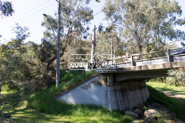
This significant tree located near the Main Road Bridge and Diamond Creek Trail footbridge over the Diamond Creek at Eltham dates back to the early 1900s. The original timber bridge over the Diamond Creek was built around 1840. It was destroyed by floodwaters in October 1923. A temporary bridge was rigged up but further damaged in April 1924. A new concrete bridge was built and opened in October 1926. The bridge decking was widened along with Main Road to Dalton Street by the Road Construction Authority in 1984., The uygraded bridge was opened in October 1984, 78 years after its original opening.These trees are not only significant for the natural environment but also present a navigational beacon back in time as the environmental landscape is developed around them.Born Digitaleltham south, main road bridge, manna gum, significant tree, diamond creek trail -
 Eltham District Historical Society Inc
Photograph, Peter Pidgeon, Manna Gum, Main Road Bridge, Eltham South, 8 Sep. 2021
This significant tree located near the Main Road Bridge and Diamond Creek Trail footbridge over the Diamond Creek at Eltham dates back to around 1870-1880. The original timber bridge over the Diamond Creek was built around 1840. It was destroyed by floodwaters in October 1923. A temporary bridge was rigged up but further damaged in April 1924. A new concrete bridge was built and opened in October 1926. The bridge decking was widened along with Main Road to Dalton Street by the Road Construction Authority in 1984., The uygraded bridge was opened in October 1984, 78 years after its original opening.These trees are not only significant for the natural environment but also present a navigational beacon back in time as the environmental landscape is developed around them.Born Digitaleltham south, main road bridge, manna gum, significant tree, diamond creek trail -
 Eltham District Historical Society Inc
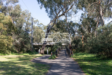
Photograph, Peter Pidgeon, Manna Gum, Main Road Bridge, Eltham South, 8 Sep. 2021
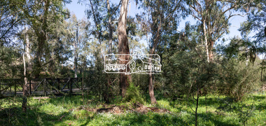
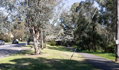
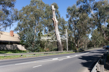
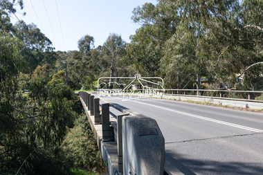
This significant tree located near the Main Road Bridge and Diamond Creek Trail footbridge over the Diamond Creek at Eltham dates back to around 1870-1880. The original timber bridge over the Diamond Creek was built around 1840. It was destroyed by floodwaters in October 1923. A temporary bridge was rigged up but further damaged in April 1924. A new concrete bridge was built and opened in October 1926. The bridge decking was widened along with Main Road to Dalton Street by the Road Construction Authority in 1984., The upgraded bridge was opened in October 1984, 78 years after its original opening.These trees are not only significant for the natural environment but also present a navigational beacon back in time as the environmental landscape is developed around them.Born Digitaleltham south, main road bridge, manna gum, significant tree, diamond creek trail -
 Eltham District Historical Society Inc
Photograph, Peter Pidgeon, Manna Gum, Main Road, Eltham South, 8 Sep. 2021
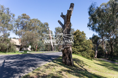
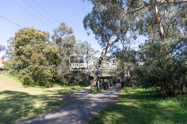
This significant tree located near the Main Road Bridge over the Diamond Creek at Eltham dates back to approximately 1870-1880. Though dead now, its trunk has been left as a wildlife habitat.These trees are not only significant for the natural environment but also present a navigational beacon back in time as the environmental landscape is developed around them.Born Digitaleltham south, main road bridge, manna gum, significant tree -
 Eltham District Historical Society Inc
Photograph, Peter Pidgeon, Manna Gum, Main Road, Eltham South, 8 Sep. 2021
This significant tree located near the Main Road Bridge over the Diamond Creek at Eltham dates back to approximately 1870-1880. Though dead now, its trunk has been left as a wildlife habitat.These trees are not only significant for the natural environment but also present a navigational beacon back in time as the environmental landscape is developed around them.Born Digitaleltham south, main road bridge, manna gum, significant tree -
 Eltham District Historical Society Inc
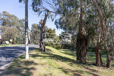
Photograph, Peter Pidgeon, Manna Gum, Main Road Bridge, Eltham South, 8 Sep. 2021
This significant tree located near the Main Road Bridge over the Diamond Creek at Eltham dates back to approximately 1870-1880. Though dead now, its trunk has been left as a wildlife habitat. The original timber bridge over the Diamond Creek was built around 1840. It was destroyed by floodwaters in October 1923. A temporary bridge was rigged up but further damaged in April 1924. A new concrete bridge was built and opened in October 1926. The bridge decking was widened along with Main Road to Dalton Street by the Road Construction Authority in 1984., The uygraded bridge was opened in October 1984, 78 years after its original opening.These trees are not only significant for the natural environment but also present a navigational beacon back in time as the environmental landscape is developed around them.Born Digitaleltham south, main road bridge, manna gum, significant tree -
 Eltham District Historical Society Inc
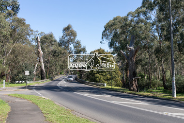
Photograph, Peter Pidgeon, Manna Gum, Main Road Bridge, Eltham South, 8 Sep. 2021
This significant tree located near the Main Road Bridge and Diamond Creek Trail footbridge over the Diamond Creek at Eltham dates back to the early 1900s. The original timber bridge over the Diamond Creek was built around 1840. It was destroyed by floodwaters in October 1923. A temporary bridge was rigged up but further damaged in April 1924. A new concrete bridge was built and opened in October 1926. The bridge decking was widened along with Main Road to Dalton Street by the Road Construction Authority in 1984., The uygraded bridge was opened in October 1984, 78 years after its original opening.These trees are not only significant for the natural environment but also present a navigational beacon back in time as the environmental landscape is developed around them.Born Digitaleltham south, main road bridge, manna gum, significant tree, diamond creek trail -
 Phillip Island and District Historical Society Inc.
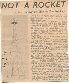
Newspaper Clipping, The Nobbies Navigation Light, 2/7/1964
Collection of Newspaper Clippings from a Scrap Book 1960 - 1973Article about the Navigation Light at The Nobbiesthe nobbies, navigation light, beacon the nobbies, phillip island, jean jamieson -
 Phillip Island and District Historical Society Inc.
Book, WALKER, Donald, Beacons of hope : an early history of Cape Otway and King Island lighthouses, 1981, 1991
Signed by the author. Stamped 'Phillip Island & District Historical Society'.lighthouses, victoria, cape otway, history, tasmania, king island -
 Federation University Historical Collection
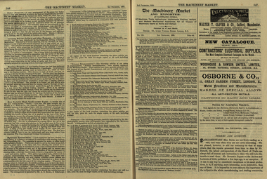
Newspaper, The Machinery Market, 02/12/1889
It's assumed that this journal was read at the Ballarat School of MinesA small illustrated journal with advertisements and pictures. pages 328-356 (and 26 pages of illustrated advertisements). Illustrations include machinery, corn crushers, condensers, chlorination plants. stea, hammers, steam engines, steam pumps, lamps, saw bench, leather belting, casks, barrels, machinery, boiler, cohran and co, birkenhead, stern, cowles syndicate company, electric smelting works, aluminium manufacturing, w t glover and co, rope machine, steam travelling crane, webster wood fibre machine, automatic govenor expansion gear, international exhibition edinburgh, beacon light, air propeller, well boring tools and pumps, cochran and co.'s launch, tug and boat building yard, s.s. jeanette, cochran boiler, cochran and co's boiler shop, stern wheel steamer, s.s. esperanca, cowles syndicate co, milton, w.t. glover & co.'s patent compound rope making machine, bendh drilling machine, steam launch, bicycle, well-boring tools -
Port Melbourne Historical & Preservation Society
Photograph - QEII arriving at Station Pier, Port Melbourne, 2001
Bought from "the Age" by donorColour photograph of QEII arriving at Station Pier. Tugs fore and aft pushing the ship to her berth. Panoramic view of Port Melbourne and city skyline. Copyright "The Age"transport - shipping, piers and wharves - station pier, rms queen elizabeth 2, qe2, beacon cove -
Port Melbourne Historical & Preservation Society
Photograph - Devlopment of Mirvac Housing Project Stage 3, Port Melbourne, Ron Laing, 1997 - 2000
Part of Ron Laing's collection of photographs recording Port Melbourne over a thirteen year period. Donated to the PMH&PS by the photographer.One of sixty four photographs covering the development of Mirvac Housing Project, Stage 3 (BP and Engine Works sites)built environment - domestic, beacon cove, environment, ron laing -
Port Melbourne Historical & Preservation Society
Photograph - Light rail line extenion over Beach Street, Port Melbourne, Ron Laing, c. 1996
Part of Ron Laing's collection of photographs recording Port Melbourne over a thirteen year period. Donated to the PMH&PS by the photographer.Colour photographs of the extension of the light rail line over the new Beach Street at the old train stationtransport - tramways, built environment - domestic, beacon cove, ron laing -
Port Melbourne Historical & Preservation Society
Book, Graham Patterson, "Coastal guide to nature and History Port Phillip Bay", 2013
"Coastal guide to nature and History Port Phillip Bay" Book with coloured photograph of rock and coastline on cover.natural environment - beaches and foreshore, natural environment, conservation, piers and wharves - railway pier, piers and wharves - station pier, piers and wharves - princes pier, coastal, port phillip bay, centenary bridge, beacons, robert harper & co ltd, liardet family -
Port Melbourne Historical & Preservation Society
Domestic object - Lamp, Leading Light, Douglas McKenzie, 1980 - 1989
Doug McKenzie collected these lighthouse replicas which were semi cylindrical and mounted on some substance originally. They have been joined and electrified . He gave this piece to Pat Grainger who kept it at home until he died, then donated it to the PMHPS collection.Electric table lamp base crafted by Doug McKenzie from two wooden replicas representing the Leading Lights, souvenired from the Port Melbourne Town Hall auditorium when it was reconstrcted c 1982. "Lighthouse" base brown with gold "light area.built environment - civic, beacons, handcrafts, doug mckenzie -
Port Melbourne Historical & Preservation Society
Photograph - Breakwater between Station and Princes Piers, Douglas Smallpage, 1970s
The catwalk shown in these photographs was removed after a storm severely damaged it (1970s)Five black and white photographs of the breakwater between Station and Princes Piers and the catwalk to service the outer lead light, 1970sbuilt environment, piers and wharves, beacons -
Port Melbourne Historical & Preservation Society
Photograph - Bay views from Missions to Seamen, Port Melbourne, Pat Grainger, 1988
Bay views from Seamen's Missionbeacons, piers and wharves - station pier, bicentenary -
Port Melbourne Historical & Preservation Society
Map - Navigation Charts, Port Melbourne, Williamstown and River Yarra, 1994
.01 - Navigation chart of Port Melbourne, Williamstown and River Yarra channels 1994. Chart No Aust 154 .02 - Navigation Chart of approaches to Melbourne. Chart No Aust 155 c1986sport - yachting, maritime, beacons -
Port Melbourne Historical & Preservation Society
Album - Boxed Album, Bayside Development, 1985 - 1999
One of three boxed albums containing clippings related to "Bayside" Development 1983 and on, collected by Janet Bolitho and Greg Byrne, indexed by Jill Dawson 2014. Index on paper and disk at 2939.18Notations of publication/date on individual itemstown planning - proposals shelved - bayside, public action campaigns, local government - city of port melbourne, janet bolitho, sandridge city development co ltd, scdc, beacon cove, mirvac -
 Port Melbourne Historical & Preservation Society
Booklet, Commemorating Port's Industrial History and Legacy, Feb 2011
Published to commemorate the anniversary of the 1928 waterfont lockout.Booklet with mauve background and black and white and dark red text. Back cover has map of "historic watersiders Port Melbourne walk"built environment, piers and wharves - princes pier, industrial disputes, allan whittaker, piers and wharves - waterside workers, maritime union of australia, mua, hogan's flat, beacon cove, james laurence murphy, george sangster -
Port Melbourne Historical & Preservation Society
Photograph - Aerial view of 3 liners at Station Pier, Port Melbourne, 14 Feb 2001
Large colour aerial photograph of 3 liners at Station Pier. Siver Cloud - outer East; QE2 - outer West; Regal Princess - inner West. View of Port Melbourne housing and foreshore development. Women's Welcome (or band) Rotunda on left of photo. Also a newspaper copy of the photo. COPYRIGHT RESTRICTEDmaritime, piers and wharves - station pier, transport - shipping, queen elizabeth ii, regal princess, silver cloud, beacon cove, swallow & ariell ltd, band rotunda -
Port Melbourne Historical & Preservation Society
Photograph - Port Melbourne beach area and Port Melbourne Town Hall, Alison Kelly, 1985
Fifty two (52) transparency slides of the Port Melbourne beach area and Port Melbourne Town Hallbeacons, natural environment - beaches and foreshore, built environment - civic, port melbourne town hall -
 Port Melbourne Historical & Preservation Society
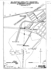
Map, Leading Lights of Port Melbourne Channel, 1926
Proposed arrangement of Leading Lights of mailboat channel at Port Melbourne piersbeacons, melbourne harbor trust - port of melbourne authority, leading lights -
Port Melbourne Historical & Preservation Society
Plan - Plans, Sandridge City Development Corporation, 1989
Book of development plans for Sandridge City Development corporation June 1989local government - city of port melbourne, town planning - proposals shelved - bayside, sandridge city development company pty ltd, scdc, beacon cove, mirvac -
Port Melbourne Historical & Preservation Society
Plan - Port Melbourne Planning Scheme, Bayside Project Area, Development Plan. Comprehensive Development Zone No. 9 (Bayside Project Area). Local Section Port Melbourne Planning Scheme, Apr 1990
Development Plan. Comprehensive Development Zone No. 9 (Bayside Project Area). Local Section Port Melbourne Planning Scheme. 1990. Large white spiral bound folder.town planning - proposals shelved - bayside, local government - city of port melbourne, built environment, sandridge city development co pty ltd, scdc, beacon cove, mirvac -
Port Melbourne Historical & Preservation Society
Archive - File, Port Melbourne Leading Lights, c. 1995
Found in Pat Grainger's archivesFile of photocopies prepared for Angela Wallace in the early days of the City of Port Phillip, as reference for commissioning public art installation re the Leading Lights - - extracts from heritage study done about 1990 ;letter to Angela;piers and wharves, leading lights, arts and entertainment, beacons, angela wallace, leading lights -
Port Melbourne Historical & Preservation Society
Photograph - Restoration of Port Melbourne railway sation as a medical centre, Ron Laing, c. 1996
Part of Ron Laing's collection of photographs recording Port Melbourne over a thirteen year period. Donated to the PMH&PS by the photographer.A colour photograph of the restoration of the Port Melbourne railway station to be used as a medical centretransport - railways, built environment - domestic, beacon cove, ron laing