Showing 287 items
matching bendigo area map
-
 Bendigo Historical Society Inc.
Map - SANDHURST (PART), Circa 1880's
Map: Parish plan sowing an area along Specimen Hill Rd. ( number 211 in Map Cupboard 1)map, bendigo, parish plan, specimen hill rd. sandhurst , bendigo -
 Bendigo Historical Society Inc.
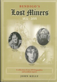
Book - BENDIGO'S LOST MINERS 1852 - 2001, 2008
Bendigo's Lost Miners 1852 - 2001, a collection of over 850 biographies and accident reports with copies of some inquest reports, mine managers reports, applications for graves and other documents with regard to the deaths of men, boys and one woman who were killed in Bendigo's mines from 1852 to 2006. Published by Australian Institute of Genealogical Studies Bendigo area, 381 pages with photographs, illustrations and maps.John Kellybendigo, mining, deaths, bendigo - history - gold mines - bendigo gold miners, mine accidents. -
 Bendigo Historical Society Inc.
Document - MCCOLL, RANKIN AND STANISTREET COLLECTION: CENTRAL NELL GWYNNE, March - April 1943
Document. Manila folder & 4 letters, 1 map The 4 letters pertain to an application by the Commonwealth of Australia to the lands Depart. For sale of an area of 8 acres 0 roods 31 perches now comprising the garden of Fortuna to unlimited depth.McColl, Rankin & Stanistreetorganization, business, central nell gwynne, mccoll, rankin & stanistreet, central nell gwynne gmc, south nell gwynne, gold mining, dept of mines -
 Bendigo Historical Society Inc.
Document - MCCOLL, RANKIN AND STANISTREET COLLECTION: NAPOLEON REEF GOLD MINING CO. N.L, 1938
5 Page Legal Document with map of lease area, 6 land application forms (see attached pdf for details).organization, business, industrial - mining, mccoll rankin & stanistreet, mining, gold mining, napoleon reef -
 Bendigo Historical Society Inc.
Document - MCCOLL, RANKIN AND STANISTREET COLLECTION: NAPOLEON REEF GOLD MINING CO. N.L, 18 Feb 1941
Document: 4 Page legal document with map of lease area issued to William James Moore of Bendigo, Lease No. 11064 Bendigo, Vol. 325 Fol. 35881 County of Bendigo Parish of Sandhurst, 15 year lease from 18th February 1941, in vacinity of Curnow St, Booth St, Maple St and Rowan Sts, Lease by South Napoleon to be allowed to lapse in 1942, signed by Major General Sir Winston Joseph Dugan Governor of Victoria, William James Moore & witnessed by Walsh, Wardens Clerk Bendigo.organization, business, industrial - mining, mccoll rankin & stanistreet, mining, gold mining, napoleon reef -
 Bendigo Historical Society Inc.
Document - MCCOLL, RANKIN AND STANISTREET COLLECTION: NAPOLEON REEF GOLD MINING CO. N.L, 22 August 1950
Document: 5 Page legal document with map of lease area, Lease No. 11273 Bendigo, Vol.331, Fol. 36453, 15 year lease from 12 December 1949, in vicinity of Inglis, Harvey & Curnow Streets, Signed by Dallas Brooks, Gov of Victoria & J.J. Stanistreet, Mine Manager.organization, business, industrial - mining, mccoll rankin & stanistreet, mining, gold mining, napoleon reef -
Bendigo Historical Society Inc.
Map - MINING PLAN ,VICTORIA HILL AREA, No date visible
Map: Large scale plan of an area of the Goldfield, Northward from Barnard Street, covering the Victoria Hill area. Black printing on polycarbonate film. Transparent.map, bendigo, mining plan, mining, gold mines, victoria hill, lines of reef -
Bendigo Historical Society Inc.
Map - BIG 180 SHAFT POSITION, No date visible
Map: Plan showing the location of various shafts in the Victoria Hill area, hand draughted in pencil. Scale 2 Chains to 1 inchmap, bendigo, mining plan, mining , gold mines. victoria hill, big 180 -
Bendigo Historical Society Inc.
Map - BENDIGO, October 1st 1893
... for Selection Map: Plan of the whole County of Bendigo, Showing areas ...Map: Plan of the whole County of Bendigo, Showing areas now available for Selection (number 340 in map cupboard 1)map, bendigo, lands for selection, county of bendigo, areas available for selection -
Bendigo Historical Society Inc.
Map - COUNTY OF RODNEY, No date visible
... Inc. History House 11 Mackenzie Street Bendigo goldfields MAP ...Map: Plan of the whole County of Rodney , showing areas available for selection, October 1st 1893.map, rodney, areas available for slection, county of rodney, areas available for selection -
 Bendigo Historical Society Inc.
Map - LONG GULLY HISTORY GROUP COLLECTION: MAP OF LONG GULLY AREA
map of Long Gjully and California Gully area from Craig Street to Barrell Street. Indicators show location of the mental hygiene Austhority, Agricultural Showgrounds and Recreation Reserve. The boundary between the Borough of Eaglehawk and Bendigo is shown by a dotted line along McGowan Street.eaglehawk, history, street map long gully/california gully. -
 Victorian Aboriginal Corporation for Languages
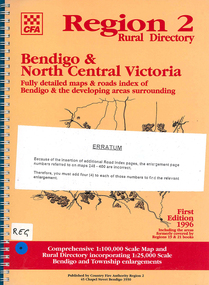
Map, Country Fire Authority, Region 2 rural directory : Bendigo &? North Central Victoria: fully detailed maps &? roads index of Bendigo &? the developing areas surrounding, 1996
... index of Bendigo &? the developing areas surrounding Map Country ...mapsbendigo, loddon, fire protection, victorian regional maps, directories -
 Ballarat Tramway Museum
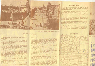
Pamphlet, The Bendigo and District Tourist Association, "Bendigo & District tourist guide", 1972
Folded printed pamphlet, four folds, printing in blue and brown ink on fawn paper, titled "Bendigo & District tourist guide", giving a historical outline of the district history and Bendigo today, along with a map of the important tourist features in the CBD area. On the reverse has a district map showing the location of the various district features. Published by The Bendigo and District Tourist Association in 1972. Three copies held.trams, tramways, bendigo, bendigo trust, map -
 Bendigo Historical Society Inc.
Document - MCCOLL, RANKIN AND STANISTREET COLLECTION: MINING LEASE NO 10173 GARDEN GULLY SHAFT, 9th March, 1934
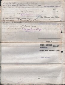
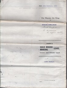
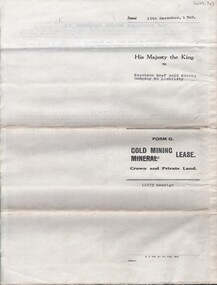
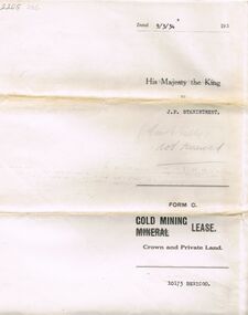
Mining lease 5 page document for lease application 10173, dated 9th March 1934, within area bounded by Don, Barnard Streets up to Mt. Korong Road, area 10 acres. Document signed by John Jepson Stanistreet in the presence of W.A. Kell, Warden's Clerk, Bendigo. Hand coloured plan of lease appended to document, yellow section refers to lease. Marked on map Central Garden Gully shaft. On front of lease ' entered in the Register Book Vol 303 Fol 33698' On back ' His Majesty the King to J.P. Stanistreet (Cent G Gully not renewed written in pencil) Form C Gold Mining Lease Crown and Private Land'gold, mining, garden gully shaft -
 Bendigo Historical Society Inc.
Map - VICTORIA HILL AREA
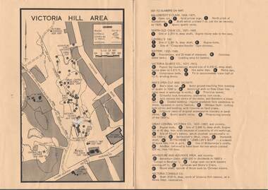
Map of Victoria Hill Area printed on yellow paper. Details of tracks, cuttings, contours (in Metres) and Anticline. Location of mines, open cuts and buildings are shown. Numbers on map are: Ballerstedt's Claim 1 - 5; North Old Chum Co. 6; Lansell's 180, 7,8,11; Battery 9.10.12; Victoria Quartz Co. 13 - 17; Rae's Open Cut and Vicinity 18 - 28, Great Central Victoria Co 29 - 36, Adventure and Advance Area and vicinity 37 - 40 and Victoria Consols Co 41.map, bendigo, victoria hill, victoria hill area, victoria consols, new chum anticline, great central victoria, rae's open cut, w rae's home, victoria quartz, ballerstedt's open cut, lansell's 180, north old chum, central nell gwynne, john brown factory, gold mines hotel, cleopatra needle type chimney, floyd's battery, ballerstedt's 24yd claim, humboldt shaft, wittscheibe's jeweller's shop, luffsman and sterry's claim, victoria hill reserve, mines dept reervation -
 Bendigo Historical Society Inc.
Document - HERITAGE REPORT: FORMER POLICE STATION AND QUARTERS: CALIFORNIA GULLY
Seventeen page Heritage Place Report on the Former California Gully Police Station at 15 Thorpe Street, California Gully. It is the former police station and quarters, former timber stables and timber cottage residence demolished and horse paddock on separate title. Report includes a Statement of Significance, Place History (History of the Area), Policing California Gully Goldfields, History of the Buildings, Chronology of Ownership, Rate Books 1858, - 1867 - 1868, 1895 Borough of Eaglehawk Rates, 1922 Voters Roll, 1952 & 1962 Sands & McDougall Directory Thorpe St California Gully, Comparable Examples, Secondary Sources, Description Conservation Policy Guidelines (Specific), Physical Conditions, Physical Description 1, Map of Early Photo Location, Bendigo Parish Plan circa 1870, Certificate of Title 1950 & 1960. Pge 14 has plans, maps and an aerial photo of 15 Thorpe Street. Page 15 has an aerial photo of 15 Thorpe Street, California Gully with Allotment Size. Page 16 & 17 has photos.heritage, heritage report - former police station and quarters - california gully, city of greater bendigo, wilson & ass, butler, amanda jean, johnson reef shafts no 1 & 2, rose of denmark, princess dagmar, bendigo amalgamated goldfields company, captain frederick standish, royal irish constabulary, e thorpe, campbell, taylor, watson, brown, hosken, mckowne, mcqualter, parker, hicks, eaglehawk municipal council, victorian police force, d bannear, historic mining sites in the sandhurst eaglehawk and raywood mining divisions, department of conservation and natural resources, joshua thorpe, thorpe & co, johnson & co, william thorn, michael thomas, james murdock, edward c brown, francis youlden, gold escort, water police, mounted police, city police (melbourne), geelong police, gold fields police, rural bench constabulary, the people's force, robert haldane, n wild, streets of the borough of eaglehawk, police registration act, william henry mitchell, camp hotel, j o c nieman, j m catarach, g w hosken, margaret hosken nee mckown, majorie alice mcqualter, kellie anne mcqualter, adam joseph doolan, mr hicks, sands & mcdougall, hill george, meeking howard, mcewan frank a, jinks stanley, mccaig mrs eleanor, gordon john l, mcqualter mrs adeline, maher william l, raynor robert, flack john p, whitehead miss a, sang george t, linddsay john p, dyer henry, jackman george a, tibbetts mrs s a, hosken mrs margaret winifred nee mckowne, chaplin frank w, wilson c e, wright george, miller g a, sheyhill basil hugh, marshall r, miles j h, parker w b, barkla w g, nicholls les, cartledge clifford william, cole charles basil, farmers citizens trustees co, bev hanson -
 Bendigo Historical Society Inc.
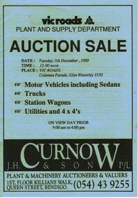
Document - IAN DYETT COLLECTION: AUCTION CATALOGUE - VIC ROADS
Light blue covered auction catalogue with black printing for a sale on 5th December, 1989 at Vic Roads, Glen Waverley. For sale were Motor Vehicles including Sedans, Trucks, Station Wagons, Utilities and 4 x 4's. J. H. Curnow & Son P/L were the auctioneers. Back cover has a map locality and a locality map of the auction area.business, auctioneers, j h curnow & son pty ltd, ian dyett collection - auction catalogue - vic roads plant and supply department, j h curnow & son p/l, bolton bros pty ltd -
 Bendigo Historical Society Inc.
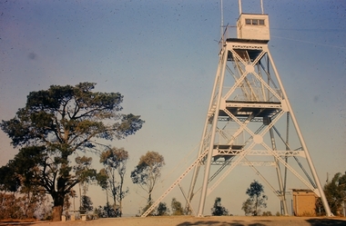
Slide - Peter Ellis Collection, Kaweka Wildflower Reserve, Castlemaine, Lightning Hill Lookout Bendigo, One Tree Hill Lookout Tower Bendigo, Kamarooka Forest Area, c1970-1972
Kaweka Reserve is a a small reserve of approximately 8ha. The land was donated to the Castlemaine City to be a wildflower Reserve. A management committee was formed in 1966. The committee is still managing the park. Vicroads Edition 6: Map 59E2, 628 H4 Location. Turner St, Castlemaine. From the Castlemaine Post Office, drive north (towards Bendigo) and turn right along Turner Street to the park entrance. What to do: walk along some of the tracks through the park follow the nature trail bird watch have a picnic at the picnic tables. RUSH Dam is a basic free camping area sits alongside Rush Dam in the Greater Bendigo National Park, featuring a single picnic table and wood fire barbecue.Peter Ellis Collection: Seventeen slides of Kaweka Wildflower Reserve, Castlemaine, Lightning Hill Lookout Bendigo, One Tree Hill Lookout Tower Bendigo. Also the Rush Dam free camping area at Kamarooka. Also a slide of an unknown group having a meal or day out; perhaps also a working bee. In addition there are two slides of a house - location not specified; and a working bee clearing along a pipeline at Big Hill. Peter was a chemistry lecturer at the Bendigo Institute of technology.history, bendigo, peter ellis collection, whipstick bendigo, bendigo state forests, kaweka wildflower reserve castlemaine, one tree hill lookout bendigo, lightning hill lookout bendigo, kamarooka, rush dam kamarooka, greater bendigo national park -
 Bendigo Historical Society Inc.
Document - PETER ELLIS COLLECTION: A GUIDE FOR DRIVERS ON THE WHIPSTICK TOUR
A Guide for Drivers on the Whipstick Tour. First page gives assembly area, driving in convoy and negotiating water or boggy patches across the road. Amended written at the end of the page. Directions with mileage and items of interest for the tour on Sunday September 9th (no year). A Whipstick Map 1971 showing State Forest, Crown Lands, Uncleared Mallee - Private (shown in different colours) Water Reserve and Roads. Noted are Flora and Fauna - Plants, Birds & Mammals, and areas of State Forest and Southern State Forest with Mallee Scrub area noted. Also State Forest & Crown Lands Total Area and a map scale. The Bendigo Whipstick mentions area, suggestions of where the name Whipstick came from, shrubs and flowers with their flowering times, descriptions of some of them and some information on the Mallee Fowl. The Eucalyptus Oil Industry paragraph mentions the beginnings of the industry. Mentioned are the different uses of oils (perfumery, industrial and medicinal) and the different species of eucalypt used for each and various products. Also notes on the growing, harvesting and refining of eucalyptus. P Ellis at the end of the page. The next two and a half pages mentions reserves, and at the end acknowledgements. Includes a spare copy of 'The Bendigo Whipstick' by P Ellis.bendigo, history, early bendigo, peter ellis collection, a guide for drivers on the whipstick tour, the whipstick 1971 map, shire of marong, shire of east loddon, shire of huntly, borough of eaglehawk, city of bendigo, shire of strathfieldsaye, the bendigo whipstick, eucalyptus oil industry, eaglehawk town hall, lightning hill lookout, eaglehawk rifle range, new moon mines, blue jacket reservoir, maggetti's wine hall, camp hotel (ex), skylark dam, eucalyptus oil production, eucalyptus factory, whipstick eucalyptus farm, ruedin's eucalyptus factory, dutch bowls, governor philip, sir joseph banks, john white, baron von mueller, joseph bosisto, commonwealth government, perfumery oils, industrial oils, medicinal oils, p ellis, dr frith, csiro wildlife division, harley webster, forests commission, vincent serventy, victorian national parks association, bendigo field naturalists club -
 Bendigo Historical Society Inc.
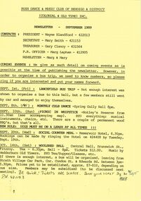
Document - PETER ELLIS COLLECTION: BUSH DANCE AND MUSIC CLUB BENDIGO, September
Three Bush Dance & Music Club of Bendigo & District Newsletters, Sept 1989 (yellow), October 1989 (green) and December 1989 (yellow). Newsletters contain contacts, Coming Events, dance programs and September 1989 edition has a map of how to get to the Notley's Picnic area. Also reports and in the October edition a sketch of how to get to a picnic area in the Wellsford Forest. The December issue has the contacts, Christmas Break-up and next meeting. On the back is the monthly dance dates for 1990.clubs, music, bush dance & music club of bendigo, peter ellis collection, bush dance & music club of bendigo & district, wayne blandford, mary smith, gary clancy, marg lapham, notley's reserve, reservoir hotel, wedderburn old timers, harry mcqueen & friends, lorraine ogilvie, mike jackson, val wilson, barry simpson, peter ellis, victorian folk music club, shirley andrews, john meredith -
 Bendigo Historical Society Inc.
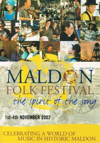
Magazine - PETER ELLIS COLLECTION: MALDON FOLK FESTIVAL
Eight copies of Maldon Folk Festival books for the years 2002, containing a programme alterations loose page; 2003; 2004; 2005; 2006, containing a 2006 Maldon Folk Festival Performers application; 2007; 2008 containing a Maldon Folk Festival Survey form; and 2010, containing a Maldon Folk Festival Survey form. All have colourful front covers with the name and dates printed on them. Also contains features, names of performers, advertisements, programmes and a map of the area. Performers include Emu Creek Bush Band, Wedderburn Old Timers and Peter Ellis.magazine, organization, maldon folk festival, peter ellis collection, emu creek bush band, wedderburn old timers, peter ellis -
 Bendigo Historical Society Inc.
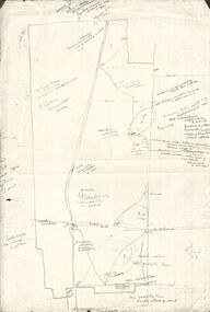
Map - PETER ELLIS COLLECTION: MAP AREA AROUND MITIAMO
Copy of a hand drawn map of an area near Mitiamo with various plants/trees, features and Aboriginal Water Holes drawn in. Also a smaller copy of the top part and two smaller copies of the lower half of the map.map, victoria, rushworth/whroo, peter ellis collection, mitiamo area, aborigine water holes -
 Bendigo Historical Society Inc.
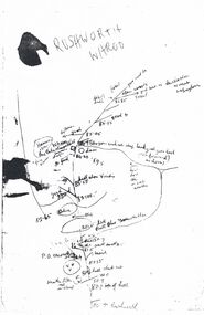
Map - PETER ELLIS COLLECTION: MAP
Five photocopies of drawings of the Rushworth area and three copies of Rushworth-Whroo. All maps have various features and some plants noted. Also mentioned is the Balaclava Hill Open Cut Mine.map, victoria, rushworth/whroo, peter ellis collection, rushworth, whroo, aboriginal water holes, balaclava hill open cut mine -
 Bendigo Historical Society Inc.
Document - MCCOLL, RANKIN AND STANISTREET COLLECTION: SUNDRY REPORTS, 1930's
Manilla Folder containing reports from various mines in Bendigo and surrounding areas. 1. 4 page typewritten report on the Balaclava Hill Mine at Rushworth and some newspaper clippings about the mine with a plan of the underground workings; 2. Page from the Árgus' dated 2nd August 1900 featuring an article on the survey of the Garden line of Reefs; 3. 5 page report with maps on the Tooleen Gold Field; 4. Single page report about an unnamed mining area claimed to be on the southern end of the Deborah line of reef. (this could be the 'Three Jays' mine in Sedgwick. P. Wilkin); 5. Hand written report on the Coronation Mine, 2 miles east of Walhalla.; 6. Hand written report dated 1935, of the Queen Mary mine, St. Arnaud.; 7. 1932 report on the North Neangar lease.; 8 4 page report on the Kings Prize Gold Mining Syndicate.; 9. Description of the plant of the Marong Alluvial Company? Also a guide for marking out leases.; 10. Crushing details (1 page) from the 'Enterprise' Mine South of and adjacent to Perseverence.; 11. 1 page crushing details from Rowe Brothers, Mosquito Mine, Fryerstown.; 12 hand written report mentions Arthur Hatfield, Scarsdale.; 13. Map with lines of reef showing the position of the New Moon Consolidated and the New Moon United shafts.; 14, Large scale map from Harrison/Victoria street to Havilah Road showing the positions of the Carlisle, North Garden and Unity Shafts.gold mining, miners' safety cage, sundry reports, mining. bendigo, rushworth, balaclava hill, garden line of reef, toolleen, coronation mine, walhalla, queen mary mine, st. arnaud. north neangar, kings prize gold mining syndicate, marong, enterprise mine, perseverence, rowe brothers, mosquito mine, fryerstown, arthur hatfield, scarsdale, new moon consolidate, new moon united, carlisle, north garden, unity. -
Bendigo Historical Society Inc.
Booklet - The Bendigo Naturalist
The Bendigo Naturalist (a set of 5). The Journal of the Bendigo Field Naturalist Club. Vol 5 Nos. 1&2, Vol 6 Nos. 1&2, Vo; 7 No. 2 Each booklet illustrated with B&W photos and maps. Featuring articles and reports on flora and fauna subjects of the Bendigo Area. bendigo naturalist, widlife, flora & fauna -
Bendigo Historical Society Inc.
Book - Swiss and Italian Pioneers in Australasia - Research Directory
In the 1850's and 60's many Italian speaking Swiss migrated to the central Victorian region, particularly around the Daylesford/Hepburn/Yandoit area. They were mostly from the Cantons of Ticino and Sth Graibunden on the Swiss/Italian border. The author Clare Gervasoni is a descendant of the wine making Gervasoni family of Yandoit.238-page book. Clear plastic covers. Pale yellow front page with B&W sketches by A.Faldi. Research Directory & Bibliography of Swiss and Italian Pioneers in Australasia 2000. Featuring Family names, Towns of origin and Shipping Compiled by Clare Gervasoni. Includes map of Italy before unification and introduction to the history of Switzerland and Italy 1850. Published by Ballarat Heritage Services, 2000swiss & italian pioneers, family origins -
 Bendigo Historical Society Inc.
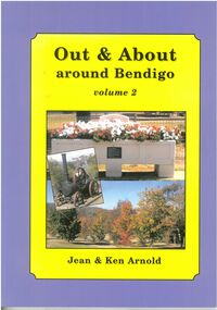
Book - Out and About around Bendigo. Volume 2
BHS CollectionSoft cover book with purple and green colours. Front cover has a photo collage of Bendigo scenes. Back cover has a map of the area covered.plaques, monuments -
 Bendigo Historical Society Inc.
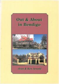
Book - Out & About in Bendigo
Historical markers plaques stones tabulets and photos from an area covering Huntly across to Junortoun to Strathfieldsaye , Mandurang , Big Hill, Maiden Gully and around EaglehawkOut & About in Bendigo - Jean & Ken Arnold Cream outer edge with plum coloured insert with black writing. Front cover Photo Langley Hall Botanical gardens and former Orphanage building Back cover various photos. Pages 80. black and white photos, maps -
 Bendigo Historical Society Inc.
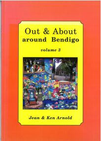
Book - Out & About around Bendigo Volume 3
BHS CollectionOrange outer edge with yellow insert black writing inset of photos Lockwood State School, Maldon photos and Kangaroo Chair Tarnagulla. Back page map of area and various photos. Author Jean and Ken Arnold - 96 Pagesblack and white photos plaques, maps -
 Bendigo Historical Society Inc.
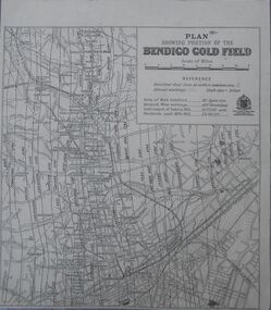
Map - Bendigo Gold Field
Plan showing portion of the Bendigo goldfield. Area of main goldfield: 140 square miles. Deepest mine working: 4593' (Victoria quartz). Gold output of field to 1935: 20,775,000 ounces. Dividends paid 1870-1935: 10,740,000 pounds.map, goldfield, bendigo