Showing 3393 items
matching black horse
-
 Upper Yarra Museum
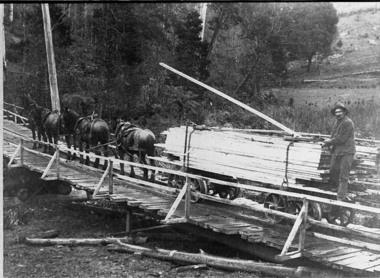
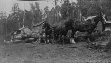
Negative Photographic Reproduction, Arthur Witnish's horse team hauling timber across bridge over Black Sands Creek, 14.2.1983
... timber arthur witnish horse team tramway black sands creek timber ...Black and white negative of Arthur Witnish's horse team hauling timber across bridge on Black Sands Road. Negative Black white. Scanned at 600 dpibridge, timber, arthur witnish, horse team, tramway, black sands creek, timber truck, gladysdale -
 Upper Yarra Museum
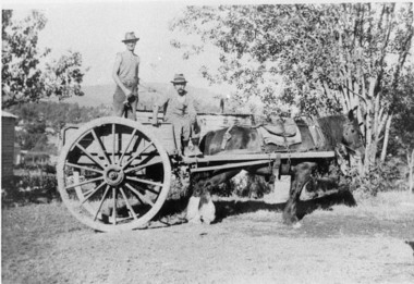
Negative Photographic Reproduction, Charlie Griffiths and Charlie Hort on cart, 14.2.1983
Charlie Griffiths and Charlie Hort on cart Negative Black white. Scanned at 600 dpicharlie griffith charlie hort horse cart -
 Upper Yarra Museum
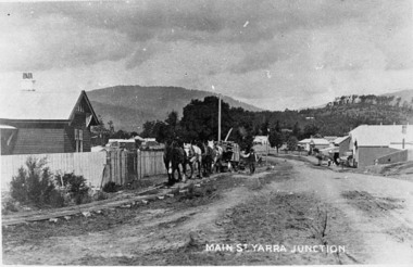
Negative Photographic Reproduction, Main St Yarra Junction
03039 PC Main street Yarra Junction. Team of horses pulling sawn timber on log bogies along the wooden Gilderoy tramline. Upper Yarra Shire 1888-1988 Centenary collection. Black & white Negative, scanned at 600 dpimain st yarra junction station masters house gilderoy tramway -
 Upper Yarra Museum
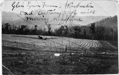
Negative Photographic Reproduction, Glen Lynn Farm, Dad cutting crop with mowing machine, Warburton, 14.9.1983
Glen Lynn Farm, Dad cutting crop with mowing machine, Warburton Negative Black white Scanned at 600 dpiglen lynn farm warburton dad cutting crop with mowing machine horse -
 Upper Yarra Museum
Negative Photographic Reproduction, Working with horses at Mc Crae Creek mill 1945 Beenak
Working with horses at Mc Crae Creek mill 1945 Beenak Black and White negative scanned at 600 dpiworking horses mc crae creek mill beenak 1945 -
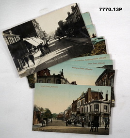 Bendigo Military Museum
Postcard - POSTCARD, ALDERSHOT, UK, Valentine's Series, c 1914 - 1918
R..H. Baron took leave from Herdcott Camp between 4.10.19918 and 8.10.1918 to visit Aldershot. See Catalogue No. 7743 for leave pass details. Relatives lived in the Aldershot area. Part of the 'Robert H. Baron', No.3596 and Cooper Collections. See Catalogue No. 19819 for details of Baron's service.1. Coloured street scene with buildings, groups of people and horse drawn transport. 2. Coloured street scene with buildings, groups of people and horse drawn transport. 3. Coloured street scene with buildings, groups of people. 4. Coloured scene features a canal with boat, tow path, bridge and house. 5. Coloured, Band marching down a street. Spectators lining the road. Church in background. 6. Coloured Group of soldiers in uniform marching along the road. Spectators, church in background. 7. Coloured statue of a man on a horse. Statue located on a hill 8. Coloured scene of gardens surrounded by buildings and a church. Groups of women. 9. Coloured - Large building with a clock tower. 10. Coloured column of uniformed soldiers on horseback. Buildings lining road. Horse drawn transport sharing road. 11. Coloured street scene with red brick building and pedestrians. 12. Coloured Monument with inscription. Buildings in background. 13. Black and wgite street scene. Street lined with buildings. Horse drawn transport. Pedestrians.1. High Street, Aldershot. 2. Wellington Street, Aldershot. 3. Union Street, Aldershot. Handwritten in black ink on back: (Notice how narrow the streets are). 4. Wharf Bridge, Farnborough Road, Aldershot. Handwritten in black ink on back: "I was all over these places with Uncle. I had a good time in Aldershot, Bob. 5. Wellington Avenue (Church Parade), Aldershot. Handwritten in black ink: 'One of the Aldershot bands', R.H. Baron.' 6. Queens Avenue and St. George's Church, Aldershot. Handwritten in black ink on back: 'Soldiers going to church". 7. Wellington Monumental, Aldershot. Handwritten on back in black ink: 'I was right up around this place!' 8. Municipal Gardens, Aldershot. Handwritten on back in black ink: 'This place is very pretty, Bob'. 9. Cambridge Hospital, Aldershot. Handwritten on back in black ink "This is a fine place!". 10. Hospital Hill, Aldershot. 11. Smith Dorrien Home, Aldershot. Handwritten on back in black ink. 'I was all over Aldershot with Uncle. I have saw all these places. Bob.' 12. R.A.M.C. Memorial, Aldershot. 13. Victoria Rd, Aldershot.robert h. baron, cooper collection, aldershot uk, postcards -
 Bendigo Military Museum
Postcard - POSTCARD, FARNHAM, U.K, Valentine's Series, cWW1
1. Florrie is a relative living in Farnham. 2. R.H. Baron married Elsie Keast in 1921. All cards relate to R.H. Baron's visits to Farnham whilst on leave to see Florrie. Part of the 'Robert H. Baron', no.3596 and Cooper Collection. See Catalogue No. 1981P for details of Baron's service.1. Coloured scene of a ruined castle and surrounding gardens. 2. Coloured scene of a garden with building and ruins in background. 3. Coloured photograph of a red brick building with battlement. 4. Coloured street scene with buildings, horse drawn transport and pedestrians. 5. Coloured photograph of the nave of a church looking towards the alter. 6. Coloured street scene with buildings and horse drawn transport. 7. Coloured view across a street to a white walled building with horse drawn transport. 8. Coloured photograph of a church, graveyard in foreground. 9. Black and white photograph of a castle surrounded by trees. 10. Black and white photograph of a forest scene with people standing on a bridge. 11. Black and white photograph of a street scene with buildings, horse drawn transport and people. 12. Black and white photograph of the tower of a church. Graveyard in the foreground. 13. Black and white photograph of a street scene with buildings, horse drawn transport and pedestrians. Castle on the hill in background. 14. Black and white photograph of a street scene with buildings, motor cars and pedestrians. 15. Black and white photograph of a street scene with buildings, motor cars, horse drawn transport and pedestrians. 16. Black and white photograph of a wooded valley. Houses on a hill in the background. 17. Black and white photograph of an avenue of trees. 18. Black and white photograph taken in a park. Three people standing on a bridge over a stream.1. The Keep, Farnham Castle. Handwritten in black ink on back: 'This is one of the pretty places around Farnham. I was all once here with Florrie. Bob' 2. In Castle grounds, Farnham. Handwritten in black ink on back: 'Dear Elsie, these are some places that visit... when I was down at Flories place. Bob xxxxxx' 3. Farnham Castle. 4. West Street, Farnham. 5. Parish Church, Farnham. 6. Castle Street, Farnham. 7. The Church House, Farnham. 8. Parish Church, Farnham. 9. Farnham Castle. 10. Red Hill Hanger, Farnham. Handwritten in black ink on back: 'Letter to R.H. Baron's sister - no date.' 11. South Street, Farnham. Handwritten in black ink on back: 'this part of the place I spent my leave at this is where Florrie is.' 12. Farnham Parish Church. Handwritten in black ink on back: 'Letter to R.H. Baron's mother - dated 24 July 1918.' 13. Castle Street, Farnham. Handwritten in black ink on back. 'I think you will know where this is as I have told you quite a lot about Farnham, it is where Florrie is. I spent my leave here. This is Castle Street and the castle is right on the top of the hill.' 14. Borough, Farnham. Handwritten in black ink on back. ' This is the place where Florrie lives. I spent my last leave their (sic), Bob.' 15. West Street, Farnham. Handwritten in pencil on back. 'Pte R.H. Baron, 57 Battalion, Australian Imperial Forces Abroad.' 16. Lower Bourne Valley, Farnham. Handwritten in black ink on back: 'Partial letter from R.H. Baron to his sweetheart.' 17. The Avenue, Farnham. Handwritten in black ink on back: 'Partial letter from R.H. Baron to his mother.' 18. Recreation Ground, Farnham. Handwritten in black ink on back: 'Letter to Doris from R.H. Baron - no date.' robert h. baron, cooper collection, postcards, farnham uk -
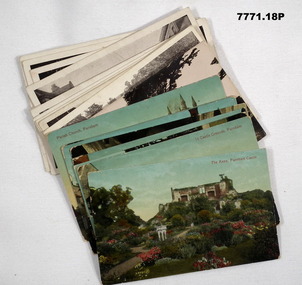
 Bendigo Military Museum
Postcard - POSTCARD, ASH, U.K, F. Frith and Co, c. WW1
Cards collected by R.H. Baron when visiting his Uncle who lived near the village of ASH, UK. c.Nov 1918. Part of the "Robert H. Baron", No. 3596 and Cooper Collections. See Catalogue No. 1981P for details of Baron's service.1. Coloured photograph of a street featuring building including a Post Office. 2. Coloured photograph of a house fronting a gravel road. 3. Sepia toned photograph of a gravel road, vegetation and trees. 4. Sepia toned photograph of a row of houses fronting a gravel road. 5. Sepia toned photograph of a row of houses. Man standing next to a horse and cart. Large pond in foreground. 6. Sepia toned photograph of a row of houses. Man standing next to a horse and cart. Large pond in foreground. 7. Sepia toned photograph of a river with boats moored on bank. Buildings on far side of river. 8. Sepia toned photograph of a row of houses fronting a road. 9. Sepia toned photograph featuring people on a wharf. Row of houses in back ground.1. Pinewood Post Office, Ash. Handwritten in faded black ink on back: 'This is the road Uncle lives in. he live just about opposite the cross (or house in middle) I made on the card, Bob'. 2. York House, Ash. Handwritten in black ink on back: 'Just near my Uncle's place in Ash, Bob.' 3. Fox Hills, Ash. Handwritten in faded black ink on back: 'Letter from R.H. Baron to his brother Freddy - no date.' 4. Ash Common, Victoria Hall, etc. Handwritten in faded black ink on back: ' Of course you will know Ash as you have wrote it bit when writing to Uncle, Bob'. 5. Ash Village & Pond: Handwritten in faded black ink on back: 'This is Ash Village - is about 1 mile from where Uncle lives. Bob.' 6. Ash Village and Pond: Handwritten in faded black ink on back: 'Letter to Elsie from R.H. Baron - no date.' 7. Ash Vale. The Wharf. Handwritten in faded black ink on back: 'Letter to Elsie from R.H. Baron - no date.' 8. Ash Vale. The Wharf. Handwritten in faded black ink on back: 'Partial letter to R.H. Baron's brother - c.Armistice Day. 9. Ash Vale. Handwritten in faded black ink on back: 'Another view of Ash, Bob.'robert h. baron, cooper collection, postcards, ash uk, ww1 -
 Bendigo Military Museum
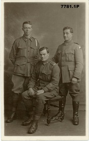
Postcard - POSTCARDS, PHOTOGRAPHIC WW1, Edgar Dawson collection : Battalion comrades
This six-postcard group is the second in a series of records of items in the collection of Edgar Dawson DCM. Dawson was the Regimental Sergeant Major of 57th Battalion, AIF. The 57th had a company of men largely from Bendigo and Eaglehawk. These postcards are from his personal album. Many are annotated in Dawson's hand with explanatory notes on the subject. Refer to Cat No 893 for his service details. Items originally in album cat. no. 207P Service details available through the NAA. Collection of six black and white postcards: 1. Photographic portrait from left William George Saville 4182, Alexander Pollock 3587 57th Btn, and unidentified trooper, possible 4th Light Horse Regiment. 2. Photographic portrait of Light Horse trooper. 3. Photographic portrait of William Tamlyn Curnow, 5078, 57th Btn 4. Photographic portrait of "Jim", 5. Photographic portrait of Septimus Fletcher, 4485, 57th Btn 6. Photographic portrait of Robert Gamble, 4644, 57th Btn 2. Card is addressed to "1904 L.Cpl W.W. Martin, D Cpy 57th Batt". Martin was 2150, KIA 26th September 1917. 3. On front "Sincerely, W. T. Curnow". On verso, "To Hec, from his old pal Curnow Sgt" 'Hec' was Dawson's nickname. 4. On front "Yours sincerely Jim". On verso, card addressed "350 Pte Melen, R. C., 15th Field Ambulance, via Manners St Maryborough Victoria" The 15th Field Ambulance Cpy, supported the 57th and other battalions of the 15th Brigade. 5. On verso "This is an Eaglehawk boy Septimus Fletcher, he came over with me and was with us a long time, but is on Division now" 6. On verso "This is our signal Cpl wearing his military medal for keeping communication at Bullecourt". Gamble won the MM for his actions 13th May 1917.57th battalion, postcards, album dawson dcm, edgar dawson dcm -
 Bendigo Military Museum
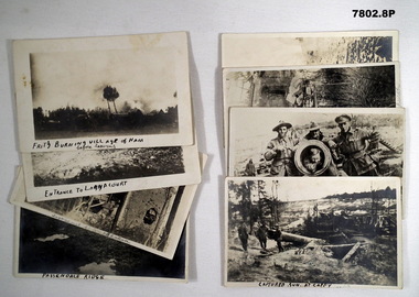
Postcard - POSTCARD - WW1 FRANCE, cWW1
Part of the "Robert H. Baron", No. 3596 and Cooper Collection. See Cat, No. 1981P for details of Baron's service.1. Black and white photograph featuring burning and destroyed buildings. 2. Black and white photograph featuring horses and wagons with uniformed handlers. Ruined buildings in background. 3. Black and white photograph featuring a shell damaged two story building. Splintered trees in foreground. 4. Black and white photograph of a WW1 battlefield. Three waterfilled shell holes in foreground. Soldiers in background on horizon. 5. Black and white photograph of three soldiers in uniform standing next to a ruined cannon. 6. Black and white photograph of three soldiers in uniform standing next to the barrel of a canon. Soldier in uniform inside the mouth of cannon. 7. Black and white photograph of the surrounds of a ruined building. Statue of a human figure surrounded by metal fence in foreground. 8. Black and white photograph of a bomb damaged church. Rubble in foreground.1, Handwritten in black on front bottom and on back in pencil: 'Fritz Burning village of Ham before leaving.' 2. Handwritten in black on front bottom and on back in pencil: 'Entrance to Langacourt.' 3. Handwritten in pencil on front and back: 'Langacourt Chateau.' 4. Handwritten in black ink on front and in pencil on back: 'Passendaele Ridge.' 5. Handwritten in black ink on front and in pencil on back: 'Captured gun at Cappy.' 6. Handwritten in black ink on front and in pencil on back: 'Cappy.' 7. Handwritten in pencil on front and back: 'Bullecourt Church.' 8. Handwritten in pencil on front and back: 'Viller Brettoneaux Church.'robert h. baron, cooper collection, postcard, ww1, france, battlefields -
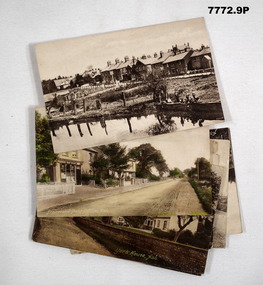
 Bendigo Military Museum
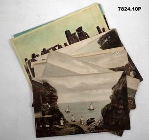
Postcard - POSTCARDS, PHOTOGRAPHIC, VARIOUS U.K, c. WW1
Postcards collected by R.H. Baron while on leave in England during WW1. Part of the "Robert H. Baron" (No. 3596) and Cooper Collections. See Catalogue No. 1981P for details of Baron's service. 1. Coloured coastal scene featuring yachts, beach goers and cliffs. People are standing on a pebbled beach. 2. Coloured coastal scene featuring cliffs and ocean. 3. Coloured coastal scene featuring beach, bathing machines, cliffs and town buildings. 4. Coloured coastal scene featuring beach with boats and town buildings. 5. Sepia toned photograph featuring houses. Stream running in front of house. Footpath between stream and house. 6. Coloured street scene featuring houses fronting a gravel road. 7. Black and white photograph of a street scene featuring buildings, pedestrians and horse drawn transport. 8. Sepia toned photograph of a street scene. Right side lined with houses. Single pedestrian on footpath. 9. Coloured scene featuring standing stones. 10. Coloured photograph of a ruined building overgrown with vegetation.1. Ladram Bay. 2. Ladram Bay. 3. Budleigh Salterton from East. 4. Budleigh Salterton from West. 5. Budleigh Salterton, Cottages at the Granery, 6. Budleigh Salterton, West Terrace. 7. High St. Budleigh Salterton. 8. Budleigh Salterton, Station Road. 9. Stonehenge. 10. Abbey Ruins, Waverley. robert h. baron, cooper collection, postcards, ww1 -
 Bendigo Military Museum
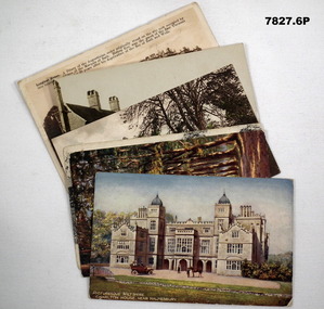
Postcard - POSTCARD, VARIOUS, cWW1
Each postcard features handwritten anecdotes and letters to various people in R.H. Baron's family. Baron was a band member. Part of the "Robert H. Baron" (No. 3596) and Cooper Collections. See Catalogue No. 1981P for details of Baron's service.1. Coloured drawing of a Stately house with motor car, people and a horse in foreground. 2. Coloured drawing of a couple walking through an avenue of trees. 3. Black and white photograph of a church with square tower. 4. Coloured photograph of a mill building and adjacent body of water. 5. Black and white photograph of a row of buildings fronting an unsealed road. 6. Sepia toned photograph of a large stately three storey house.1. Handwritten in black ink on back: 'Letter to Doris written by R.H. Baron - dated 14 July 1918'. Picturesque, Wiltshire, Charlton House, near Malmsbury. 2. Picturesque Wiltshire Avenue, Savernake Forest. Handwritten in black ink on back: 'Letter to R.H. Baron's sisters and brothers.' 3. St. Mary's Church, Motcombe, Dorset. Handwritten in black ink on back: 'We played at a service at this church last Sunday night (1/12/18), Bob xxx' 4. Worplesdan, Rickford Mill, Handwritten in black ink on back: ' Letter to Alf from R.H. Baron.' 5. Crown Inn, etc. Hartley Row. Handwritten in black ink on back. 'Anecdote signed by Bob (R.H. Baron)'. 6. Longleat House. Handwritten in black ink on back; 'We were playing at a dance at this place a few weeks ago. We had a splendid time. It is near Bath, Bob'.robert h. baron, cooper collection, postcards, ww1 -
 Bendigo Military Museum
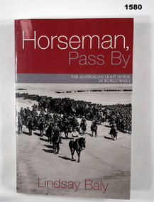
Book - BOOK, WW1, Lindsay Baly, "Horseman, Pass By", 2003
"Horseman, Pass By. The Australian Light Horse in World War 1".Soft cover book. Cover - cardboard, white, red and grey colour print on front, spine and back. Front and back covers illustrated black and white photograph, a mounted division (of soldiers on horseback) march out. 337 pages, cut, plain white paper. Illustrated in black and white photographs, maps and diagrams.books, ww1, light horse -
 Bendigo Military Museum
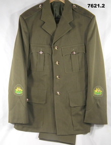
Uniform - JACKET AND TROUSERS, SERVICE DRESS, ARMY, Australian Defence Industries, c.1960's
Uniform issued to "W.O.1 D.M. Field" 313679 - Regimental Sergeant Major.1. Jacket - Khaki colour wool/polyester fabric. Service dress style old plastic buttons, Collar, shoulder epaulettes, four front pockets, top with buttons and two metal press studs on flap, lower button down flap. Sleeve insignia Australian Coat of Arms embroidered on patch, gold, green, blue, red, black and white for W.O.1. Buttons have raised emblem, globe, horse and crown R.A.E.M.E. Green polyester fabric lining with manufacturers label on inside left. 2. Trousers, Khaki colour wool/polyester fabric, service dress style, With fob pocket, two side pockets and one back pocket. Green polyester fabric waist and pocket lining with manufacturers white cotton label inside on back pocket.Manufacturers information on labels - black ink print. 1. "CARBONE APPAREL/ VICTORIA/ 6/ DRY CLEAN ONLY/ RE-PRESS USING IRON AND/ DAMP CLOTH OR MEDIUM/ TO HOT STEAM IRON/ CREASE UPPER HALF OF/ LAPEL ONLY./ SERVICE NO/ NAME" Handwritten blue ink pen "2332/ FIELD" . 2. Print and information on label - illegible.uniform, army, service dress, wo1 d.m. field -
 Bendigo Military Museum
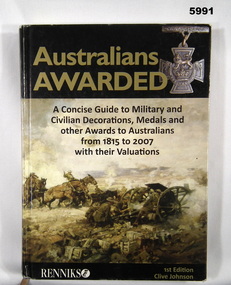
Book - BOOK, REFERENCE, Clive Johnson, " AUSTRALIANS AWARDED", April 2008
"AUSTRALIANS AWARDED" - "A concise guide to Military and/Civilian Decorations, Medals and/ other Awards to Australians/ from 1815 to 2007 with their Valuations" Peter Ball collection, refer Cat No 4704.Hardcover Book Cover - cardboard with adhered paper cover. Gold, black and white print on front. spine and back. Front and spine illustrated in colour - "First Australian Division Artillery going into 3rd Battle of Ypres" by Septimus H Power painting. Artillery guns, horses and soldiers in a battle scene. 359 pages - cut, plain, glossy white paper illustrated in colour - photographs of decorations, medals and awards. Handwritten - owner's name. Handwritten front end paper in blue ink "Peter C Ball" Opposite title page in black ink "Peter C Ball"books, reference guide, history, military warfare -
 Bendigo Military Museum
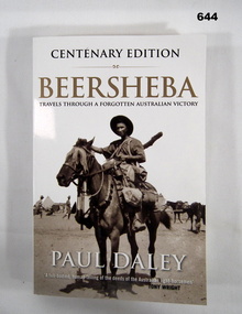
Book - BOOK, WW1, Paul DALEY, Beersheba, First published 2009. This edition published 2017
Information - on front cover - "CENTENARY EDITION/ BEERSHEBA/ TRAVELS THROUGH A FORGOTTEN AUSTRALIAN VICTORY/ PAUL DALEY/. A full-bodied, human telling of the deeds of the AUSTRALIAN LIGHT HORSEMAN/ TONY WRIGHT" On back cover. "It was a glorious triumph of arms for Australian/ Forces, a romantic moment of dash and bravura that/ stood out in the tragedy of World War 1. Yet it barely/ registers in Australia's national consciousness."Soft cover book. Cover - cardboard; black, gold and white print on front, spine and back. White background. Illustrated - front - black and white photograph of a trooper mounted on a horse with full kit. 339 pages, cut, plain, white paper. Illustrated - black and white diagrams of maps and centrefold collection of photographs. Inscription - front end paper.Front end paper - handwritten, black ink - donor's name and date, "Donated by Joy Wellings/ 16-8-2023".books, ww1, beersheba, australian army, light horse regiment. -
 Bendigo Military Museum
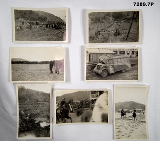
Photograph - PHOTOGRAPHS BCOF
Various photos of Japanese scenes in relation to 1946-52 Occupation Forces. Items in the collection of RICHARD WILLIAM McGILVERY, RAAF. Refer Cat No. 7287P for Service details, photos and awards.Small black and white photos of Japan. 1. People standing around in a field. 2. People standing around inspecting a rice paddy field. 3. Photo of a parade ground with a band marching with some soldiers watching. 4. Picture of a parked bus with roof crushed in, in an urban setting, 5. Portrait photo of machine wreckage (possible a plane) with people in background. 6. Photo of a horse race with people watching. 7. Photo of a horse race with buildings in background.japan occupational forces, photos, richard william mcgilvery -
 Bendigo Military Museum
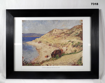
Print - PRINT, FRAMED WW1, Reader's Digest (Australia) Pty Limited, 2015
From Information book; "Reader's Digest/ Gallipoli/ 25th April 1915 - 9th January 1916/ Centenary Commemorative Prints". Collection of 20 prints. Refer Cat No. 7300.Framed print. Print - colour print on paper. Copy of an oil painting with pencil on wood. Depicts a cove with sea, sand and hills. Ruined buildings and structures visible on the beach. Horse eating grass in the foreground. Frame - Black plastic framing with glass front and MDF board backing with adhered black paper.Details below print - in black ink; " GEORGE W LAMBERT (1873-1930) Anzac Cove, 1919" “GEORGE W LAMBERT, unable to enlist in the Australian Imperial Force in London, joined Voluntary Training Corps". Appointed an official Australia War Artist, Australian Imperial Force 1917. framed accessories, prints, ww1, gallipoli, centenary -
 Bendigo Military Museum
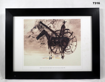
Print - PRINT, FRAMED, WW1, Reader's Digest (Australia) Pty Limited, 2015
From information book - "Reader's Digest/ Gallipoli/ 25th April 1915 - 9th January 1916/ Centenary Commemorative Prints". Collection of 20 prints. Refer Cat No. 7300.Framed print. Print - colour print on paper. COPY OF AN ORIGINAL PAINTING - TEXTILE, DYE, COLOURED CRAYON ON COATED PAPER. DEPICTS IN DARK BROWN COLOURS WITH SMALL ACCENTS OF PALE BLUE, RED AND YELLOW - BELOW HORSE. VISIBLE IN PAINTING IS A SOLDIER, HORSE AND GUN CARRIAGE. Frame - Black plastic framing with glass front and MDF board backing with adhered black paper.Details on print; "SIDNEY NOLAN (1917 - 1992) Gallipoli soldier, horse and gun carriage 1961". Sidney Nolan - embarked on a series of Gallipoli drawings and paintings which he completed over a 20 year period. 252 drawings and painting.framed accessories, prints, ww1, gallipoli, centenary -
 Bendigo Military Museum
Photograph - PHOTOGRAPH - FRAMED WW1, Wayne Eels, C.2008/2009
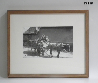
The Grinton Collection. A Civilian with a cartload of possessions. Refer Cat No. 1280 for Jack Grintons service details.Photograph framed. Photograph - black and white photograph on paper, depicting a civilian with a dog, horse and a cartload of possessions. Frame - timber, light varnish finish, Perspex front, cardboard backing."Group 2: Burden of War" "E. A civilian with a cartload of possessions". framed accessories, camera on the somme, 38th bn, agrinton, ww1, civilians -
 Bendigo Military Museum
Photograph - PHOTOGRAPH, FRAMED WW1, Wayne Eels, C.2008/2009
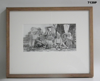
The Grinton Collection. Life after 1919, Grinton relatives. Refer Cat No 1280 for Jack Grintons service details.Photograph - Framed. Photograph - black and white photograph on paper depicting two adults and six children sitting on the ground under a tree. In background, two tree trunks and a horse drawn buggy. Frame - Timber, light varnish finish, Perspex front, cardboard backing."Group 6: Life after 1919". "G. Grinton relatives".framed accessories, camera on the somme, ww1, 38th bn, grinton -
 Bendigo Military Museum
Photograph - PHOTOGRAPH, FRAMED WW1, Wayne Eels, C.2008/2009
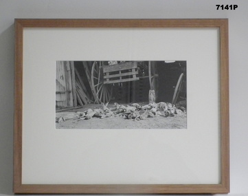
The Grinton Collection. Life after 1919, a rabbit catch. Refer Cat No. 1280 for Jack Grintons service details.Photograph - Framed. Photograph - black and white photograph on paper depicting a collection of culled rabbits on the ground below a backboard and wheels of a horse drawn buggy. Frame - Timber, light varnish finish, Perspex front, cardboard backing."Group 6: Life after 1919". " J. Rabbits." framed accesssories, camera on the somme, ww1, 38th bn, grinton -
 Bendigo Military Museum
Photograph - PHOTOGRAPH, FRAMED WW1, Wayne Eels, C.2008/2009
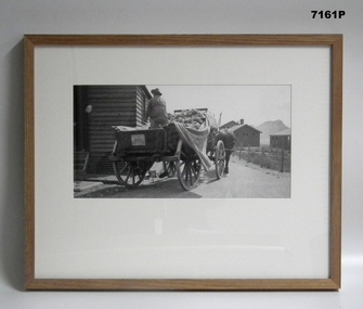
The Grinton Collection. Bread being delivered to Huts. Refer Cat No, 1280 for Jack Grintons service details.Photograph - framed. Photograph - black and white photograph on paper depicts the rear view of a large four-wheel cart with horses. Rear view of soldier and loaf of bread. Small painted insignia on backboard with inscription "40th/A.S.C." Background - roadway and buildings. Frame - timber, light varnish finish, Perspex front, cardboard backing."Group 1: Living behind the Lines". "A. Bread delivery".framed accessories, camera on the somme, ww1, 38th bn, grinton -
 Warrnambool and District Historical Society Inc.
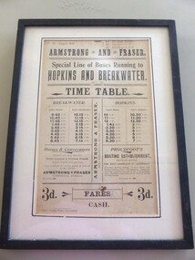
Poster - Armstrong and Fraser timetable, Late 19th Century
This poster is a time table for the coaches operated by Armstrong and Fraser.Their stables were in Liebig Street, Warrnambool next to the Commercial Hotel (The Whalers Hotel today) Armstrong and Fraser commenced business in 1882 and were prominent in Warrnambool at the end of the 19th century and the beginning of the 20th century. The kept as many as 70 horses in their stables and operated a daily timetable for tourists especially those going to the mouth of the Hopkins River and to the breakwater. This poster is of considerable interest as the time table indicates the extensive business of an early coach service in Warrnambool over 100 years ago. The poster comes possibly from the old Warrnambool Museum.This is a sheet of paper containing black printing and handwriting in black ink. It is encased in a black wooden frame with a white cardboard surround and a black border. It has glass protection. There is string and wire at the back for hanging the item . ARMSTRONG* AND * FRASER Special line of buses Running to HOPKINS AND BREAKWATER TIME TABLE (Also other detail re fares, Proudfoot's boating establishment and horses and conveyances) ( Handwriting 87,90, 91 January to March July to Sept. April to June Jany to March) warrnambool, bus timetable, armstrong and fraser -
 Warrnambool and District Historical Society Inc.
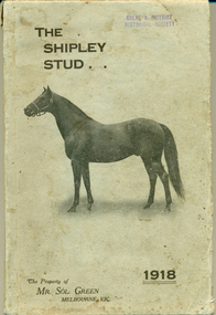
Booklet, The Shipley Stud 1918, 1918
Sol Green came to Australia as a penniless migrant who made his fortune as a bookmaker. He was inducted into the Australian Racing Museum Hall of fame in 2002. He purchased the Shipley stud from George Rolfe about 1905 and set about turning the Ayrford cattle property into a successful horse stud. His horse Comedy King won the Melbourne Cup in 1910 and was retired to stud in 1912. He became one of the top 10 Australian Stallions in the ensuing years. He dispersed his stud at Shipley in 1918 and this catalogue lists the stock sold that day. The property remained in the Green family and continued as a dairy farm with cheese factory and piggery by his son Bob Green. Sol Green was known for his philanthropic gestures extending help where needed on various fronts. Shortly before his death in 1948 he donated 47000 pounds to five Melbourne hospitals.This catalogue has significance firstly on a local level in that Shipley was an important farm in the district and secondly that it was owned by Mr Sol Green who was a person of standing within the racing industry as a bookmaker but also as a stud owner and owner of a Melbourne cup winner in 1910. This catalogue lists the stock which he had established at Shipley in a relatively short period of time.Light grey card cover with horse in brown. The title is in top left corner in brown text with the date 1918 in bottom right. Compilers details on back cover. 164 Pages. It has black and white plates of two horses, Comedy King and White Star* Mallinson Pomborneit 9/1/18. Light paper pasted inside front cover “Colac and District Historical Society, Donor Miss Betty Mallinson 1960. There are purchasers’ names and the purchase price paid, written at the base of each page. warrnambool, allansford, shipley, sol green, comedy king, white star 1918, shipley dispersal sale, shipley stud -
 Warrnambool and District Historical Society Inc.
Book, Cuckoo of the lof raft - Bessie Marchant, Early 1930s
This book was given in 1941 as a prize to Shirley MacDonald from the South Warrnambool Sunday School. This Sunday School was operated by the South Warrnambool Presbyterian Church and existed from 1902 to 2004. The church was in MacDonald Street which was named after John MacDonald, an early teacher and auctioneer in Warrnambool but no details have been found on Shirley MacDonald. This book is of interest as a memento from the South Warrnambool Sunday School and as an example of the type of book given as prizes to young girls in Warrnambool during World War Two. This is a hard cover book of 256 pages. The cover is red with black lettering and the there is a dust cover partly pasted onto the hard cover. The dust cover is multi-coloured with an image of a river scene (man in trouble in the water with a woman trying to help him) on the front and a horse and rider on the spine. The lettering on the dust cover is in yellow and dark blue tonings. The book has become detached from the pages at the back. The inscription is handwritten in blue ink on a printed book plate pasted on to the inside front cover. There is a black and white full page illustration at the front of the book ‘Xmas 1941 Awarded to Shirley MacDonald, Sth Warrnambool Sunday School’ south warrnambool sunday school, shirley macdonald, history of warrnambool -
 Warrnambool and District Historical Society Inc.
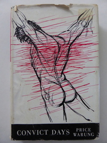
Book, Convict Days, 1960
This book contains selections of the convict stories written by Price Warung, 1864-1911(real name William Astley). He was a journalist and writer who worked for a great number of newspapers throughout Australia and began an important association with the Sydney ‘Bulletin’ in 1890. In this period he write the powerful works for which he is best known, ‘Convict Days’, a series of four volumes of stories about Australia’s convict system. The major theme of these writings is the sordid nature of the convict system. Astley became heavily involved in the Federation campaign, firstly as the Secretary of the Bathurst Federal League and then as the organizing Secretary of the 1896 Bathurst Convention. This Convention is considered by historians to have given the Federation campaign a new and vigorous vitality. In 1898 Astley wrote most of the official articles publishing the ‘Yes’ case for the Federation referendum. In 1883 Astley was in Warrnambool, working as a journalist for the Warrnambool Standard newspaper and examples of his journalism can be found in the papers of this time. He wrote lengthy reports in a free-flowing and attractive but verbose style. His two articles on the well-known horse stud and hop farm called ‘Bryan O’Lynn’ appeared in the Standard in October 1884. This book is of considerable interest as it was written by Price Warung (William Astley). Not only is he of importance in Australia’ history but also he has his place in Warrnambool’s history as a journalist for the Warrnambool Standard in the 1880s. This is a hard cover book of 206 pages. The cover is grey with pink lettering on the spine. The dust cover is white with a black, white and red sketch of a convict on the front and a black and white photograph of the author and his biography on the back cover. The book contains an Introduction and thirteen stories by Price Warung. The dust cover is a little stained and torn. price warung (william astley), warrnambool standard, history of warrnambool -
 Kiewa Valley Historical Society
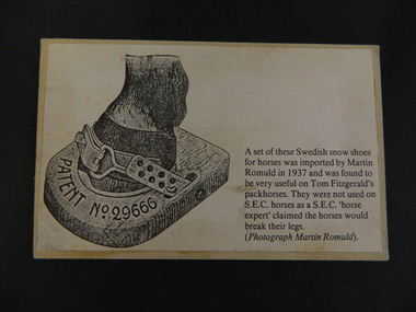
Card - Swedish Snow Shoes for Horses
Swedish snow shoes for horses were imported by Martin Romuld in 1937. They were used by Tom Fitzgerald's packhorses but not on the State Electricity Commission of Victoria's horses as a S.E.C.V. 'horse expert' claimed the horses would break their legs.Tom Fitzgerald lived on the Omeo Highway near Shannonvale and brought cattle up to the Bogong High Plains. He would have travelled in the snow during the year visiting his hut and maintaining his equipment. The S.E.C.V. worked on the Bogong High Plains all year round during the construction of the Kiewa Hydro Electric Scheme. Copy of a black and white photo glued onto cardboard showing a "Swedish snow shoe for horses" followed by further information re their uses on the Bogong High Plains. On the back stamped in blue 'Rescent'swedish snow shoes; horses; bogong high plains -
 Kiewa Valley Historical Society
Photo - Bogong Township, March 1944
In 1940 Field Headquarters for the Kiewa Scheme were established at Bogong with office, workshop facilities and accommodation for workmen, staff and some families constructed. (There had been a 'tent camp' on this site in 1939 but was destroyed by bushfires) Construction of accommodation continued until 1947. A total of 40 houses plus a hostel for single staff, post office, police station, medical centre and primary school all with water and sewerage and electricity supply. The staff hostel was known as Kiewa House and is now occupied by the Education Department. Lake Guy was named after Mr. L.T. Guy who was the Resident Engineer in charge of construction work and associated activities on the Kiewa area. He held this position from 1939 to November 1946 when he was transferred to Head Office. The Bogong Township was developed firstly as an accommodation centre (base camp) for construction workers employed under the Kiewa Hydroelectric Scheme. Due to the influx of European workers into the Township the beautification of the immediate surrounds (gardens etc.) had a distinct European flavour. This environment has been very beneficial for tourism in later years. At the completion of the scheme, in the 1960's, the village was opened to public/tourism use. Strict environmental control has not allowed for any extensive redevelopment in tourist accommodation and basically restricted it to the accommodation initially built for the construction workers. Activities such a bike riding, snow skiing, restricted horse riding and bush walking on the Alpine plains and mountains are now a viable part of the Kiewa Valley Tourist Industry. The lake is one of the many water storage reservoirs used to supply the power stations their main power to run the huge turbines generating the final product, electricityBlack and white photograph of Bogong Township taken March 1944Handwritten on the back of photo - Township March '44bogong village, secv -
 Kiewa Valley Historical Society
Postcard - Lake Guy and Bogong Village
In 1940 Field Headquarters for the Kiewa Scheme were established at Bogong with office, workshop facilities and accommodation for workmen, staff and some families constructed. (There had been a 'tent camp' on this site in 1939 but was destroyed by bushfires) Construction of accommodation continued until 1947. A total of 40 houses plus a hostel for single staff, post office, police station, medical centre and primary school all with water and sewerage and electricity supply. The staff hostel was known as Kiewa House and is now occupied by the Education Department. Lake Guy was named after Mr. L.T. Guy who was the Resident Engineer in charge of construction work and associated activities on the Kiewa area. He held this position from 1939 to November 1946 when he was transferred to Head Office. The Bogong Township was developed firstly as an accommodation centre (base camp) for construction workers employed under the Kiewa Hydroelectric Scheme. Due to the influx of European workers into the Township the beautification of the immediate surrounds (gardens etc.) had a distinct European flavour. This environment has been very beneficial for tourism in later years. At the completion of the scheme, in the 1960's, the village was opened to public/tourism use. Strict environmental control has not allowed for any extensive redevelopment in tourist accommodation and basically restricted it to the accommodation initially built for the construction workers. Activities such a bike riding, snow skiing, restricted horse riding and bush walking on the Alpine plains and mountains are now a viable part of the Kiewa Valley Tourist Industry. The lake is one of the many water storage reservoirs used to supply the power stations their main power to run the huge turbines generating the final product, electricityBlack and white photographic postcard of Lake Guy and Bogong Village. Kiewa Hydro electric Project (showing Junction Dam in front)Handwritten on the back of postcard ' Like most of our camps, this looks like something from the Canadian Rockies' Stamped on the back - Valentine's Post Card A genuine photographlake guy, bogong village, secv