Showing 3583 items
matching black lake
-
 Ringwood and District Historical Society
Photograph, Ringwood black and white photographs
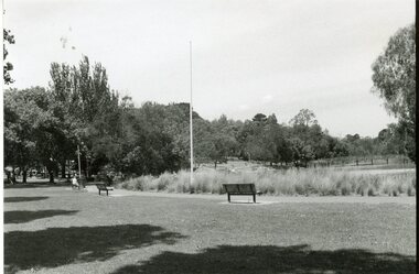
... Road Ringwood North melbourne Ringwood Lake viewed from North ...Black and white photographRingwood Lake viewed from North -
 Ringwood and District Historical Society
Photograph, Ringwood black and white photographs
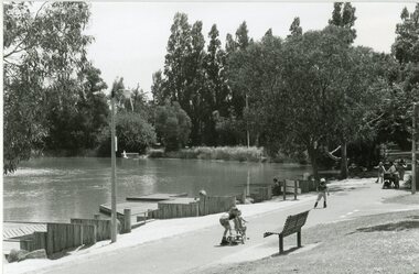
... Road Ringwood North melbourne Ringwood Lake viewed from East ...Black and white photographRingwood Lake viewed from East -
 Ringwood and District Historical Society
Photograph, Maroondah Highway East, Ringwood- 1870. Sandy Creek, now Ringwood Lake
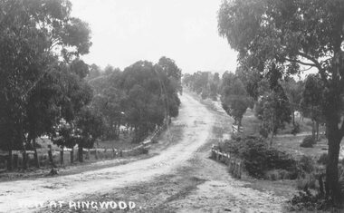
3 photographs (2 large black and white, 2 small- 1 black and white, 1 sepia) Written on all photographs, "View at Ringwood" Typed below large photograph: "Main St looking east. Right hand side of gully now Ringwood Lake. Written on back of sepia print: "1870, Sandy Creek now Ringwood Lake" -
 Ringwood and District Historical Society
Photograph, Maroondah Highway East, Ringwood- 1900. Sandy Creek Bridge, Maroondah Hwy
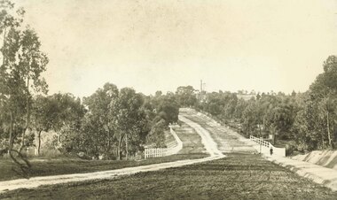
3 photographs ( 2 large black and white, 1 small sepia)Written on all copies: "New Sandy Creek Bridge". Typed below large photograph: "Maroondah Highway Ringwood looking east. To right of bridge is now Ringwood Lake. Mount Dandenong Road turnoff to right at top of rise with antimony mine in background - 1900". -
 Ringwood and District Historical Society
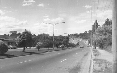
Photograph, Maroondah Highway East, Ringwood in 1973. Eastward view along Maroondah Highway towards Mount Dandenong Road
Black and white photographTyped on back of photograph: "Maroondah Highway by the lake. Looking east towards Mt. Dandenong Rd. - 1973". Ringwood Lake is on the right hand side of the highway. -
 Ringwood and District Historical Society
Photograph, Maroondah Highway East, Ringwood- 963. Excavations for Ringwood Lake overflow
... , "Excavations for Ringwood Lake overflow- 1963." Black and white ...Black and white photograph (2 copies- 1 large, 1 smaller)Written on rear of backing sheet, "Excavations for Ringwood Lake overflow- 1963." -
 Ringwood and District Historical Society
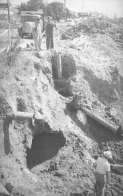
Photograph, Maroondah Highway East, Ringwood. Excavations for Ringwood Lake overflow, 1963
... : "Ringwood Lake overflow pipe (under Maroondah Highway) - 1963 ...Black and white photograph (3 copies- 2 large, 1 small)Written below one photograph: "Ringwood Lake overflow pipe (under Maroondah Highway) - 1963". Typed below a similar image: "Overflow from Ringwood Lake- 1963." -
 Ringwood and District Historical Society
Photograph, Maroondah Highway East, Ringwood- 1963. Excavations for Ringwood Lake overflow
Black and white photograph (2 copies- 1 large, 1 smaller)Typed on rear of backing sheet of large photograph: "Ringwood lake overflow pipe. (Passing under Maroondah Highway). 1963. -
 Ringwood and District Historical Society
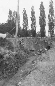
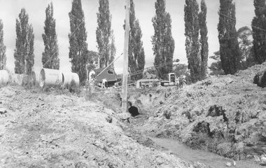
Photograph, Ringwood Lake Overflow Pipe
Black and white photograph of drainage works. Poplars in the background. Equipment and men on roadway above open pipe.Typed below photograph, "Ringwood Lake overflow pipe (Passing under Maroondah Highway) 1963". -
 Ringwood and District Historical Society
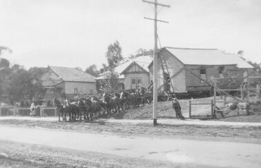
Photograph, Moving the Ringwood Methodist Church from its Maroondah Hwy position near lake - 1916
Black and white photograph of braced wooden building with team of draught horses in front.Written on backing sheet, "Ringwood Methodist Church being moved from Whitehorse Rd. position near lake to position opposite station". A small photograph inserted in sleeve also reads, "Moving Presby. Ch. 1928 (from Whitehorse. Rd. to Adelaide St.)" -
 Ringwood and District Historical Society
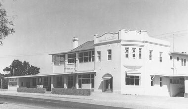
Photograph, Club Hotel, Mount Dandenong Road, East Ringwood in February 1960
Black and white photographs of Club Hotel February 1960 (1 original, three copies). The hotel has a long association with the Reddish family, thus given the name of "Daisy's Hotel". Included 2 copies of the photograph. Ryman Healthcare bought the site in 2019, including the garden supply business next door, making up a 2.2ha area. The proposal was for a $220 million retirement village to be built. The location is next to Ringwood Lake with the old hotel being knocked down in the early 2020s. -
 Ringwood and District Historical Society
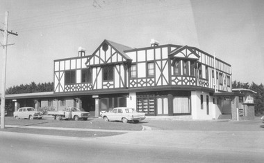
Photograph, Club Hotel, Mount Dandenong Road, Ringwood East in June 1971
Black and white photographs of Tudor style two-storey building (2 originals, 1 copy). The hotel has a long association with the Reddish family, thus given the name of "Daisy's Hotel". Included 2 copies of the photograph. Ryman Healthcare bought the site in 2019, including the garden supply business next door, making up a 2.2ha area. The proposal was for a $220 million retirement village to be built. The location is next to Ringwood Lake with the old hotel being knocked down in the early 2020s. Was H9 in old numbering system.Club Hotel June 1971 -
 Orbost & District Historical Society
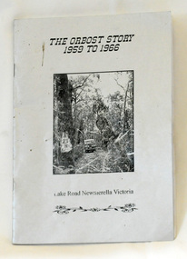
book, Johnson, Brenda, The Orbost Story 1959 to 1966, after 2000
This story was written by Brenda Johnson and details her time in Orbost from 1959 -1966 settling on land at Lake Road in Newmerella.This book is a useful and interesting reference tool on life in Newmerella in the mid 20th century.A thin stapled paperback book of 31 pp. It is titled "The Orbost Story 1959 to 1966 Lake Road Newmerella Victoria". The cover is shiny silver with black print. In the centre is a black/white photograph of the block with numbers ( 2 3 ?) carved into a tree. There is a Land Rover in the background.Stapled inside back cover - "Bob Johnson" with telephone details and email address.newmerella-history johnson-brenda rural farming -
 Orbost & District Historical Society
book, James Yeates & Sons (Printing) Pty Ltd, The Silk Jetties of the Mitchell river, 1972
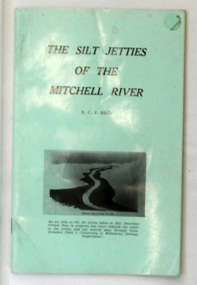
This booklet was the first of a series of scientific and historical studies of Gippsland to be published by the Bairnsdale Advertiser. The author, Eric Charles Frederick Bird was Principal Fellow, Department of Geography, University of Melbourne, Australia. The Mitchell River silt jetties are an unusually long, thin landform located in the Gippsland Lakes region. They have been formed over millions of years by sediment deposition from the Mitchell River during periods of low water flow and subsequent wash-through during periods of high water flow. The long narrow banks of silt extend more than eight kilometres east into Lake King. This item is a useful reference for the silt jetties of the Mitchell River.A 32 pp book with alight green cover. The title is in black print, " The Silk Jetties of the Mitchell River" and underneath the title there is a b/w photograph of the Mitchell River and silt jetties taken from above in 1931. It was written by E. C. F. Bird.silt-jetties mitchell-river paynesville bird-e.c.f. -
 Marysville & District Historical Society
Postcard (item) - Colour photographs, Nucolorvue Productions, A Souvenir of Beautiful Marysville-12 Specially Selected Views in Full Colour, 1950's
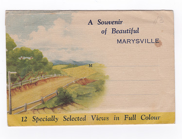
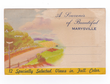
An envelope of 12 colour photographs of attractions in and around Marysville in Victoria.An envelope of 12 colour photographs of attractions in and around Marysville in Victoria. These photographs were produced by Nucolorvue Productions in Mentone, Victoria.A Souvenir of Beautiful MARYSVILLE 12 Specially Selected Views in Full Colour Marysville, Victoria, Australia Marysville, 60 miles from Melbourne, is one of nature's/ lovely beauty spots. The invigorating mountain air helps the/ visitor to enjoy the many delightful walks amongst the tall/ timber, or through the fern glades. Apart from many excellent walking trips, Marysville district/ offers ample scope for car trips to the nearby Cumberland Forest,/ Buxton, Narbethong, or the Taggerty Valley. Skiers find Lake Mountain an attraction in the winter, whilst/ the hiker finds ample for his needs in the numerous mountain/ areas. Huge Eucalypt trees, revealing their ramrod straightness up/ to 300 feet in height, are a fitting background to the many/ beautiful creeks and waterfalls. PUBLISHED BY NUCOLORVUE PRODUCTIONS, MENTONE, VICTORIA.nicholl's lookout (image 1), eildon weir (image 2), road to lake mountain (image 3), foot of steavenson falls (image 4), steavenson falls (image 5), bush scene near marysville (image 6), bush track marysville (image 7), bridge and chalet and crossways marysville (image 8), log cabin at marysville (image 9), black spur (image 10), taggerty river (image 11), highest known hardwood tree (image 12), marysville, victoria, nucolorvue productions, postcard, souvenir -
 Marysville & District Historical Society
Postcard (item) - Colour photographs, Nucolorvue Productions, A Souvenir of Beautiful Marysville-12 Specially Selected Views in Full Colour, Unknown
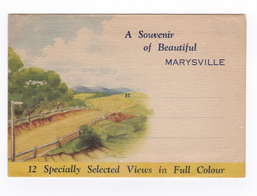
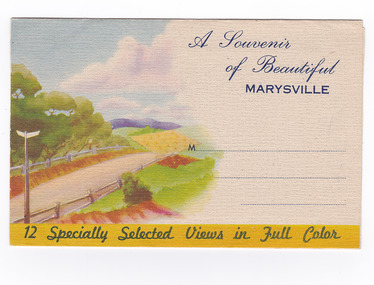
An envelope of 12 colour photographs of attractions in and around Marysville in Victoria.An envelope of 12 colour photographs of attractions in and around Marysville in Victoria. These photographs were produced by Nucolorvue Productions in Mentone, Victoria.A Souvenir of Beautiful MARYSVILLE 12 Specially Selected Views in Full Colour Marysville, Victoria, Australia Marysville, 60 miles from Melbourne, is one of nature's/ lovely beauty spots. The invigorating mountain air helps the/ visitor to enjoy the many delightful walks amongst the tall/ timber, or through the fern glades. Apart from many excellent walking trips, Marysville district/ offers ample scope for car trips to the nearby Cumberland Forest,/ Buxton, Narbethong, or the Taggerty Valley. Skiers find Lake Mountain an attraction in the winter, whilst/ the hiker finds ample for his needs in the numerous mountain/ areas. Huge Eucalypt trees, revealing their ramrod straightness up/ to 300 feet in height, are a fitting background to the many/ beautiful creeks and waterfalls. PUBLISHED BY NUCOLORVUE PRODUCTIONS, MENTONE, VICTORIA.nicholl's lookout (image 1), eildon weir (image 2), road to lake mountain (image 3), foot of steavenson falls (image 4), steavenson falls (image 5), bush scene near marysville (image 6), bush track marysville (image 7), bridge and chalet and crossways marysville (image 8), log cabin at marysville (image 9), black spur (image 10), taggerty river (image 11), highest known hardwood tree (image 12), marysville, victoria, nucolorvue productions, postcard, souvenir -
 Marysville & District Historical Society
Postcard (item) - Colour postcard, Graphic Print Postcards, Marysville, Vic, 2004
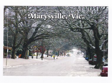
A colour photograph of a snow covered Murchison Street in Marysville in Victoria.A colour photograph of a snow covered Murchison Street in Marysville in Victoria. This photograph was taken in 2004 before the 2009 Black Saturday bushfires that destroyed most of the businesses in the main street.Marysville's main street covered with a light layer of snow. Marysville is a small country town in Victoria, just 10/ minutes from Lake Mountain, one of Australia's best/ Cross Country Skiing Resorts. Graphic in Print/ Postcards Place/ Stamp/ Here Graphic in Print/ Country Towns Collection/ Classic 2/ c 2004/ Ph: (03) 5966 8523 Fax: (03) 5966 8458 Mob: 418 593 534marysville, victoria, murchison street, snow, postcard, souvenir, graphic in print, country town collection -
 Marysville & District Historical Society
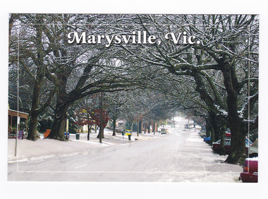
Postcard (item) - Colour postcard, Graphic Print Postcards, Marysville, Vic, 2004
A colour photograph of a snow covered Murchison Street in Marysville in Victoria.A colour photograph of a snow covered Murchison Street in Marysville in Victoria. This photograph was taken in 2004 before the 2009 Black Saturday bushfires that destroyed most of the businesses in the main street.Marysville's main street covered with a light layer of snow. Marysville is a small country town in Victoria, just 10/ minutes from Lake Mountain, one of Australia's best/ Cross Country Skiing Resorts. Graphic in Print/ Postcards Place/ Stamp/ Here Graphic in Print/ Country Towns Collection/ Classic 2/ c 2004/ Ph: (03) 5966 8523 Fax: (03) 5966 8458 Mob: 418 593 534marysville, victoria, murchison street, snow, postcard, souvenir, graphic in print, country town collection -
 Marysville & District Historical Society
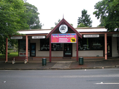
Photograph (Item) - Colour photograph, Unknown
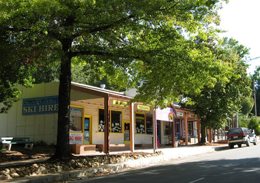
... hire lake mountain 2009 black saturday bushfires A digital copy ...A digital copy of a colour photograph of Cross Country Ski Hire in Marysville in Victoria.A digital copy of a colour photograph of Cross Country Ski Hire in Marysville in Victoria. This building, along with most of the town of Marysville, was destroyed in the 2009 Black Saturday bushfires.marysville, victoria, cross country ski hire, ski hire, lake mountain, 2009 black saturday bushfires -
 Marysville & District Historical Society
Photograph (Item) - Colour photograph, Unknown
... with most of the town of Marysville, was destroyed in the 2009 Black ...A digital copy of a colour photograph of Cross Country Ski Hire in Marysville in Victoria.A digital copy of a colour photograph of Cross Country Ski Hire in Marysville in Victoria. This building, along with most of the town of Marysville, was destroyed in the 2009 Black Saturday bushfires.marysville, victoria, cross counry ski hire, lake mountain, 2009 black saturday bushfires -
 Marysville & District Historical Society
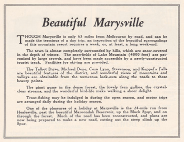
Ephemera (Item) - Advertisement, Beautiful Marysville, Unknown
An advertisement for Marysville and attractions in and around the local area.An advertisement for Marysville and attractions in and around the local area.marysville, victoria, lake mountain, talbot drive, lady talbot drive, michael dene, cora lynn falls, stevenson falls, steavenson falls, keppel's falls, healesville, maroondah reservoir, black spur -
 Marysville & District Historical Society
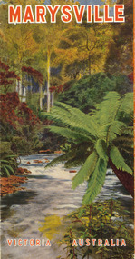
Ephemera (Item) - Tourist brochure, Victorian Railways, Marysville Victoria Australia, 01-1941
A tourist information brochure that was issued by the Publicity and Tourist Services of Victorian Railways, in January, 1941, to promote Marysville and the surrounding district.A tourist information brochure that was issued by the Publicity and Tourist Services of Victorian Railways, in January, 1941, to promote Marysville and the surrounding district.marysville, victoria, cumberland valley, messmate, buxton, taggerty river, acheron way, black's spur, cement creek, keppel falls, steavenson falls, cumberland falls, narbethong, st fillan, taggerty valley, wade's lookout, mount gordon, nicholls lookout, lake mountain, victorian government tourist bureau, victorian railways -
 Marysville & District Historical Society
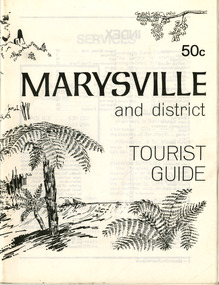
Booklet (Item) - Tourist guide, Ian and Danese Walshe et al, MARYSVILLE and district TOURIST GUIDE, 1982
A tourist guide outlining services, accommodation, activities and places of interest to visit in and around Marysville and the local district.A tourist guide outlining services, accommodation, activities and places of interest to visit in and around Marysville and the local district.marysville, victoria, australia, tourist guide, marysville hotel, castles' store, hawthorne's corner shop, tudor lodge, black spur motel and caravan park, buxton general store, golden fleece roadhouse, marysville garage, burrengeen park, lake mountain, steavenson falls, nanda binya lodge, alpenglow nursery, black spur inn hotel, silver stream trout farm, mccfarlane's grocery, barton's drapery, marysville newsagency, eildon explorer, beauty spot nursery, crossways, pumpernickel, mckenzie's tourist services, blue hills riding school, mountain view horse hire, pitt's garage, maryton park, j l gould sawmill, eildon deer park, eildon weir, maroondah dam, snob's creek, healesville sanctuary, graceburn park, cathedral range, beauty spot walk, tree fern gully walk, michaeldene track, keppel track, woods lookout track, cumberland scenic reserve, cambarville, the big tree, cora-lyn falls, barton's lookout, cumberland falls, sovereign view, wirreanda festival, scenic motel, tower motel, marylands guest house, kooringa guest house, marylyn guest house, mountain lodge, el kanah, marysville hotel motel, buxton hotel motel, black spur inn, buxton caravan park, marysville caravan park, the cumberland, marysville recreation and fun park -
 Marysville & District Historical Society
Booklet (Item) - Leisure guide, Michael Chesire & Associates Pty. Ltd, MARYSVILLE & DISTRICT LEISURE GUIDE-AUTUMN/WINTER, 1986, 1986
A free leisure guide to Marysville and the surrounding district published for Autumn and Winter, 1986. This was produced by Michael Cheshire as a free publication to promote tourism in Marysville and the surrounding district. It includes maps of the Big River Valley, Cumberland Valley, Lady Talbot Forest Drive, the Marysville area, and the township of Marysville. It was released in the autumn of 1986 and was sponsored by the Marysville Tourist & Progress Association. The Association was formed in November 1907 to promote tourism within the area. This included the physical creation of signage, parklands, roads, and walks to various attractions. A free leisure guide to Marysville and the surrounding district published for Autumn and Winter, 1986.marysville, victoria, australia, leisure guide, michael cheshire & associates pty ltd, marysville golf club, blackwood lodges, sir colin mackenzie fauna park, lake eildon, fraser national park, yarra valley wineries, marysville coach tours, kooringa, marylands guest house, lady talbot forest drive, wishing well, taggerty river recreation area, athols abbey, phantom falls, keppel falls, the beeches walking track, marylyn guest house, kufstein inn motel, the cumberland, marysville tourist & progress association, marysville newsagency & general store, crossways restaurant & motel, beauty spot walk, tree fern gully walk, michaeldene track, keppel track, woods lookout track, marysville hotel motel, lake mountain ski hire, marysville recreation and fun park, mytanta horseback safaris, upper big river valley, the big culvert, marysville mountain view horse hire, maryton park, amber view holiday lodges, cathedral restaurant, the top shop, tower motel, menzes garage, beauty spot nursery, marysville ski hire, lake mountain ski school, faraway forest, scenic motel, buxton trout farm, marysville hardware, timbertop steakhouse, marysville trout farm, healesville sanctuary, buxton hotel motel, nanda binya lodge, buxton antique and furniture mart, the black spur inn hotel, alexandra, lake mountain, geoffrey pope & associates -
 Marysville & District Historical Society
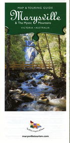
Map (Item) - Map and touring guide, Murrindindi Regional Tourism Association Inc, Marysville & The Mystic Mountains VICTORIA-AUSTRALIA, 08-2002
A fold out map and touring guide of Marysville and the surrounding district published in 2002 by Murrindindi Regional Tourism Association Inc.A fold out map and touring guide of Marysville and the surrounding district published in 2002 by Murrindindi Regional Tourism Association Inc.marysville, victoria, australia, map and touring guide, mystic mountains tourism, the beeches rainforest walk, lake mountain, cambarville, cathedral range state park, the cumberland, abbey green b&b cottages, anastasia fairytale cottage, ashlar cottage b&b, somerled mountain retreat, baree mudbrick cottages, blackwood cottages, camellia cottage, cathedral view b&b, cottage riverside, crossways country inn, dalrymples guest cottages, esa country ministries, hillcrest, keppels hotel motel, kerami house, lomatia lodge, lyell guest cottages, marylands country house, marysville caravan park, marysville holiday cottages, maryton park, melina cottage, moondai farm b&b, mountain lodge marysville, mount cathedral lodge, mystic mountains holiday cottages, nanda binya lodge, rendezvous on murchison, scenic b&b, the hermitage, tower motel, waratah house, willowbank at taggerty, woodlands of narbethong, keppels, lake mountain resort cafe, lanterns at willowbank, mantirri blueberry farm, marysville country bakery, the old woolshed cafe, clearstream olives, uncle fred & aunty val's old style lolly shop, acheron valley alpacas country store & gallery, bruno's art and sculpture garden, country touch, things of sand & stone, willowbank gallery, marysville auto & hardware, marysville newsagency & general store, marysville visitor information centre, narbethong visitor information centre, gallipoli park, keppels lookout, lady talbot drive, steavenson falls, steavenson river, taggerty river, acheron river, black spur trail riding centre, buxton trout farm, lake mountain resort ski hire, lake mountain ski school, marysville district country club, marysville ski centre, narbethong ski hire, rubicon horse riding, country touch tours, murrindindi regional tourism association inc -
 Marysville & District Historical Society
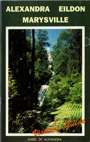
Ephemera (Item) - Visitor's Guide, Shire of Alexandra, ALEXANDRA EILDON MARYSVILLE Visitor's Guide, Unknown
A tourist guide for Alexandra, Eildon and Marysville produced by the Shire of Alexandra.A tourist guide for Alexandra, Eildon and Marysville produced by the Shire of Alexandra.alexandra, eildon, marysville, victoria, australia, tourist guide, steavenson falls, blackwood lodges, marysville hotel motel, the cumberland, gallery restaurant marysville, marysville gallery, cross country ski hire, marylyn guest house, marylands guest house, marysville crafts & gifts, hearts of oak antiques, geoffrey pope & associates, cedron house marysville, amber view holiday lodges marysville, marysville ski hire, lake mountain ski school, fruit salad farm, taggerty general store, arbor green galleries marysville, black spur roadhouse, black spur motel & caravan park, marysville caravan park, the hermitage narbethong, danish coffee garden, maryton park, buxton trout farm, lake mountain outdoor centre marysville, australian bush pioneer's farm, the camel farm and zoo buxton, marysville mountain view horse hire, marysville golf and bowls club, yarrolyn holiday park taggerty, riverland lodge taggerty, beauty spot walk, tree fern gully walk, michaeldene track, keppel track, woods lookout track -
 Marysville & District Historical Society
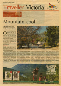
Newspaper (Item) - Newspaper article, The Age, POCKET GUIDE TO MARYSVILLE, 22-11-2008
A newspaper article on Marysville, its local attractions, places to shop and dine, where to stay and ways of traveling to Marysville. This article was published in The Age on Saturday, November 22, 2008.A newspaper article on Marysville, its local attractions, places to shop and dine, where to stay and ways of traveling to Marysville.marysville, victoria, australia, the age, black spur, marysville visitor information centre, steavenson falls, lady talbot drive, taggerty river, keppel falls, phantom falls, beeches rainforest walk, cambarville, yarra ranges national park, the big tree, cumberland walk, lake mountain, steavenson river, acheron river, buxton bait and tackle, marysville trout and salmon ponds, buxton trout and salmon farm, bruno's art and sculpture garden, villa day spa, cathedral view natural therapies, marysville massage, murchison street, village walk, uncle fred & aunty val's old style lolly shop, country touch gallery, manical mechanicals, hidden talent craft gallery, carmyle farm boutique, marysville community market, marysville patisserie, marysville country bakery, fraga's cafe restaurant, terracotta room, marylands country house, the cumberland, mantirri blueberry farm, narbethong, marysville farmers market, the black spur inn, allawah country cottages, barree mud brick cottages -
 Marysville & District Historical Society
Map (Item) - Tourist map, Mystic Mountains Tourism, OFFICIAL VISITORS' MAP MARYSVILLE LAKE MOUNTAIN, Unknown
A visitors' map of Marysville and Lake Mountain produced by Mystic Mountains Tourism for Visit Victoria.A visitors' map of Marysville and Lake Mountain produced by Mystic Mountains Tourism for Visit Victoria.The Marysville and Lake Mountain Visitor Map and Touring Guide has been compiled and/ published by Mystic Mountains Tourism Inc. Copyright./ Production and artwork Graph Attack P/Lmarysville, lake mountain, victoria, australia, visitor's map, official visitors' map marysville lake mountain, buxton, narbethong, taggerty, visit victoria, mystic mountains tourism inc, graph attack p/l, mystic mountains, marysville triangle, marysville visitor information centre, marylands country house, black spur, steavenson falls, lady talbot drive, cambarville, cathedral ranges, wirreanda festival, lake mountain summit walk, summit walk loop, leadbeaters loop, day loop walk, buxton hotel, igloo roadhouse, karmann waters, silverstream b&b cottages, buxton trout and salmon farm, the niche wine bar, buxton post office & general store, choppers buxton roadhouse, woodlands rainforest bungalows, chestnut glade, black spur inn, wombat cottage, abbey lake luxury b&b spa cottages, mystic mountain ski hire & outdoors, pnl 4wdriving, blue views holiday units & ski hire, marapana agistment park & farm stay b&b, danico design, things of sand & stone, mantirri blueberry farm, allawah country cottages, amberview cottages, ashlar cottage b&b, black spur motel & caravan park, blackwood deluxe cottages, blackwood courtyard b&b, dalrymples guest cottages, delderfield, el kanah guest house, fruit salad farm, kerami guest house, keppels hotel, lake mountain-snow gum lodge, lomatia lodge, lyell guest cottages, magnolia house, keppel waters, lyrebird apartments, marysville caravan park, all view spa apartments, riverside cottages, maryton park b&b country cottages, melina cottage, mountain lodge, mystic mountains holiday cottages, nanda binya lodge, rendezvous luxury cottages, scenic b&b motel, the cumberland, south cathedral farm, tower motel, willowbank at taggerty, woodlands rainforest retreat, marysville & district country club inc, mystic mountains ski hire & outdoors, rubicon valley horse riding, marysville trout and salmon ponds, gallipoli park, keppels lookout, cambarville-yarra ranges national park, lake mountain-yarra ranges national park, lady talbot drive-yarra ranges national park, cathedral range state park, steavenson river, taggerty river, acheron river, lake mountain alpine resort, bruno's art and sculpture garden, manical mechanicals, uncle fred & aunty val's old style lolly shop, carmyle farm boutique, crossways historic country inn, fraga's, gilberts restaurant, heights licensed bistro, the old woolshed cafe, cathedral view natural therapies, crystal journey