Showing 1059 items matching "boundaries"
-
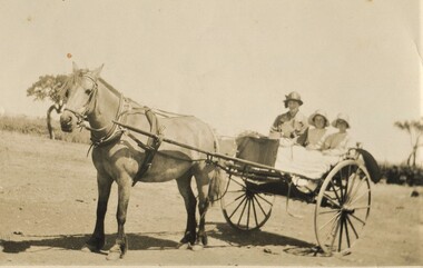 Surrey Hills Historical Society Collection
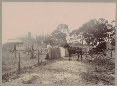
Photograph, Gwen and Beryl Mair and Mrs Jarman in a jinker, Derrinallum, c1927, c1927
David Miller (Dave) Mair (1879-1938) married Lily Vipond Deakin (1890-1945) in 1910. They had 5 children: Geoffrey David (1913-1970), Beryl (1916-1976), Gwynneth (1917-1997), Isabel Lillian (1921-1997) and Shirley Inez (1928-1968). Personal communication from Laurie Newton, Beryl's daughter: Dave and Lily initially lived in East Melbourne after they married. Dave walked across the gardens to work at the MCG. He never drove or owned a car. Geoffrey, Beryl and Gwynneth were born in East Melbourne. They subsequently moved to Louise Avenue, Mont Albert and Isabel may have been born while they were there. Later they purchased 20 Barton Street, Mont Albert. Shirley was born after they moved to Barton Street. Electoral roll details: 1919 1922 24 Louise Avenue, Mont Albert 1924 20 Barton Street, Mont Albert Dave Mair was a very keen sportsman. This is part of a large donation of material from the Deakin, Mair and Young families. The Deakin, Mair and Young families had many connections with Mont Albert and Surrey Hills.A sepia photo of a woman and 2 girls in a jinker. They are all wearing brimmed hats as if going on an outing. Apart from a couple of straggly trees in the background along what may be a boundary or paddock fence, the surroundings look very bare.In blue biro: " Gwen / Beryl / Mrs Jarman / Derrinallum" Thought to be Beryl Mair's handwriting. Photographic process stamp "C 311" "KODAK PRINT" in black. beryl mair, gwen mair, mrs jarman, farms, children, horse-drawn vehicles -
 Bendigo Historical Society Inc.
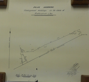
Document - MARKS COLLECTION: UNDERGROUND WORKINGS BALLERSTED & SON
Plan on white paper (copy) of underground workings. On top of plan 'Plan Showing Underground Workings in the claim of Ballerstedt & Son' On bottom date written 29/11/65. Plan shows lease peg, southern boundary of claim.bendigo, mining, ballerstedt & co -
 Bendigo Historical Society Inc.
Map - COMET MINE - PLAN OF COMET MINE
Plan of the Comet Mine on the Hustler's Line of Reefs Bulletin No 33, Plate No XXIV signed by H S Whitelaw, Underground Survey Office Bendigo, September 1913. Upper and Lower Levels and approximate boundaries shown. Depths shown.Geological Survey of Victoriamining, parish map, hustler's line of reefs, comet mine plan bulletin no 33 plate no xxiv -
 Eltham District Historical Society Inc
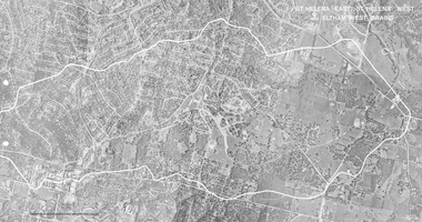
Work on paper (Sub-Item) - Photograph, St Helena East, St Helena West and Eltham West drains, ca 1980
black and white aerial photograph with boundary and drains marked over three page fold out eltham, st helena, drains, aerial view -
 Greensborough Historical Society
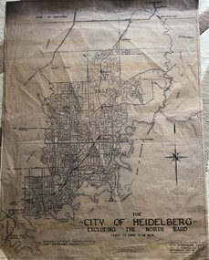
Map, City of Heidelberg, City of Heidelberg, - excluding the North Ward, 1959, 27/05/1959
Map of City of Heidelberg showing municipal and ward boundaries; North Ward is excluded from this map.Blue print map"Scale 20 chns to an inch. G.M.H. 27.5.59"city of heidelberg, heidelberg - maps -
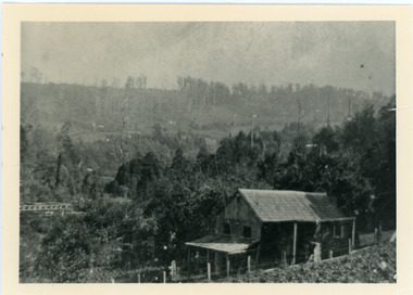 Mt Dandenong & District Historical Society Inc.
Photograph, Harry Child's Hut, early 1900s
Home of Harry Child in foreground built on the southern boundary of his father's (Francis Matthew Child) allotment. Black and white photograph showing the home of Harry Child. This photograph has a detailed inscription on the back handwritten by John Lundy-Clarke.The eastern face of Mt Dandenong from F.M. Childs selection Cnr allotment D.francis matthew child, mt dandenong, harry child -
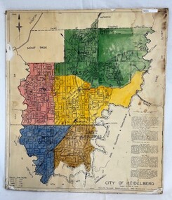 Greensborough Historical Society
Poster - Map, City of Heidelberg, 1965c
Map of the City of Heidelberg showing municipal boundaries and Wards are coloured. Scale 20 chains to 1 inch.An example of hard copy plans from the 1960s. Mainly from the Shire of Diamond Valley era (1964-1994).Colour map, pasted on card and laminated.Stamped and handwritten Council permissions, dates and other details. city of heidelberg, heidelberg - maps, local government -
 Bayside Gallery - Bayside City Council Art & Heritage Collection
Map - print, Melbourne and Metropolitan Board of Works, Interim development order: Brighton, Moorabbin and Sandringham, 1959
The Melbourne and Metropolitan Board of Works (now Melbourne Water) was established in 1891. From that time, as part of their work laying water and sewerage connections, they created detailed plans of houses and other buildings in the Melbourne metropolitan area. In 1956 it acquired powers to construct and maintain highways and bridges, protect and improve the foreshores and create and maintain parks within the metropolitan region. This Interim development order comprises part of the municipalities of Brighton, Moorabbin and Sandringham and was made on 20 October 1959.brighton, moorabbin, sandringham, melbourne and metropolitan board of works, map, town planning, cartographic material, interim development order, bayside -
 Bendigo Historical Society Inc.
Newspaper - BENDIGO HOTEL COLLECTION: NEWSPAPER ARTICLES ON VARIOUS BENDIGO HOTELS
A series of newspaper articles on various Bendigo hotels. The hotels mentioned are: Old Boundary Hotel, Brougham Arms Hotel, British and American Hotel, Belmont Hotel, Black Swan Hotel, Harney;s Bendigo Hotel, Gold Mines Hotelbendigo, hotel, list -
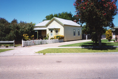 Lakes Entrance Historical Society
Photograph - Historic House, 1999
Built 1900c, cottage was made available for widow and children of Dougal Egan, lost when fishing boat Orme disappeared in 1909. After Mrs Egan married George South, cottage became known as the South House. Later resident Mrs Edith Rawlinson. Cottage restumped, refurbished 2011 / 2012.|Also Two colour photographs various viewsColour photograph of a timber cottage at 26 Church Street, with both hipped and gable iron roof. Triple sided bay window. Sash windows on west side, with window hoods. Western wall is on boundary of allotment. Lakes Entrance Victoriahouses, heritage study -
 Linton and District Historical Society Inc
Photograph, Conversation at the Front Fence, undated
Black and white image mounted on light grey card. Image shows a weatherboard house in background, trees and a boundary fence. Two women are standing at the fence. Other side of the fence is a horse drawn cart with a man and a young female seated there.rural life, horses, horse drawn vehicles, houses -
 St Kilda Historical Society
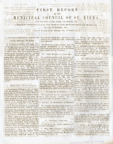
Document - Annual report, First Report by the Municipal Council of St Kilda, 1857
First report of the Municipal Council of St Kilda, for the half-year from 11 March 1857 - 11 September 1857. The Municipal District of St Kilda was proclaimed on 24 April 1855 but the election of the Council was delayed by a dispute over boundaries. This report outlines the process of deciding on the boundaries and establishing the Council, which met for the first time on 11 March 1957.Four-page report, printed double sided on two sheets of folded blue bank papermunicipality of st kilda, st kilda - history, 19th century -
 Ballarat Heritage Services
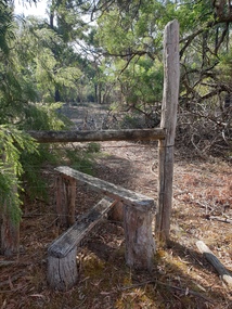
Photograph, Clare Gervasoni, Stile at Clarkesdale Bird Sanctuary, 26/03/2023
A stile is a structure or opening that provides people passage over or through a boundary via steps, ladders, or narrow gaps.[Photographs of a Stile at Clarkesdale Bird Sanctuary. stile, fence, path, timber -
 Tatura Irrigation & Wartime Camps Museum
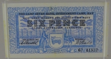
Currency - Bank note, 1st March 1941
Designed by Dunera internee, Teltscher, and printed by Riverine grazier at Hay internment campFacsmilie. Encapsulated/laminated bank note to the value of six pence, with blue colour design(s) on white background with black printing. Features emblem of kangaroo, emu and merino ram above banner of the words "Camp seven bank". Display in plastic stand frameC41937, Printed on back of bank note "This note is valid only within the boundaries of Camp 7 Internment Camp Hay" "The bank is under no obligation to honour this note if presented by holder outside the Camp".tatura, numismatics, notes -
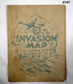 Bendigo Military Museum
Map - INVASION MAP, H.E.C Robinson PTY LTD, Post 1945
Map, Robinsons Invasion Map of part of Europe rectangular shape, countries in seperate colours and boundaries in red, when folded has a front piece in blue showing planes, parachutes, boats and Cities, rear of the fold has a list of maps by Robinsonsmaps, invasion europe, robinsons -
 Port Melbourne Historical & Preservation Society
Photograph - Gasworks demolition, 1979
Six small photographs of gasworks demolition in about 1979 1. Lagoon, Esplanade East, boundary of Lagoon Reserve 2. Upright crash frame 3. Mangled cranes 4. Graham st 5. Fallen crane 6. Fallen cranebuilt environment - industrial, utilities - gas, gasworks, demolition, sandridge lagoon, lagoon reserve -
Port Melbourne Historical & Preservation Society
Document - Photocopy, maps, 1890s maps, 30 April 1890 .01 11 March 1890 .02
.01 Copy of Map 3084B - Port Melbourne, Willamstown Road to Esplanade East; to Graham Street; to Boundary Road & Pickles Street. .02 Copy of map of Port Melbourne, Bay Street to Clark Street; to Foreshore; to Pickle Street & Spring Street..01 for title information see parcels index 47,53,54,55,56 & 57. .02 Parcels index 3084-B 16 (City of Port Melbourne)built environment - commercial, built environment - domestic, city of port melbourne, parish of south melbourne -
Tatura Irrigation & Wartime Camps Museum
Sculpture - Sandstone Maps of Australia, 1940
2x hand carved sandstone maps of Australia with space for penny in one & metal kangaroo in other. 1. Space for penny in centre. Markings for state boundaries. Creamy coloured stone. 2. Metal (copper?) kangaroo in centre. Pink tinged stone.1. Tatura 1940 2. 1940 Taturatatura;, handcrafts, carving -
Whitehorse Historical Society Inc.
Map, Dandenong Ranges area. Sheet 7, c1957
Detailed map covering area from Mitcham and Vermont to Ringwood and Heathmont.Detailed map covering area from Mitcham and Vermont to Ringwood and Heathmont. Shows streets, block boundaries, buildings, railway and creeks. Note says prepared from State Aerial Survey, April 1954 and Cadastrial Survey information July 1956.Detailed map covering area from Mitcham and Vermont to Ringwood and Heathmont. maps, mitcham, vermont, ringwood, heathmont -
 University of Melbourne, Burnley Campus Archives
Plan, School of Horticulture -Burnley, 1950
Same layout as plan at B91.0471, but showing PMG cables, and buildings existing, proposed and temporary or for demolitionPlan showing layout of PMG cables and PMG plant. Area bounded by Swan St., Yarra Boulevard, orchard, vegetable garden, market garden and S.W. Boundary to Stockman's Cottage. PMG layout handwritten. On same plan as B91.0484 (original) and B11.0383.burnley school of horticulture, orchard, gardens, vegetables, stockman's cottage -
 Eltham District Historical Society Inc
Document - Folder, Municipal changes of the Shire of Eltham, 1994
Unsourced information including a list of dates, when boundaries were changed and what areas were affected and corresponding population I page. Handwritten notespopulation, statistics, census, shire of eltham, harry gilham collection -
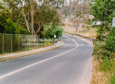
 Eltham District Historical Society Inc
Photograph, Doug Orford, Bridgeworks on Fitzsimons Lane across Yarra River, Eltham, 1991, 1991
From a collection of 35 photos taken by Doug Orford at 35 specific locations along the exact boundary of the then Shire of Eltham.Colour photographbridges, fitzsimons lane, yarra river -
 Eltham District Historical Society Inc
Photograph, Doug Orford, Bridge, Henty Road, Lower Plenty, 1991, 1991
From a collection of 35 photos taken by Doug Orford at 35 specific locations along the exact boundary of the then Shire of Eltham.Colour photographbridges, henty road, lower plenty -
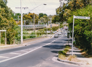
 Eltham District Historical Society Inc
Photograph, Doug Orford, Bridge across Plenty River, Main Road, Lower Plenty, 1991, 1991
From a collection of 35 photos taken by Doug Orford at 35 specific locations along the exact boundary of the then Shire of Eltham.Colour photographbridges, lower plenty, main road, plenty river -
 Eltham District Historical Society Inc
Photograph, Doug Orford, Bridge across Plenty River, Para Road, Briar Hill, 1991, 1991
From a collection of 35 photos taken by Doug Orford at 35 specific locations along the exact boundary of the then Shire of Eltham.Colour photographbridges, plenty river, para road, briar hill -
 Eltham District Historical Society Inc
Photograph, Doug Orford, Mountain View Road, Briar Hill, near River Street, 1991, 1991
From a collection of 35 photos taken by Doug Orford at 35 specific locations along the exact boundary of the then Shire of Eltham.Colour photographbriar hill, mountain view road -
 Eltham District Historical Society Inc
Photograph, Doug Orford, Leach Street, Briar Hill, near Essex Street, 1991, 1991
From a collection of 35 photos taken by Doug Orford at 35 specific locations along the exact boundary of the then Shire of Eltham.Colour photographbriar hill, leach street -
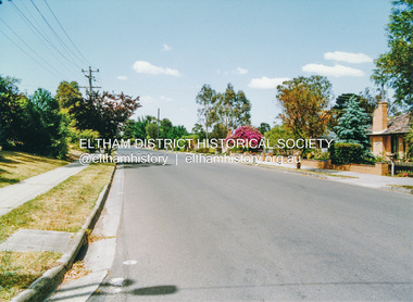
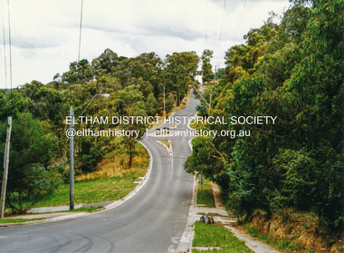
 Eltham District Historical Society Inc
Photograph, Doug Orford, Karingal Drive, Eltham, near Ramptons Road, 1991, 1991
From a collection of 35 photos taken by Doug Orford at 35 specific locations along the exact boundary of the then Shire of Eltham.Colour photographkaringal drive, eltham -
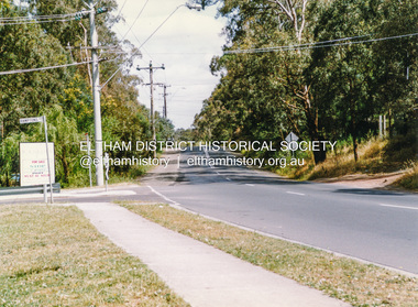
 Eltham District Historical Society Inc
Photograph, Doug Orford, Warringah Crescent, Eltham, near Ramptons Road, 1991, 1991
From a collection of 35 photos taken by Doug Orford at 35 specific locations along the exact boundary of the then Shire of Eltham.Colour photographeltham, warringah crescent -
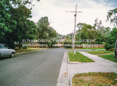
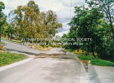
 Eltham District Historical Society Inc
Photograph, Doug Orford, Ryans Road, Eltham, near Kerrie Crescent, 1991, 1991
From a collection of 35 photos taken by Doug Orford at 35 specific locations along the exact boundary of the then Shire of Eltham.Colour photographeltham, ryans road