Showing 655 items
matching bourke road
-
 Whitehorse Historical Society Inc.
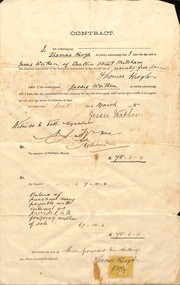
Document, Mitcham, 1/03/1915
Contract of sale of part Crown Portion 119,05 Mitcham, Parish of Nunawading, County of Bourke being Lot 6 on plan of subdivision No. 5339, by Thomas Keogh to Jessie Wathenland sales, wathen, jessie, keogh, thomas, mitcham -
 Whitehorse Historical Society Inc.
Article, Ballyshanassy
Paragraph about Ballyshanassy (County of Bourke) in the Victorian GazetteerParagraph about Ballyshanassy (County of Bourke) in the Victorian GazetteerParagraph about Ballyshanassy (County of Bourke) in the Victorian Gazetteerballyshanassy shire of nunawading, bourke -
 Whitehorse Historical Society Inc.
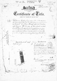
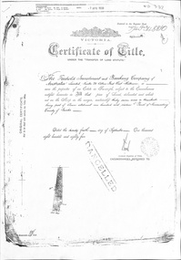
Document, Certificate of Title, 1/06/1908
Photocopy of Certificate of Title Vol 3271 Fol 654003, 50 acres fronting on Canterbury Road, including Scott Street being part of Crown Portion 124, Parish of Nunawading, County of Bourke, in the name of William Scott, 20 June 1908; transfers to 8 October 1936 with notes of previous owners of parts of lot 124 from November 1858.scott street, mitcham, scott, william, polak, nelson, land subdivision, canterbury road, vermont, mitcham road, isaak, johnson, miller frederick, james, becker, lydia malvina, huffey, harry, graham, annie bella, langford, william allan, emily mary, caplin, ethel grace, armstrong, mary, cook, joseph allan, isabella, isaac william, mettzke, frederick oscar, whitmore, doris margaret, elizabeth, thomas, stephen, beach, william griffin, brown, hosking, bonnel, alphonse, saul, martin, richards, twose, richard frederick, charles, george, ham, cornelius job, sprigg, shaw, gavin, william barker, jane, mcclelland, david goodwin, thomas robert -
Whitehorse Historical Society Inc.
Document, What happened to Norwich?
Norwich, consisting of 475 acres in the Parish of Nunawading, County of Bourke, found on a land sale map in the La Trobe collection of Vale maps.Norwich, consisting of 475 acres in the Parish of Nunawading, County of Bourke, found on a land sale map in the La Trobe collection of Vale maps. Research by Jean Uhl into the fate of the proposed township.Norwich, consisting of 475 acres in the Parish of Nunawading, County of Bourke, found on a land sale map in the La Trobe collection of Vale maps. local history, uhl, jean, parish of nunawading, norwich village, vermont, lobb, john, graham, thomas -
Whitehorse Historical Society Inc.
Map, Plan, 1939
Plan of subdivision, part of crown portion 83A and 83, Parish of Nunawading, County of BourkePlan of subdivision, part of crown portion 83A and 83, Parish of Nunawading, County of BourkePlan of subdivision, part of crown portion 83A and 83, Parish of Nunawading, County of Bourkestreet names, parish of nunawading, station street, blackburn, railway road, blackburn, vine street, blackburn, south parade, blackburn, laburnum street, blackburn, main street, blackburn, gardenia street, blackburn, the avenue, blackburn, fuschia street, blackburn, linum street, blackburn -
Whitehorse Historical Society Inc.
Map, Parish of Nunawading, 1939
Plan of subdivision part of crown portions 81, 82 and 89,Plan of subdivision part of crown portions 81, 82 and 89, Parish of Nunawading, County of Bourke, Blackburn Wellington Avenue amended from Stanley RoadPlan of subdivision part of crown portions 81, 82 and 89, street names, parish of nunawading, blackburn road, blackburn, wellington avenue, blackburn, wolseley crescent, blackburn, gordon crescent, blackburn, clarke street, blackburn, central road, blackburn -
Whitehorse Historical Society Inc.
Document, Certificate of Title, 1913 - 1933
Certificate of Title, Mary Elizabeth Allen of Blackburn Road, Blackburn for land, part of Crown Portion 89 at Blackburn Parish of Nunawading County of Bourke.Certificate of Title, Mary Elizabeth Allen of Blackburn Road, Blackburn for land, part of Crown Portion 89 at Blackburn Parish of Nunawading County of Bourke. Vol 3698 Fol 739579 June 19143 also correspondence on rates, 1933.Certificate of Title, Mary Elizabeth Allen of Blackburn Road, Blackburn for land, part of Crown Portion 89 at Blackburn Parish of Nunawading County of Bourke. land titles, shire of nunawading, shire of blackburn and mitcham, allen, mary elizabeth, blackburn road, blackburn -
Whitehorse Historical Society Inc.
Document, Certificate of Title, 1917 - 1933
Certificate of Title, Harrison Rotherham of 'Thulecroft', Albion Street, Surrey Hills, Merchant.Certificate of Title, Harrison Rotherham of 'Thulecroft', Albion Street, Surrey Hills, Merchant. Lots 61 & 62, subdivision 602, Part of Crown Allotment 127, Parish of Nunawading, County of Bourke with a right of carriage way over Harrison and Burnett streets, 1917. Vol 4046, Fol 809049. Also correspondence re rates, enforcement of charge, 1933.Certificate of Title, Harrison Rotherham of 'Thulecroft', Albion Street, Surrey Hills, Merchant.land titles, shire of nunawading, shire of blackburn and mitcham, rotherham, harrison, harrison street, mitcham, burnett street, mitcham -
Whitehorse Historical Society Inc.
Document, Certificate of Title, 1922, 1933
Certificate of Title, Margaret Kennedy.Certificate of Title, Margaret Kennedy. Lots 100, 101 & 102, subdivision 1968, part of crown allotment 1270, Parish of Nunawading, County of Bourke 1922 vol 4583, fol 916577 also rates enforcement of charge, 1933.Certificate of Title, Margaret Kennedy.land titles, shire of blackburn and mitcham, kennedy, margaret, mcdowall street, mitcham -
Whitehorse Historical Society Inc.
Document, Certificate of Title, 1921, 1933
Certificate of Title, Charles Norris and William Richard Norris.Certificate of Title, Charles Norris and William Richard Norris. Lot 6 Subdivision 4894, part of crown portions 89 & 90, Parish of Nunawading, County of Bourke 1922. Vol 4474, fol 894734 also correspondence re rates, enforcement of charge 1933.Certificate of Title, Charles Norris and William Richard Norris.land titles, shire of blackburn and mitcham, norris, charles, norris, william richard, blackburn road, blackburn -
Whitehorse Historical Society Inc.
Document, Certificate of Title, 1923 - 1934
Certificate of Title, William Arthur Hirst.Certificate of Title, William Arthur Hirst. Lot 20 Subdivision 6626, part of crown allotment 127A at Mitcham, Parish of Nunawading, Count of Bourke. Vol 4671, fol 934063. Also correspondence re rates enforcement charge, 1933-34.Certificate of Title, William Arthur Hirst.land titles, shire of blackburn and mitcham, hirst, william arthur, shire of nunawading, thomas street, mitcham -
Whitehorse Historical Society Inc.
Document, Certificate of Title, 1915, 1933
Certificate of Title, Frederick William GibbonsCertificate of Title, Frederick William Gibbons, Lot 88, Subdivision 1968, part of crown allotment 1270, Parish of Nunawading, County of Bourke 1915. Vol 3882, fol 776385 also correspondence re rates, enforcement of charge, 1933.Certificate of Title, Frederick William Gibbonsland titles, shire of blackburn and mitcham, gibbons, frederick william, shire of nunawading, burnett street, mitcham, gort road, mitcham -
Whitehorse Historical Society Inc.
Document, Certificate of Title, 1910, 1928, 1933
Certificate of Title, Albert Edward Ruglen.Certificate of Title, Albert Edward Ruglen. Part of Crown Allotment 118A, Parish of Nunawading, County of Bourke, 1910. Vol 3462 fol 692315 also correspondence re rate enforcement of charge. Another certificate of title for the same person, subdivision 12279, vol 5389 fol 1077705 1928 and rates - enforcement of charge 1933.Certificate of Title, Albert Edward Ruglen.ruglen, albert edward -
Whitehorse Historical Society Inc.
Document, Certificate of Title, 1928, 1933-1934
Certificate of Title, Nanny Schifferdecker.Certificate of Title, Nanny Schifferdecker. Lots 44, 45,56 & 57 subdivision 3360 Crown portion 97 Parish of Nunawading, County of Bourke 1928. Vol 5406 fol 10881070 1928, Agnew and Craig Streets. Also correspondence re rates enforcement charge 1933.Certificate of Title, Nanny Schifferdecker. land titles, shire of blackburn and mitcham, schifferdecker, hanny, craig street, blackburn south, agnew street, blackburn south -
 Whitehorse Historical Society Inc.
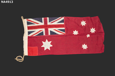
Flag - Flag Red Ensign -small
Belonged to Mr. W Hawkins who founded the Carry On Club in 1932. A group of returned servicemen nd business men of Melbourne . The aim of the club was to assist many World War I veterans who were experiencing hard times after the economic collapse of 1929Australian Red Ensign. Upper left on Hoist side Red Cross over-sewn over-sewn on White cross over-sewn on Navy blue background. Commonwealth(Federal) star lower Left on hoist side white 7 points Southern cross four stars white 7 points, one white star small 5 points. Red square patch : lower left on hoist side Cord Loop top left on hoist side. Cord bottom left on hoist sideThomas Evans Pty Ltd 415 Bourke Street Melbourneflags, national -
 Whitehorse Historical Society Inc.
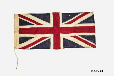
Flag - Union Flag Of United Kingdom (Union Jack) Small
Belonged to Mr W Hawkins who founded the Carry On Club in 1932. A group of businessmen and returned servicemen of Melbourne. The club was formed to help World War Veterans who were experiencing hard times after the economic collapse of 1929Union Flag. Red cross over-sewn on White Cross over-sewn on Blue Background Cord Loop on upper Hoist side Cord length on lower hoist side (25.5 cms)Thos Evans Pty Ltd 415 Bourke St Melbourneflags, national -
Whitehorse Historical Society Inc.
Map, Springfield Road, Blackburn, 1924
Plan of subdivision, parts of Crown Portions 73 and 74, parish of Nunawading, County of Bourke.Plan of subdivision, parts of Crown Portions 73 and 74, parish of Nunawading, County of Bourke. Passed by MMBW 24 May 1924. Subdivision not implemented. Originally owned by Leonard Sherwin Bayley, then by Edward Henry Pearce, then by Ron Pearce. Part compulsorily acquired as site for Blackburn High School. With historical notes by Ron Pearce.Plan of subdivision, parts of Crown Portions 73 and 74, parish of Nunawading, County of Bourke. bayley, leonard sherwin, pearce, edward h, pearce, ronald harry, orchards, blackburn high school, north blackburn square shopping centre -
Whitehorse Historical Society Inc.
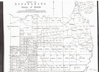
Map, The Parish of Nunawading, 1853
Photocopy of manuscript plan with allotments numbered and some named.Photocopy of manuscript plan with allotments numbered and some named. Note on verso: The Parish of Nunawading in the County of Bourke; lithographed at the Surveyor General's office by J.Jones Jan 18th 1853. Endorsed Sale Plan 271. Dray tracks, water holes and terrain indicated.Photocopy of manuscript plan with allotments numbered and some named. land subdivision, maps, parish of nunawading, jones, j -
Whitehorse Historical Society Inc.
Map, Parish of Nunawading, 1853
Photocopy of manuscript map with allotments numbered and named.Photocopy of manuscript map with allotments numbered and named. Note on verso: Parish of Nunawading, County of Bourke. Gardiners Creek, Ballyshanassey Township, surveyed by H. Parmein, Surveyor General's office, Nov 30th 1853 [enlargement of ND2801, no list of corner references]Photocopy of manuscript map with allotments numbered and named. maps, gardiners creek, ballyshanassy, burwood east, parmein, h -
Whitehorse Historical Society Inc.
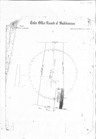
Map, Plan of special survey selected by H. Elgar Esq, 1841
Photocopy of plan and listing of corner stakes.Photocopy of plan and listing of corner stakes. Note on verso: Plan of special survey selected by H. Elgar Esq in the Parishes of Boroondara and Nunawading, County of Bourke. Surveyed by T.H. Nott (?Sydney) 31 May 1841. Boroondara Special Survey B.17, with attached descriptive note by T. H. Nott.Photocopy of plan and listing of corner stakes. maps, parish of boroondara, parish of nunawading, elgar, h, nott, t.h. -
 Whitehorse Historical Society Inc.
Document, Plan of Parish of Nunawading, 01/05/1864
Copy of plan of Parish of NunawadingCopy of plan of Parish of Nunawading, County of Bourke, lithographed at the Office of Lands and Survey, Melbourne, 13th May, 1864 showing boundaries of Koonung, Mullum Mullum and Dandenong Creeks.Copy of plan of Parish of Nunawadingland subdivision, parish of nunawading, county of bourke, elgars special survey, koonung creek, mullum mullum creek, dandenong creek -
Whitehorse Historical Society Inc.
Letter - Correspondence, Unlicensed charcoal burners at Nunawading, 1864
Letter to Superintendent of Police from Mounted Constable Philip Purcell, November 1864 about unlicensed charcoal burners on crown land.Letter to Superintendent of Police from Mounted Constable Philip Purcell, November 1864 about unlicensed charcoal burners on crown land.Letter to Superintendent of Police from Mounted Constable Philip Purcell, November 1864 about unlicensed charcoal burners on crown land.charcoal burning, bourke district - nunawading, purcell, philip -
Whitehorse Historical Society Inc.
Legal record - Land Title, Blackburn
Plan of subdivision of part of Crown Portions 81,92 and 89, Parish of Nunawading, County of Bourke. Photograph produced 11 Aug 1947.Plan of subdivision of part of Crown Portions 81,92 and 89, Parish of Nunawading, County of Bourke. Photograph produced 11 Aug 1947.Plan of subdivision of part of Crown Portions 81,92 and 89, Parish of Nunawading, County of Bourke. Photograph produced 11 Aug 1947.blackburn road, blackburn, wellington avenue, central road, gordon crescent, wolseley crescent -
 Whitehorse Historical Society Inc.
Document, Crown Allotment
Land documents relating to Crown Allotment 116 Shady Grove Nunawading Parish of Nunawading County of BourkeLand documents relating to Crown Allotment 116 Shady Grove Nunawading Parish of Nunawading County of BourkeLand documents relating to Crown Allotment 116 Shady Grove Nunawading Parish of Nunawading County of Bourkeland titles, holmes, dave, shady grove nunawading no.76, helen, jobbins, thomas, the freehold investment and banking company of australia ltd, wilson, david duncan butchart, boyle, walter, holbery, emily rachel, fisher, james cowley morgan -
 Whitehorse Historical Society Inc.
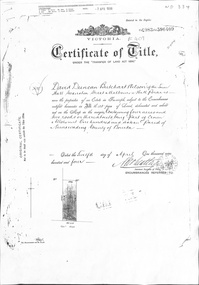
Certificate - Certificate of Title, Crown Allotment, 12/04/1904
Certificate of Title dated 12/4/1904 covering land in Shady Grove, Nunawading purchased by David Duncan Butchart Wilson. Crown Land Allotment No. 116 Parish of Nunawading County of Bourkeland titles, wilson, david duncan butchart, shady grove nunawading no. 76, higgins, mary, alcock, horace, holmes, dave, thumberstone, henry, helen -
 Whitehorse Historical Society Inc.
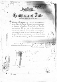
Certificate - Land Title document, Crown Allotment, 5/11/1909
Certificate of Title dated 5/11/1909 covering land in Shady Grove Nunawading purchased by Mary Higgins. Crown Land Allotment No. 116 Parish of Nunawading County of Bourke.land titles, higgins, mary, holmes, dave, shady grove nunawading no.76, helen -
 Whitehorse Historical Society Inc.
Certificate - Land Title Document, Crown Allotment, 24/9/1885
Certificate of Title dated 4/9/1885 covering land in Shady Grove Nunawading purchased by The Freehold Investment and Banking Company. Crown Allotment No. 116 Parish of Nunawading County of Bourkeland titles, shady grove nunawading no. 76, crown land allotment no. 116, the freehold investment and banking company of australia ltd., higgins, mary, holmes, dave, wilson, david duncan butchart, helen -
Whitehorse Historical Society Inc.
Map, Directory Maps of the County of Bourke, 1892
Directory maps of the County of Bourke, containing all the Parishes ...Directory maps of the County of Bourke, containing all the Parishes ... also a complete map of the Colony of Victoria, showing all the Counties, Parishes, Railways and stations to date, and the Mallee Blocks. Lithographed by G.S.B. Bonney for the Victorian Shire Map Company. Scale: 40 chains to the inch.Directory maps of the County of Bourke, containing all the Parishes ...maps, victoria. county of bourke, t.r.b. morton & son -
Whitehorse Historical Society Inc.
Document, Plan of Box Hill and district, 1890?
Collins' plan of Box Hill and district.Collins' plan of Box Hill and district.Collins' plan of Box Hill and district.box hill, county of bourke, plans -
 Whitehorse Historical Society Inc.
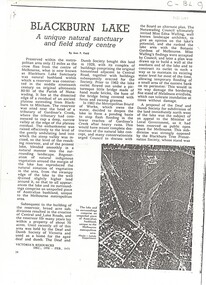
Article, Blackburn Lake, 1971
'Victoria's Resources' Dec 1970 - Feb 1971 - 'Blackburn Lake: a unique natural sanctuary and field study centre - author Jean F. Field.An article from 'Victoria's Resources' Dec 1970 - Feb 1971 - 'Blackburn Lake: a unique natural sanctuary and field study centre - author Jean F. Field. History and description of the lake including bird lists. 'Victoria's Resources' Dec 1970 - Feb 1971 - 'Blackburn Lake: a unique natural sanctuary and field study centre - author Jean F. Field.parks and reserves, blackburn lake sanctuary, adult deaf and dumb society, melbourne and metropolitan board of works, walling, edna, sheddon, (mrs), (mr), bourke, nola