Showing 289 items matching "david small"
-
 Kew Historical Society Inc
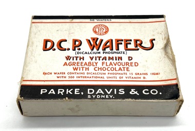
Container - D.C.P. Wafers
D.C.P. Wafers were produced by Park, Davis & Co, Sydney. This U.S.-based company was started in Detroit in 1866. It was once the largest pharmaceutical company in the world. The active ingredient - Dibasic calcium phosphate. Small printed cardboard box, once containing wafers of D.C.P. Wafers, containers, park david & co -- sydney, d.c.p wafers -
 Kew Historical Society Inc
Journal, Kew Historical Society, Newsletter No.127, June 2019
Yarra Views / Robert Baker p1. Society News: Events, Grants, New exhibition, [Donations to] The collection, RHSV award p3. Stitch Your Way into History / Collections Group p4. Broadcasting from Kew / David White p5. Kew Historical Society 1974-1989 / Robert Baker p7. Resurrection: the Outer Circle railway - Part 2 / Desley Reid p9. Edgevale Road: a small shopping strip in Kew / Judith Scurfield p10. Membership & Donations p12.Published quarterly since 1977, the newsletters of the Kew Historical Society contain significant research by members exploring relevant aspects of the Victorian and Australian Framework of Historical Themes. Frequently, articles on people, places and artefacts are the only source of information about an aspect of Kew, and Melbourne’s history.non-fictionYarra Views / Robert Baker p1. Society News: Events, Grants, New exhibition, [Donations to] The collection, RHSV award p3. Stitch Your Way into History / Collections Group p4. Broadcasting from Kew / David White p5. Kew Historical Society 1974-1989 / Robert Baker p7. Resurrection: the Outer Circle railway - Part 2 / Desley Reid p9. Edgevale Road: a small shopping strip in Kew / Judith Scurfield p10. Membership & Donations p12.kew historical society (vic.) -- periodicals., kew historical society (vic.) -- newsletters, kew historical society (vic.) -- journals -
Kew Historical Society Inc
Journal, Kew Historical Society, Newsletter No.119, June 2017
Conservation & Restoration {Halfey portraits, Kew Where We Live) / Robert Baker p1.Scouts & Guides in Kew; Donations to the collection p2. The Collection: Is it nationally significant? / Robert Baker p4. The Kew Steamroller / David White p6. Exhibitions July to September 2017 / Judith Scurfield p7. Kew Voluntary Aid Detachment / Robert Baker p.8. The Small Homes Service / Felicity Renowden p10.Published quarterly since 1977, the newsletters of the Kew Historical Society contain significant research by members exploring relevant aspects of the Victorian and Australian Framework of Historical Themes. Frequently, articles on people, places and artefacts are the only source of information about an aspect of Kew, and Melbourne’s history.non-fictionConservation & Restoration {Halfey portraits, Kew Where We Live) / Robert Baker p1.Scouts & Guides in Kew; Donations to the collection p2. The Collection: Is it nationally significant? / Robert Baker p4. The Kew Steamroller / David White p6. Exhibitions July to September 2017 / Judith Scurfield p7. Kew Voluntary Aid Detachment / Robert Baker p.8. The Small Homes Service / Felicity Renowden p10.kew historical society (vic.) -- periodicals., kew historical society (vic.) -- newsletters, kew historical society (vic.) -- journals -
Kew Historical Society Inc
Journal, Kew Historical Society, Newsletter No.118, March 2017
... for people of small means / David White p6. Remembering Kew [Kew Town ...Women's History / Robert Baker p1.Society news p2. Women working: a short history of the Kew Ladies' Benevolent Society / Suzanne McWha p4. Dwellings for people of small means / David White p6. Remembering Kew [Kew Town Hall 1865-1971; Ordsall 1858-1970] / Kerry Fairbank & Robert Baker p8. William James Runting / Desley Reid p.9. Mayoral mementoes in the collection / Robert Baker p10. Recent donations / Robert Baker p10.Published quarterly since 1977, the newsletters of the Kew Historical Society contain significant research by members exploring relevant aspects of the Victorian and Australian Framework of Historical Themes. Frequently, articles on people, places and artefacts are the only source of information about an aspect of Kew, and Melbourne’s history.non-fictionWomen's History / Robert Baker p1.Society news p2. Women working: a short history of the Kew Ladies' Benevolent Society / Suzanne McWha p4. Dwellings for people of small means / David White p6. Remembering Kew [Kew Town Hall 1865-1971; Ordsall 1858-1970] / Kerry Fairbank & Robert Baker p8. William James Runting / Desley Reid p.9. Mayoral mementoes in the collection / Robert Baker p10. Recent donations / Robert Baker p10.kew historical society (vic.) -- periodicals., kew historical society (vic.) -- newsletters, kew historical society (vic.) -- journals -
 Beechworth Honey Archive
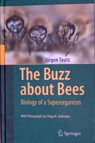
Publication, The Buzz About Bees - Biology of a Superorganism (Jurgen Tautz) 2009, Translated by David C. Sandeman, Photographs by Helga R Heilmann, 2009
Hardcover book, slightly larger than A5. Two tone green cover with a photo of 3 bees on the front with yellow writing & a small photo of bees chaining on the back & a blurb about the book in white writing 284 pages -
 Surrey Hills Historical Society Collection
Card - Christmas card
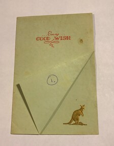
Ernest Lance Young was born 24 March 1915 in Surrey Hills, the son of Ernest Augustus Young and Ruby Nichell Whitty. He married Beryl Mair in 1939 and died on 5 October 1999 at Mont Albert. Beryl Mair (1916-1976) was the daughter of David Miller (Dave) Mair and Lily Vipond Deakin. Dave Mair (1879-1938) was founder of the Kangaroo Cricket Club based at the MCG. The logo or emblem of the club was a kangaroo facing forward. From this one can assume that Mr Holland was a member of the club. The card was most probably sent prior in 1939 or soon after as following Dave Mair's death, as a mark of respect, the emblem was changed to a kangaroo facing to the left but with its head turned back. (Information from the donor).This is part of a large donation of material relating to the Deakin, Mair and Young families, all of whom had connections with Surrey Hills / Mont Albert. The donor is the daughter of Ernest Lance and Beryl Young.A light green card on thin paper with a total size slightly smaller than A4, folded into four. The lower edge of the front is folded back to reveal an embossed figure of a kangaroo facing forward in burnished gold. Inside are printed greetings personalised from Mr Holland and Marion to Mr and Mrs Young.On the folded triangle of the front in blue biro is the later addition of the number one within a circle. This mark was made by the donor. Inside in blue ink, inner LH side: "To / Mr. & Mrs. Young"; signed below the printed standard greeting in the same hand " Mr. Holland / & / Marion"christmas card, dave mair, david miller mair, ernest lance young, beryl mair, beryl young, mr. - holland, kangaroo club -
 Surrey Hills Historical Society Collection
Photograph, Ray & David Theodoridis of Russell Street, 1960s
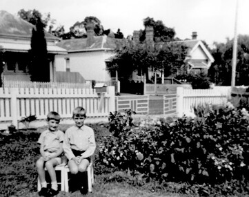
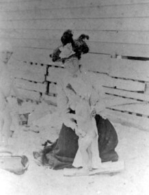
The boys have been identified as *Rea & David Theodoridis. they being 2 of 5 children of Peter and Ruth (nee Dawson) Theodoridis. Background shows Nos 11, 13 and 15 Russell Street in the 1960's. In the 1920s-1930s these were the homes of the Scott, Daniels & Hendy families. No 11 was the home of the Scott family (dem); no 13 may also have belonged to the Scott family. No 18 Russell Street, the family home of Eleanor (Lena) & Rea Dawson. * spelling authenticated by Theodata Williams Dec 2019A black and white photograph of two young boys sitting on small chairs in a front garden. There are two houses in the background on the other side of the road.russell street, surrey hills, scott family, daniels family, hendy family, (mr) david theodoridis, (mr) george david theodoridis, (mr) rae theodoridis -
 Surrey Hills Historical Society Collection
Photograph, Mrs Blanche Cornell
Mrs Blanche Cornell, wife of Frank Cornell, at the beach with 2 of her children, ? c1905 Frank Cornell was first listed in Surrey Hills in 1906 at (6) Lorne Parade. In 1908 the listing gives his occupation as a clerk. He was born in 1869 in Richmond, Victoria and died 15 April 1917 in Surrey Hills. Blanche Annie Parsons Cornell (nee Bracher) was born in 1869 in Hokitika, New Zealand; she died on 21 January 1940. Children were: Gilbert Frank Cornell (b1894, Hawthorn; d1908, at Frankston beach, an accidental drowning) Ruth Amelia Cornell (b 1899, Kew; d 29 May 1977, Kew) Lorna Amy Cornell (b 1906, Surrey Hills; d unknown) Patience Blanche Cornell (b1907, Surrey Hills; d unknown. Frank and wife Blanche are buried in Box Hill Cemetery - CE-*-1058. Ruth Amelia married David Ellis, c1922 in Surrey Hills. David was a dentist who practised in Surrey Hills for many years. Patience (Pat) Blanche married Norman Henry Brewer (1893–1975) in 1931 in Surrey Hills. Given the children's dates of birth, it is likely that it is Gilbert and Ruth in the photo. A black and white photograph of a lady dressed in an ankle length skirt, long sleeved blouse and wearing a hat. She is sitting on the beach and drying off one small girl. There is another small girl or boy to the left of the lady.clothing and dress, 1908, (mrs) blanche cornell, beach, (mrs) blanche annie parsons cornell, (miss) blanche annie parsons bracher, box hill cemetery -
 Surrey Hills Historical Society Collection
Photograph, Parade in celebration of King Edward VII's birthday, 1902, 1902
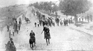
The parade was held in celebration of King Edward VII's birthday on 4 July 1902. This was the first public appearance of the German Band formed on 30 May 1902. The leading horseman is Mr Rowland Coe. He is followed by Mr George Robinson, a butcher of Canterbury Road. The man in the white hat is Mr Sam Kellett, businessman of Erasmus Street. Behind him on foot and partly obscured is Mr Alexander McNeill of the Surrey Family Hotel. Band master is Harry Pollard, painter and paper-hanger, and next to him is Constable Hill. The small boy in the sailor suit is Perc Venman of Essex Road and in the buggy near the footpath is Mr and Mrs William Maling. Information came from David Staig senior. Further research: William Saunders Maling, a son of John Butler Maling, was a builder who lived at 17 Balwyn Road, Canterbury. Rowland Coe, a butcher and son of James and Elizabeth Coe of Sunbury Crescent enlisted in AIF in WW1. He later lived at 233 Elgar Road, Box Hill. William Percival Reginald (Perc) Venman was born in Surrey Hills in 1894; he died in Surrey Hills in 1951 and lived at 27 Essex Street for much of his life. He and his wife are buried in Box Hill Cemetery. The identity of Sam Kellett of Erasmus Street is questioned. Edward Kellett built 'Yielma' in Erasmus Street but was deceased by 1902. He had 3 sons: Edward Allan (1854-1932); George Henry (1858-1921) and William John (1865-1945).Black and white photo of a number of men on horses leading a parade down Station Street (Windsor Crescent) to Union Road. Street trees on the RHS are mature whilst the ones on the LHS look to be newly planted. They have wooden guards around them. The area to the left is blurry but would be the railway line and station surrounds. Roads are well formed with bluestone channels.parades and processions, bands, german band, windsor crescent, william saunders maling, mrs hannah maling, miss hannah miller, constable hill, perc venman, george robinson, sam kellett, alexander mcneill, rowland coe, harry pollard, william percival reginald venman -
 Brighton Historical Society
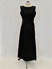
Evening dress and bag, 1950s
This dress and bag belonged to Mrs Edith "Dot" Paroissien (nee Jackson, born 1916), who lived in Brighton with her husband David William Paroissien. The dress was purchased from Croyde, a Melbourne designer who had a small boutique shop in Collins Street near the Block Arcade, and the bag was bought for her in London by David. Dot recalled wearing the dress in the 1950s, in particular to a ball at the Royal Exhibition Buildings for Wesley College. She wore it with suede shoes with a medium heel with straps across the instep and long white kid gloves, and accessorised with a baguette choker and drop earrings.Black silk satin sleeveless full-length evening dress. The attached bodice floats over the top of the under-dress. Asymmetrical opening on bodice which features five large flat self-covered buttons. The black suede bag has chrome fittings and buttery cream coloured satin interior. .1 dress - Label, woven black on white acetate centre back: CROYDE / MELBOURNE .2 - bag - Label, printed, black on cream acetate, interior pocket: Susan / HANDBAGS / LONDON; Label, printed, copper on black metal, interior pocket: MADE IN ITALY / FOR SUSANevening dress, croyde, melbourne fashion, melbourne designers, handbag, royal exhibition building, 1950s, edith violetta paroissien, edith violetta jackson -
 Federation University Art Collection
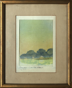
Painting - Watercolour, David Alexander, 'Morning: Lake Wendouree' 1973, by David Alexander, 07/1973
This item is part of the Federation University Art Collection. The Art Collection features over 1000 works and was listed as a 'Ballarat Treasure' in 2007.Small framed landscape, 1973Lower left "Morning, Lake Wendouree July 1973art, artwork, david alexander, lake wendouree, available -
Vision Australia
Work on paper - Text, Anna Fairclough, Presidents interpretation
Background information on portraits of past presidents of Vision Australia Foundation.1 Word document providing a background to various Presidents whose portraits hung at Vision Australia Foundation head officenon-fictionBackground information on portraits of past presidents of Vision Australia Foundation.vision australia foundation, william paterson, tilly aston, david robertson, thomas marks, malcolm daubney, john wicking, john moule, diana jones, h.m. lightfoot, george maxwell, bruce small -
Federation University Art Collection
Artwork - Painting, [Mountains] by David Alexander
Small framed watercolour depicting mountains.nonedavid alexander, landscape, mountains -
Federation University Art Collection
Artwork - Painting, David Alexander, [Landscape] by David Alexander
David ALEXANDER Small framed watercolour depicting an Australian landscape.nonedavid alexander, landscape, available -
 Mrs Aeneas Gunn Memorial Library
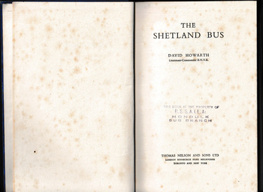
Book, Thomas Nelson, The Shetland bus, 1952
The story of small boat operations in Norway in World War TwoIndex, ill, maps, p.215.non-fictionThe story of small boat operations in Norway in World War Twoworld war 1939-1945 - naval operations - britain, underground movements - norway -
Tarnagulla History Archive
Photographs: Laanecoorie Weir In Flood, 1956, 1956
David Gordon Collection. Series of five small monochrome photographs of Laanecoorie Weir In Flood, on June 3rd 1956. Taken at Laanecoorie, Victoria.water, flood -
Tarnagulla History Archive
Newsletter: Tarnagulla Talk (Issue July 1997), 1997
David Gordon Collection. Issue of newsletter Tarnagulla Talk (Issue July 1997). Includes a small article on the Hancock family ancestors.news -
 Tarnagulla History Archive
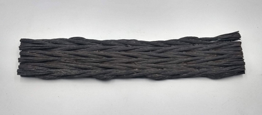
Two sections of Flat Wire Rope used in Tarnagulla mines c.1886
David Gordon Collection. These are an interested relic from the 1880s when the Prince of Wales and Old Poverty Company converted their winding machinery from flat wire rope to round wire rope. The old rope of some hundreds of metres in length was simply dragged clear of the mine and discarded in the surrounding bushland. This style of rope succeeded the old Indian hemp flat rope, and was in turn superseded by the round wire rope. These segments are most instructive and quite rare relics. The smaller segment measures approximately 40 x 10cm. The longer segment measures approximately 96 by 10cm -
 Mont De Lancey
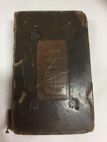
Book, Oxford University Press, The Book of Common Prayer and the Administration of the Sacraments, c. 1819 The Psalms of David section is dated 1824
A small, The Book of Common Prayer and Administration of The Sacraments and other Rites and Ceremonies of the Church, according to the use of the United Church of England and Ireland: together with The Psalters or Psalms of David pointed as they are to be sung or said in churches.A badly damaged brown leather bound Common Prayer book with faded red edges to the pages. On the front and back covers stamped inside a tan rectangular shape - is: Society for Promoting Christian Knowledge and the spine has five raised bands across it. There is a Contents page at the front. At the back there is a New Version of the Psalms of David fitted to the tunes used in churches, 1824. Pp. 320, plus the ad0iitional non paginated Psalms section at the back. non-fictionA small, The Book of Common Prayer and Administration of The Sacraments and other Rites and Ceremonies of the Church, according to the use of the United Church of England and Ireland: together with The Psalters or Psalms of David pointed as they are to be sung or said in churches.religious books, hymns, prayers, psalms -
 Wodonga & District Historical Society Inc
Photograph - Mac's Hotel, Wodonga, c1870s
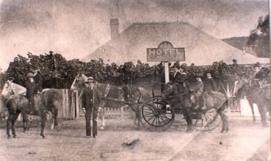
“Mac's Hotel" in Wodonga West, one of Wodonga's earliest hotels, was owned by William Christie McFarlane who arrived in Melbourne in December 1854 from Stirling, Scotland. He spent his first three years mining for gold at Beechworth. For the next three years he was the manager of the King’s Hotel at Wooragee, which was owned by his father-in-law, Charles David King. In 1860 he bought 180 acres of land at Wodonga, eventually extending his holdings to 1,000 acres on which he farmed. He called his property “Abbey Craig” after his home in Scotland. In time he owned several properties in Wodonga, a small vineyard and 'Mac's Hotel'. Mac’s Hotel was a popular meeting place for teamsters and other travellers on the Sydney Road. It opened in the early 1860s and the license was at times in the name of W. C. McFarlane and at other times held by his wife, Mary McFarlane. William had several positions during his life in Wodonga including serving as Postmaster and conducting a Commission and Insurance Agency business. He was appointed Secretary to the first Wodonga Building Society. W. C. McFarlane also filled the position of Sheriff’s Officer, Registrar of Births and Deaths and Marriages, and Justice of the Peace. W. C. McFarlane served as a member of the Wodonga Shire Council for several years including three terms as Shire President: 1889-90, 1890-1891 and 1894-95. He passed away in Wodonga in December 1906. After his death, the license of Mac’s Hotel continued to be held by Mary McFarlane until her death in November 1910. The license was not renewed and the hotel was taken over as a residence by their son, Walter McFarlane. Unfortunately, on 25 January 1913, Walter was assisting neighbours fighting grass fires about 3 miles away when his own home was completely destroyed by fire, bringing to an end the long history of the popular hostelry, Mac’s Hotel.This image is significant because it documents an early business in Wodonga conducted by a prominent Wodonga resident.Black and white image of people standing, on horseback and in coach outside Mac' Hotel, West Wodongamac's hotel, hotels wodonga -
 Wodonga & District Historical Society Inc
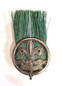
Uniform - Scout Master's Hat Badge, Whistle and Gilwell Woggle
These items were regular elements of a Scout Master's equipment. The hat badge and the woggle were specifically part of the Leader's uniform and differed from similar uniform items of younger or more junior scouts. The first proposal to form a Scouts Corps in Wodonga was raised at a public meeting in Wodonga in November 1909. One of their earliest activities in January 1910 was a march from Wodonga to Bright and return with Scouts from Albury. This first Troop was probably called the 1st Belvoir Scouts. Several other attempts were made to form Scout Troops in Wodonga over the ensuing years. In 1929 the Boy Scout Movement was taken up seriously at Wodonga by approximately 40 boys, together with 30 Cubs (juniors). However this was short-lived. Over the following decade several Scout Troops were formed but lapsed and several Wodonga boys joined the Albury Scout Troop. In 1939 Mr Ray Foster, with eight members put the Scouts on a more enduring basis. Their meeting place was a room below the Water Tower. During the early 1940s the 1st Wodonga Scouts struggled for Leaders to run the activities because so many people were caught up in the Second World War (either overseas or domestically). Mr David Mann gathered together all the small scouting groups in the Wodonga area and turned them from disorganised and disconnected groups into one scouting unit. He led the Scouts in their formative years and went on to become the 1st Wodonga Scouts first King's Scout. He had a long association with the 1st Wodonga Scouts and all the district scouting troops over the following decades. David Mann was also instrumental in the late 1940s in working for a Scout Hall to be built in Reid Street, Wodonga to secure a permanent home. These items were donated by a former member of the 1st Wodonga Scout Group who shared positive memories of the leadership of David Mann and the lessons learned in the Scouting Movement.These items are significant because they are representative of an important local, national and international organisation.A set of Scout uniform equipment including a Scout Master's Hat Badge, a whistle and a knotted leather woggle.On badge" Scout Symbol above "BE PREPARED" Engraved on Whistle - Fleur de Lis symbolwodonga scouts, 1st wodonga scouts, scouting equipment, david mann -
 Melbourne Legacy
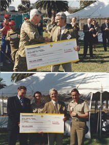
Photograph - Legacy Appeal 1995, Albert Park Relay, 1995
Photos of an Army Logistic Command Lake Relay with Legacy being the beneficiary of the proceeds raised totally $21,000. The accompanying label explains it is an annual sporting event on the defence calendar. It was held at Albert Park Lake on 27 September 1995. Legatee President David Millie, attended the event and collected the 'small' cheque on Legacy's behalf. The label also says "Our warm thanks to the Army Logistics Command Lake Relay Committee members and all the sponsors." Ron Barassi also attended the event. Ron was a great ambassador for Legacy for many years. Legacy had helped his mother and himself after his father, Corporal Ronald James Barassi, was killed in action at Tobruk in 1941, aged 27.A record of a promotional event involving the army and Ron Barassi in 1995.Colour photo x 15 of a Albert Park Lake Relay event with Ron Barassi attending, paper label. Article in The Answer.legacy promotion, answer, ron barassi, army, relay, donations, david millie -
 Monbulk RSL Sub Branch
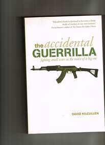
Book, David Kilcullen, The accidental guerrillan : Fighting small wars in the midst of a big one, 2009
n The Accidental Guerrilla, Kilcullen takes us on the ground to uncover the face of modern warfare, illuminating both the global challenge (the "War on Terrorism") and small wars across the world: Afghanistan, Iraq, Indonesia, Thailand, East Timor, and Pakistan. He explains that today's conflicts are a complex hybrid of contrasting trends: local social networks and worldwide movements; traditional and postmodern culture; local insurgencies seeking autonomy and a broader terrorist campaign. He warns that the United States has tended to conflate these trends, blurring the distinction between local and global struggles and thereby enormously complicating our challenges. The West has continually misidentified insurgents with limited aims and legitimate grievances - "accidental guerrillas" - as members of a unified worldwide terror network. We must learn how to disentangle these strands, develop strategies that deal with global threats, avoid local conflicts where possible, and win them where necessary.Index, ill, p.346.non-fictionn The Accidental Guerrilla, Kilcullen takes us on the ground to uncover the face of modern warfare, illuminating both the global challenge (the "War on Terrorism") and small wars across the world: Afghanistan, Iraq, Indonesia, Thailand, East Timor, and Pakistan. He explains that today's conflicts are a complex hybrid of contrasting trends: local social networks and worldwide movements; traditional and postmodern culture; local insurgencies seeking autonomy and a broader terrorist campaign. He warns that the United States has tended to conflate these trends, blurring the distinction between local and global struggles and thereby enormously complicating our challenges. The West has continually misidentified insurgents with limited aims and legitimate grievances - "accidental guerrillas" - as members of a unified worldwide terror network. We must learn how to disentangle these strands, develop strategies that deal with global threats, avoid local conflicts where possible, and win them where necessary.guerrilla warfare, insurgencies -
 Ballarat Tramway Museum
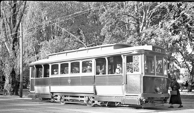
Photograph - Digital Image - tram 26 Gardens, c1937
Ballarat tram 26 at one of the Gardens Loops, c1937 with the destination of City. Possibly, the photo was taken prior to the introduction of through routing of trams introduced in August 1937 when trams no longer terminated in the City at Grenville St but ran through the city to another terminus. See item 5578. A lady in a fur collar coat carries a small case is boarding the tram. There are motor vehicles parked on the grounds behind the tram. Scan of negative collected by David Critchley of Sydney.Yield information about Ballarat 26 and the Gardens c1937.Digital image of a scan of an original negative.tramways, trams, tram 26, gardens, wendouree parade -
 Lakes Entrance Historical Society
Photograph - Johnsonville State School, 1984
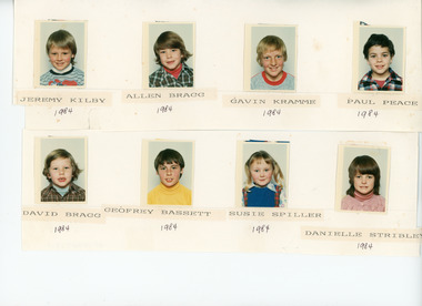
Children names - Jeremy Kilby, Allen Bragg, Gavin Kramme, Paul Peace, David Bragg, Geoffrey Bassett, Susie Spiller, Danielle Stribley.Small size photographers proofs originally stuck to large poster which has been cut for storage purposes, of eight named children from primary school Johnsonville Victoriaschools, students -
 Lakes Entrance Historical Society
Photograph - Johnsonville State School, 1985
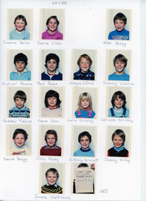
Children names - Suzanne Spiller, Denise Clues, Allen Bragg, Michael Peace, Paul Peace, Wayne Collins, Rodney Walton, Andrew Flahive, Alana Hann, Katie Stribley, Danielle Stribley, David Bragg, Colin Purdy, Jeffrey winnett, Jeremy Kilby, James Matthews.Small size photographers proofs of seventeen named children from primary school Johnsonville Victoriaschools, students -
 Ringwood and District Historical Society
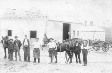
Photograph, Maroondah Highway Central, Ringwood. Workers outside D.R. Kennedy's blacksmith shop, corner of Adelaide Street and Maroondah Highway
2 photographs (1 large black and white, 1 small sepia)Typed under large photograph: "Originally Mr Tommy Grants smithy in Maroondah Hwy. Built 1880." David Robert Kennedy took over the business from Ringwood's original blacksmith mr Tommy Grant in 1894. -
 Brighton Historical Society
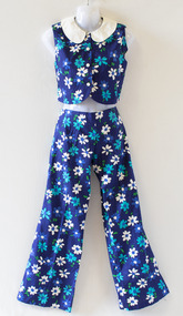
Top and pants ensemble, Watersun, Crop top and pants ensemble
Polish-born designer David Waters first began producing swimwear in 1952. His mother Halina had recently opened a stall at Melbourne Queen Victoria Markets and was looking for swimsuits to sell; unable to find any she liked, she asked David to design something. He began making swimming costumes using his mother's sewing machine, in between his shifts working at a knitting factory. He had soon set up a small business in his parents' home, cutting patterns in one room while a machinist sewed them together in the next. His company, which he named Watersun, would become an iconic Australian swimwear label. During the early 1960s, Watersun developed its "Unquestionable Bra", an inbuilt moulded bra which was marketed as giving wearers a more natural bustline than other labels. The company was also known for its matching swimwear and beachwear, producing dresses, kaftans, tops and skirts in identical colours and prints to those used for many of its swimsuits. By 1967, the company was reportedly one of Australia's two biggest swimwear manufacturers, with over one hundred employees. Watersun was sold to Ada Productions in 1984 and was later acquired by Trackerjack Australasia. This piece is believed to be one of a large quantity of samples, seconds and unsold Ada Productions stock donated to Brighton Historical Society in late 1990 by Brian Samuel, who worked at the company between 1979 and 1990.Ensemble consisting of sleeveless crop top (.1) and full length pants (.2). Bold floral print features blue and white flowers on a navy blue background. Top has a white Peter Pan collar. Swing tag attached.Swing tag: "SIZE 34 / STYLE 186/11 / PRICE $13.00".swimwear, watersun, david waters, ada productions, melbourne designers -
 Brighton Historical Society
Swimsuit ensemble, Watersun
Polish-born designer David Waters first began producing swimwear in 1952. His mother Halina had recently opened a stall at Melbourne Queen Victoria Markets and was looking for swimsuits to sell; unable to find any she liked, she asked David to design something. He began making swimming costumes using his mother's sewing machine, in between his shifts working at a knitting factory. He had soon set up a small business in his parents' home, cutting patterns in one room while a machinist sewed them together in the next. His company, which he named Watersun, would become an iconic Australian swimwear label. During the early 1960s, Watersun developed its "Unquestionable Bra", an inbuilt moulded bra which was marketed as giving wearers a more natural bustline than other labels. The company was also known for its matching swimwear and beachwear, producing dresses, kaftans, tops and skirts in identical colours and prints to those used for many of its swimsuits. By 1967, the company was reportedly one of Australia's two biggest swimwear manufacturers, with over one hundred employees. Watersun was sold to Ada Productions in 1984 and was later acquired by Trackerjack Australasia. This swimsuit is believed to be one of a large quantity of samples, seconds and unsold Ada Productions stock donated to Brighton Historical Society in late 1990 by Brian Samuel, who worked at the company between 1979 and 1990.Backless lamé one-piece swimsuit (.1) with pattern of silver, blue and bronze circles in various sizes. Waist ties knotted at front for cinched-in waist. Built-in underwire bra. Sleeveless A-line jacket (.2) in same fabric, falling past hips. Front zip and close-fitting hood.Label in bra, blue with yellow sunburst logo containing the word “Watersun” in red, above the text: “32 / Unquestionable Bra”.swimwear, watersun, david waters, ada productions, melbourne designers -
 Brighton Historical Society
Swimsuit, Miss Watersun
Polish-born designer David Waters first began producing swimwear in 1952. His mother Halina had recently opened a stall at Melbourne Queen Victoria Markets and was looking for swimsuits to sell; unable to find any she liked, she asked David to design something. He began making swimming costumes using his mother's sewing machine, in between his shifts working at a knitting factory. He had soon set up a small business in his parents' home, cutting patterns in one room while a machinist sewed them together in the next. His company, which he named Watersun, would become an iconic Australian swimwear label. During the early 1960s, Watersun developed its "Unquestionable Bra", an inbuilt moulded bra which was marketed as giving wearers a more natural bustline than other labels. The company was also known for its matching swimwear and beachwear, producing dresses, kaftans, tops and skirts in identical colours and prints to those used for many of its swimsuits. By 1967, the company was reportedly one of Australia's two biggest swimwear manufacturers, with over one hundred employees. Watersun was sold to Ada Productions in 1984 and was later acquired by Trackerjack Australasia. This swimsuit is believed to be one of a large quantity of samples, seconds and unsold Ada Productions stock donated to Brighton Historical Society in late 1990 by Brian Samuel, who worked at the company between 1979 and 1990.Blue and white gingham one-piece swimsuit. Short overskirt. Two rows of white cutwork lace form a frill along neckline and down either side of back straps, which fasten with buttons. Inbuilt bra with label: "Miss Watersun", size T14.Label in bra, blue with yellow sunburst logo containing the words “Miss Watersun” in red, above the text: “T14”swimwear, watersun, david waters, ada productions, miss watersun, melbourne designers