Showing 3431 items
matching distance
-
 Stawell Historical Society Inc
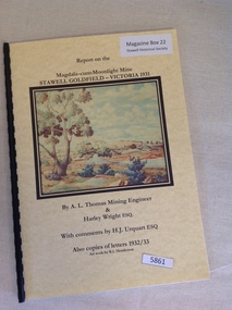
Book, A.L. Thomas & Harley Wright, Report on the Magdala-Cum-Moonlight Mine Stawell Goldfield Victoria 1931
Report on the Magdala cum Moonlight Mine 1931 By A.L. Thomas & Harley WrightYellow card cover with colour picture of bushland with a mine in the mid distance. Picture by R.L. Henderson.Report on the Magdala-cum-Moonlight Mine Stawell Goldfield - Victoria 1931 By A.L. Thomas Mining Engineer & Harley Wright Esq. With Comments by H.J Urquart Esq Also copies of letters 1932/33 Artwork by R.L. Hendersonstawell gold mining -
 Linton and District Historical Society Inc
Photograph, Gold Mine at Devil's Kitchen, Piggoreet
Looking south into Devil's Kitchen, Piggoreet with the Woady Yallock River dry bed. This photograph was originally thought to be of the Try Again Mine, however information from Joan Hunt in 2015 suggests this is the Port Arthur No. 1 Mine, located between the Devil's Kitchen and the Grand Trunk MineSmall black and white original photograph of dry creek bed with mine poppet head in distance."1920s-1930s/Devils Kitchen/Piggoreet".try again mine, port arthur no. 1 mine, devil's kitchen, piggoreet, mining, mines -
 Lakes Entrance Historical Society
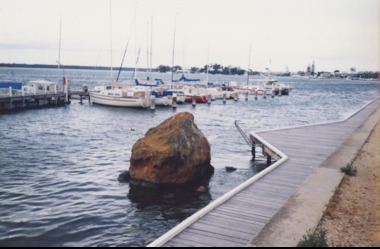
Photograph, M Holding, Boardwalk Metung Victoria, 1/11/1999 12:00:00 AM
Colour photograph of Metung Rock in the lake between the boardwalk and Marina, in distance the village of Metung Victoriapublic works, waterfront -
 Hume City Civic Collection
Photograph, early 1980s
Gellibrand Hill along with the surrounding 3 properties: Attwood, Cumberland and Woodlands were incorporated into Gellibrand Park during the 1980s. Tullamarine became Melbourne's main air terminal in 1970 and replaced Essendon Airport.A coloured landscape photograph with rounded corners of the Tullamarine Airport taken from Gellibrand Hill. A man with his back to the camera is on the RHS and another person is running down the hill on the LHS. The area in the middle distance is lightly treed and the airport is in the distance to the right of the photograph.gellibrand hill, tullamarine airport, george evans collection -
 Lakes Entrance Historical Society
Postcard - Bullock Island Lakes Entrance, H D Bulmer, 1950 c
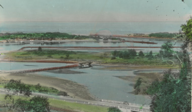
Bullock Island and first traffic bridge. Bullock Island has no development. North Arm bridge and Princes Highway in foreground, New Works area across Cunninghame Arm in distance Lakes Entrance Victoria. Also a cut down colour photograph of second humpy bridge to Bullock Island donated by M Fish number 04208.1 size 3 x 13 cm|Also two black and white photographs numbers 04208.2 and 04208.3 in SparesColour tinted postcard of Bullock Island and first traffic bridge. Bullock Island has no development. North Arm bridge and Princes Highway in foreground, New Works area across Cunninghame Arm in distance Lakes Entrance Victoria. Also a cut down colour photograph of second humpy bridge to Bullock Island donated by M Fish number 04208.1 size 3 x 13 cm|Also two black and white photographs numbers 04208.2 and 04208.3 in Spares Bullock Island and Bridge Lakes Entrance waterways, gippsland lakes, islands, vegetation -
 Bendigo Historical Society Inc.
Photograph - AERIAL VIEW BENDIGO, 1995
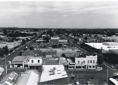
Black and white photograph: city skyline taken from St. Pauls's, Mitchell St. in foreground ( left to right ) Wills St. on RHS ( to distance ) and Garsed St. on LHS ( to distance ) Edwards St. ( next street parallel to Mitchell St. ( Noelene Wild 7.2000 )Peter Hyettplace, aerial view of bendigo -
 Kiewa Valley Historical Society
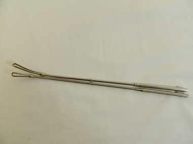
Tonsil Snare x 2
This medical instrument was used in the Tawonga District General Hospital which was built in the 1950s specifically for the increase in population due to the Kiewa Hydro Scheme.Historical: Shows the development of scientific hospital equipment. Provenance: Used in the Tawonga District General Hospital which was remote and therefore required good equipment.Stainless steel rods split at one end into a loop. Along rod is a slight shield as if to mark a distance.medical instrument. hospital equipment. tonsil. tawonga. mt beauty. -
 Phillip Island and District Historical Society Inc.
Photograph, Rose Series
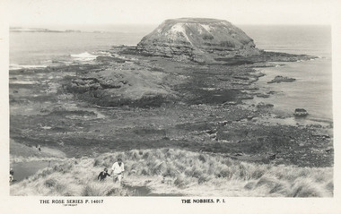
Postcard found by Lynne Allen at her late Aunt's house in 2013. Lynne Allen President of the Shoalhaven Historical Society NSWBlack & White postcard of The Nobbies. Man and boy walking along a dirt pathway. Seal Rocks in the distance.The Rose Series P. 14017. The Nobbies, P. I. the nobbies phillip island, shoalhaven historical society, lynne allen -
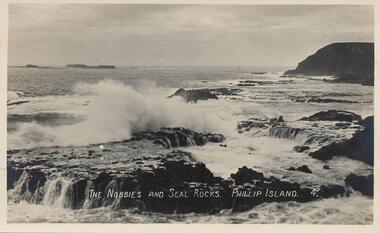 Phillip Island and District Historical Society Inc.
Photograph - Post Card, 1900
Donated by Edith ElmsBlack & White Postcard of sea crashing onto Seal Rocks with The Nobbies in background and Western Port in the distance."The Nobbies and Seal Rocks. Phillip Island. 4."the nobbies phillip island, seal rocks phillip island, phillip island, edith elms -
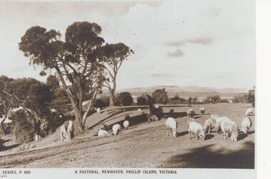 Phillip Island and District Historical Society Inc.
Photograph, Unknown
One of 20 photographs/postcards donated by Mary KarneyBlack & White copy of a postcard showing sheep grazing on pasture in Newhaven Phillip Island, with gentleman in the distance."The Rose Series P. 685" "A Pastoral, Newhaven, Phillip Island, Victoria"pastoral scene, newhaven pasture, sheep, phillip island, mary karney -
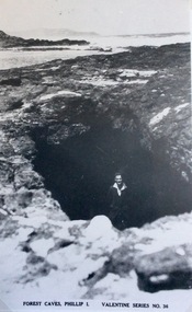 Phillip Island and District Historical Society Inc.
Photograph, Forrest Caves, Phillip island
Part of a collection of 'Rose & Valentine' series of Post Cards. Copied by John Jansson 1984View of Forrest Caves on Phillip Island, with man standing inside a cave. Cape Woolamai seen in the distance.Forest Caves, Phillip Island. Valentine Series No.36local history, photography, photographs, postcards, black & white postcard copy, forest caves, cape woolamai, phillip island -
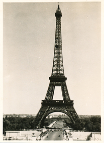 Mission to Seafarers Victoria
Photograph - Gelatin silver photograph, Allan Charles Quinn, The Eiffel Tower - Paris 6-6-49, 06 June 1949
This photograph is one of a series taken by Allan while travelling through France in mid-1946. There are several letters relating to this journey.This is a photograph from the Allan Charles Quinn collection which is a collection of letters and photograph depicting aspects of life at sea for a young man in the era immediately following World War II.A black and white photograph of the Eiffel Tower, from some distance. There is a narrow white boarder around the image.On reverse: PARIS 6-6-49 handwritten in blue ink. below this is a pencil mark, similar to "ItI"written sideways.allan-quinn, photograph, paris, france, eiffel-tower -
 Flagstaff Hill Maritime Museum and Village
Photograph
Photographs (2) on cardboard 1. Turin with view of Alps in distance 2. Venice The Campanile "Palace of the Doges"flagstaff hill, warrnambool, shipwrecked-coast, flagstaff-hill, flagstaff-hill-maritime-museum, maritime-museum, photographs, turin, venice the campanile, shipwreck-coast, flagstaff-hill-maritime-village, palace of the doges -
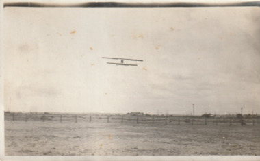 Port Melbourne Historical & Preservation Society
Photograph - Aircraft over the Bend, 1920s
Snapshot of aircraft (probably Graham Carey's) over the Bend. Scattering of buildings can be seen in the distance. 1920s.'Port Melbourne Airport'fishermans bend, transport - aviation and aerodrome, r graham carey -
 Bendigo Historical Society Inc.
Slide - PETER ELLIS COLLECTION: SLIDE, May 1970 - Jan 1972
Coloured slide transparency. Image is of a dirt road, with a building to the right in the background. Trees are in the background and a town is in the distance.Kodachrome Transparencyslide, bendigo, bendigo institute of technology -
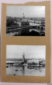
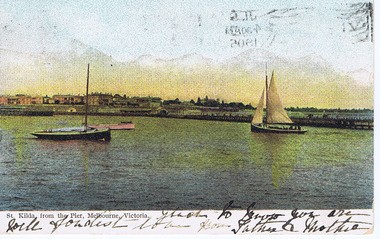 St Kilda Historical Society
Photograph, St Kilda from the Pier, 1905
postcard stamped Postcard, coloured original foreground 2 boats and pier, background in distance Marli Terrace, Esplanade hotelhand inscripton on front and back sent to London England -
 Tatura Irrigation & Wartime Camps Museum
Photograph, Children's Sand Pit Camp 3
Shows the remains of the children's sand pit which was built at Camp 3. Colour photograph on foam backing, of cement remains of a structure foundation with tree right behind and one in distance.camp 3, children's sand pit -
 Hume City Civic Collection
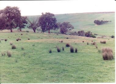
Photograph, early 1990's
The 20 photographs were taken of a number of archaeological sites in Sunbury of sacred sites and aboriginal rings. The photographs were included in a study of these sites which was published by the Shire of Bulla in the early 1990's.A view of Aboriginal Ring Site near Rupertswood. The country is undulating with trees in the middle distance and the ring in the foreground.aboriginal ring sites, george evans collection -
 Ballarat Heritage Services
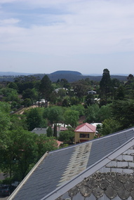
Photograph - Photograph - Colour, Mount Franklin from the Convent Gallery, Daylesford, 2015, 25/10/2015
The Convent Gallery was formerly Holy Cross Convent, and incorporates the Gold Commissioners house. An extinct volcanic mountain is seen in the distance. The slate roof of the former Holy Cross Convent in Daylesford is in the foreground. holy cross convent, presentation convent, convent gallery daylesford, slate roof, mount franklin, volcano, lalgambook -
 Kew Historical Society Inc
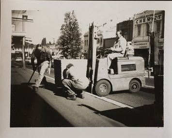
Photograph - Street Beautification: High Street
The City Engineer's Department within the former City of Kew, was responsible for public works, including in this instance, street beautification.Kew City Council workers installing planter boxes in High Street, Kew. Junction in distance at left.street beautification, city of kew -- engineers department, public works -- kew (vic.) -
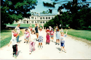 Sunbury Family History and Heritage Society Inc.
Photograph, Werribee Park Open Range Zoo, c1989
The photograph was taken when children from the Bulla primary School went on a school excursion to Werribee Park Mansion and Open Range Zoo. After doing a tour of the mansion the children stopped along the path to do some exercises together before moving on to the zoo. The excursion was part of their environmental and nature studies. The excursion to Werribee to the mansion and the zoo was included into the children's environmental and history studies. School excursions also add to their social interaction beyond the classrooms.A non-digital coloured photograph of a group of young children doing exercises in a park with a mansion in the middle distance.werribee mansion, werribee park open range zoo, bulla primary school, school excursions. -
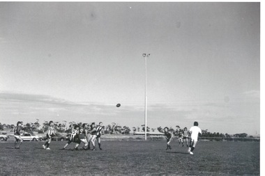 Sunbury Family History and Heritage Society Inc.
Photograph, Clarke Oval
The Sunbury Football Club, known as 'The Swifts' was formed in 1897 and the early matches were probably played on Munro's which was a stretch of land bounded by Evans, Barkly, O'Shanassy and Shields Streets. Later land adjacent to the railway line, now Sunbury Shopping Centre was where football was played until Clark Oval was opened in 1953. Since then it has been the town's main sporting venue and the site for the annual show and other events. In this photograph the football match is being played on the Clark Oval with the clubrooms visible in the background. The Sunbury Football Club is one of a number of sports clubs established vin Sunbury.A non-digital black and white photograph of a football match being played on an oval. The clubrooms are visible in the distance.sunbury football club, clark oval, "the swifts' -
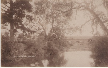 Sunbury Family History and Heritage Society Inc.
Photograph
The Jacksons Creek and the Macedon Street stone arched bridge are the features in this postcard with a view of a vineyard on the LH river bank. The wine industry was one of the early industries caroused out in Sunbury by the early European settlers in the district.A sepia photograph in post card format of a waterway with overhanging trees and an arched bridge in the middl;e distance.JACKSONS CREEK, SUNBURYjacksons creek, macedon street bridge, vineyards. -
 Vision Australia
Photograph - Image, Braille and Talking Book Library garden
Adjacent to the Braille and Talking Book Library was a small garden area. In this image, the park bench to the far left sits behind the fence facing Commercial Road.Lawn area with medium sized tree in the centre and two parks benches some distance either sidebraille & talking book library, robert de graauw -
 Lakes Entrance Historical Society
Photograph, Tambo Shire, 1994
Also second similar copyColour photograph taken at The Basin, showing hilly farmland, dense forest on ranges in distance. Buchan Victoriatopography, vegetation -
 Federation University Historical Collection
Sign, Physical Distancing in Effect, c2020
Yellow sticker for use on floor to enable physical distancing during the Covid19 pandemic (pre-vaccination development).pandemic, covid19, social distancing -
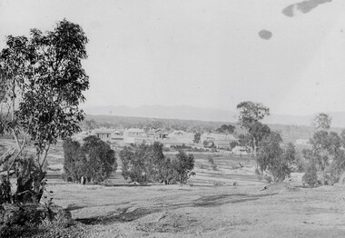 Stawell Historical Society Inc
Photograph, Pleasant Creek Stawell from Church Hill with the Shire Hall at left under construction & the Pleasant Creek Court House visible at centre 1866
Pleasant Creek Stawell from Church Hill. Shire Hall at left under construction. Pleasant Creek Court House visible at centre. Part of a collection of Photographs by Mr. O.G. Armstrong as commissioned by the Shire of Stawell for the Inter-colonial and Paris Exhibition in Melbourne in 1866 This is a photo of what was known as Pleasant Creek but was officially Stawell 1866. It is taken from Church Hill in front of the then Church of England. This would have been at what is now about 27 Seaby Street. Note: the Pleasant Creek Courthouse about centre of the picture. Buildings at centre distance with bare ground and a few trees in foreground. Pleasant Creek Courthouse at centre of image.stawell -
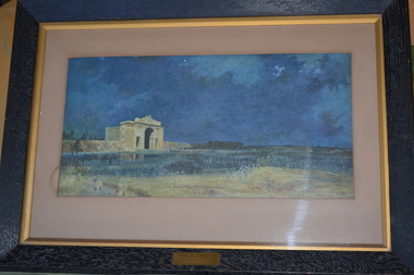 Wangaratta RSL Sub Branch
Framed print, Menin Gate at Midnight
The original art piece was painted by Australian artist Will Longstaff after he attended the unveiling ceremony of the Menin Gate memorial at the entrance of the Belgian town of Ypres in 1927. The memorial is inscribed with the names of 54,000 British and Commonwealth soldiers killed in Flanders with no known grave. More than 6000 are Australians. It was purchased in 1928 for 2000 guineas and presented to the Australia Government by British Philanthropist Lord WoolavingtonThe image commemorates those soldiers with no marked graves who died on the Western Front during the First World War.Dark wooden frame of a dark blue coloured print with large cream coloured arched monument in distance.MENIN GATE AT MIDNIGHT by Will Longstaff Presented by Lord Woolavingtonmenin gate, will longstaff, lord woolavington, ww1 -
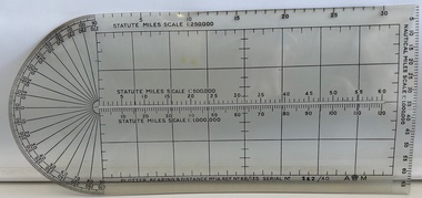 Moorabbin Air Museum
Instrument (item) - Plotter, Bearing And Distance Mark 1 A
Store Ref. No. 6B/135 No 362/40 -
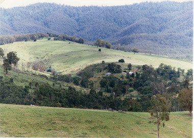
Stawell Historical Society Inc
Painting, Will Rees, "Evening Shadows" of Stawell Victoria Aug, 1929
Framed painting of field trees and Grampians Range in background. Houses in distance and what may be a smokestack. 1929To Robert Rees Morcom on his 21st Birthday May 1934. From his Grandfather Will Rees and aunt Elsie Rees.