Showing 439 items
matching early 1940s
-
 City of Moorabbin Historical Society (Operating the Box Cottage Museum)
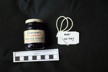
Containers, Shaving cream, blue glass jar, 20thC
Shaving cream is a cream applied to the face, or wherever else hair grows, to facilitate shaving. The use of cream achieves three effects: lubricates the cutting process; swells keratin; and de-sensitizes skin. Shaving creams commonly consist of an emulsion of oils, soaps or surfactants, and water. Until the early 20th century, bars or sticks of hard shaving soap were used. Later, tubes containing compounds of oils and soft soap were sold. Newer creams introduced in the 1940s neither produced lather nor required brushes, often referred to as brushless creams. Creams that are in tubes or tubs are commonly used with a shaving brush to produce a rich lather (most often used in wet shaving). Bristol-Myers Squibb Australia Pty Ltd is a foreign owned proprietary company that obtains its revenue through the importation and distribution of pharmaceutical products. Bristol-Myers Australia is now headquartered in Mulgrave, Victoria and with an Australian presence dating back more than 80 years, Bristol-Myers Squibb Australia is a long-standing contributor to Australia’s health and economy. A blue glass jar with a screw top lid containing 'Ingrams' men’s shaving cream. Lid : Ingrams / Shaving / Cream Bottle Label : Ingrams / Concentrated / SHAVING CREAM / A LITTLE GOES A LONGER WAY / BRISTOL MEYERS CO. PTY. LTD. SYDNEY.shaving equipment, soap, safety razor, straight razor, cutthroat razors, moorabbin, bentleigh, cheltenham, early settlers, ingram pty ltd, bristol-myer squibb australia pty ltd, shaving cream, -
 City of Moorabbin Historical Society (Operating the Box Cottage Museum)
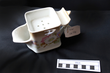
Personal Effects, china shaving mug floral, c1950
Shaving cream is a cream applied to the face, or wherever else hair grows, to facilitate shaving. The use of cream achieves three effects: lubricates the cutting process; swells keratin; and desensitizes skin. Shaving creams commonly consist of an emulsion of oils, soaps or surfactants, and water. Until the early 20th century, bars or sticks of hard shaving soap were used. Later, tubes containing compounds of oils and soft soap were sold. Newer creams introduced in the 1940s neither produced lather nor required brushes, often referred to as brushless creams. Creams that are in tubes or tubs are commonly used with a shaving brush to produce a rich lather (most often used in wet shaving). A china mug with a floral decoration. Top has a perforated base across 2/3 of the diameter to hold shaving soap/ stick and a curved ledge to hold shaving razor. Base has a wide pouring spout where a shaving brush was placed into the water stored in the mug.maynard dennis, moorabbin, cheltenham, shaving equipment, shaving mugs, razors, safety razors -
 Eltham District Historical Society Inc
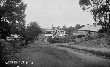
Negative - Photograph, Main Road, Eltham, c.1915
Sending postcards to family and friends including short messages was a common form of communication in the early 20th century from 1905 to the 1940s. Many were collected and kept in albums. This scene is viewed looking north along Main Road from near Bridge Street. The old Baker’s shop (Burgoyne’s store) on the corner of York is on the right. Also visible is the footpath dug by hand c.1906 between Yoirk Street and Bridge Street. On the left is ‘Derril’ or more commonly known as the Gahan House after it was purchased by Walter Ernest and Alice Miriam Gahan in 1924, on the western side of Main Road near the present-day site of Shillinglaw Cottage where they remained till about 1960 when Walter died. The house was demolished in 1968 during the widening of Main Road. In the distance on the bend is the Shillinglaw cottage with the Shillinglaw trees out front of the cottage. On the eastern side at the top of the hill (visible immediately to the left of the bakery) is the new St Mary’s Catholic Church on Henry Street near Main Road. The church site was relocated c.1912 from further south along Main Road (near Wingrove Cottage) in order to be more central to the congregation following the shifting of the township away from Little Eltham and closer to the railway station. It was subsequently destroyed by fire in 1961. On the back of the postcard is written: Printed Post Empire Care - correspondence - Address only - stamp Written in ink: 15 ? 1920 Many happy of the day I hope you and ? will have a very pleasant trip ? a great time when you reach England. ? & best wishes from your sincere friend E Harper?This photo forms part of a collection of photographs gathered by the Shire of Eltham for their centenary project book,"Pioneers and Painters: 100 years of the Shire of Eltham" by Alan Marshall (1971). The collection of over 500 images is held in partnership between Eltham District Historical Society and Yarra Plenty Regional Library (Eltham Library) and is now formally known as the 'The Shire of Eltham Pioneers Photograph Collection.' It is significant in being the first community sourced collection representing the places and people of the Shire's first one hundred years.Digital image 4 x 5 inch B&W Neg Sepia Postcard 9 x 14 cm 35mm positive transparencyshire of eltham pioneers photograph collection, eltham, main road, gahan house, bakery, footpath, postcard, shillinglaw cottage, shillinglaw trees, st marys catholic church, york street, michael aitken collection -
 Eltham District Historical Society Inc
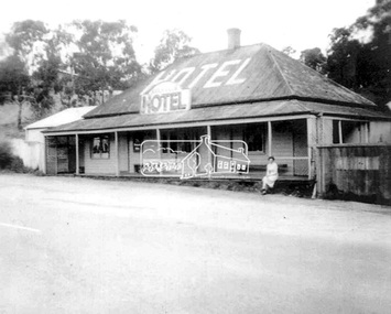
Photograph, Daughter of the owner, Miss Irene Browne, sitting on the verandah of the Lower Plenty Hotel, c.1940-c.1943
Sidney and Ivy-Jane Browne purchased the Lower Plenty ‘Golf Club’ Hotel in 1940. They owned it until 1943. Their daughter, Irene Stella, was born in Eltham in July 1923 and would have been between 17 and 20 years of age at the time this photograph was taken. Ivy-Jane (nee Williams) was born in Eltham in December 1899 and was the sister of George Alfred Williams who is commemorated on the WWI plaque at the back of St. Margaret’s church, Eltham, and whose name is also listed on the Cenotaph in front of the Eltham War Memorial in Main Road, Eltham. Irene Browne married Leslie Allan Walker in 1945 and following his death in 1958 she married Charles William Smith. She died in 2008 and is buried in Omeo Cemetery along with her husband, Charles Smith. Her granddaughter, Veronica Gunn, advises a few years earlier, Irene’s son took her to the hotel and spoke with the then owner who showed Irene the photo, which she confirmed was of herself. Digital filelower plenty, lower plenty hotel, hotels, irene stella browne, irene stella smith, golf club hotel, 1940s -
 Eltham District Historical Society Inc
Photograph, Liz Pidgeon, Heritage Excursion; East of Eltham, 6 Sep 2014, 20 May 2017
Newsletter No. 218, September 2014 September Excursion - East of Eltham Walk In Newsletter No. 197, March 2011, there was a brief history of Crown Allotment 15 Section 5 Parish of Nillumbik (CA 15) a parcel of land of a quarter of a square mile extending from Eucalyptus Road to Reynolds Road at the eastern extremity of Eltham. From the 1940s it was known as Stokes orchard. In later years it has been subdivided for residential purposes but leaving significant areas as power line and water supply reserves and bushland reserves that are habitat for the threatened For our excursion on 6th September we intend to walk through CA 15 to a bushland reserve east of Reynolds Road. The walk will traverse the boundary between suburban Eltham and the non-urban areas to the south and east. This is a pleasant walk through residential areas and bushland. Along the way we will discuss the early and more recent history of CA 15 as well as local natural history and geology. This walk is about 3.5 km in length and will take 2 to 2.5 hours. It will start at 2pm at the corner of Eucalyptus Road, Pitt Street and Nyora Road.Born Digitaleltham east, eltham district historical society, heritage excursion, activities, nyora road, reynolds road, gum tree road reserve, diosma road, stokes orchard, eucalyptus road -
 Eltham District Historical Society Inc
Photograph, Liz Pidgeon, Heritage Excursion; East of Eltham, 6 Sep 2014, 20 May 2017
Newsletter No. 218, September 2014 September Excursion - East of Eltham Walk In Newsletter No. 197, March 2011, there was a brief history of Crown Allotment 15 Section 5 Parish of Nillumbik (CA 15) a parcel of land of a quarter of a square mile extending from Eucalyptus Road to Reynolds Road at the eastern extremity of Eltham. From the 1940s it was known as Stokes orchard. In later years it has been subdivided for residential purposes but leaving significant areas as power line and water supply reserves and bushland reserves that are habitat for the threatened For our excursion on 6th September we intend to walk through CA 15 to a bushland reserve east of Reynolds Road. The walk will traverse the boundary between suburban Eltham and the non-urban areas to the south and east. This is a pleasant walk through residential areas and bushland. Along the way we will discuss the early and more recent history of CA 15 as well as local natural history and geology. This walk is about 3.5 km in length and will take 2 to 2.5 hours. It will start at 2pm at the corner of Eucalyptus Road, Pitt Street and Nyora Road.Born Digitaleltham east, eltham district historical society, heritage excursion, activities, nyora road, reynolds road, gum tree road reserve, diosma road, stokes orchard, eucalyptus road