Showing 517 items
matching east r
-
 Uniting Church Archives - Synod of Victoria
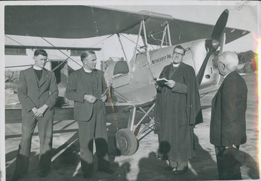
Photograph, Dedication of the Methodist Inland Mission Tiger Moth 1949, 1940
The Methodist Inland Mission Tiger Moth aircraft was dedicated at Maylands, Western Australia, before flying to the Wiluna and Meekatharra districts of Western Australia. The aircraft was named after the Rev Barclay.B & W gloss photograph of Rev A J Barcley of the Methodist Inland Mission, Rev P Clark, President of the Methodist Conference, Rev S Jenkins, Director of Home Missions, and Rev D McCaskill, pilot of the plane, at the dedication of the Tiger Moth aircraft for the Methodist Inland Mission rev d mccaskell, rev p clark, methodist inland mission, rev s jenkins, rev r j barclay -
 Uniting Church Archives - Synod of Victoria
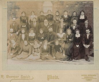
Photograph, R. Dermer Smith, California Gully, Eaglehawk Methodist Church. Sunday School Teachers and Officers c1900, c1900
Sepia photograph with a card mount of a group in front of the exterior of the Sunday School.California Gully, Eaglehawk Methodist Church. Sunday School Teachers and Officerseaglehawk methodist church sunday school -
 Uniting Church Archives - Synod of Victoria
Banner - Banners
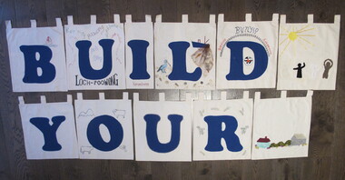
The letters of the completed banner were made by different churches within in the presbytery of Gippsland and spell a sentence, presumably, "BUILD YOUR CHURCH LORD!" Orbost was one of the churches that had the finished banner on display. 24 small banners with tabs at the top of each for hanging on a rod. 19 have large blue letters appliqued on them. Twenty two of the banners are roughly square and two are smaller and oblong. Three have no letters and are used as spacers in the four word sentence that the letters make. The banners are decorated with rural and coastal images. BN068.1 "B" with an embroidered boat with the number 1 on the sail. BN068.2 "U" fabric paint words: "LOCH POOWONG east poowong nyora strezlecki kernang athlone" BN068.3 "I" "Korumburra" BN068.4 "L" with a pelican, fishing boat with a net, shells and sand BN068.5 "D" with the UCA emblem and "BUNYIP Garfield Longwarry" BN068.6 "Y" BN068.7 "O" with fabric paint flag, ram, road and trees and a cow BN068.8 "U" BN068.9 "R" with green and yellow wattle in fabric paint BN068.10 "C" with ric-rac round the letter and three churches appliqued in the top left corner BN068.11 "H" edged with pale blue metallic fabric paint BN068.12 "U" with sunrise over the sea with gold chain sunbeams and sequins BN068.13 "R" with fine blue embroidery at each corner and only two tabs BN068.14 "C" with appliqued boat, sky and sun BN068.15 "H" with a black swan with a red beak BN068.16 "L" with appliqued and fabric painted scene of a beach, hills and city smoke on the horizon BN068.17 "O" with painted corn cobs in each corner BN068.18 "R" with cows, hills, sheep and a sack BN068.19 "D" with machine embroidered church "St Matthews Yinnar", hands "Friendship", building "UCA Yinnar", chuch "Holy Innocents YINNAR STH" "(Californian RED WOOD)", tree "BIG TREE grows at Christ Church Boolarra" BN068.20 "!" with fabric brown cow in grass BN068.21 spacer with appliqued house, bushes and barn BN068.22 spacer with appliqued sun with ribbon rays and black white and brown figures BN068.23 & BN068.24 spacer with a small UCA red dove in the centre "B U I L D Y O U R C H U R C H L O R D !"uniting church adult fellowship -
 Uniting Church Archives - Synod of Victoria
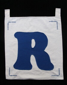
Banner
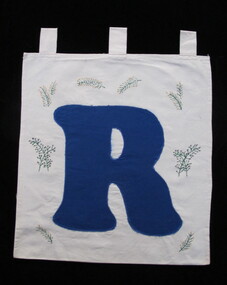
The letters of the completed banner were made by different churches within in the presbytery and spelled a sentence, presumably "BUILD YOUR CHURCH LORD!" Orbost was one of the churches that had the finished banner on display. One of 24 small banners with tabs at the top of each for hanging on a rod. 19 have large blue letters appliqued on them. Twenty two of the banners are roughly square and two are smaller and oblong. Three have no letters and are used as spacers in the four word sentence that the letters make. The banners are decorated with rural and coastal images. BN068.9 "R" with green and yellow wattle in fabric paint. This banner has wo tabs. "R"uniting church adult fellowship -
 Uniting Church Archives - Synod of Victoria
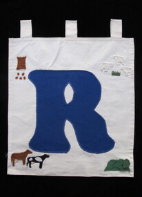
Banner
The letters of the completed banner were made by different churches within in the presbytery and spelled a sentence, presumably "BUILD YOUR CHURCH LORD!" Orbost was one of the churches that had the finished banner on display. One of 24 small banners with tabs at the top of each for hanging on a rod. 19 have large blue letters appliqued on them. Twenty two of the banners are roughly square and two are smaller and oblong. Three have no letters and are used as spacers in the four word sentence that the letters make. The banners are decorated with rural and coastal images. BN068.13 "R" with fine blue embroidery at each corner and only two tabs "R"uniting church adult fellowship -
 Uniting Church Archives - Synod of Victoria
Banner
The letters of the completed banner were made by different churches within in the presbytery and spelled a sentence, presumably "BUILD YOUR CHURCH LORD!" Orbost was one of the churches that had the finished banner on display. One of 24 small banners with tabs at the top of each for hanging on a rod. 19 have large blue letters appliqued on them. Twenty two of the banners are roughly square and two are smaller and oblong. Three have no letters and are used as spacers in the four word sentence that the letters make. The banners are decorated with rural and coastal images. BN068.18 "R" with cows, hills, sheep and a sack "R"uniting church adult fellowship -
 Uniting Church Archives - Synod of Victoria
Certificate - Methodist Girls' Comradeship Warrant, Mrs Win Mountford
Light blue card with blue print and handwriting. The warrant has both the Methodist Girls' Comradeship and Rays emblems on it."Mrs Win Mountford" "Chief Ray" "Wisteria [Hampton Sen]" "379" "Bruce R Rollins" "21st February 1964 12th March 1965 17th March 1967 Patricia Arthur I.P.SCR."methodist girls' comradeship "wisteria" no 379, win mountford, russell collins, patricia arthur, methodist girls' comradeship rays' section, bruce r rollins chief director -
 Uniting Church Archives - Synod of Victoria
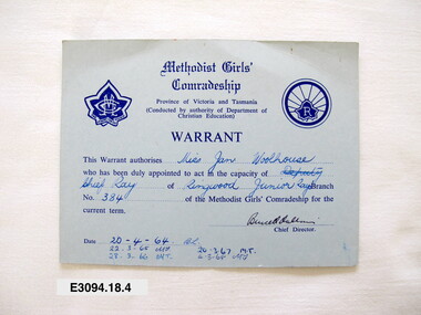
Certificate - Methodist Girls' Comradeship Warrant, Miss Jan Woolhouse
Light blue card with blue print and handwriting. The warrant has both the Methodist Girls' Comradeship and Rays emblems on it."Miss Jan Woolhouse" "Chief Ray" Ringwood Junior Rays" "384" "20-4-64 B.L. 22.3.65 MT 28.3.66 MT 20.3.67 MT 4.3.68 MT" "Bruce R Rollins"methodist girls' comradeship rays' section, jan woolhouse, methodist girls' comradeship ringwood junior rays, bruce r rollins chief director -
 Uniting Church Archives - Synod of Victoria
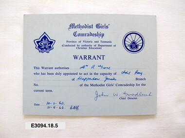
Certificate - Methodist Girls' Comradeship Warrant, Mrs R Grose
Light blue card with blue print and handwriting. The warrant has both the Methodist Girls' Comradeship and Rays emblems on it."Mrs R Grose" "Chief Ray" "Shepparton Junior" "John W Goodluck" "30-3-63 21-9-63 CMR"methodist girls' comradeship rays' section, mrs r grose, john w goodluck chief director, methodist girls' comradeship shepparton junior rays -
 Uniting Church Archives - Synod of Victoria
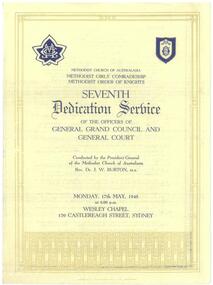
Programme - Methodist Girls' Conradeship Methodist Order of Knights, Dedication Service
This is the programme for the seventh dedication service of the officers of General Grand Council and General Court which was conducted by the President General of the Methodist Church of Australasia Rev Dr J W Burton. It was held on Monday 17 May, 1948 at 8.00pm in the Wesley Chapel, 159 Castlereagh Street Sydney. The Responsive prayer was led by Rev C Gallacher. The address was given by Rev Dr Geo A Wheen. The organist was Mr S R Stenton.Cream bi-fold paper with dark blue text and borders on three pages. The front bears an image of the MGC and MOK badges and has a gold border.methodist girls' comardeship, methodist order of knighthood, rev dr j w burton, wesley chapel castlereagh street sydney, rev c gallacher, rev w j bailey, rev dr geo a wheen, s r stenton -
 Uniting Church Archives - Synod of Victoria
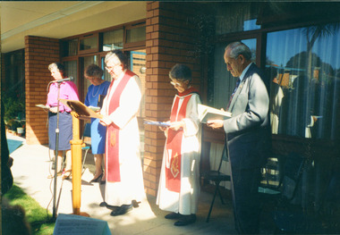
Photograph, 28 September 1993
Persons named L to R: Rev. Helen Jackson (Supervisor), Glenys Garland (Secretary), Rev. John Billington (ex Moderator), Rev. Phyllis Gorfine (Minister), Bill Adams (Chairperson)Colour photograph of a group of people gathered outside Wesley Grange Sandringhamwesley grange, sandringham, rev helen jackson, rev john billington, rev phyllis gorfine, glenys garland -
 Uniting Church Archives - Synod of Victoria
Photograph, undated
The first church building on this site faced Erica St. The "new" church was built in 1929 facing Balwyn Road. The new church was built in memory of Sir Aaron Danks. The Architect was Mr Louis R. Williams, the building contractor was Mr A. Richardson.Sepia photograph in postcard format of the Balwyn Road Methodist Church, Canterbury. The photograph shows two church buildings and part of a hall behind a picket fence.balwyn road methodst, canterbury, erica street, sir aaron danks, mr louis r. williams, mr a. richardson -
 Uniting Church Archives - Synod of Victoria
Photograph, undated c.1965
In October 1863 the Rev. James Bickford visited Sale to explore the possibilities of establishing a Methodist cause there. In March 1864 a group of 8 local men petitioned Conference to appoint a minister. The men were: Nehemiah Guthridge, G. Ross, J.H. Walters, J.E. Derrick, G.E. Hawkins, R. Gibbs, J.J. Drew, J. James. The Rev. Henry Baker arrived in the Gippsland Circuit later in 1864. The first Methodist services in Sale were held in the Mechanics Institute, but by July 1865 a Methodist church had been opened for worship. A Sunday School was constructed in 1886. The Sale Methodist Church was renovated at a cost of 2500 pounds in 1951. The new Sale Methodist Church was opened on 25 September 1965.B & W interior view of the new Sale Methodist Church. The image of the apse shows a communion table, cross, font, pulpit and flowers.methodist, sale, rev. james bickford, rev henry baker, gippsland circuit -
 Uniting Church Archives - Synod of Victoria
Photograph, 1956
In October 1863 the Rev. James Bickford visited Sale to explore the possibilities of establishing a Methodist cause there. In March 1864 a group of 8 local men petitioned Conference to appoint a minister. The men were: Nehemiah Guthridge, G. Ross, J.H. Walters, J.E. Derrick, G.E. Hawkins, R. Gibbs, J.J. Drew, J. James. The Rev. Henry Baker arrived in the Gippsland Circuit later in 1864. The first Methodist services in Sale were held in the Mechanics Institute, but by July 1865 a Methodist church had been opened for worship. A Sunday School was constructed in 1886. The Sale Methodist Church was renovated at a cost of 2500 pounds in 1951. The new Sale Methodist Church was opened on 25 September 1965.B & W exterior view of the Sale Methodist Church showing a group of women and girls, hatted and gloved, standing in front of the church.methodist, sale, rev. james bickford, rev henry baker, gippsland circuit -
 Uniting Church Archives - Synod of Victoria
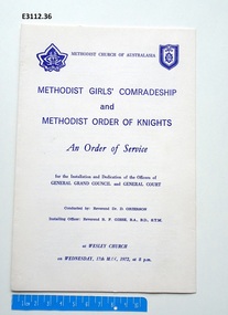
Document - Program, Methodist Girls' Comradeship and Methodist Order of Knights: An Order of Service
The service was conducted by Rev Dr D Grierson with the Installing Officer being Rev R F Giese. The Methodist Order of Knights was the official youth organisation of the Methodist Church of Australasia. It originated in Hurstville, NSW, on the 4th October 1914 by the then Mr and later Rev Alex Bray. Alex Bray was a Sunday School teacher and spoke to his class of the Knights of the Round Table. In 1917 the Order of Knights was officially recognised by the Sunday School Dept of the NSW Methodist Conference. Courts spread thoroughout Australia. In 1927 the High Court of NSW called for designs for a badge and in 1929 the General Conference of the Methodist Church of Australasia recognised the Order as an approved Organisation. In 1938 the Senior Section was organised into Degrees of Sincerity, Service and Sacrifice; the Junior Section into Pages' Degree with advancement to Esquire. In 1954 the Junior Section was reorganised into two groups: Pages 8 to 11 years and Esquires 12 to 15 years. The Knight's Motto: "Live Pure, Speak True, Right Wrong, Follow Christ the King, else wherefore born?" Courts of the Order: General Conference Department of the Christian Education - General Court - Provincial High Court - District Court - Local Court - Senior Court - Intermediate Court - Junior Court . Regalia: All members of the Intermediate and Senior Courts wore regalia consisting of a cloth shield superimposed by a cross of light and dark blue ribbons, and supported by a cloth collar. Esquire and Degree of Sincerity regalia: White collar and white shield. Degree of Service regalia: Green collar and shield. Degree of Sacrifice: Scarlet collar and shield. District Court regalia: Blue collar and gold shield. High Court regalia: Gold collar and purple sheild. General Court regalia: Purple collar and shield. Officers of the local courts wore their symbols as part of their regalia.Order of Service for a joint service of the Methodist Girls' Comradeship and Methodist Order of Knights for the Installation and Dedication of the Officers of General Grand Council and General Court at Wesley Church on Wednesday, 17th May, 1972 at 8pm. The document has both the MGC and MOK symbols on its cover. methodist order of knights, methodist girls' comradeship, rev dr d grierson, rev r f giese -
 Uniting Church Archives - Synod of Victoria
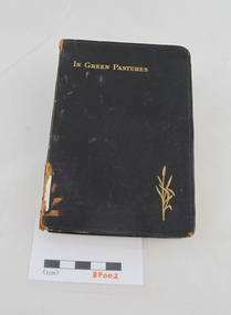
Book, Miller, J. R, In green pastures: daily readings for every day of the year, c1904
Soft covered black leather book leather book with gilt embossing on the cover and spine edges. 243 pages. Inscription on the title page. non-fictione. sprott, methodist sabbath school sydney road brunswick -
 Uniting Church Archives - Synod of Victoria
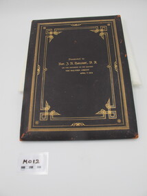
Illuminated Testimonial, Rev J R Harcourt
... and East Malvern. Rev J R Harcourt Illuminated Testimonial ...Rev. James Harcourt (1866-1938) was the son of Rev John Harcourt. He was the first student of Queen's College to graduate at the University of Melbourne. He was a chaplain of Wesley College and a tutor at Queens College for six years. In 1909 he became Minister of Glendearg Grove Church in Malvern. Brown leather and gilt the inside is lined with watered silk on the left and a richly illuminated text on the right. The top has images of two churches and the borders are decorated with blue, yellow and red flowers. It is signed on behalf of the Malvern Circuit - Glendearg Grove and East Malvern.rev james richmond harcourt 1866 - 1938, malvern circuit - glendearg grove and east malvern -
 Uniting Church Archives - Synod of Victoria
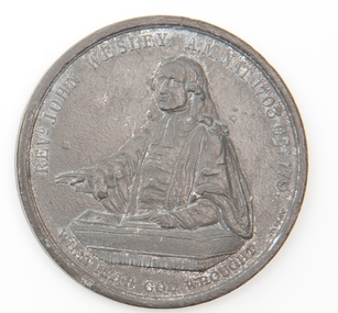
Medallion
Round medallion with an image of the John Wesley and text on the obverse and text on the reverse.Obverse "REVD JOHN WESLEY A.M. NAT 1703 OBI 1791" "WHAT GOD HATH WROUGHT" Reverse "THE NINETY-THIRD CONVERGENCE OF THE WESLEYAN METHODISTS (THE FIRST HELD IN BIRMINGHAM" "THE REV D BUNTING PRESIDENT THE REV R NEWTON SECRETARY THE REV DR FISK REPRESENTATIVE FROM AMERICA THE REV ? STEWART ? WAUGH FROM IRELAND"wesleyan church -
 Uniting Church Archives - Synod of Victoria
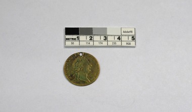
Token
These tokens, or jetons, were used in card and board games. Brass token, or jeton, with an image of George III on the obverse and a crown and shield on the reverse. Both sides have text around the edge. There is a hole in the top edge.Obverse: "GEORGIVS III DEI GRATIA" Reverse: "C.W.B.E.T. CO. DG.I.REX F.D. R 1790 B.I.R.M" -
 Uniting Church Archives - Synod of Victoria
Plaque - Wall plaque
The foundation stone for the new church was laid by the then Prime Minister, Mr R G Menzies, in 1953. The tender of 13,300 pounds submitted by Mr R S Grills was accepted in 1952. Work was completed in November 1958. The cost of the carpets was met by the Ladies' Guild and the windows in the children's chapel were given in memory of the Rev T W Leggatt by members of his family. The Rev T J Riddle was the minister at Glen Iris Presbyterian Church from 1941 - 1956.Oblong brass commemorative plaque with black text and holes at each corner."TO THE GLORY OF GOD" "THIS BUILDING WAS OPENED FOR WORSHIP ON NO.21ST 1953" "MINISTER - REV. T.J.RIDDLE B.A." "ARCHITECT - KEITH REID A.R.A.I.A." "DIP. M.U.A.A. BUILDER - R.J.GRILLS"rev t j riddle, presbyterian moderator, rev t j riddle presbyterian minister, glen iris presbyterian church, r s grills builder, keith reid architect -
 Uniting Church Archives - Synod of Victoria
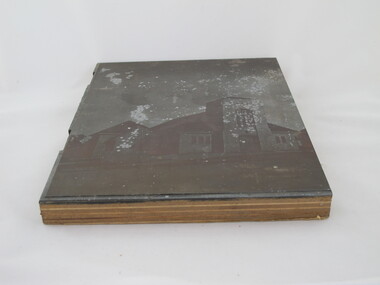
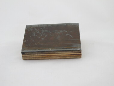
Photographic print block
Glen Iris Presbyterian Church on the corners of High Street and Allison Avenue. The foundation stone was laid by Prime Minister Mr R. G. Menzies and was opened on 21 November 1953. This photograph is on page 1 of the publication "Glen Iris Presbyterian Church Jubliee History".Outside view of Glen Iris Presbyterian Church.On back "Glen Iris Presbyterian"glen iris presbyterian church -
 Uniting Church Archives - Synod of Victoria
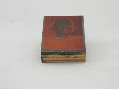
Photographic print block
Glen Iris Presbyterian Church on the corner of High Street and Allison Avenue. The foundation stone was laid by Prime Minister Mr R. G. Menzies and was opened on 21 November 1953. Head and shoulders image of Rev Marsh, Presbyterian minister.On back: "Rev [?] Marsh" "27"glen iris presbyterian church, marsh, rev -
 Uniting Church Archives - Synod of Victoria
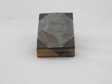
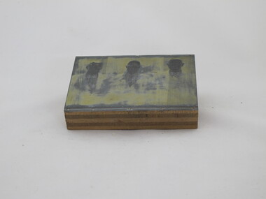
Photographic print block
Glen Iris Presbyterian Church on the corner of High Street and Allison Avenue. The foundation stone was laid by Prime Minister Mr R. G. Menzies and was opened on 21 November 1953. The Rev Leggatt was the first minister of Glen Iris Presbyterian Church and this image is on page 3 of the publication "Glen Iris Presbyterian Church Jubilee History.Head and shoulders image of Rev T. W. Leggatt, Presbyterian minister.On back: "24"glen iris presbyterian church, leggatt, t. w., rev -
 Uniting Church Archives - Synod of Victoria
Photographic print block
Glen Iris Presbyterian Church on the corner of High Street and Allison Avenue. The foundation stone was laid by Prime Minister Mr R. G. Menzies and was opened on 21 November 1953. The Rev Leggatt was the first minister of Glen Iris Presbyterian Church and this image is on page 13 of the publication "Glen Iris Presbyterian Church Jubilee History.Interior of hall showing school age boys sitting on wooden benches.On back: "10"glen iris presbyterian church -
 Uniting Church Archives - Synod of Victoria
Photographic print block
Wood block with metal photographic plate. Head and shoulders of three men wearing suits.On back: "22" "Glen Iris Presby" " Mr W S Noble" "Mr G. L. D. Don" "Mr R. F. Ingram"glen iris presbyterian church, noble, w.s., don, g. l.d., ingram, r.f. -
 Uniting Church Archives - Synod of Victoria
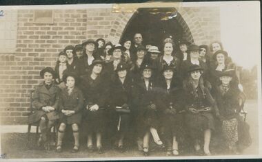
Photograph, 1939
The new Dimboola Methodist Church was opened on May 20th 1939 by the President of Conference the Rev. R. L. McDonald.Sepia group photograph of 2 children and women of the Dimboola Methodist Guild with the minister, the Rev. W.T. Lapthorne at the opening of the new Dimboola Methodist Church in 1939.Dimboola Methodist Guild. Opening of new church 1939.dimboola methodist, ladies' guild, minister, w.t. lapthorne, r.l. mcdonald, president of conference -
 Uniting Church Archives - Synod of Victoria
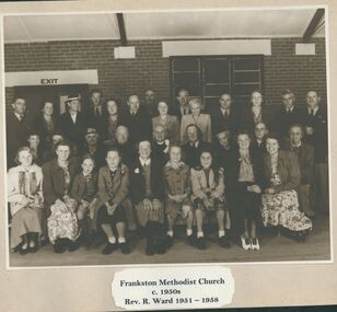
Photograph, 1947
Rev. Robert W. Ward served in Frankston 1951 - 1958. His status dates from 1928.Sepia photograph mounted on card. A group of people from Frankston Methodist Church with their minister, the Rev. R. Ward.rev. robert w. ward, frankston methodist church -
 Victorian Aboriginal Corporation for Languages
Conference proceedings, Joe Blythe, Maintaining the links : language, identity and the land : proceedings of the Seventh FEL Conference, Broome, Western Australia, 22-24 September 2003, 2003
Major headings: Languages & Land claims; Toponymy & Topography; Planning for the future; Language, identity & the environment; Language & Identity: Home & Away; Language revitalisation: Maintenance; Documenting ENdangered LanguagesMaps, graphs, word listsland claims, east kimberley, ecotourism, nsw, borroloola, gurr-goni, maningrida -
 Victorian Aboriginal Corporation for Languages
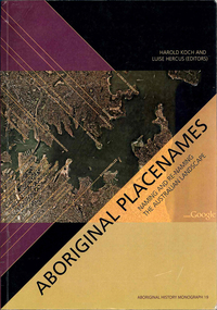
Book, Harold Koch, Aboriginal placenames : naming and re-naming the Australian landscape, 2009
"Aboriginal approaches to the naming of places across Australia differ radically from the official introduced Anglo-Australian system. However, many of these earlier names have been incorporated into contemporary nomenclature, with considerable reinterpretations of their function and form. Recently, state jurisdictions have encouraged the adoption of a greater number of Indigenous names, sometimes alongside the accepted Anglo-Australian terms, around Sydney Harbour, for example. In some cases, the use of an introduced name, such as Gove, has been contested by local Indigenous people." "The 19 studies brought together in this book present an overview of current issues involving Indigenous placenames across the whole of Australia, drawing on the disciplines of geography, linguistics, history, and anthropology. They include meticulous studies of historical records, and perspectives stemming from contemporary Indigenous communities. The book includes a wealth of documentary information on some 400 specific placenames, including those of Sydney Harbour, the Blue Mountains, Canberra, western Victoria, the Lake Eyre district, the Victoria River District, and southwestern Cape York Peninsula." -- Publisher description. Contents: Introduction: Old and new aspects of Indigenous place-naming /? Harold Koch and Luise Hercus NSW &? ACT: 1. Aboriginal placenames around Port Jackson and Botany Bay, New South Wales, Australia: sources and uncertainties /? Val Attenbrow 2. Reinstating Aboriginal placenames around Port Jackson and Botany Bay /? Jakelin Troy and Michael Walsh 3. The recognition of Aboriginal placenames in New South Wales /? Greg Windsor 4. New insights into Gundungurra place naming /? Jim Smith 5. The methodology of reconstructing Indigenous placenames: Australian Capital Territory and south-eastern New South Wales /? Harold Koch Victoria: 6. Toponymic books and the representation of Indigenous identities /? Laura Kostanski 7. Reviving old Indigenous names for new purposes /? Laura Kostanski and Ian D. Clark 8. Reconstruction of Aboriginal microtoponymy in western and central Victoria: case studies from Tower Hill, the Hopkins River, and Lake Boga /? Ian Clark South Australia &? Central Australia: 'Aboriginal names of places in southern South Australia': placenames in the Norman B.Tindale collection of papers /? Paul Monaghan 10. Why Mulligan is not just another Irish name: Lake Callabonna, South Australia /? J.C. McEntee 11. Murkarra, a landscape nearly forgotten: the Arabana country of the noxious insects, north and northwest of Lake Eyre /? Luise Hercus 12. Some area names in the far north-east of South Australia /? Luise Hercus 13. Placenames of central Australia: European records and recent experience /? Richard Kimber Northern Australia: 14. Naming Bardi places /? Claire Bowern 15. Dog-people: the meaning of a north Kimberley story /? Mark Clendon 16. 'Where the spear sticks up': the variety of locatives in placenames in the Victoria River District, Northern Territory /? Patrick McConvell 17. 'This place already has a name' /? Melanie Wilkinson, Dr R. Marika and Nancy M. Williams 18. Manankurra: what's in a name? placenames and emotional geographies /? John J. Bradley and Amanda Kearney 19. Kurtjar placenames /? Paul Black.Maps, b&w photographs, tables, word listsaustralian placenames, sociolinguistics, linguistics, anthropology, sydney harbour placenames, blue mountains placenames, canberra placenames, western victoria placenames, lake eyre placenames, victoria river district placenames, cape york peninsula placenames -
 Robin Boyd Foundation
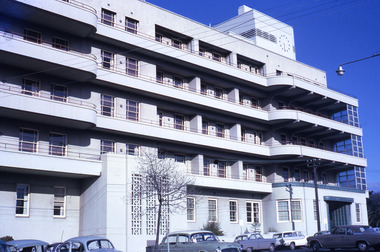
Slide, Robin Boyd
Colour slide in a mount. Mercy Hospital, East Melbourne, Victoria, Australia (1934) . (Architects: Stephenson and Meldrum (later Stephenson and Turner).)Made in Australia / 6 / Encircled 13 (Handwritten) / R (Handwritten)melbourne, slide